EP2728337A1 - Plant species identification device, method, and program - Google Patents
Plant species identification device, method, and program Download PDFInfo
- Publication number
- EP2728337A1 EP2728337A1 EP12805076.2A EP12805076A EP2728337A1 EP 2728337 A1 EP2728337 A1 EP 2728337A1 EP 12805076 A EP12805076 A EP 12805076A EP 2728337 A1 EP2728337 A1 EP 2728337A1
- Authority
- EP
- European Patent Office
- Prior art keywords
- plant species
- data
- spectral data
- feature
- reflectance
- Prior art date
- Legal status (The legal status is an assumption and is not a legal conclusion. Google has not performed a legal analysis and makes no representation as to the accuracy of the status listed.)
- Granted
Links
Images



Classifications
-
- G—PHYSICS
- G06—COMPUTING OR CALCULATING; COUNTING
- G06V—IMAGE OR VIDEO RECOGNITION OR UNDERSTANDING
- G06V20/00—Scenes; Scene-specific elements
- G06V20/10—Terrestrial scenes
- G06V20/188—Vegetation
-
- G—PHYSICS
- G01—MEASURING; TESTING
- G01N—INVESTIGATING OR ANALYSING MATERIALS BY DETERMINING THEIR CHEMICAL OR PHYSICAL PROPERTIES
- G01N21/00—Investigating or analysing materials by the use of optical means, i.e. using sub-millimetre waves, infrared, visible or ultraviolet light
- G01N21/84—Systems specially adapted for particular applications
-
- G—PHYSICS
- G01—MEASURING; TESTING
- G01N—INVESTIGATING OR ANALYSING MATERIALS BY DETERMINING THEIR CHEMICAL OR PHYSICAL PROPERTIES
- G01N21/00—Investigating or analysing materials by the use of optical means, i.e. using sub-millimetre waves, infrared, visible or ultraviolet light
- G01N21/17—Systems in which incident light is modified in accordance with the properties of the material investigated
- G01N2021/1793—Remote sensing
- G01N2021/1797—Remote sensing in landscape, e.g. crops
-
- G—PHYSICS
- G01—MEASURING; TESTING
- G01N—INVESTIGATING OR ANALYSING MATERIALS BY DETERMINING THEIR CHEMICAL OR PHYSICAL PROPERTIES
- G01N21/00—Investigating or analysing materials by the use of optical means, i.e. using sub-millimetre waves, infrared, visible or ultraviolet light
- G01N21/84—Systems specially adapted for particular applications
- G01N2021/8466—Investigation of vegetal material, e.g. leaves, plants, fruits
Definitions
- the present invention is related to an identification technology of plant species in a vegetation survey using remote sensing from a satellite or an aircraft.
- a first survey method an identification person surveys a location of plants on foot, and visually determines situations at the location.
- a second survey method is a method (remote sensing) in which the identification person discriminates the plants by using photographs and images captured by a satellite or an aircraft. These methods are used separately or by combining them.
- GIS Geographic Information System
- NDVI Normalized Difference Vegetation Index
- a satellite (satellite name: EO-1 (sensor name: Hyperion), satellite name : PROBA (sensor name: CHRIS)) mounting a hyperspectral sensor capable of measuring a band, which is ten times more than a conventional multispectral sensor, was launched as a global environmental satellite or the like, and measurement is performed by the hyperspectral sensor.
- An information amount acquired by using the hyperspectral sensor is dramatically improved.
- an airborne hyperspectral sensor has been developed, and has begun to be utilized in various fields including environmental and agricultural fields.
- a method is known in which image data indicating a forest current state are divided into small segments and the tree species are determined for each of the small segments of the image data. Also, another method is known in which multiple sets of band data are acquired based on an proper time for analysis of the tree species, a mask process is performed for NDVI for each of the tree species by generating a target extraction map for each of the tree species in which an upper and lower limit values are set for a luminance value for each set of the band data, and a tree species distribution is extracted.
- a further method is known in which luminance values of the image data of a forest taken from the sky are planarized at peaks and valleys, an area is divided depending on a space change of the luminance values of the image data being planarized, the crown shape and its texture feature amount are calculated, and the tree species is determined based on the texture feature amount of an existing crown.
- hyperspectral sensor hyperspectral camera
- Hyperspectral data acquired by the hyperspectral sensor include spectral data including wavelength information and light intensity information for each coordinate (for each pixel) in an image. It may be said that the hyper spectral data correspond to data of a three dimensional structure having an element as the spectral data in a two dimensional element as an image. Accordingly, by matching the hyperspectral data with NDVI to be a reference, it also becomes possible to classify a plant species.
- the spectral data of the plants change depending on an acquisition term and time (season) of data. It is possible to correct the conventional multispectral data by using reference data corresponding to the time (season) at which a matching target was acquired, or by standardizing data.
- the hyperpectral data are acquired with a more precise band more than the multispectral data, a spectrum is different between a sunlit portion exposed by sunlight and a shady portion being shaded by other leaves and branches.
- a spectrum is different between a sunlit portion exposed by sunlight and a shady portion being shaded by other leaves and branches.
- permeability in a visible light region is different from that in a near-infrared light, even if an intensity correction is conducted by an existing maximum value standardization, the spectrum of the sunlit portion does not correspond to that of the shaded portion.
- a plant species identification apparatus for identifying plant species, the apparatus including a processor configured to perform a process including: a reference data storage part configured to store reference spectral data which indicate a reflectance spectral feature classified by area segments including a sunlit portion and a shaded portion in addition to the plant species; a data input part configured to acquire hyperspectral data to be a target; and a determination part configured to specify the reflectance spectral feature of a pixel for each of pixels of the hyperspectral data from the reference data storage part and to determine the plant species of the pixels based on a classification of the reference spectral data.
- a disclosed plant species identification apparatus even in a case in which hyperspectral data include a sunlit portion and the shaded portion, it is possible to easily identify the plant species without being subject to experience of an accomplished identification person.
- FIG. 1 is a diagram illustrating a configuration example of the plant species identification apparatus in an embodiment.
- a plant species identification apparatus 1 inputs hyperspectral data (hyperspectral image data) of an identification target, which were taken by a hyperspectral sensor or a hyperspectral camera, and identifies a plant species of the identification target.
- the plant species identification apparatus 1 includes a reference data storage part 11, a data input part 12, a determination part 13, and a reference data generation part 14.
- the reference data storage part 11 stores reference spectral data being reflectance spectral data which are classified for each of the plant species and area segments.
- the plant species corresponds to types of plants to be identification targets.
- the area segments are regarded as segments of areas which are classified depending on a degree of exposing light from a light source (such as the sun).
- the area segments include a sunlit portion corresponding to an area in the sun and a shaded portion corresponding to an area in the shade due to other leaves and branches.
- the area segments include a mixed portion corresponding to an area where the sunlit portion and the shaded portion are mixed.
- Reference spectral data are generated by the reference data generation part 14 which will be described, and stored in the reference data storage part 11.
- the data input part 12 inputs the hyperspectral data 2 acquired by the hyperspectral sensor or the hyperspectral camera.
- a value with respect to a wavelength of the hyperspectral data is a value of such as relative reflectance, maximum normalized relative reflectance, or the like.
- the determination part 13 specifies the reference spectral data matching a feature of the reflectance spectral data of a pixel from multiple sets of the reference spectral data stored in the reference data storage part 11 for each of pixels of the hyperspectral data 2 being input.
- the determination part 13 determines the plant species of an extracted pixel or the plant species and area segments based on classification (the plant species and the area segment) of the specified reference spectral data.
- the determination part 13 outputs image data 3 where a determination result (the plant species, or the plant species and area segment) for each of pixels in an image of the hyperspectral data 2 is mapped.
- the determination part 13 is able to determine a suitable reference spectral data by performing two determination methods described below.
- the determination part 13 extracts feature points from each set of the reference spectral data stored in the reference data storage part 11, and acquires a numeric value set by calculating multiple predetermined arithmetic expressions. After that, the determination part 13 extracts the feature points from the reflectance spectral data of a pixel for each of pixels which are extracted from the hyperspectral data 2, acquires the numeric value set by calculating the same arithmetic expressions, compares the numeric values set of the pixel with the numeric value set for each set of the reference spectral data, and specifies the reference spectral data having a most similar numeric value set.
- the determination part 13 acquires a feature vector for each set of the reference spectral data stored in the reference data storage part 11. Also, the determination part 13 acquires the feature vector of the reflectance spectral data of pixels extracted from the hyperspectral data 2, and compares the feature vector of the spectral data of the pixels with the feature vector for each sets of the reference spectral data.
- the reference data generation part 14 regards, as teacher data, the reference spectral data (the reflectance spectral data) which are for the same plant species and in which the sunlit portion and the shaded portion are included in the area segment, and predicts the reflectance spectral data of the area mixing the sunlit portion and the shaded portion at a predetermine ratio.
- the reference data generation part 14 adds the predicted reflectance spectral data as the reference spectral data which are for the same plant species and in which the area segment corresponds to the mixed portion, into the reference data storage part 11.
- the reference data generation part 14 may appropriately change the ratio at which the sunlit portion is mixed with the shaded portion, and may predict the reference spectral data concerning the mixed portion at an arbitrary ratio.
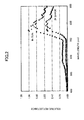
- FIG. 2 is a diagram illustrating an example of the reference spectral data stored in the reference data storage part 11.
- FIG. 2 depicts two area segments of the reference spectral data for the plant species Pinus densiflora, that is, the reflectance spectral data of the sunshine portion and the shaded portion.
- values of relative reflectance for the sunlit portion are plotted with black circles and values of relative reflectance for the shaded portion (indicated as "IN SHADE") are plotted with black triangles.
- FIG. 3 is a diagram illustrating an example of the reference spectral data in a case of including the mixed portion in the area segment.
- FIG. 3 depicts the reference spectral data of the sunlit portion ("IN SUN”) and the shaded portion (“IN SHADE”) of the same plant species and the reflectance spectral data for three types of the mixed portions predicted from these two sets of data.
- the values of the relative reflectance in the sunlit portion are plotted with black rhombuses, and the values of the relative reflectance in the shaded portion are plotted with black rectangles.
- the reference data generation part 14 generates three mixed portions: a first mixed portion (called “first mixtures”) at a ratio of “the sunlit portion 75% and the shaded portion 25%”, a second mixed portion (called “second mixtures”) at a ratio of "the sunlit portion 50% and the shaded portion 50%", and a third mixed portion (called “third mixtures”) at a ratio of "the sunlit portion 25% and the shaded portion 75%”.
- first mixtures a first mixed portion
- second mixtures at a ratio of "the sunlit portion 50% and the shaded portion 50%
- third mixtures at a ratio of "the sunlit portion 25% and the shaded portion 75%.
- the generated mixed portions are added to the reference data storage part 11.
- the first mixtures are plotted as gray triangles
- the second mixtures are plotted as cross marks
- the third mixtures are plotted as asterisks.
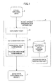
- FIG. 4 is a diagram briefly illustrating a process flow example of the plant species identification apparatus 1.
- Step S1 the data input part 12 of the plant species identification apparatus 1 acquires the hyperspectral data 2 obtained at a location which is subject to the vegetation survey.
- the relative reflectance spectral data excluding influence of a light source or the maximum normalized relative reflectance are appropriately selected.
- Step S2 the determination part 13 acquires the features of the reflectance spectral data for each of pixels in the hyperspectral data 2.
- Step S3 the determination part 13 matches the reflectance spectral data of the pixels with the reference spectral data stored in the reference data storage part 11.
- the reference spectral data are classified by the plant species and the area segment.
- the determination part 13 specifies the most likely reference spectral data.
- the determination part 13 may conduct a determination using the numeric value set calculated from the feature points of the spectral data as the above described first determination method, a determination in accordance with a Spectral Angle Mapper method, which is used by commercially available analytic software or the like in the market as the above described second determination method.
- Step S4 the determination part 13 determines the plant species and the area segment where the specified reference spectral data are classified, as the plant species and the area segment of the pixel.
- Step S5 the determination part 13 outputs as a determination result, for example, the image data 3 where a determination result (the plant species, or the plant species and area segment) with respect to each of pixels in the hyperspectral data 2 is mapped.
- the reference spectral data (the reflectance spectral data) of the sunlit portion and the shaded portion, which are to be stored in the reference storage part 11, are used in the determination, it is possible to appropriately identify the plant species even for the shaded portion where the conventional correction does not properly identify the plant species.
- the reference spectral data of the mixed portion which are to be stored in the reference storage part 11 are used in the determination, it is possible to appropriately identify the plant species for the mixed portion in sun and shade.
- FIG. 5 is a diagram illustrating an example of the features points of the reflectance spectral data.
- the spectrum of the plant is specific for each of the plant species, and may have a shape depicted in FIG. 5 , for example. Therefore, there are feature points A through E such as a minimum value, a maximum value, and the like of a spectral curve in the reflectance spectral data.
- the determination part 13 detects the feature points in the reference spectral data which are classified by the plant species and the area segment, determines multiple expressions (for example, a difference, a division, and the like) using more than two of the feature points, and acquires multiple calculated values (the numeric value set).
- the determination part 13 calculates the numeric value set for each set of the reference spectral data stored in the reference data storage part 11.
- FIG. 6 is a diagram illustrating an example of the numeric value set of the reference spectral data.
- the numeric value set derived from the detected feature points is retained for each set of the reference spectral data classified by the plant species and the area segment.
- a percentage (A/C) of the highest values a slope (CB/AB), slope percentages ((A/B)/(A/C), (CB/CD)/(CD/CE)), are used as the numeric value set.
- FIG. 7A and FIG. 7B are diagrams illustrating concrete examples of the numeric value sets of the reference spectral data for each of the plant species.
- FIG. 7A a numeric value set example of the reference spectral data, which are classified with the plant species and one area segment (the sunlit portion), is depicted.
- FIG. 7B a numeric value set example of the reference spectral data, which are classified with the plant species and multiple area segments (the sunlit portion, a portion mixing sunshine and shade at 50%, and the shaded portion), is depicted.
- the numeric value set based on the feature points of the reflectance spectral data is specific for each of the plant species.
- the determination part 13 acquires the numeric value set for each of the pixels of the hyperspectral data 2, and specifies the numeric value set of the reference spectral data, a matching process, and the most likely reference spectral data.
- Calculation for the numeric value set of the reference spectral data is executed before the determination process or during the determination process.
- a determination is performed by a Spectral Angle Mapper method, and the feature vector of the spectral data is used as the feature information of the reflectance spectral data.
- FIG. 8 is a conceptual diagram of matching similar vectors.
- the determination part 13 vectorizes the reflectance spectral data for each of the pixels of the hyperspectral data 2 and each set of the reference spectral data, and acquires similarity between the feature vector (eHS2) of the pixel and each set of the reference spectral data (eHS1) by a cosine distance (cos ⁇ ).
- the similarity (a similarity degree) among the feature vectors is calculated by the following expression.
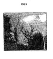
- FIG. 9 is a diagram illustrating an example of the hyperspectral data (a hyperspectral image) taken from ground level at the subject location of the vegetation survey.
- the hyperspectral data illustrated in FIG. 9 are regarded as an input of the plant species identification apparatus 1, and the identification of the plant species and the area segment is conducted.
- the determination part 13 of the plant species identification apparatus 1 was performed by image analysis software (ENVI) for the remote sensing. Also, for comparison, two processes were performed respectively, in one case (a first case) of preparing a set of the reference spectral data (the sunlit portion) alone for each of the plant species and in another case (a second case) of preparing multiple area segments (the sunlit portion and the shaded portion) for each of the plant species, as the reference spectral data.
- ENVI image analysis software
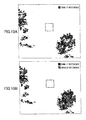
- FIG. 10A is a diagram illustrating an image data example in which plants of the same species are mapped based on a determination result in the first case.
- FIG. 10B is a diagram illustrating an image data example in which plants of the same species are mapped based on a determination result in the second case.
- mapping result in FIG. 10B represents a state much closer to the current state than the mapping result in FIG. 10A . That is, as illustrated in FIG. 10B , identification accuracy is improved by the process of the plant species identification apparatus 1.
- the plant species identification apparatus 1 is realized by a computer system including hardware including a CPU, a memory, and the like and a software program, or special hardware. That is, as illustrated in FIG. 11 , the plant species identification apparatus 1 includes a CPU (Central Processing Unit) 41, a temporary storage device 42 such as a Dynamic Random Access Memory (DRAM), a flash memory, or the like, a non-volatile storage device 43 such as Hard Disk Drive (HDD), flash memory, or the like, an input device 44, a display device 45, an output device 46, a communication I/F 47, and a drive device 48, which are connected via a bus B.
- the plant species identification apparatus 1 is operable as a computer which inputs data from outside and outputs data to outside.
- the plant species identification apparatus 1 may also be operated by a program executable for this computer.
- the program coding process contents of functions to be implemented in the plant species identification apparatus 1 are provided to the plant species identification apparatus 1.
- the provided program is executed by the computer, and the above described process functions of the plant species identification apparatus 1 are realized in the computer.
- the CPU 41 controls the plant species identification apparatus 1 in accordance with the program stored in the temporary storage device 42.
- the temporary storage device 42 stores the program executed by the CPU 41, data used for the processing of the CPU 41, data acquired in the processing of the CPU 41, and the like.
- the non-volatile storage device 43 stores data such as the program for performing various processes. A part of the program stored in the non-volatile storage device 43 is loaded in the temporary storage device 42, and is executed by the CPU 41, so that each of various processes is realized.
- the above described reference data storage part 11 corresponds to a part of the temporary storage device 42 and/or the non-volatile storage device 43.
- the input device 44 includes a mouse, a keyboard, and the like, and is used for a user to input each of various information items used in the process of the plant species identification apparatus 1.
- the display device 45 is used to display each of the various information items under control of the CPU 41.
- the output device 46 includes a printer and the like and is used to output each of the various information items in response to an instruction from the user.
- the communication I/F 47 is a device for controlling communications with an external device by connecting, for example, to the Internet, a LAN (Local Area Network), or the like.
- the computer may read the program directly from a portable recording medium, and execute the process in accordance with the program. Furthermore, the program may be recorded in a computer-readable recording medium.
- the program to realize the process conducted by the plant species identification apparatus 1 may be provided to the plant species identification apparatus 1 by a recording medium 49 such as a CD-ROM (Compact Disc Read-Only Memory). That is, when the recording medium 49 storing the program is set in the drive device 48, the drive device 48 reads out the program from the recording medium 49. The program being read out is installed into the non-volatile storage device 43 through the bus B. After that, when the program is activated, the CPU 41 begins the process in accordance with the program installed into the non-volatile storage device 43.
- a medium for storing the program is not limited to the CD-ROM, and may be the computer-readable recording medium.
- the computer-readable recording medium 49 a portable recording medium such as a DVD disk, a USB memory or the like, or a semiconductor memory such as a flash memory, as well as the CD-ROM may be used.
- the plant species identification apparatus 1 by using multiple sets of reference data corresponding to the plant species and the area segment, in particular, two sets of the reference spectral data: the sunlit portion and the shaded portion, it is possible to realize an automatic identification for the plant species with respect to a portion that was not able to be identified conventionally. Hence, according to the plant species identification apparatus 1, it is possible to easily identify the plant species without depending on the experience of an identification person.
Landscapes
- General Health & Medical Sciences (AREA)
- Health & Medical Sciences (AREA)
- Physics & Mathematics (AREA)
- General Physics & Mathematics (AREA)
- Immunology (AREA)
- Biochemistry (AREA)
- Analytical Chemistry (AREA)
- Chemical & Material Sciences (AREA)
- Life Sciences & Earth Sciences (AREA)
- Pathology (AREA)
- Engineering & Computer Science (AREA)
- Multimedia (AREA)
- Theoretical Computer Science (AREA)
- Investigating Or Analysing Materials By Optical Means (AREA)
- Image Processing (AREA)
- Image Analysis (AREA)
Abstract
Description
- The present invention is related to an identification technology of plant species in a vegetation survey using remote sensing from a satellite or an aircraft.
- In conventional vegetation survey methods, there are mainly two methods. In a first survey method, an identification person surveys a location of plants on foot, and visually determines situations at the location. A second survey method is a method (remote sensing) in which the identification person discriminates the plants by using photographs and images captured by a satellite or an aircraft. These methods are used separately or by combining them.
- A sensor using the remote sensing of the second survey method used to be panchromatic (black and white). Recently, a type of the sensor has been changing to be multispectral (colors). Hence, a specialist (identification person) investigates multispectral photographs and images, and the vegetation is identified.
- Also, recently, creation of a vegetation map using a Geographic Information System (GIS) has been mainstream. In the GIS, Normalized Difference Vegetation Index (NDVI) is used as reference information, which is prepared beforehand and indicates a crown shape of color for each of plant species, and the plant species are discriminated by conducting pattern matching for the images captured by a camera or the sensor.
- Also, in recent years, a satellite (satellite name: EO-1 (sensor name: Hyperion), satellite name : PROBA (sensor name: CHRIS)) mounting a hyperspectral sensor capable of measuring a band, which is ten times more than a conventional multispectral sensor, was launched as a global environmental satellite or the like, and measurement is performed by the hyperspectral sensor. An information amount acquired by using the hyperspectral sensor is dramatically improved. Also, an airborne hyperspectral sensor has been developed, and has begun to be utilized in various fields including environmental and agricultural fields.
- Furthermore, as a conventional method of tree species discrimination, a method is known in which image data indicating a forest current state are divided into small segments and the tree species are determined for each of the small segments of the image data. Also, another method is known in which multiple sets of band data are acquired based on an proper time for analysis of the tree species, a mask process is performed for NDVI for each of the tree species by generating a target extraction map for each of the tree species in which an upper and lower limit values are set for a luminance value for each set of the band data, and a tree species distribution is extracted.
- A further method is known in which luminance values of the image data of a forest taken from the sky are planarized at peaks and valleys, an area is divided depending on a space change of the luminance values of the image data being planarized, the crown shape and its texture feature amount are calculated, and the tree species is determined based on the texture feature amount of an existing crown.
-
- Patent Document 1: Japanese Laid-Open Patent Publication No.
2010-086276 - Patent Document 2: Japanese Laid-Open Patent Publication No.
2006-085517 - Patent Document 3: Japanese Laid-Open Patent Publication No.
2006-285310 - By acquiring information by using the hyperspectral sensor (hyperspectral camera), it is possible to acquire a larger amount of information than with the conventional multispectral sensor.
- Hyperspectral data acquired by the hyperspectral sensor include spectral data including wavelength information and light intensity information for each coordinate (for each pixel) in an image. It may be said that the hyper spectral data correspond to data of a three dimensional structure having an element as the spectral data in a two dimensional element as an image. Accordingly, by matching the hyperspectral data with NDVI to be a reference, it also becomes possible to classify a plant species.
- However, since accuracy of the hyperspectral data of plants is higher than the conventional multispectral data, the accuracy greatly changes depending on the acquisition state. Thus, it is important how to manage reference data. For example, the spectral data of the plants change depending on an acquisition term and time (season) of data. It is possible to correct the conventional multispectral data by using reference data corresponding to the time (season) at which a matching target was acquired, or by standardizing data.
- However, since the hyperpectral data are acquired with a more precise band more than the multispectral data, a spectrum is different between a sunlit portion exposed by sunlight and a shady portion being shaded by other leaves and branches. Hence, since permeability in a visible light region is different from that in a near-infrared light, even if an intensity correction is conducted by an existing maximum value standardization, the spectrum of the sunlit portion does not correspond to that of the shaded portion.
- Therefore, in a case of identifying the plant species by using the hyperspectral data for a vegetation survey, it is difficult to precisely classify the plant species in the shaded portion. Thus, the plant species have not been classified in the shaded portion or the plant species have been misclassified as another plant. Accordingly, as a result, in a semi-automatic plant species identification process, there is a problem in which precise plant classification may be degraded.
- Therefore, since a size of one pixel is smaller in the hyperspectral data acquired by measuring on ground level or from a relatively low altitude, there is no problem. In a case of the hyperspectral data taken from an artificial satellite or a relatively high altitude, there are included pixels corresponding to an area mixing the sunlit portion and the shaded portion. Accordingly, even if the spectral data of the sunlit portion and the shaded portion are used, there is a problem in which it is not possible to determine the plant species.
- It is an object of the present invention to provide an apparatus, a method, and a program in which in a case of identifying the plant species by using the hyperspectral data, the plant species are appropriately identified from data including the sunlit portion and the shaded portion.
- According to one aspect of an embodiment, there is provided a plant species identification apparatus for identifying plant species, the apparatus including a processor configured to perform a process including: a reference data storage part configured to store reference spectral data which indicate a reflectance spectral feature classified by area segments including a sunlit portion and a shaded portion in addition to the plant species; a data input part configured to acquire hyperspectral data to be a target; and a determination part configured to specify the reflectance spectral feature of a pixel for each of pixels of the hyperspectral data from the reference data storage part and to determine the plant species of the pixels based on a classification of the reference spectral data.
- According to a disclosed plant species identification apparatus, even in a case in which hyperspectral data include a sunlit portion and the shaded portion, it is possible to easily identify the plant species without being subject to experience of an accomplished identification person.
-
-
FIG. 1 is a diagram illustrating a configuration example of a plant species identification apparatus in an embodiment. -
FIG. 2 is a diagram illustrating an example of reference spectral data stored in a reference data storage part in the embodiment. -
FIG. 3 is a diagram illustrating an example of the reference spectral data in a case of including a mixed portion in an area segment in the embodiment. -
FIG. 4 is a diagram briefly illustrating a process flow example of the plant species identification apparatus in the embodiment. -
FIG. 5 is a diagram illustrating examples of feature points of the reflectance spectral data. -
FIG. 6 is a diagram illustrating an example of a numeric value set of the reference spectral data. -
FIG. 7 is a diagram illustrating concrete examples of numeric value sets of the reference spectral data for each of plant species. -
FIG. 8 is a conceptual diagram of matching similar vectors. -
FIG. 9 is a diagram illustrating an example of the hyperspectral data (a hyperspectral image) taken from ground level at a subject location of a vegetation survey in a specific process example. -
FIG. 10 is a diagram illustrating image data examples in which plants of the same species are mapped based on a determination result in the specific process example. -
FIG. 11 is a hardware configuration of the plant species identification apparatus. - In the following, a plant species identification apparatus disclosed as one aspect of the present invention will be described.
-
FIG. 1 is a diagram illustrating a configuration example of the plant species identification apparatus in an embodiment. - A plant
species identification apparatus 1 inputs hyperspectral data (hyperspectral image data) of an identification target, which were taken by a hyperspectral sensor or a hyperspectral camera, and identifies a plant species of the identification target. - The plant
species identification apparatus 1 includes a referencedata storage part 11, adata input part 12, adetermination part 13, and a referencedata generation part 14. - The reference
data storage part 11 stores reference spectral data being reflectance spectral data which are classified for each of the plant species and area segments. - The plant species corresponds to types of plants to be identification targets.
- The area segments are regarded as segments of areas which are classified depending on a degree of exposing light from a light source (such as the sun). The area segments include a sunlit portion corresponding to an area in the sun and a shaded portion corresponding to an area in the shade due to other leaves and branches. Also, the area segments include a mixed portion corresponding to an area where the sunlit portion and the shaded portion are mixed. Reference spectral data are generated by the reference
data generation part 14 which will be described, and stored in the referencedata storage part 11. - The
data input part 12 inputs thehyperspectral data 2 acquired by the hyperspectral sensor or the hyperspectral camera. - For the reflectance spectral data of the hyper
spectral data 2 being input, it is preferable that a value with respect to a wavelength of the hyperspectral data is a value of such as relative reflectance, maximum normalized relative reflectance, or the like. - The
determination part 13 specifies the reference spectral data matching a feature of the reflectance spectral data of a pixel from multiple sets of the reference spectral data stored in the referencedata storage part 11 for each of pixels of thehyperspectral data 2 being input. Thedetermination part 13 determines the plant species of an extracted pixel or the plant species and area segments based on classification (the plant species and the area segment) of the specified reference spectral data. As a result, thedetermination part 13outputs image data 3 where a determination result (the plant species, or the plant species and area segment) for each of pixels in an image of thehyperspectral data 2 is mapped. - The
determination part 13 is able to determine a suitable reference spectral data by performing two determination methods described below. - As a first determination method, the
determination part 13 extracts feature points from each set of the reference spectral data stored in the referencedata storage part 11, and acquires a numeric value set by calculating multiple predetermined arithmetic expressions. After that, thedetermination part 13 extracts the feature points from the reflectance spectral data of a pixel for each of pixels which are extracted from thehyperspectral data 2, acquires the numeric value set by calculating the same arithmetic expressions, compares the numeric values set of the pixel with the numeric value set for each set of the reference spectral data, and specifies the reference spectral data having a most similar numeric value set. - Alternatively, as a second determination method, the
determination part 13 acquires a feature vector for each set of the reference spectral data stored in the referencedata storage part 11. Also, thedetermination part 13 acquires the feature vector of the reflectance spectral data of pixels extracted from thehyperspectral data 2, and compares the feature vector of the spectral data of the pixels with the feature vector for each sets of the reference spectral data. - The reference
data generation part 14 regards, as teacher data, the reference spectral data (the reflectance spectral data) which are for the same plant species and in which the sunlit portion and the shaded portion are included in the area segment, and predicts the reflectance spectral data of the area mixing the sunlit portion and the shaded portion at a predetermine ratio. The referencedata generation part 14 adds the predicted reflectance spectral data as the reference spectral data which are for the same plant species and in which the area segment corresponds to the mixed portion, into the referencedata storage part 11. The referencedata generation part 14 may appropriately change the ratio at which the sunlit portion is mixed with the shaded portion, and may predict the reference spectral data concerning the mixed portion at an arbitrary ratio. -
FIG. 2 is a diagram illustrating an example of the reference spectral data stored in the referencedata storage part 11. - The example illustrated in
FIG. 2 depicts two area segments of the reference spectral data for the plant species Pinus densiflora, that is, the reflectance spectral data of the sunshine portion and the shaded portion. In the reflectance spectral data depicted inFIG. 2 , values of relative reflectance for the sunlit portion (indicated as "IN SUN") are plotted with black circles and values of relative reflectance for the shaded portion (indicated as "IN SHADE") are plotted with black triangles. -
FIG. 3 is a diagram illustrating an example of the reference spectral data in a case of including the mixed portion in the area segment. -
FIG. 3 depicts the reference spectral data of the sunlit portion ("IN SUN") and the shaded portion ("IN SHADE") of the same plant species and the reflectance spectral data for three types of the mixed portions predicted from these two sets of data. - In the reflectance spectral data depicted in
FIG. 3 , the values of the relative reflectance in the sunlit portion are plotted with black rhombuses, and the values of the relative reflectance in the shaded portion are plotted with black rectangles. - Also, the reference
data generation part 14 generates three mixed portions: a first mixed portion (called "first mixtures") at a ratio of "the sunlit portion 75% and the shaded portion 25%", a second mixed portion (called "second mixtures") at a ratio of "thesunlit portion 50% and the shadedportion 50%", and a third mixed portion (called "third mixtures") at a ratio of "the sunlit portion 25% and the shaded portion 75%". The generated mixed portions are added to the referencedata storage part 11. In the reflectance spectral data depicted inFIG. 3 , the first mixtures are plotted as gray triangles, the second mixtures are plotted as cross marks, and the third mixtures are plotted as asterisks. - Next, a process of the plant
species identification apparatus 1 will be briefly described. -
FIG. 4 is a diagram briefly illustrating a process flow example of the plantspecies identification apparatus 1. - Step S1: the
data input part 12 of the plantspecies identification apparatus 1 acquires thehyperspectral data 2 obtained at a location which is subject to the vegetation survey. - In the embodiment, as the
hyperspectral data 2 to be input, the relative reflectance spectral data excluding influence of a light source or the maximum normalized relative reflectance are appropriately selected. - Step S2: the
determination part 13 acquires the features of the reflectance spectral data for each of pixels in thehyperspectral data 2. - Step S3: the
determination part 13 matches the reflectance spectral data of the pixels with the reference spectral data stored in the referencedata storage part 11. The reference spectral data are classified by the plant species and the area segment. Thedetermination part 13 specifies the most likely reference spectral data. - The
determination part 13 may conduct a determination using the numeric value set calculated from the feature points of the spectral data as the above described first determination method, a determination in accordance with a Spectral Angle Mapper method, which is used by commercially available analytic software or the like in the market as the above described second determination method. - Step S4: the
determination part 13 determines the plant species and the area segment where the specified reference spectral data are classified, as the plant species and the area segment of the pixel. - Step S5: the
determination part 13 outputs as a determination result, for example, theimage data 3 where a determination result (the plant species, or the plant species and area segment) with respect to each of pixels in thehyperspectral data 2 is mapped. - By this configuration, it is possible to automatically identify to which plant species, which are recorded in the reference
data storage part 11, a pixel corresponds, for each of pixels from the hyperspectral data (image) 2 acquired at a subject location of the vegetation survey. - After that, since the reference spectral data (the reflectance spectral data) of the sunlit portion and the shaded portion, which are to be stored in the
reference storage part 11, are used in the determination, it is possible to appropriately identify the plant species even for the shaded portion where the conventional correction does not properly identify the plant species. - Furthermore, since the reference spectral data of the mixed portion which are to be stored in the
reference storage part 11, are used in the determination, it is possible to appropriately identify the plant species for the mixed portion in sun and shade. - Next, a determination process of the
determination part 13 will be described in detail. - In a first determination process example, the numeric value set specific to the plant species and the area segment which are calculated based on the feature points appearing in the spectrum, as feature information of spectrum of a plant.
-
FIG. 5 is a diagram illustrating an example of the features points of the reflectance spectral data. - The spectrum of the plant is specific for each of the plant species, and may have a shape depicted in
FIG. 5 , for example. Therefore, there are feature points A through E such as a minimum value, a maximum value, and the like of a spectral curve in the reflectance spectral data. - The
determination part 13 detects the feature points in the reference spectral data which are classified by the plant species and the area segment, determines multiple expressions (for example, a difference, a division, and the like) using more than two of the feature points, and acquires multiple calculated values (the numeric value set). - In the first determination process example, the
determination part 13 calculates the numeric value set for each set of the reference spectral data stored in the referencedata storage part 11. -
FIG. 6 is a diagram illustrating an example of the numeric value set of the reference spectral data. - As depicted in
FIG. 6 , the numeric value set derived from the detected feature points is retained for each set of the reference spectral data classified by the plant species and the area segment. - In the embodiment, four percentages, a percentage (A/C) of the highest values, a slope (CB/AB), slope percentages ((A/B)/(A/C), (CB/CD)/(CD/CE)), are used as the numeric value set.
-
FIG. 7A and FIG. 7B are diagrams illustrating concrete examples of the numeric value sets of the reference spectral data for each of the plant species. - In
FIG. 7A , a numeric value set example of the reference spectral data, which are classified with the plant species and one area segment (the sunlit portion), is depicted. InFIG. 7B , a numeric value set example of the reference spectral data, which are classified with the plant species and multiple area segments (the sunlit portion, a portion mixing sunshine and shade at 50%, and the shaded portion), is depicted. - As seen from the examples illustrated in
FIG. 7A and FIG. 7B , the numeric value set based on the feature points of the reflectance spectral data is specific for each of the plant species. - It is noted that details of a calculation process using the numeric value set of the reflectance spectral data are described in a specification of Japanese Patent Application No.
2011-074817 - Similarly, the
determination part 13 acquires the numeric value set for each of the pixels of thehyperspectral data 2, and specifies the numeric value set of the reference spectral data, a matching process, and the most likely reference spectral data. - Calculation for the numeric value set of the reference spectral data is executed before the determination process or during the determination process.
- In the second determination process, a determination is performed by a Spectral Angle Mapper method, and the feature vector of the spectral data is used as the feature information of the reflectance spectral data.
-
FIG. 8 is a conceptual diagram of matching similar vectors. - In the second determination process example, as illustrated in
FIG. 8 , thedetermination part 13 vectorizes the reflectance spectral data for each of the pixels of thehyperspectral data 2 and each set of the reference spectral data, and acquires similarity between the feature vector (eHS2) of the pixel and each set of the reference spectral data (eHS1) by a cosine distance (cosθ). - For example, the similarity (a similarity degree) among the feature vectors is calculated by the following expression. In the expression below, the closer the similarity is to 1, the more the reference spectral data are similar to reflectance spectral data.

By this configuration, the reference spectral data, which are similar to the reflectance spectral data of the pixels, are specified. - Next, a detailed process example of the plant
species identification apparatus 1 will be described. -
FIG. 9 is a diagram illustrating an example of the hyperspectral data (a hyperspectral image) taken from ground level at the subject location of the vegetation survey. - The hyperspectral data illustrated in
FIG. 9 are regarded as an input of the plantspecies identification apparatus 1, and the identification of the plant species and the area segment is conducted. - The
determination part 13 of the plantspecies identification apparatus 1 was performed by image analysis software (ENVI) for the remote sensing. Also, for comparison, two processes were performed respectively, in one case (a first case) of preparing a set of the reference spectral data (the sunlit portion) alone for each of the plant species and in another case (a second case) of preparing multiple area segments (the sunlit portion and the shaded portion) for each of the plant species, as the reference spectral data. -
FIG. 10A is a diagram illustrating an image data example in which plants of the same species are mapped based on a determination result in the first case. -
FIG. 10B is a diagram illustrating an image data example in which plants of the same species are mapped based on a determination result in the second case. - In the mapping for the image data depicted in
FIG. 10B , more pixels are mapped than the mapping illustrated inFIG. 10A . Furthermore, as seen by referring to the image data inFIG. 9 , a mapping result inFIG. 10B represents a state much closer to the current state than the mapping result inFIG. 10A . That is, as illustrated inFIG. 10B , identification accuracy is improved by the process of the plantspecies identification apparatus 1. - From the determination result illustrated in
FIG. 10B , by using data of the mixed portion as the reference spectral data of the determination result, it is possible to further improve the identification accuracy of the plant species. - Next, a hardware configuration of the plant
species identification apparatus 1 will be described. - The plant
species identification apparatus 1 is realized by a computer system including hardware including a CPU, a memory, and the like and a software program, or special hardware. That is, as illustrated inFIG. 11 , the plantspecies identification apparatus 1 includes a CPU (Central Processing Unit) 41, atemporary storage device 42 such as a Dynamic Random Access Memory (DRAM), a flash memory, or the like, anon-volatile storage device 43 such as Hard Disk Drive (HDD), flash memory, or the like, aninput device 44, adisplay device 45, anoutput device 46, a communication I/F 47, and adrive device 48, which are connected via a bus B. The plantspecies identification apparatus 1 is operable as a computer which inputs data from outside and outputs data to outside. - Also, it is possible that the plant
species identification apparatus 1 may also be operated by a program executable for this computer. In this case, the program coding process contents of functions to be implemented in the plantspecies identification apparatus 1 are provided to the plantspecies identification apparatus 1. The provided program is executed by the computer, and the above described process functions of the plantspecies identification apparatus 1 are realized in the computer. - The
CPU 41 controls the plantspecies identification apparatus 1 in accordance with the program stored in thetemporary storage device 42. Thetemporary storage device 42 stores the program executed by theCPU 41, data used for the processing of theCPU 41, data acquired in the processing of theCPU 41, and the like. - The
non-volatile storage device 43 stores data such as the program for performing various processes. A part of the program stored in thenon-volatile storage device 43 is loaded in thetemporary storage device 42, and is executed by theCPU 41, so that each of various processes is realized. - The above described reference
data storage part 11 corresponds to a part of thetemporary storage device 42 and/or thenon-volatile storage device 43. - The
input device 44 includes a mouse, a keyboard, and the like, and is used for a user to input each of various information items used in the process of the plantspecies identification apparatus 1. Thedisplay device 45 is used to display each of the various information items under control of theCPU 41. Theoutput device 46 includes a printer and the like and is used to output each of the various information items in response to an instruction from the user. The communication I/F 47 is a device for controlling communications with an external device by connecting, for example, to the Internet, a LAN (Local Area Network), or the like. - The computer may read the program directly from a portable recording medium, and execute the process in accordance with the program. Furthermore, the program may be recorded in a computer-readable recording medium.
- The program to realize the process conducted by the plant
species identification apparatus 1 may be provided to the plantspecies identification apparatus 1 by arecording medium 49 such as a CD-ROM (Compact Disc Read-Only Memory). That is, when therecording medium 49 storing the program is set in thedrive device 48, thedrive device 48 reads out the program from therecording medium 49. The program being read out is installed into thenon-volatile storage device 43 through the bus B. After that, when the program is activated, theCPU 41 begins the process in accordance with the program installed into thenon-volatile storage device 43. A medium for storing the program is not limited to the CD-ROM, and may be the computer-readable recording medium. As the computer-readable recording medium 49, a portable recording medium such as a DVD disk, a USB memory or the like, or a semiconductor memory such as a flash memory, as well as the CD-ROM may be used. - As described above, according to the plant
species identification apparatus 1, by using multiple sets of reference data corresponding to the plant species and the area segment, in particular, two sets of the reference spectral data: the sunlit portion and the shaded portion, it is possible to realize an automatic identification for the plant species with respect to a portion that was not able to be identified conventionally. Hence, according to the plantspecies identification apparatus 1, it is possible to easily identify the plant species without depending on the experience of an identification person. - The present invention is not limited to the specifically disclosed embodiments, and variations and modifications may be made without departing from the scope of the invention.
Claims (8)
- A plant species identification apparatus for identifying plant species, the apparatus comprising:a reference data storage part (11) configured to store reference spectral data which indicate a reflectance spectral feature classified by area segments including a sunlit portion and a shaded portion in addition to the plant species;a data input part (12) configured to acquire hyperspectral data to be a target; anda determination part (13) configured to specify the reflectance spectral feature of a pixel for each of pixels of the hyperspectral data from the reference data storage part (11) and to determine the plant species of the pixels based on a classification of the reference spectral data.
- The plant species identification apparatus as claimed in claim 1, further comprising a reference data generation part (14) configured to predict a reflectance spectrum of an area where the sunlit portion and the shaded portion are mixed at a predetermined ratio, to classify the reference spectral data indicating a predicted reflectance spectral feature into a same plant species and a mixed portion of the area segment, and to add the reference spectral data to the reference data storage part (11).
- The plant species identification apparatus as claimed in claim 1, wherein the determination part (13) is configured to extract feature points of the reflectance spectrum of the pixel for each of the pixels, and to acquire a numeric value set of the pixel by calculating values of the feature points being extracted using multiple expressions, and is further configured to extract the feature points from each set of the reference spectral data stored in the reference data storage part (11), to compare a specific numeric value set for the plant species and the area segment, which is acquired by calculating the values of the feature points being extracted by the multiple expressions, with the numeric value set of the pixel, and to specify the reference spectral data having a most similar numeric value set.
- The plant species identification apparatus as claimed in claim 3, wherein the numeric value set is calculated by using the values of the feature points corresponding to multiple wavelengths in the hyper spectral data.
- The plant species identification apparatus as claimed in claim 1, wherein the determination part (13) is configured to acquire a feature vector of the reflectance spectrum of the pixel, and is further configured to compare the feature vector of the reflectance spectrum of each set of the reference spectrum stored in the reference data storage part (11) with the feature vector of the pixel, and to specify the reference spectral data having a most similar feature vector.
- The plant species identification apparatus as claimed in claim 1, wherein values corresponding to the wavelengths in the hyperspectral data.
- A method performed in a computer to identify the plant species, the method comprising:acquiring hyperspectral data to be a target;referring to a reference data storage part (11) which stores reference spectral data indicating a feature of the reflectance spectral data which indicate a feature of the reflectance spectral data classified by area segments including a sunlit portion and a shaded portion in addition to the plant species, and specifying most similar reference spectral data to a feature of reflectance spectrum of a pixel from the reference data storage part (11) for each of pixels of the hyperspectral data; anddetermining the plant species of the pixels based on a classification of a specified reference spectral data.
- An plant species identification program that causes a computer to execute a process comprising:acquiring hyperspectral data to be a target;referring to a reference data storage part (11) which stores reference spectral data indicating a feature of the reflectance spectral data which indicate a feature of the reflectance spectral data classified by area segments including a sunlit portion and a shaded portion in addition to the plant species, and specifying most similar reference spectral data to a feature of reflectance spectrum of a pixel from the reference data storage part (11) for each of pixels of the hyperspectral data; anddetermining the plant species of the pixels based on a classification of a specified reference spectral data.
Applications Claiming Priority (2)
| Application Number | Priority Date | Filing Date | Title |
|---|---|---|---|
| JP2011144050 | 2011-06-29 | ||
| PCT/JP2012/066608 WO2013002349A1 (en) | 2011-06-29 | 2012-06-28 | Plant species identification device, method, and program |
Publications (3)
| Publication Number | Publication Date |
|---|---|
| EP2728337A1 true EP2728337A1 (en) | 2014-05-07 |
| EP2728337A4 EP2728337A4 (en) | 2014-12-10 |
| EP2728337B1 EP2728337B1 (en) | 2018-12-19 |
Family
ID=47424235
Family Applications (1)
| Application Number | Title | Priority Date | Filing Date |
|---|---|---|---|
| EP12805076.2A Not-in-force EP2728337B1 (en) | 2011-06-29 | 2012-06-28 | Plant species identification device, method, and computer program |
Country Status (5)
| Country | Link |
|---|---|
| US (1) | US9230170B2 (en) |
| EP (1) | EP2728337B1 (en) |
| JP (1) | JP5673823B2 (en) |
| CN (1) | CN103620381B (en) |
| WO (1) | WO2013002349A1 (en) |
Cited By (2)
| Publication number | Priority date | Publication date | Assignee | Title |
|---|---|---|---|---|
| CN109508633A (en) * | 2018-09-30 | 2019-03-22 | 广州地理研究所 | A kind of sugarcane distribution recognition methods based on optical remote sensing data |
| WO2020063461A1 (en) * | 2018-09-30 | 2020-04-02 | 广州地理研究所 | Urban extent extraction method and apparatus based on random forest classification algorithm, and electronic device |
Families Citing this family (32)
| Publication number | Priority date | Publication date | Assignee | Title |
|---|---|---|---|---|
| US9939417B2 (en) * | 2012-06-01 | 2018-04-10 | Agerpoint, Inc. | Systems and methods for monitoring agricultural products |
| CA2840436C (en) * | 2013-01-22 | 2021-02-09 | Vale S.A. | System for mapping and identification of plants using digital image processing and route generation |
| JP5950166B2 (en) * | 2013-03-25 | 2016-07-13 | ソニー株式会社 | Information processing system, information processing method of image processing system, imaging apparatus, imaging method, and program |
| JP6171732B2 (en) * | 2013-08-27 | 2017-08-02 | 富士通株式会社 | Crop discrimination device, crop discrimination program and crop discrimination method |
| CN103983584B (en) * | 2014-05-30 | 2016-06-01 | 中国科学院遥感与数字地球研究所 | The inversion method of a kind of inland case �� waters chlorophyll-a concentration and device |
| JP6413445B2 (en) * | 2014-08-01 | 2018-10-31 | 富士通株式会社 | Plant discrimination device, plant discrimination method, and plant discrimination program |
| KR101634792B1 (en) * | 2014-10-27 | 2016-06-29 | 한국지질자원연구원 | Method for detecting target material by spectral mixture analysis of hyperspectral image |
| JP6650239B2 (en) * | 2015-10-08 | 2020-02-19 | 株式会社キーエンス | Photoelectric switch |
| CN105203456B (en) * | 2015-10-28 | 2018-09-18 | 小米科技有限责任公司 | Plant variety recognition methods and device |
| JP6390054B2 (en) * | 2015-11-05 | 2018-09-19 | 株式会社Zmp | Monitoring system |
| CN106404689A (en) * | 2016-09-23 | 2017-02-15 | 广东食品药品职业学院 | Identification method of components of exocarpium |
| RU2749033C2 (en) | 2016-10-13 | 2021-06-03 | Маккейн Фудс Лимитед | Method, medium and system for detecting potato virus in agricultural crop image |
| JP6910792B2 (en) * | 2016-12-13 | 2021-07-28 | ソニーセミコンダクタソリューションズ株式会社 | Data processing equipment, data processing methods, programs, and electronics |
| EP3361235A1 (en) * | 2017-02-10 | 2018-08-15 | VoxelGrid GmbH | Device and method for analysing objects |
| CN111226261B (en) * | 2017-10-26 | 2024-12-17 | 索尼公司 | Information processing device, information processing method, program, and information processing system |
| JP7046432B2 (en) * | 2018-02-15 | 2022-04-04 | 西日本高速道路株式会社 | Tree species estimation method using satellite images and tree health determination method for tree species estimation |
| JP2019039913A (en) * | 2018-08-02 | 2019-03-14 | 株式会社Zmp | Monitoring system |
| CN110889420A (en) * | 2018-09-07 | 2020-03-17 | 华南农业大学 | Plant category identification method and system |
| CN111226747A (en) * | 2018-11-28 | 2020-06-05 | 常熟南师大发展研究院有限公司 | Device of nutrition soil for intelligent modulation plant |
| CN110657891B (en) * | 2019-09-29 | 2021-08-10 | 浙江农林大学 | Technology for identifying plants by applying multispectral investigation camera by unmanned aerial vehicle |
| CN111523587B (en) * | 2020-04-17 | 2024-02-20 | 中国科学院植物研究所 | A method for spectral identification of woody plant species based on machine learning |
| JP7715493B2 (en) * | 2020-07-06 | 2025-07-30 | ヒタチ・エナジー・リミテッド | Vegetation management system and vegetation management method |
| US20230401705A1 (en) * | 2020-11-09 | 2023-12-14 | The Regents Of The University Of California | Systems and Methods for Ground Truthing Remotely Sensed Data |
| CN112577907B (en) * | 2020-11-18 | 2023-03-31 | 上海市园林科学规划研究院 | Urban green land tree crown loss rate calculation method |
| WO2022126276A1 (en) * | 2020-12-18 | 2022-06-23 | Terramera, Inc. | Systems and methods for hyperspectral imaging of plants |
| CN112730412B (en) * | 2020-12-31 | 2021-08-10 | 河北省科学院地理科学研究所 | Hyperspectral image-based vegetation canopy shade and shade leaf distinguishing method |
| KR20220107525A (en) | 2021-01-25 | 2022-08-02 | 삼성전자주식회사 | Apparatus and method for estimating body component |
| CN113111763B (en) * | 2021-04-08 | 2023-01-24 | 洛阳师范学院 | A method and device for establishing spectral volume index and method for identifying tree species |
| CN114155450A (en) * | 2021-12-09 | 2022-03-08 | 中科计算技术西部研究院 | Method, system and storage medium for tree species identification based on hyperspectral |
| CN114295575A (en) * | 2021-12-27 | 2022-04-08 | 中国农业科学院果树研究所 | Method for identifying variety of pear by using intelligent mobile terminal |
| CN114565846A (en) * | 2022-02-24 | 2022-05-31 | 杭州睿胜软件有限公司 | Plant growing environment identification method and equipment and computer readable storage medium |
| CN117077004B (en) * | 2023-08-18 | 2024-02-23 | 中国科学院华南植物园 | Species identification method, system, device and storage medium |
Family Cites Families (18)
| Publication number | Priority date | Publication date | Assignee | Title |
|---|---|---|---|---|
| US5809164A (en) * | 1996-03-07 | 1998-09-15 | Polaroid Corporation | System and method for color gamut and tone compression using an ideal mapping function |
| JPH11283012A (en) * | 1998-03-31 | 1999-10-15 | Hitachi Software Eng Co Ltd | Method for recognizing shadow |
| AUPR457401A0 (en) * | 2001-04-26 | 2001-05-24 | Weed Control Australia Pty Ltd | Selective weed discrimination |
| JP2003006612A (en) * | 2001-06-20 | 2003-01-10 | Ntt Data Corp | Harvest prediction device and method |
| JP2006085517A (en) * | 2004-09-17 | 2006-03-30 | Hiroshima Pref Gov | Vegetation classification method of forest region by satellite data |
| JP2006285310A (en) | 2005-03-31 | 2006-10-19 | Kanazawa Univ | Forest crown evaluation method and crown evaluation program |
| AU2007217794A1 (en) * | 2006-02-16 | 2007-08-30 | Clean Earth Technologies, Llc | Method for spectral data classification and detection in diverse lighting conditions |
| JP5021293B2 (en) * | 2006-12-29 | 2012-09-05 | 株式会社パスコ | Crop growth status analysis method, crop growth status analysis device, and crop growth status analysis program |
| US8744775B2 (en) * | 2007-12-28 | 2014-06-03 | Weyerhaeuser Nr Company | Methods for classification of somatic embryos comprising hyperspectral line imaging |
| JP4900356B2 (en) * | 2008-09-30 | 2012-03-21 | 国立大学法人信州大学 | Tree species classification method and tree species classification system, forest status information creation method and forest status information creation system, thinning target area selection method and thinning target area selection system |
| JP5564812B2 (en) * | 2009-03-25 | 2014-08-06 | 独立行政法人農業環境技術研究所 | Method for continuous measurement of changes in plant growth |
| CN101692037B (en) * | 2009-09-08 | 2011-12-21 | 江苏大学 | Method for analyzing chlorophyll distribution on surface of leaves of plant by hyperspectral image and independent component |
| JP2011074817A (en) | 2009-09-30 | 2011-04-14 | Sanyo Electric Co Ltd | Axial fan |
| CN101718683B (en) * | 2009-11-10 | 2011-02-02 | 中国农业大学 | Method for fast detection of chlorophyll content in leaf blades, modeling method and detection method |
| JP4858793B2 (en) * | 2009-11-12 | 2012-01-18 | 国立大学法人信州大学 | Tree number calculation method and tree number calculation device |
| US8805083B1 (en) * | 2010-03-21 | 2014-08-12 | Jeffrey M. Sieracki | System and method for discriminating constituents of image by complex spectral signature extraction |
| JP5593255B2 (en) * | 2011-03-04 | 2014-09-17 | 株式会社日立製作所 | Vegetation control device, plant breeding system |
| JP2012196167A (en) * | 2011-03-20 | 2012-10-18 | Fujitsu Ltd | Plant species identification method |
-
2012
- 2012-06-28 JP JP2013522961A patent/JP5673823B2/en not_active Expired - Fee Related
- 2012-06-28 WO PCT/JP2012/066608 patent/WO2013002349A1/en not_active Ceased
- 2012-06-28 CN CN201280030019.XA patent/CN103620381B/en not_active Expired - Fee Related
- 2012-06-28 EP EP12805076.2A patent/EP2728337B1/en not_active Not-in-force
-
2013
- 2013-12-05 US US14/097,344 patent/US9230170B2/en active Active
Non-Patent Citations (3)
| Title |
|---|
| CLARK M L ET AL: "Hyperspectral discrimination of tropical rain forest tree species at leaf to crown scales", REMOTE SENSING OF ENVIRONMENT, ELSEVIER, XX, vol. 96, no. 3-4, 30 June 2005 (2005-06-30), pages 375-398, XP027794685, ISSN: 0034-4257 [retrieved on 2005-06-30] * |
| RUILIANG PU: "Mapping urban forest tree species using IKONOS imagery: preliminary results", ENVIRONMENTAL MONITORING AND ASSESSMENT ; AN INTERNATIONAL JOURNAL DEVOTED TO PROGRESS IN THE USE OF MONITORING DATA IN ASSESSINGENVIRONMENTAL RISKS TO MAN AND THE ENVIRONMENT, KLUWER ACADEMIC PUBLISHERS, DO, vol. 172, no. 1 - 4, 6 February 2010 (2010-02-06), pages 199-214, XP019866875, ISSN: 1573-2959, DOI: 10.1007/S10661-010-1327-5 * |
| See also references of WO2013002349A1 * |
Cited By (2)
| Publication number | Priority date | Publication date | Assignee | Title |
|---|---|---|---|---|
| CN109508633A (en) * | 2018-09-30 | 2019-03-22 | 广州地理研究所 | A kind of sugarcane distribution recognition methods based on optical remote sensing data |
| WO2020063461A1 (en) * | 2018-09-30 | 2020-04-02 | 广州地理研究所 | Urban extent extraction method and apparatus based on random forest classification algorithm, and electronic device |
Also Published As
| Publication number | Publication date |
|---|---|
| CN103620381B (en) | 2015-09-30 |
| EP2728337B1 (en) | 2018-12-19 |
| EP2728337A4 (en) | 2014-12-10 |
| US9230170B2 (en) | 2016-01-05 |
| JPWO2013002349A1 (en) | 2015-02-23 |
| JP5673823B2 (en) | 2015-02-18 |
| WO2013002349A1 (en) | 2013-01-03 |
| US20140093138A1 (en) | 2014-04-03 |
| CN103620381A (en) | 2014-03-05 |
Similar Documents
| Publication | Publication Date | Title |
|---|---|---|
| EP2728337B1 (en) | Plant species identification device, method, and computer program | |
| Su et al. | Stacked nonnegative sparse autoencoders for robust hyperspectral unmixing | |
| US10832390B2 (en) | Atmospheric compensation in satellite imagery | |
| Zhou | An object-based approach for urban land cover classification: Integrating LiDAR height and intensity data | |
| JP6064712B2 (en) | Tree species identification device and tree species identification method | |
| Petropoulos et al. | Spectral angle mapper and object-based classification combined with hyperspectral remote sensing imagery for obtaining land use/cover mapping in a Mediterranean region | |
| Zhang et al. | Extraction of tree crowns damaged by Dendrolimus tabulaeformis Tsai et Liu via spectral-spatial classification using UAV-based hyperspectral images | |
| CN110648347A (en) | Coastline extraction method and device based on remote sensing image | |
| CN114581793B (en) | Cloud recognition method, device, electronic device and readable storage medium for remote sensing images | |
| JP5910018B2 (en) | Program for identifying plant species, information processing method and apparatus | |
| Effiom et al. | Combining unmanned aerial vehicle and multispectral Pleiades data for tree species identification, a prerequisite for accurate carbon estimation | |
| Vázquez-Jiménez et al. | Thresholding algorithm optimization for change detection to satellite imagery | |
| Conti et al. | Spatial database modeling for mangrove forests mapping; example of two estuarine systems in Brazil | |
| Namikawa et al. | Water body extraction from Rapideye images: An automated methodology based on hue component of color transformation from RGB to HSV model | |
| Álvarez-Martínez et al. | Can training data counteract topographic effects in supervised image classification? A sensitivity analysis in the Cantabrian Mountains (Spain) | |
| Zhang et al. | A synergistic UAV-Landsat novel strategy for enhanced estimation of above-ground biomass and shrub dominance in Sandy land | |
| Jonckheere et al. | Image analysis of hemispherical photographs, algorithms and calculations | |
| Omruuzun et al. | Shadow removal from VNIR hyperspectral remote sensing imagery with endmember signature analysis | |
| CN120526369A (en) | Method, device, equipment and storage medium for identifying algal blooms in rivers around lakes and reservoirs | |
| Sah et al. | Semi-automated cloud/shadow removal and land cover change detection using satellite imagery | |
| Rasouli et al. | Mapping of LC/LU changes inside the Aghdam district of the Karabakh economics region applying object-based satellite image analysis | |
| JP6798337B2 (en) | Plant discrimination device, plant discrimination method and computer program for plant discrimination | |
| Rocchini et al. | From spectral to ecological information | |
| US20210285815A1 (en) | Image processing device, image processing method, and recording medium | |
| Su et al. | Identification of tree species using machine learning and phenological characteristics from a 4-year time series of remote sensing data |
Legal Events
| Date | Code | Title | Description |
|---|---|---|---|
| PUAI | Public reference made under article 153(3) epc to a published international application that has entered the european phase |
Free format text: ORIGINAL CODE: 0009012 |
|
| 17P | Request for examination filed |
Effective date: 20140122 |
|
| AK | Designated contracting states |
Kind code of ref document: A1 Designated state(s): AL AT BE BG CH CY CZ DE DK EE ES FI FR GB GR HR HU IE IS IT LI LT LU LV MC MK MT NL NO PL PT RO RS SE SI SK SM TR |
|
| DAX | Request for extension of the european patent (deleted) | ||
| A4 | Supplementary search report drawn up and despatched |
Effective date: 20141107 |
|
| RIC1 | Information provided on ipc code assigned before grant |
Ipc: G06K 9/00 20060101ALI20141103BHEP Ipc: G06T 1/00 20060101AFI20141103BHEP Ipc: G01N 21/17 20060101ALN20141103BHEP Ipc: G01N 21/84 20060101ALI20141103BHEP |
|
| REG | Reference to a national code |
Ref country code: DE Ref legal event code: R079 Ref document number: 602012054930 Country of ref document: DE Free format text: PREVIOUS MAIN CLASS: G01N0021270000 Ipc: G01N0021840000 |
|
| RIC1 | Information provided on ipc code assigned before grant |
Ipc: G01N 21/17 20060101ALN20180604BHEP Ipc: G06K 9/00 20060101ALI20180604BHEP Ipc: G01N 21/84 20060101AFI20180604BHEP |
|
| GRAP | Despatch of communication of intention to grant a patent |
Free format text: ORIGINAL CODE: EPIDOSNIGR1 |
|
| STAA | Information on the status of an ep patent application or granted ep patent |
Free format text: STATUS: GRANT OF PATENT IS INTENDED |
|
| RIC1 | Information provided on ipc code assigned before grant |
Ipc: G01N 21/17 20060101ALN20180705BHEP Ipc: G06K 9/00 20060101ALI20180705BHEP Ipc: G01N 21/84 20060101AFI20180705BHEP |
|
| INTG | Intention to grant announced |
Effective date: 20180724 |
|
| GRAS | Grant fee paid |
Free format text: ORIGINAL CODE: EPIDOSNIGR3 |
|
| GRAA | (expected) grant |
Free format text: ORIGINAL CODE: 0009210 |
|
| STAA | Information on the status of an ep patent application or granted ep patent |
Free format text: STATUS: THE PATENT HAS BEEN GRANTED |
|
| AK | Designated contracting states |
Kind code of ref document: B1 Designated state(s): AL AT BE BG CH CY CZ DE DK EE ES FI FR GB GR HR HU IE IS IT LI LT LU LV MC MK MT NL NO PL PT RO RS SE SI SK SM TR |
|
| REG | Reference to a national code |
Ref country code: GB Ref legal event code: FG4D |
|
| REG | Reference to a national code |
Ref country code: CH Ref legal event code: EP |
|
| REG | Reference to a national code |
Ref country code: IE Ref legal event code: FG4D |
|
| REG | Reference to a national code |
Ref country code: DE Ref legal event code: R096 Ref document number: 602012054930 Country of ref document: DE |
|
| REG | Reference to a national code |
Ref country code: AT Ref legal event code: REF Ref document number: 1079250 Country of ref document: AT Kind code of ref document: T Effective date: 20190115 |
|
| REG | Reference to a national code |
Ref country code: NL Ref legal event code: MP Effective date: 20181219 |
|
| PG25 | Lapsed in a contracting state [announced via postgrant information from national office to epo] |
Ref country code: HR Free format text: LAPSE BECAUSE OF FAILURE TO SUBMIT A TRANSLATION OF THE DESCRIPTION OR TO PAY THE FEE WITHIN THE PRESCRIBED TIME-LIMIT Effective date: 20181219 Ref country code: NO Free format text: LAPSE BECAUSE OF FAILURE TO SUBMIT A TRANSLATION OF THE DESCRIPTION OR TO PAY THE FEE WITHIN THE PRESCRIBED TIME-LIMIT Effective date: 20190319 Ref country code: LV Free format text: LAPSE BECAUSE OF FAILURE TO SUBMIT A TRANSLATION OF THE DESCRIPTION OR TO PAY THE FEE WITHIN THE PRESCRIBED TIME-LIMIT Effective date: 20181219 Ref country code: BG Free format text: LAPSE BECAUSE OF FAILURE TO SUBMIT A TRANSLATION OF THE DESCRIPTION OR TO PAY THE FEE WITHIN THE PRESCRIBED TIME-LIMIT Effective date: 20190319 Ref country code: LT Free format text: LAPSE BECAUSE OF FAILURE TO SUBMIT A TRANSLATION OF THE DESCRIPTION OR TO PAY THE FEE WITHIN THE PRESCRIBED TIME-LIMIT Effective date: 20181219 Ref country code: FI Free format text: LAPSE BECAUSE OF FAILURE TO SUBMIT A TRANSLATION OF THE DESCRIPTION OR TO PAY THE FEE WITHIN THE PRESCRIBED TIME-LIMIT Effective date: 20181219 |
|
| REG | Reference to a national code |
Ref country code: LT Ref legal event code: MG4D |
|
| REG | Reference to a national code |
Ref country code: AT Ref legal event code: MK05 Ref document number: 1079250 Country of ref document: AT Kind code of ref document: T Effective date: 20181219 |
|
| PG25 | Lapsed in a contracting state [announced via postgrant information from national office to epo] |
Ref country code: SE Free format text: LAPSE BECAUSE OF FAILURE TO SUBMIT A TRANSLATION OF THE DESCRIPTION OR TO PAY THE FEE WITHIN THE PRESCRIBED TIME-LIMIT Effective date: 20181219 Ref country code: RS Free format text: LAPSE BECAUSE OF FAILURE TO SUBMIT A TRANSLATION OF THE DESCRIPTION OR TO PAY THE FEE WITHIN THE PRESCRIBED TIME-LIMIT Effective date: 20181219 Ref country code: AL Free format text: LAPSE BECAUSE OF FAILURE TO SUBMIT A TRANSLATION OF THE DESCRIPTION OR TO PAY THE FEE WITHIN THE PRESCRIBED TIME-LIMIT Effective date: 20181219 Ref country code: GR Free format text: LAPSE BECAUSE OF FAILURE TO SUBMIT A TRANSLATION OF THE DESCRIPTION OR TO PAY THE FEE WITHIN THE PRESCRIBED TIME-LIMIT Effective date: 20190320 |
|
| PG25 | Lapsed in a contracting state [announced via postgrant information from national office to epo] |
Ref country code: NL Free format text: LAPSE BECAUSE OF FAILURE TO SUBMIT A TRANSLATION OF THE DESCRIPTION OR TO PAY THE FEE WITHIN THE PRESCRIBED TIME-LIMIT Effective date: 20181219 |
|
| PG25 | Lapsed in a contracting state [announced via postgrant information from national office to epo] |
Ref country code: PL Free format text: LAPSE BECAUSE OF FAILURE TO SUBMIT A TRANSLATION OF THE DESCRIPTION OR TO PAY THE FEE WITHIN THE PRESCRIBED TIME-LIMIT Effective date: 20181219 Ref country code: IT Free format text: LAPSE BECAUSE OF FAILURE TO SUBMIT A TRANSLATION OF THE DESCRIPTION OR TO PAY THE FEE WITHIN THE PRESCRIBED TIME-LIMIT Effective date: 20181219 Ref country code: CZ Free format text: LAPSE BECAUSE OF FAILURE TO SUBMIT A TRANSLATION OF THE DESCRIPTION OR TO PAY THE FEE WITHIN THE PRESCRIBED TIME-LIMIT Effective date: 20181219 Ref country code: PT Free format text: LAPSE BECAUSE OF FAILURE TO SUBMIT A TRANSLATION OF THE DESCRIPTION OR TO PAY THE FEE WITHIN THE PRESCRIBED TIME-LIMIT Effective date: 20190419 Ref country code: ES Free format text: LAPSE BECAUSE OF FAILURE TO SUBMIT A TRANSLATION OF THE DESCRIPTION OR TO PAY THE FEE WITHIN THE PRESCRIBED TIME-LIMIT Effective date: 20181219 |
|
| PG25 | Lapsed in a contracting state [announced via postgrant information from national office to epo] |
Ref country code: RO Free format text: LAPSE BECAUSE OF FAILURE TO SUBMIT A TRANSLATION OF THE DESCRIPTION OR TO PAY THE FEE WITHIN THE PRESCRIBED TIME-LIMIT Effective date: 20181219 Ref country code: SK Free format text: LAPSE BECAUSE OF FAILURE TO SUBMIT A TRANSLATION OF THE DESCRIPTION OR TO PAY THE FEE WITHIN THE PRESCRIBED TIME-LIMIT Effective date: 20181219 Ref country code: IS Free format text: LAPSE BECAUSE OF FAILURE TO SUBMIT A TRANSLATION OF THE DESCRIPTION OR TO PAY THE FEE WITHIN THE PRESCRIBED TIME-LIMIT Effective date: 20190419 Ref country code: SM Free format text: LAPSE BECAUSE OF FAILURE TO SUBMIT A TRANSLATION OF THE DESCRIPTION OR TO PAY THE FEE WITHIN THE PRESCRIBED TIME-LIMIT Effective date: 20181219 Ref country code: EE Free format text: LAPSE BECAUSE OF FAILURE TO SUBMIT A TRANSLATION OF THE DESCRIPTION OR TO PAY THE FEE WITHIN THE PRESCRIBED TIME-LIMIT Effective date: 20181219 |
|
| REG | Reference to a national code |
Ref country code: DE Ref legal event code: R097 Ref document number: 602012054930 Country of ref document: DE |
|
| PLBE | No opposition filed within time limit |
Free format text: ORIGINAL CODE: 0009261 |
|
| STAA | Information on the status of an ep patent application or granted ep patent |
Free format text: STATUS: NO OPPOSITION FILED WITHIN TIME LIMIT |
|
| PG25 | Lapsed in a contracting state [announced via postgrant information from national office to epo] |
Ref country code: AT Free format text: LAPSE BECAUSE OF FAILURE TO SUBMIT A TRANSLATION OF THE DESCRIPTION OR TO PAY THE FEE WITHIN THE PRESCRIBED TIME-LIMIT Effective date: 20181219 Ref country code: DK Free format text: LAPSE BECAUSE OF FAILURE TO SUBMIT A TRANSLATION OF THE DESCRIPTION OR TO PAY THE FEE WITHIN THE PRESCRIBED TIME-LIMIT Effective date: 20181219 |
|
| 26N | No opposition filed |
Effective date: 20190920 |
|
| PG25 | Lapsed in a contracting state [announced via postgrant information from national office to epo] |
Ref country code: MC Free format text: LAPSE BECAUSE OF FAILURE TO SUBMIT A TRANSLATION OF THE DESCRIPTION OR TO PAY THE FEE WITHIN THE PRESCRIBED TIME-LIMIT Effective date: 20181219 |
|
| REG | Reference to a national code |
Ref country code: CH Ref legal event code: PL |
|
| PG25 | Lapsed in a contracting state [announced via postgrant information from national office to epo] |
Ref country code: SI Free format text: LAPSE BECAUSE OF FAILURE TO SUBMIT A TRANSLATION OF THE DESCRIPTION OR TO PAY THE FEE WITHIN THE PRESCRIBED TIME-LIMIT Effective date: 20181219 |
|
| REG | Reference to a national code |
Ref country code: BE Ref legal event code: MM Effective date: 20190630 |
|
| PG25 | Lapsed in a contracting state [announced via postgrant information from national office to epo] |
Ref country code: TR Free format text: LAPSE BECAUSE OF FAILURE TO SUBMIT A TRANSLATION OF THE DESCRIPTION OR TO PAY THE FEE WITHIN THE PRESCRIBED TIME-LIMIT Effective date: 20181219 |
|
| PG25 | Lapsed in a contracting state [announced via postgrant information from national office to epo] |
Ref country code: IE Free format text: LAPSE BECAUSE OF NON-PAYMENT OF DUE FEES Effective date: 20190628 |
|
| PG25 | Lapsed in a contracting state [announced via postgrant information from national office to epo] |
Ref country code: LU Free format text: LAPSE BECAUSE OF NON-PAYMENT OF DUE FEES Effective date: 20190628 Ref country code: CH Free format text: LAPSE BECAUSE OF NON-PAYMENT OF DUE FEES Effective date: 20190630 Ref country code: BE Free format text: LAPSE BECAUSE OF NON-PAYMENT OF DUE FEES Effective date: 20190630 Ref country code: LI Free format text: LAPSE BECAUSE OF NON-PAYMENT OF DUE FEES Effective date: 20190630 |
|
| PG25 | Lapsed in a contracting state [announced via postgrant information from national office to epo] |
Ref country code: FR Free format text: LAPSE BECAUSE OF NON-PAYMENT OF DUE FEES Effective date: 20190630 |
|
| REG | Reference to a national code |
Ref country code: DE Ref legal event code: R082 Ref document number: 602012054930 Country of ref document: DE Representative=s name: HL KEMPNER PATENTANWAELTE, SOLICITORS (ENGLAND, DE Ref country code: DE Ref legal event code: R082 Ref document number: 602012054930 Country of ref document: DE Representative=s name: HL KEMPNER PATENTANWALT, RECHTSANWALT, SOLICIT, DE |
|
| PG25 | Lapsed in a contracting state [announced via postgrant information from national office to epo] |
Ref country code: CY Free format text: LAPSE BECAUSE OF FAILURE TO SUBMIT A TRANSLATION OF THE DESCRIPTION OR TO PAY THE FEE WITHIN THE PRESCRIBED TIME-LIMIT Effective date: 20181219 |
|
| PG25 | Lapsed in a contracting state [announced via postgrant information from national office to epo] |
Ref country code: MT Free format text: LAPSE BECAUSE OF FAILURE TO SUBMIT A TRANSLATION OF THE DESCRIPTION OR TO PAY THE FEE WITHIN THE PRESCRIBED TIME-LIMIT Effective date: 20181219 Ref country code: HU Free format text: LAPSE BECAUSE OF FAILURE TO SUBMIT A TRANSLATION OF THE DESCRIPTION OR TO PAY THE FEE WITHIN THE PRESCRIBED TIME-LIMIT; INVALID AB INITIO Effective date: 20120628 |
|
| PG25 | Lapsed in a contracting state [announced via postgrant information from national office to epo] |
Ref country code: MK Free format text: LAPSE BECAUSE OF FAILURE TO SUBMIT A TRANSLATION OF THE DESCRIPTION OR TO PAY THE FEE WITHIN THE PRESCRIBED TIME-LIMIT Effective date: 20181219 |
|
| PGFP | Annual fee paid to national office [announced via postgrant information from national office to epo] |
Ref country code: DE Payment date: 20230502 Year of fee payment: 12 |
|
| PGFP | Annual fee paid to national office [announced via postgrant information from national office to epo] |
Ref country code: GB Payment date: 20230504 Year of fee payment: 12 |
|
| REG | Reference to a national code |
Ref country code: DE Ref legal event code: R119 Ref document number: 602012054930 Country of ref document: DE |
|
| GBPC | Gb: european patent ceased through non-payment of renewal fee |
Effective date: 20240628 |
|
| PG25 | Lapsed in a contracting state [announced via postgrant information from national office to epo] |
Ref country code: DE Free format text: LAPSE BECAUSE OF NON-PAYMENT OF DUE FEES Effective date: 20250101 |
|
| PG25 | Lapsed in a contracting state [announced via postgrant information from national office to epo] |
Ref country code: GB Free format text: LAPSE BECAUSE OF NON-PAYMENT OF DUE FEES Effective date: 20240628 |