EP2726898B1 - Location estimation for a mobile device - Google Patents
Location estimation for a mobile device Download PDFInfo
- Publication number
- EP2726898B1 EP2726898B1 EP12740209.7A EP12740209A EP2726898B1 EP 2726898 B1 EP2726898 B1 EP 2726898B1 EP 12740209 A EP12740209 A EP 12740209A EP 2726898 B1 EP2726898 B1 EP 2726898B1
- Authority
- EP
- European Patent Office
- Prior art keywords
- mobile device
- location
- measurements
- landmark
- base station
- Prior art date
- Legal status (The legal status is an assumption and is not a legal conclusion. Google has not performed a legal analysis and makes no representation as to the accuracy of the status listed.)
- Active
Links
Images


Classifications
-
- H—ELECTRICITY
- H04—ELECTRIC COMMUNICATION TECHNIQUE
- H04W—WIRELESS COMMUNICATION NETWORKS
- H04W4/00—Services specially adapted for wireless communication networks; Facilities therefor
- H04W4/02—Services making use of location information
- H04W4/029—Location-based management or tracking services
-
- G—PHYSICS
- G01—MEASURING; TESTING
- G01S—RADIO DIRECTION-FINDING; RADIO NAVIGATION; DETERMINING DISTANCE OR VELOCITY BY USE OF RADIO WAVES; LOCATING OR PRESENCE-DETECTING BY USE OF THE REFLECTION OR RERADIATION OF RADIO WAVES; ANALOGOUS ARRANGEMENTS USING OTHER WAVES
- G01S19/00—Satellite radio beacon positioning systems; Determining position, velocity or attitude using signals transmitted by such systems
- G01S19/38—Determining a navigation solution using signals transmitted by a satellite radio beacon positioning system
- G01S19/39—Determining a navigation solution using signals transmitted by a satellite radio beacon positioning system the satellite radio beacon positioning system transmitting time-stamped messages, e.g. GPS [Global Positioning System], GLONASS [Global Orbiting Navigation Satellite System] or GALILEO
- G01S19/42—Determining position
- G01S19/45—Determining position by combining measurements of signals from the satellite radio beacon positioning system with a supplementary measurement
- G01S19/46—Determining position by combining measurements of signals from the satellite radio beacon positioning system with a supplementary measurement the supplementary measurement being of a radio-wave signal type
-
- G—PHYSICS
- G01—MEASURING; TESTING
- G01S—RADIO DIRECTION-FINDING; RADIO NAVIGATION; DETERMINING DISTANCE OR VELOCITY BY USE OF RADIO WAVES; LOCATING OR PRESENCE-DETECTING BY USE OF THE REFLECTION OR RERADIATION OF RADIO WAVES; ANALOGOUS ARRANGEMENTS USING OTHER WAVES
- G01S5/00—Position-fixing by co-ordinating two or more direction or position line determinations; Position-fixing by co-ordinating two or more distance determinations
- G01S5/02—Position-fixing by co-ordinating two or more direction or position line determinations; Position-fixing by co-ordinating two or more distance determinations using radio waves
- G01S5/0252—Radio frequency fingerprinting
- G01S5/02521—Radio frequency fingerprinting using a radio-map
-
- G—PHYSICS
- G01—MEASURING; TESTING
- G01S—RADIO DIRECTION-FINDING; RADIO NAVIGATION; DETERMINING DISTANCE OR VELOCITY BY USE OF RADIO WAVES; LOCATING OR PRESENCE-DETECTING BY USE OF THE REFLECTION OR RERADIATION OF RADIO WAVES; ANALOGOUS ARRANGEMENTS USING OTHER WAVES
- G01S19/00—Satellite radio beacon positioning systems; Determining position, velocity or attitude using signals transmitted by such systems
- G01S19/01—Satellite radio beacon positioning systems transmitting time-stamped messages, e.g. GPS [Global Positioning System], GLONASS [Global Orbiting Navigation Satellite System] or GALILEO
- G01S19/13—Receivers
- G01S19/14—Receivers specially adapted for specific applications
- G01S19/17—Emergency applications
-
- G—PHYSICS
- G01—MEASURING; TESTING
- G01S—RADIO DIRECTION-FINDING; RADIO NAVIGATION; DETERMINING DISTANCE OR VELOCITY BY USE OF RADIO WAVES; LOCATING OR PRESENCE-DETECTING BY USE OF THE REFLECTION OR RERADIATION OF RADIO WAVES; ANALOGOUS ARRANGEMENTS USING OTHER WAVES
- G01S5/00—Position-fixing by co-ordinating two or more direction or position line determinations; Position-fixing by co-ordinating two or more distance determinations
- G01S5/0009—Transmission of position information to remote stations
- G01S5/0018—Transmission from mobile station to base station
- G01S5/0027—Transmission from mobile station to base station of actual mobile position, i.e. position determined on mobile
Definitions
- the invention relates to a method for estimating the location of a mobile device and a mobile device implementing the same, particularly where an accurate position of the mobile device using a satellite-based positioning system is unavailable.
- Falls are one of the greatest health risk factors for elderly people. About one third of older people above the age of 65 fall at least once a year.
- PLBs personal help buttons
- PROS personal emergency response systems
- Automated fall detectors are also available that monitor the movements of the user and automatically trigger an alarm if a fall is detected.
- PHBs PHBs, PERS and fall detectors
- PHBs PHBs, PERS and fall detectors
- PHBs PHBs, PERS and fall detectors
- PHBs PHBs, PERS and fall detectors
- PHBs PHBs, PERS and fall detectors
- PHBs PHBs, PERS and fall detectors
- PHBs PHBs, PERS and fall detectors
- a base unit located nearby to the user (i.e. typically in the user's home) to a call centre when they are activated, and the personnel in the call centre can talk to the user and arrange for assistance to be sent to the user in an emergency.
- the emergency assistance can be directed to that location by the call centre personnel.
- US 2010/0194631 describes a method of determining the location of a portable device that uses GPS when it is available, and triangulation using information on cell towers when GPS is not available. This technique allows the location of a portable device to be estimated whenever a user has network coverage.
- cell tower triangulation (or similar techniques such as cell tower fingerprinting) can provide a location for the user to an accuracy of around 50 meters, although this depends on favorable network topology and having multiple cell towers in range of the user. A typical figure is much higher, e.g. 200 meters. This accuracy may not be sufficient to locate the user to the correct location or building in an emergency situation.
- WO 201/015854 A1 discloses determining the position of a mobile device by GPS at "important" locations, and obtaining and storing the cell IDs and the signal strength of the surrounding base stations in a database.
- a location corresponding to the currently visible base stations is selected from the database and used as location estimate for the mobile phone.
- Important locations are for example start and end point of a journey, and positions at which GPS reception is difficult.
- WO 2010/003898 A1 discloses periodically measuring the position of a mobile device by GPS. Geographical areas such as cells of a communciation network in which the user spends a significant amount of time are identified and their cell IDs are stored. The system also stores in a memory, for each geographical area, the average GPS location before the loss of the GPS signal. In a case of need, this estimated position can be used for locating the mobile apparatus.
- the step of analyzing the measurements to identify landmarks comprises identifying clusters in the measurements of the position of the mobile device; and identifying each identified cluster as a landmark.
- the step of analyzing the measurements to identify landmarks comprises identifying a journey undertaken by the user from consecutive measurements of the position of the user; and identifying the end point of the journey as a landmark.
- the end point of the journey corresponds to a point at which it becomes not possible to use the satellite-based positioning system to measure the position of the mobile device.
- the end point of the journey corresponds to a point at which a movement sensor in the mobile device indicates that the mobile device is no longer moving.
- the step of analyzing the measurements to identify landmarks comprises identifying a location as corresponding to a first measurement of the position of the mobile device obtained after a period of time during which the mobile device is stationary.
- the method further comprises the step of noting the time at which each measurement of the position of the mobile device is obtained; wherein the step of analyzing the measurements to identify landmarks further comprises identifying the times at which the mobile device is at each landmark; and wherein the step of estimating the location of the mobile device uses the current time and identity of the base station by which the mobile station is currently served. In this way, it is possible to determine which one of multiple locations within the coverage area of a particular base station the user is most likely to be found, based on the time of day that the user is normally found at that location.
- the method further comprises the step of obtaining measurements of the strength of signals received from the base station serving the mobile device at the time of each measurement of the position of the mobile device; wherein the step of analyzing the measurements to identify landmarks further comprises identifying the measured signal strength when the mobile device is at each landmark; and wherein the step of estimating the location of the mobile device uses the identity and current measured signal strength of the base station by which the mobile station is currently served.
- This embodiment provides another way to determine which one of multiple locations within the coverage area of a particular base station the user is most likely to be found.
- the step of estimating the location of the mobile device can comprise estimating the location of the mobile device using a recent measurement of the position of the mobile device and the one or more identified landmarks that are associated with the base station by which the mobile device is currently served. This embodiment provides yet another way to determine which one of multiple locations within the coverage area of a particular base station the user is most likely to be found.
- the step of estimating the location of the mobile device is performed after a user of the mobile device triggers an alarm or an alarm is otherwise triggered by the mobile device.
- the method preferably further comprises sending information on the one or more identified landmarks that are associated with the base station by which the mobile device is currently served from the mobile device to a remote location.
- FIG. 1 An exemplary mobile personal emergency response system (PERS) device 2 is shown in Figure 1 .
- the device 2 comprises a button 4 that can be activated by the user when they require assistance, an audible alarm unit 6 that can be used to summon the assistance of someone in the vicinity of the user when the button 4 is activated, a loudspeaker 7, transceiver circuitry 8 and associated antenna 10 for initiating a call to a call centre over a cellular telecommunication network, a microphone 11 and a GPS receiver 12 and associated antenna 14 for determining the location of the mobile PERS device 2 from received GPS signals.
- a button 4 that can be activated by the user when they require assistance
- an audible alarm unit 6 that can be used to summon the assistance of someone in the vicinity of the user when the button 4 is activated
- a loudspeaker 7, transceiver circuitry 8 and associated antenna 10 for initiating a call to a call centre over a cellular telecommunication network
- a microphone 11 and a GPS receiver 12 and associated antenna 14
- the mobile PERS device 2 also comprises a processor 16 that is connected to the button 4, alarm 6, loudspeaker 7, transceiver circuitry 8, microphone 11 and GPS receiver 12, and that controls the operation of the device 2.
- the mobile PERS device 2 also comprises a memory 18 that is connected to the processor 16, and that can store, for example, code to be executed by the processor 16 to control the operation of the device 2, location information provided by the GPS receiver 12 and other information collected in accordance with the invention, as described further below.
- the mobile PERS device 2 shown in Figure 1 is merely exemplary, and may take alternative forms without affecting the operation of the invention.
- the mobile PERS device 2 can comprise a conventional mobile telephone, a smartphone or other mobile telecommunications-enabled device (such as personal digital assistant (PDA), laptop or tablet computer, etc.) and a separate device (such as a PHB) having a button that can be activated by the user, with the devices being paired together in a wired or wireless manner (for example using WiFi or Bluetooth).
- PDA personal digital assistant
- PHB personal digital assistant
- the mobile PERS device 2 may make use of a further or alternative satellite-based positioning system to GPS, as known to those skilled in the art.
- the button 4 may advantageously be a physical button on the device 2, although it will be appreciated that it can be implemented as a function that can be selected through the use of a keyboard or touch screen user interface in the device 2.
- the mobile PERS device 2 can comprise one or more sensors, for example an accelerometer, an air pressure sensor, a magnetometer, and/or a gyroscope, and this information may also be used to generate a help call.
- sensors for example an accelerometer, an air pressure sensor, a magnetometer, and/or a gyroscope, and this information may also be used to generate a help call.
- the user can press or otherwise activate the button 4, which will trigger a call to a call centre.
- GPS position information is acquired using the GPS receiver 12 in the device 2 after the button 4 is activated, and this position information is provided to the call centre during the call.
- a mapping between the Cell_ID (the identity of a network cell that is serving the mobile device 2), which is always available when the device 2 is able to make a call, and GPS positions (which are currently the best type of location measurement) is created.
- Each important location (denoted a "landmark" herein) is stored in a database together with the Cell_ID of the cell tower serving the device 2 when the device 2 is at that location (i.e. the Cell_ID of the tower serving the device 2 when the GPS position measurements were taken).
- call centre personnel will first attempt to verify the safety and location of the user by voice communication and GPS location measurements. If this approach fails (for example if GPS is unavailable), the database can be queried using the serving Cell_ID to determine if there are any landmarks associated with that cell. If one or more landmarks are identified, the GPS coordinates of those landmarks can then be sent to the call centre by the device 2.
- an emergency responder can be directed to the one or more landmarks within that cell, and this can reduce the time taken to find the user.
- step 101 measurements of the position of the device 2 are taken using the GPS receiver 12.
- measurements are not taken continuously, but instead they are taken at periodic intervals, for example every 10 seconds, every minute, or every few (e.g. 5) minutes.
- the interval between measurements can be varied depending on the activity of the mobile device 2, as measured by a movement sensor, such as an accelerometer. For example, if the movement sensor indicates that the mobile device 2 is not moving, the interval between measurements can be relatively long, whereas the interval can be much shorter (e.g. every few seconds or minutes) when the movement sensor indicates that the mobile device 2 is moving.
- Figure 3 shows an exemplary set of GPS position measurements 30 plotted on a map. These measurements have been collected while the mobile device 2 is being used in an area that is local to the home of the user.
- the serving Cell_ID for the mobile device 2 is identified each time that a position measurement is taken.
- Mobile phone standards such as GSM, CDMA and UMTS require as a part of their specification that the transceiver in mobile devices can be interrogated directly to determine the base station identity, Cell_ID, and those skilled in the art will be aware of techniques for obtaining this information.
- Each position measurement and associated Cell_ID are stored in the memory 18 of the device 2.
- the time at which the position measurement is taken can also be stored with the relevant position measurement and Cell_ID in the memory 18.
- the location of the home of the user (perhaps in terms of a GPS position) will be known through the registration of the user with the PERS service.
- the home of the exemplary user in Figure 3 is labeled with reference numeral 32.
- position measurements taken in step 101 that correspond to the home location of the user may be discarded (i.e. not stored in the memory 18) in order to reduce the size of the dataset to be stored and analyzed.
- the measurements can be analyzed to identify if there are any locations frequently or regularly visited by the mobile device 2 (step 105).
- the objective of analysis step 105 is to identify particular locations that the user has visited from the stored GPS data. Locations which are visited frequently are probably important locations and worth recording.
- Step 105 can comprise identifying clusters of GPS position measurements, with each identified cluster being considered to be an important location for the user.
- a cluster can be identified by the proximity of a plurality of position measurements to each other.
- a cluster can also be identified as a location worth noting by examining whether the user has visited that location on more than one occasion, for example by comparing the time (and date) of the position measurements in a cluster.
- Clustering can be performed using simple k-means clustering of locations, or a hidden Markov model or Bayesian network could be used to create a probability distribution of locations in time. Those skilled in the art will be aware of other algorithms and techniques that can be used to perform this clustering.
- Figure 4 shows the result of applying a clustering algorithm to the position measurements illustrated in Figure 3 , where it can be seen that two clusters 34a, 34b have been identified in the position measurements.
- Figure 4 also shows the approximate areas covered by three cells, and it can be seen that cluster 34a is within the coverage area of a cell A and cluster 34b is within the coverage area of a cell C.
- Step 105 can also or alternatively comprise identifying particular trips or journeys undertaken by the user from consecutive measurements of the position of the device 2.
- a tracking algorithm can be used to identify a single trip taken by the user, such as that indicated by route 36 with an end point (destination) 38. It can be assumed that the endpoint of this path is an important location and therefore is worth recording.
- Those skilled in the art will be aware of algorithms and techniques for identifying these trips or journeys from the position measurements. In Figure 4 , it can be seen that the end point 38 of route 36 is found within cell B.
- the end point may be identified by the device 2 no longer being unable to measure its position using GPS, for example due to the device 2 being taken indoors.
- another sensor in the device 2 such as an accelerometer may indicate that a journey has ended by a lack of movement of the device 2 being detected.
- An additional or alternative way of identifying important locations is to activate the GPS receiver 12 when activity (i.e. motion of the device 2) is detected after a long stationary period. If it is not possible to measure the position of the device 2 using GPS straight away (or within a suitable time window to allow for the device 2 to obtain a GPS position measurement), the GPS receiver 12 can be left on for a period of time until a position measurement is obtained. This position measurement can be interpreted as the user and mobile device 2 leaving a building. This position measurement can therefore be considered as a landmark, which is associated with a Cell_ID, thereby allowing the building to be properly identified the next time the user visits.
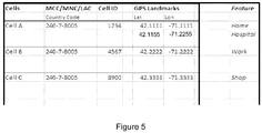
- FIG. 5 shows an example of the content of a geoprediction database in which details of the identified locations or landmarks are stored.
- Each identified location or landmark entry comprises the GPS position or positions (if multiple GPS position measurements have been obtained in a particular location) associated with the location or landmark, and the Cell_ID of the cell serving the mobile device 2 when at that location (i.e. the serving Cell_ID when the GPS position measurements were taken).
- the row marked 'Cell A' shows a unique Cell ID and a list of GPS positions considered to be important locations or landmarks corresponding to that cell, namely the GPS positions corresponding to the user's home and the hospital. These will be the locations where a search for the user will be started should GPS be unavailable and an alarm be triggered while the mobile device 2 is being served by Cell A.
- step 105 determines that multiple Cell_IDs are associated with a particular location (landmark), and in this case a particular location will be associated with each of those Cell_IDs in the database.
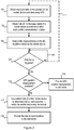
- step 107 it is determined where the button 4 has been activated or an alarm otherwise initiated. If not, the process waits until an alarm is triggered (indicated by line 109). Alternatively, or in addition, the process can return to step 101 to allow further position and Cell_ID measurements to be made (indicated by line 111), which means the geoprediction database can be constantly updated to reflect the current or typical behavior of the user.
- step 113 it is determined whether it is possible to measure the position of the mobile device 2 using GPS (step 113). If it is possible, a GPS position measurement is made and provided to the call centre.
- the mobile device 2 determines the identity of the cell serving the mobile device 2 and queries the geoprediction database with this Cell_ID to determine if there are any important or frequently visited locations (landmarks) associated with that Cell_ID.
- the mobile device 2 can extract the GPS position information for those positions and send this to the call centre (step 119). It will be appreciated that this information can be sent with an appropriate flag or other identifier that indicates to the call centre that this position information is an estimate or prediction based on the information in the geoprediction database.
- the position data can be sent to the call centre in the form of a text or multimedia message, or over a 2G, 3G or 4G data connection established between the mobile device 2 and the network.
- each entry in the database can include information on the time of day during which the user is typically at that location. This information can be recorded when each position measurement is obtained. For example, a recorded location corresponding to the place of work of the user may be associated with the times 8am to 5pm on weekdays, and a recorded location corresponding to a restaurant in the same cell could be associated with the times 8pm to 10pm on a weekend.
- the mobile device 2 can compare the current time to the multiple locations and provide information on the most likely one to the call centre (or alternatively order the provided locations in order of likelihood).
- the mobile device 2 can use the currently measured signal strength and Cell_ID to query the database for the relevant identified locations.
- the measured signal strength can help to differentiate between multiple locations for a particular Cell_ID.
- the mobile device 2 can collect and store information on the strength of signals received from neighboring cells (i.e. cells that were not serving the mobile device 2 at the time that the GPS position measurement was taken - including cells forming part of networks operated by different network providers), and corresponding information can be collected and used to query the database to filter the multiple locations for the serving Cell_ID.
- neighboring cells i.e. cells that were not serving the mobile device 2 at the time that the GPS position measurement was taken - including cells forming part of networks operated by different network providers
- This embodiment can be further enhanced by using the measurements of the strength of signals received from the serving base station and the neighboring cells to determine an approximate position of the mobile device 2 by triangulation.
- the triangulated position can be compared to the GPS measurements associated with the locations identified for the serving Cell_ID in the database.
- Other information that can be measured or obtained by the mobile device 2 and used to identify and distinguish between multiple landmarks within a cell can include temperature, sound, available WiFi networks and camera images.
- the method in Figure 2 is broadly split into two parts, the first part, corresponding to steps 101, 103 and 105, relates to generating a database of locations (landmarks) visited by the user and mobile device 2, and the second part, corresponding to steps 107, 109, 111, 113 and 115, relates to the use of the information in the database to provide location information to the call centre when a button 4 or an alarm is activated.
- this split is merely for the purposes of illustrating the invention, and the generation and maintenance of the database is an ongoing process.
- the database is created and maintained in the mobile device 2, it is possible for the database to be created and maintained in a remote server, which, for example, can be located at the call centre, and the mobile device 2 can simply provide the Cell_ID to the call centre if a GPS position measurement is unavailable, and the database in the server at the call centre can be queried using the received Cell_ID to determine a possible location for the user.
- a remote server which, for example, can be located at the call centre, and the mobile device 2 can simply provide the Cell_ID to the call centre if a GPS position measurement is unavailable, and the database in the server at the call centre can be queried using the received Cell_ID to determine a possible location for the user.
- the mobile device 2 can provide the most recent GPS position measurement (or a plurality of the most recent GPS position measurements) with the Cell_ID in step 117.
- the call centre can be provided with the last known accurate position or positions of the mobile device 2 and the possible location or locations (landmarks) in that cell for the user.
- the call centre personnel may be able to deduce the best location to start looking for the user.
- the mobile device 2 can reduce the frequency with which further GPS position measurements are taken in order to reduce the power consumption of the mobile device 2.
- the frequency can be returned to the normal level once the mobile device 2 determines that it is no longer proximate to a known landmark.
- this invention provides an extension to existing mobile PERS devices 2 to assist in providing useful location information for the user even when the main location technology, e.g. GPS, is unavailable.
- the invention can be implemented entirely on the mobile device 2 itself, and does not require an active voice or data connection to the network in order to build the database.
Landscapes
- Engineering & Computer Science (AREA)
- Radar, Positioning & Navigation (AREA)
- Remote Sensing (AREA)
- Physics & Mathematics (AREA)
- General Physics & Mathematics (AREA)
- Computer Networks & Wireless Communication (AREA)
- Signal Processing (AREA)
- Mobile Radio Communication Systems (AREA)
- Position Fixing By Use Of Radio Waves (AREA)
Description
- The invention relates to a method for estimating the location of a mobile device and a mobile device implementing the same, particularly where an accurate position of the mobile device using a satellite-based positioning system is unavailable.
- Falls are one of the greatest health risk factors for elderly people. About one third of older people above the age of 65 fall at least once a year.
- Many elderly people now carry personal help buttons (PHBs) or personal emergency response systems (PERS) that they can activate if they need urgent assistance, such as when they fall. Automated fall detectors are also available that monitor the movements of the user and automatically trigger an alarm if a fall is detected.
- These devices (i.e. PHBs, PERS and fall detectors) can initiate a landline call via a base unit located nearby to the user (i.e. typically in the user's home) to a call centre when they are activated, and the personnel in the call centre can talk to the user and arrange for assistance to be sent to the user in an emergency. As the user is a registered subscriber to the PHB/PERS service, their home location (or other location where the base station is found) will be known, and the emergency assistance can be directed to that location by the call centre personnel.
- However, systems are now available that make use of a mobile telephone or other mobile telecommunications-enabled device carried by the user to allow the PHB, PERS or fall detector device to initiate a mobile call to the call centre. As these devices can be used anywhere where there is cellular network coverage, it is necessary for information on the location of the user to be provided to the call centre when an alarm is triggered. This information should be provided automatically, since the user may be unresponsive (i.e. they may have fallen and are unconscious). Typically, this location information is derived using a Global Positioning System (GPS) receiver in the mobile device.
- However, when the user is indoors or otherwise out of sight of the required satellites, reliable position information is not available to the call centre.
-
US 2010/0194631 describes a method of determining the location of a portable device that uses GPS when it is available, and triangulation using information on cell towers when GPS is not available. This technique allows the location of a portable device to be estimated whenever a user has network coverage. At best, cell tower triangulation (or similar techniques such as cell tower fingerprinting) can provide a location for the user to an accuracy of around 50 meters, although this depends on favorable network topology and having multiple cell towers in range of the user. A typical figure is much higher, e.g. 200 meters. This accuracy may not be sufficient to locate the user to the correct location or building in an emergency situation.WO 201/015854 A1 -
WO 2010/003898 A1 discloses periodically measuring the position of a mobile device by GPS. Geographical areas such as cells of a communciation network in which the user spends a significant amount of time are identified and their cell IDs are stored. The system also stores in a memory, for each geographical area, the average GPS location before the loss of the GPS signal. In a case of need, this estimated position can be used for locating the mobile apparatus. - Therefore, there is a need for an alternative technique for determining the location of the user when GPS or other satellite-based positioning systems are unavailable.
- According to a first aspect of the invention, there is provided a method according to claim 1. In one embodiment, the step of analyzing the measurements to identify landmarks comprises identifying clusters in the measurements of the position of the mobile device; and identifying each identified cluster as a landmark. In a further embodiment, the step of analyzing the measurements to identify landmarks comprises identifying a journey undertaken by the user from consecutive measurements of the position of the user; and identifying the end point of the journey as a landmark.
- In one implementation, the end point of the journey corresponds to a point at which it becomes not possible to use the satellite-based positioning system to measure the position of the mobile device. In addition, or alternatively, the end point of the journey corresponds to a point at which a movement sensor in the mobile device indicates that the mobile device is no longer moving.
- In a further embodiment, the step of analyzing the measurements to identify landmarks comprises identifying a location as corresponding to a first measurement of the position of the mobile device obtained after a period of time during which the mobile device is stationary.
- In some embodiments, the method further comprises the step of noting the time at which each measurement of the position of the mobile device is obtained; wherein the step of analyzing the measurements to identify landmarks
further comprises identifying the times at which the mobile device is at each landmark; and wherein the step of estimating the location of the mobile device uses the current time and identity of the base station by which the mobile station is currently served. In this way, it is possible to determine which one of multiple locations within the coverage area of a particular base station the user is most likely to be found, based on the time of day that the user is normally found at that location. - In some embodiments, the method further comprises the step of obtaining measurements of the strength of signals received from the base station serving the mobile device at the time of each measurement of the position of the mobile device; wherein the step of analyzing the measurements to identify landmarks further comprises identifying the measured signal strength when the mobile device is at each landmark; and wherein the step of estimating the location of the mobile device uses the identity and current measured signal strength of the base station by which the mobile station is currently served. This embodiment provides another way to determine which one of multiple locations within the coverage area of a particular base station the user is most likely to be found.
- The step of estimating the location of the mobile device can comprise estimating the location of the mobile device using a recent measurement of the position of the mobile device and the one or more identified landmarks that are associated with the base station by which the mobile device is currently served. This embodiment provides yet another way to determine which one of multiple locations within the coverage area of a particular base station the user is most likely to be found.
- Preferably, the step of estimating the location of the mobile device is performed after a user of the mobile device triggers an alarm or an alarm is otherwise triggered by the mobile device. In this case, the method preferably further comprises sending information on the one or more identified landmarks that are associated with the base station by which the mobile device is currently served from the mobile device to a remote location.
- According to a second aspect of the invention, there is provided an apparatus according to
claim 12. Preferred implementations are defined by the dependent claims. According to a third aspect of the invention, there is provided a computer program product according toclaim 15. - Embodiments of the invention will now be described, by way of example only, with reference to the following drawings, in which:
-
Fig. 1 is a block diagram of a mobile personal emergency response system (PERS) device in accordance with the invention; -
Fig. 2 is a flow chart illustrating a method according to an embodiment of the invention; -
Fig. 3 is a diagram illustrating GPS data collected by a mobile PERS device on a map; -
Fig. 4 is a diagram illustrating the identification of landmarks in the GPS data shown inFig. 3 ; and -
Fig. 5 is a table illustrating the content of an exemplary geoprediction database according to the invention. - An exemplary mobile personal emergency response system (PERS)
device 2 is shown inFigure 1 . Thedevice 2 comprises abutton 4 that can be activated by the user when they require assistance, anaudible alarm unit 6 that can be used to summon the assistance of someone in the vicinity of the user when thebutton 4 is activated, aloudspeaker 7,transceiver circuitry 8 and associatedantenna 10 for initiating a call to a call centre over a cellular telecommunication network, amicrophone 11 and aGPS receiver 12 and associatedantenna 14 for determining the location of themobile PERS device 2 from received GPS signals. - The
mobile PERS device 2 also comprises aprocessor 16 that is connected to thebutton 4,alarm 6,loudspeaker 7,transceiver circuitry 8, microphone 11 andGPS receiver 12, and that controls the operation of thedevice 2. Themobile PERS device 2 also comprises amemory 18 that is connected to theprocessor 16, and that can store, for example, code to be executed by theprocessor 16 to control the operation of thedevice 2, location information provided by theGPS receiver 12 and other information collected in accordance with the invention, as described further below. - It will be appreciated that the
mobile PERS device 2 shown inFigure 1 is merely exemplary, and may take alternative forms without affecting the operation of the invention. For example, themobile PERS device 2 can comprise a conventional mobile telephone, a smartphone or other mobile telecommunications-enabled device (such as personal digital assistant (PDA), laptop or tablet computer, etc.) and a separate device (such as a PHB) having a button that can be activated by the user, with the devices being paired together in a wired or wireless manner (for example using WiFi or Bluetooth). - The
mobile PERS device 2 may make use of a further or alternative satellite-based positioning system to GPS, as known to those skilled in the art. - The
button 4 may advantageously be a physical button on thedevice 2, although it will be appreciated that it can be implemented as a function that can be selected through the use of a keyboard or touch screen user interface in thedevice 2. - It will also be appreciated that where the
mobile PERS device 2 is used to monitor the movement of the user, for example to detect a fall, thedevice 2 can comprise one or more sensors, for example an accelerometer, an air pressure sensor, a magnetometer, and/or a gyroscope, and this information may also be used to generate a help call. - As known, in the event of an emergency, the user can press or otherwise activate the
button 4, which will trigger a call to a call centre. In order for the call centre personnel to be able to direct the emergency assistance to the appropriate location, GPS position information is acquired using theGPS receiver 12 in thedevice 2 after thebutton 4 is activated, and this position information is provided to the call centre during the call. - However, when GPS signals are unavailable, for example when the user is indoors or otherwise does not have line-of-sight to a sufficient number of satellites, it is not possible to provide this position information to the call centre.
- Therefore, in accordance with the invention, a mapping between the Cell_ID (the identity of a network cell that is serving the mobile device 2), which is always available when the
device 2 is able to make a call, and GPS positions (which are currently the best type of location measurement) is created. - By analyzing the GPS positions of the user/
mobile device 2 over a period of time (for example several days), it is possible to identify locations that have been recently or previously visited by the user, and/or are frequently visited by the user, and can therefore be considered to be important. Each important location (denoted a "landmark" herein) is stored in a database together with the Cell_ID of the cell tower serving thedevice 2 when thedevice 2 is at that location (i.e. the Cell_ID of the tower serving thedevice 2 when the GPS position measurements were taken). - Subsequently, when the user activates their
button 4, call centre personnel will first attempt to verify the safety and location of the user by voice communication and GPS location measurements. If this approach fails (for example if GPS is unavailable), the database can be queried using the serving Cell_ID to determine if there are any landmarks associated with that cell. If one or more landmarks are identified, the GPS coordinates of those landmarks can then be sent to the call centre by thedevice 2. - As typical cells can vary in radius from 500m to 30km, an emergency responder can be directed to the one or more landmarks within that cell, and this can reduce the time taken to find the user.
- An exemplary method in accordance with the invention is shown in
Figure 2 . Instep 101, measurements of the position of thedevice 2 are taken using theGPS receiver 12. In order to preserve the battery life of thedevice 2, measurements are not taken continuously, but instead they are taken at periodic intervals, for example every 10 seconds, every minute, or every few (e.g. 5) minutes. As discussed further below, the interval between measurements can be varied depending on the activity of themobile device 2, as measured by a movement sensor, such as an accelerometer. For example, if the movement sensor indicates that themobile device 2 is not moving, the interval between measurements can be relatively long, whereas the interval can be much shorter (e.g. every few seconds or minutes) when the movement sensor indicates that themobile device 2 is moving. -
Figure 3 shows an exemplary set ofGPS position measurements 30 plotted on a map. These measurements have been collected while themobile device 2 is being used in an area that is local to the home of the user. - In
step 103, the serving Cell_ID for themobile device 2 is identified each time that a position measurement is taken. Mobile phone standards such as GSM, CDMA and UMTS require as a part of their specification that the transceiver in mobile devices can be interrogated directly to determine the base station identity, Cell_ID, and those skilled in the art will be aware of techniques for obtaining this information. - Each position measurement and associated Cell_ID are stored in the
memory 18 of thedevice 2. The time at which the position measurement is taken can also be stored with the relevant position measurement and Cell_ID in thememory 18. - It will be appreciated that the location of the home of the user (perhaps in terms of a GPS position) will be known through the registration of the user with the PERS service. The home of the exemplary user in
Figure 3 is labeled withreference numeral 32. As themobile PERS device 2 may make use of a base unit when the user is at home (therefore negating the need for a position measurement to be taken by themobile device 2 when an alarm is triggered), position measurements taken instep 101 that correspond to the home location of the user may be discarded (i.e. not stored in the memory 18) in order to reduce the size of the dataset to be stored and analyzed. - Once a number of position measurements and Cell_IDs have been collected, for example over a period of hours, days or weeks, or once a predetermined number of position measurements have been collected, the measurements can be analyzed to identify if there are any locations frequently or regularly visited by the mobile device 2 (step 105).
- The objective of
analysis step 105 is to identify particular locations that the user has visited from the stored GPS data. Locations which are visited frequently are probably important locations and worth recording. - Step 105 can comprise identifying clusters of GPS position measurements, with each identified cluster being considered to be an important location for the user. A cluster can be identified by the proximity of a plurality of position measurements to each other. A cluster can also be identified as a location worth noting by examining whether the user has visited that location on more than one occasion, for example by comparing the time (and date) of the position measurements in a cluster.
- Clustering can be performed using simple k-means clustering of locations, or a hidden Markov model or Bayesian network could be used to create a probability distribution of locations in time. Those skilled in the art will be aware of other algorithms and techniques that can be used to perform this clustering.
-
Figure 4 shows the result of applying a clustering algorithm to the position measurements illustrated inFigure 3 , where it can be seen that twoclusters Figure 4 also shows the approximate areas covered by three cells, and it can be seen thatcluster 34a is within the coverage area of a cell A andcluster 34b is within the coverage area of a cell C. - Step 105 can also or alternatively comprise identifying particular trips or journeys undertaken by the user from consecutive measurements of the position of the
device 2. A tracking algorithm can be used to identify a single trip taken by the user, such as that indicated byroute 36 with an end point (destination) 38. It can be assumed that the endpoint of this path is an important location and therefore is worth recording. Those skilled in the art will be aware of algorithms and techniques for identifying these trips or journeys from the position measurements. InFigure 4 , it can be seen that theend point 38 ofroute 36 is found within cell B. - In some implementations, the end point may be identified by the
device 2 no longer being unable to measure its position using GPS, for example due to thedevice 2 being taken indoors. Alternatively, another sensor in the device 2 (such as an accelerometer) may indicate that a journey has ended by a lack of movement of thedevice 2 being detected. - An additional or alternative way of identifying important locations is to activate the
GPS receiver 12 when activity (i.e. motion of the device 2) is detected after a long stationary period. If it is not possible to measure the position of thedevice 2 using GPS straight away (or within a suitable time window to allow for thedevice 2 to obtain a GPS position measurement), theGPS receiver 12 can be left on for a period of time until a position measurement is obtained. This position measurement can be interpreted as the user andmobile device 2 leaving a building. This position measurement can therefore be considered as a landmark, which is associated with a Cell_ID, thereby allowing the building to be properly identified the next time the user visits. -
Figure 5 shows an example of the content of a geoprediction database in which details of the identified locations or landmarks are stored. Each identified location or landmark entry comprises the GPS position or positions (if multiple GPS position measurements have been obtained in a particular location) associated with the location or landmark, and the Cell_ID of the cell serving themobile device 2 when at that location (i.e. the serving Cell_ID when the GPS position measurements were taken). - Thus, in
Figure 5 , the row marked 'Cell A' shows a unique Cell ID and a list of GPS positions considered to be important locations or landmarks corresponding to that cell, namely the GPS positions corresponding to the user's home and the hospital. These will be the locations where a search for the user will be started should GPS be unavailable and an alarm be triggered while themobile device 2 is being served by Cell A. - It will be appreciated that it is possible for the result of the analysis in
step 105 to determine that multiple Cell_IDs are associated with a particular location (landmark), and in this case a particular location will be associated with each of those Cell_IDs in the database. - Returning to
Figure 2 , instep 107, it is determined where thebutton 4 has been activated or an alarm otherwise initiated. If not, the process waits until an alarm is triggered (indicated by line 109). Alternatively, or in addition, the process can return to step 101 to allow further position and Cell_ID measurements to be made (indicated by line 111), which means the geoprediction database can be constantly updated to reflect the current or typical behavior of the user. - If an alarm is triggered, it is determined whether it is possible to measure the position of the
mobile device 2 using GPS (step 113). If it is possible, a GPS position measurement is made and provided to the call centre. - If it is not possible to measure the position of the
mobile device 2 using GPS, themobile device 2 determines the identity of the cell serving themobile device 2 and queries the geoprediction database with this Cell_ID to determine if there are any important or frequently visited locations (landmarks) associated with that Cell_ID. - If one or more locations are found in the database for that Cell_ID, the
mobile device 2 can extract the GPS position information for those positions and send this to the call centre (step 119). It will be appreciated that this information can be sent with an appropriate flag or other identifier that indicates to the call centre that this position information is an estimate or prediction based on the information in the geoprediction database. The position data can be sent to the call centre in the form of a text or multimedia message, or over a 2G, 3G or 4G data connection established between themobile device 2 and the network. - Where there are multiple locations in the database for that Cell_ID, it is possible to use further information in order to identify the location the user is most likely to be at. In one embodiment, each entry in the database can include information on the time of day during which the user is typically at that location. This information can be recorded when each position measurement is obtained. For example, a recorded location corresponding to the place of work of the user may be associated with the times 8am to 5pm on weekdays, and a recorded location corresponding to a restaurant in the same cell could be associated with the times 8pm to 10pm on a weekend. In extracting the estimated location information from the database, the
mobile device 2 can compare the current time to the multiple locations and provide information on the most likely one to the call centre (or alternatively order the provided locations in order of likelihood). - In a further or alternative embodiment, if the
mobile device 2 has collected and stored information on the strength of the signals received at themobile device 2 from the base station (which can be collected when each GPS position measurement is taken), themobile device 2 can use the currently measured signal strength and Cell_ID to query the database for the relevant identified locations. The measured signal strength can help to differentiate between multiple locations for a particular Cell_ID. - As a further enhancement, the
mobile device 2 can collect and store information on the strength of signals received from neighboring cells (i.e. cells that were not serving themobile device 2 at the time that the GPS position measurement was taken - including cells forming part of networks operated by different network providers), and corresponding information can be collected and used to query the database to filter the multiple locations for the serving Cell_ID. - This embodiment can be further enhanced by using the measurements of the strength of signals received from the serving base station and the neighboring cells to determine an approximate position of the
mobile device 2 by triangulation. The triangulated position can be compared to the GPS measurements associated with the locations identified for the serving Cell_ID in the database. - Other information that can be measured or obtained by the
mobile device 2 and used to identify and distinguish between multiple landmarks within a cell can include temperature, sound, available WiFi networks and camera images. - It will be appreciated that the method in
Figure 2 is broadly split into two parts, the first part, corresponding tosteps mobile device 2, and the second part, corresponding tosteps button 4 or an alarm is activated. It will be appreciated, however, that this split is merely for the purposes of illustrating the invention, and the generation and maintenance of the database is an ongoing process. - It will also be appreciated that although in the embodiment described and illustrated above the database is created and maintained in the
mobile device 2, it is possible for the database to be created and maintained in a remote server, which, for example, can be located at the call centre, and themobile device 2 can simply provide the Cell_ID to the call centre if a GPS position measurement is unavailable, and the database in the server at the call centre can be queried using the received Cell_ID to determine a possible location for the user. - In a further embodiment, the
mobile device 2 can provide the most recent GPS position measurement (or a plurality of the most recent GPS position measurements) with the Cell_ID instep 117. This way, the call centre can be provided with the last known accurate position or positions of themobile device 2 and the possible location or locations (landmarks) in that cell for the user. By plotting the potential landmarks and the most recent GPS position measurement(s) on a map, the call centre personnel may be able to deduce the best location to start looking for the user. - In a yet further embodiment, if the
mobile device 2 determines that it is proximate to a known landmark stored in the database (for example by comparing a newly acquired GPS position measurement to the database entries), themobile device 2 can reduce the frequency with which further GPS position measurements are taken in order to reduce the power consumption of themobile device 2. The frequency can be returned to the normal level once themobile device 2 determines that it is no longer proximate to a known landmark. - Thus, this invention provides an extension to existing
mobile PERS devices 2 to assist in providing useful location information for the user even when the main location technology, e.g. GPS, is unavailable. The invention can be implemented entirely on themobile device 2 itself, and does not require an active voice or data connection to the network in order to build the database. - There is therefore provided a technique for determining the location of a user when GPS or other satellite-based positioning systems are unavailable.
- While the invention has been illustrated and described in detail in the drawings and foregoing description, such illustration and description are to be considered illustrative or exemplary and not restrictive; the invention is not limited to the disclosed embodiments.
Claims (15)
- A method of estimating the location of a mobile device, the mobile device being configured for use in a cellular mobile communications network comprising a plurality of base stations, the method comprising:generating a database of landmarks visited by the mobile device by:obtaining measurements of the position of the mobile device over a period of time using a satellite-based positioning system;obtaining the identity of the base station serving the mobile device at the time of each measurement of the position of the mobile device; andanalyzing the measurements obtained over said period of time to identify landmarks, wherein a landmark is a location which is frequently or regularly visited by the mobile device; andstoring each identified landmark in the database, whereby each landmark entry comprises the position measurements associated with said landmark, and the identity of the base station serving said mobile device when at said landmark; andduring subsequent use of the mobile device, in the event that it is not possible to use the satellite-based positioning system to measure the position of the mobile device, estimating the location of the mobile device as one or more identified landmarks that are associated with the base station by which the mobile device is currently served.
- A method as claimed in claim 1, wherein the step of analyzing the measurements to identify landmarks comprises:identifying clusters in the measurements of the position of the mobile device; andidentifying each identified cluster as a landmark.
- A method as claimed in claim 1 or 2, wherein the step of analyzing the measurements to identify landmarks comprises:identifying a journey undertaken by the user from consecutive measurements of the position of the user; andidentifying the end point of the journey as a landmark.
- A method as claimed in claim 3, wherein the end point of the journey corresponds to a point at which it becomes not possible to use the satellite-based positioning system to measure the position of the mobile device.
- A method as claimed in claim 3 or 4, wherein the end point of the journey corresponds to a point at which a movement sensor in the mobile device indicates that the mobile device is no longer moving.
- A method as claimed in any preceding claim, wherein the step of analyzing the measurements to identify landmarks comprises identifying a landmark as corresponding to a first measurement of the position of the mobile device obtained after a period of time during which the mobile device is stationary.
- A method as claimed in any preceding claim, further comprising the step of:noting the time at which each measurement of the position of the mobile device is obtained;wherein the step of analyzing the measurements to identify landmarks further comprises identifying the times at which the mobile device is at each landmark; andwherein the step of estimating the location of the mobile device uses the current time and identity of the base station by which the mobile station is currently served.
- A method as claimed in any preceding claim, further comprising the step of:obtaining measurements of the strength of signals received from the base station serving the mobile device at the time of each measurement of the position of the mobile device;wherein the step of analyzing the measurements to identify landmarks further comprises identifying the measured signal strength when the mobile device is at each landmark; andwherein the step of estimating the location of the mobile device uses the identity and current measured signal strength of the base station by which the mobile station is currently served.
- A method as claimed in any preceding claim, wherein the step of estimating the location of the mobile device comprises estimating the location of the mobile device using a recent measurement of the position of the mobile device and the one or more identified landmarks that are associated with the base station by which the mobile device is currently served.
- A method as claimed in any preceding claim, wherein the step of estimating the location of the mobile device is performed after a user of the mobile device triggers an alarm or an alarm is otherwise triggered by the mobile device.
- A method as claimed in any preceding claim, further comprising the step of sending information on the one or more identified landmarks that are associated with the base station by which the mobile device is currently served
from the mobile device to a remote location. - An apparatus, comprising:a processor that is configured to:receive measurements of the position of a mobile device obtained over a period of time using a satellite-based positioning system;determine the identity of a base station in a cellular telecommunications network serving the mobile device at the time of each measurement of the position of the mobile device;analyze the measurements obtained over said period of time to identify landmarks, wherein a landmark is a location which is frequently or regularly visited by the mobile device; andstore, in a memory connected to the processor, each identified landmark, whereby each landmark entry comprises the position measurements associated with said landmark, and the identity of the base station serving said mobile device when at said landmark; andduring subsequent use of the mobile device, in the event that it is not possible to determine a measurement of the position of the mobile device using the satellite-based positioning system, estimate the location of the mobile device as one or more identified landmarks that are associated with the base station by which the mobile device is currently served.
- An apparatus as claimed in claim 12, wherein the apparatus is the mobile device.
- An apparatus as claimed in claim 12, wherein the apparatus is a server that is configured to communicate with the mobile device.
- A computer program product, comprising computer program code that, when executed on a suitable computer or processor, is configured to cause the computer or processor to perform the method as claimed in any of claims 1 to 11.
Priority Applications (1)
| Application Number | Priority Date | Filing Date | Title |
|---|---|---|---|
| EP12740209.7A EP2726898B1 (en) | 2011-06-29 | 2012-06-21 | Location estimation for a mobile device |
Applications Claiming Priority (3)
| Application Number | Priority Date | Filing Date | Title |
|---|---|---|---|
| EP11171854 | 2011-06-29 | ||
| PCT/IB2012/053129 WO2013001421A1 (en) | 2011-06-29 | 2012-06-21 | Location estimation for a mobile device |
| EP12740209.7A EP2726898B1 (en) | 2011-06-29 | 2012-06-21 | Location estimation for a mobile device |
Publications (2)
| Publication Number | Publication Date |
|---|---|
| EP2726898A1 EP2726898A1 (en) | 2014-05-07 |
| EP2726898B1 true EP2726898B1 (en) | 2017-08-09 |
Family
ID=46582027
Family Applications (1)
| Application Number | Title | Priority Date | Filing Date |
|---|---|---|---|
| EP12740209.7A Active EP2726898B1 (en) | 2011-06-29 | 2012-06-21 | Location estimation for a mobile device |
Country Status (6)
| Country | Link |
|---|---|
| US (1) | US20140120950A1 (en) |
| EP (1) | EP2726898B1 (en) |
| JP (1) | JP6088504B2 (en) |
| CN (1) | CN103649770B (en) |
| ES (1) | ES2645771T3 (en) |
| WO (1) | WO2013001421A1 (en) |
Families Citing this family (14)
| Publication number | Priority date | Publication date | Assignee | Title |
|---|---|---|---|---|
| US9244152B1 (en) * | 2012-06-01 | 2016-01-26 | Amazon Technologies, Inc. | Determining device locations using movement, signal strength |
| US20150005007A1 (en) * | 2013-06-28 | 2015-01-01 | Streetlight Data, Inc. | Displaying demographic data |
| US10043365B2 (en) | 2013-10-25 | 2018-08-07 | Beijing Qihoo Technology Company Limited | Position information prompting method, device and system |
| CN103561464B (en) * | 2013-10-25 | 2017-04-19 | 北京奇宝科技有限公司 | Position information prompting method, device and system |
| US9470796B2 (en) * | 2014-04-23 | 2016-10-18 | Opentv, Inc. | Techniques for securing live positioning signals |
| US9277526B2 (en) * | 2014-05-06 | 2016-03-01 | Telecommunication Systems, Inc. | Location trust score |
| WO2016206650A1 (en) | 2015-06-25 | 2016-12-29 | 华为技术有限公司 | Uplink data transmission method and apparatus |
| CN107850659A (en) * | 2015-06-29 | 2018-03-27 | 赫尔环球有限公司 | Support to position the mobile device by mobile device |
| KR101631121B1 (en) * | 2015-08-18 | 2016-06-27 | 주식회사 아이쉐어링소프트 | Method of measuring a location of mobile computing device and mobile computing device performing the same |
| US10429190B2 (en) * | 2016-11-08 | 2019-10-01 | Ford Global Technologies, Llc | Vehicle localization based on wireless local area network nodes |
| CN110019329B (en) * | 2017-07-31 | 2021-11-05 | 广州极飞科技股份有限公司 | Data prediction method and device |
| EP4014063A1 (en) * | 2019-08-14 | 2022-06-22 | Huawei Technologies Co., Ltd. | Devices and methods for automatically labelling high accuracy indoor localization and determining location information |
| EP3822935A1 (en) * | 2019-11-13 | 2021-05-19 | Carrier Corporation | A method and a system for enabling user/s to trigger an alarm |
| EP4175351A4 (en) * | 2020-06-28 | 2024-03-27 | Beijing Xiaomi Mobile Software Co., Ltd. | MEASURING METHOD, BASE STATION, MULTI-MODE TERMINAL, COMMUNICATION DEVICE AND STORAGE MEDIUM |
Citations (1)
| Publication number | Priority date | Publication date | Assignee | Title |
|---|---|---|---|---|
| WO2010003898A1 (en) * | 2008-07-08 | 2010-01-14 | Gilles Rooss | Environment-driven adaptive geolocation system |
Family Cites Families (22)
| Publication number | Priority date | Publication date | Assignee | Title |
|---|---|---|---|---|
| JP2001119742A (en) * | 1999-10-19 | 2001-04-27 | Hitachi Ltd | Mobile station device and network device in mobile communication |
| US6433735B1 (en) * | 2000-12-26 | 2002-08-13 | Telefonaktiebolaget (Lme) | Mobile terminal and system and method for determining the geographic location of a mobile terminal |
| JP3920727B2 (en) * | 2002-07-16 | 2007-05-30 | 富士フイルム株式会社 | Portable communication device |
| US6774842B2 (en) * | 2002-12-03 | 2004-08-10 | Nokia Corporation | Generating entries for a database supporting a positioning of a mobile terminal |
| EP1700133A1 (en) * | 2003-12-31 | 2006-09-13 | France Telecom | Technique for collecting and using information about the geographic position of a mobile object on the earth's surface |
| CN100378717C (en) * | 2004-01-17 | 2008-04-02 | 华为技术有限公司 | A method for obtaining the direction of a target location through a handheld device |
| US7397424B2 (en) * | 2005-02-03 | 2008-07-08 | Mexens Intellectual Property Holding, Llc | System and method for enabling continuous geographic location estimation for wireless computing devices |
| US8024112B2 (en) * | 2005-09-29 | 2011-09-20 | Microsoft Corporation | Methods for predicting destinations from partial trajectories employing open-and closed-world modeling methods |
| JP2007151104A (en) * | 2005-11-04 | 2007-06-14 | G Force:Kk | Wireless portable terminal and location information notification / search system in emergency situations |
| FR2896655B1 (en) * | 2006-01-26 | 2008-10-03 | Bouygues Telecom Sa | METHOD FOR LOCATING A MOBILE TERMINAL |
| JP2007228018A (en) * | 2006-02-21 | 2007-09-06 | Matsushita Electric Works Ltd | Emergency call terminal |
| US9044136B2 (en) * | 2007-02-16 | 2015-06-02 | Cim Technology Inc. | Wearable mini-size intelligent healthcare system |
| JP2008305098A (en) * | 2007-06-06 | 2008-12-18 | Hitachi Ltd | Dynamic management system, dynamic management method, and dynamic management program |
| WO2008157736A1 (en) * | 2007-06-19 | 2008-12-24 | Qualcomm Incorporated | Methods and apparatus for determining distances to selected targets on a golf course using a wireless communication device |
| JP5077678B2 (en) * | 2008-02-25 | 2012-11-21 | Necカシオモバイルコミュニケーションズ株式会社 | Communication terminal device and program |
| GB2462592A (en) * | 2008-08-06 | 2010-02-17 | Geotate Bv | Supplementing GPS position information adaptively with WiFi location data |
| US8086250B2 (en) * | 2009-02-03 | 2011-12-27 | Integrity Tracking, Llc | Communications method |
| GB2469523B (en) * | 2009-04-17 | 2011-12-14 | Samsung Electronics Co Ltd | Position determination apparatus and method |
| US8433509B2 (en) * | 2009-04-17 | 2013-04-30 | Samsung Electronics Co., Ltd. | Position determination apparatus and method |
| WO2010126412A1 (en) * | 2009-04-28 | 2010-11-04 | Telefonaktiebolaget Lm Ericsson (Publ) | Predicting presence of a mobile user equipment |
| US8756010B2 (en) * | 2009-10-12 | 2014-06-17 | Qualcomm Incorporated | Method and apparatus for identification of points of interest within a predefined area |
| US8855676B2 (en) * | 2011-03-24 | 2014-10-07 | Sprint Spectrum L.P. | Method and apparatus for providing satellite assistance data |
-
2012
- 2012-06-21 EP EP12740209.7A patent/EP2726898B1/en active Active
- 2012-06-21 US US14/126,954 patent/US20140120950A1/en not_active Abandoned
- 2012-06-21 CN CN201280032131.7A patent/CN103649770B/en active Active
- 2012-06-21 ES ES12740209.7T patent/ES2645771T3/en active Active
- 2012-06-21 JP JP2014518002A patent/JP6088504B2/en active Active
- 2012-06-21 WO PCT/IB2012/053129 patent/WO2013001421A1/en active Application Filing
Patent Citations (1)
| Publication number | Priority date | Publication date | Assignee | Title |
|---|---|---|---|---|
| WO2010003898A1 (en) * | 2008-07-08 | 2010-01-14 | Gilles Rooss | Environment-driven adaptive geolocation system |
Also Published As
| Publication number | Publication date |
|---|---|
| WO2013001421A1 (en) | 2013-01-03 |
| CN103649770A (en) | 2014-03-19 |
| US20140120950A1 (en) | 2014-05-01 |
| ES2645771T3 (en) | 2017-12-07 |
| JP6088504B2 (en) | 2017-03-01 |
| JP2014524023A (en) | 2014-09-18 |
| CN103649770B (en) | 2016-08-24 |
| EP2726898A1 (en) | 2014-05-07 |
Similar Documents
| Publication | Publication Date | Title |
|---|---|---|
| EP2726898B1 (en) | Location estimation for a mobile device | |
| EP2867615B1 (en) | A method of estimating the position of a device and an apparatus implementing the same | |
| CN111788852B (en) | Method for supporting positioning of a wireless device, network node and wireless device | |
| US9019077B2 (en) | System and method for predicting future meetings of wireless users | |
| US8013746B2 (en) | Method of providing alarm service upon movement out of safety zone | |
| CN102112891B (en) | Robust location estimation | |
| US9058732B2 (en) | Method and apparatus for enhanced indoor position location with assisted user profiles | |
| CN105075335B (en) | Method and apparatus for cooperative localization in cordless communication network | |
| US9420424B2 (en) | System and method for measuring the crowdedness of people at a place | |
| CN100559893C (en) | A method, system and device for activating location-based functionality | |
| US20160094953A1 (en) | Mobile help buttons with multiple location technologies | |
| US20140274115A1 (en) | Tracking device and remote monitoring system | |
| KR20130047386A (en) | System and method for mersuring location in wireless communication terminal, method for collecting fingerprint information in wireless communication terminal, fingerprint server and method for providing location using the same | |
| CN104267090A (en) | A mobile terminal-based toxic gas detection method and device | |
| JP6804501B2 (en) | Methods and platforms for sending messages to communication devices associated with moving objects | |
| JP2013251718A (en) | Mobile communication device, communication method, and program | |
| KR101831250B1 (en) | System for operating location based service using fixed terminal-mobile terminal and method therefor | |
| JP5239608B2 (en) | MOBILE BODY MONITORING DEVICE, MOBILE BODY MONITORING METHOD, MOBILE BODY MONITORING SYSTEM, AND COMPUTER PROGRAM | |
| US20220167115A1 (en) | Setting an area of interest based on at least one set of radio signal observation results captured by a tracking device | |
| KR100919778B1 (en) | Apparatus and method for providing location data of mobile terminal | |
| JP2022082444A (en) | Determination whether tracking device is within target area based on at least one radio signal observation result set captured by the tracking device | |
| Nawarathne | Optimizing Battery Usage in Outdoor Location Based Applications |
Legal Events
| Date | Code | Title | Description |
|---|---|---|---|
| PUAI | Public reference made under article 153(3) epc to a published international application that has entered the european phase |
Free format text: ORIGINAL CODE: 0009012 |
|
| 17P | Request for examination filed |
Effective date: 20140129 |
|
| AK | Designated contracting states |
Kind code of ref document: A1 Designated state(s): AL AT BE BG CH CY CZ DE DK EE ES FI FR GB GR HR HU IE IS IT LI LT LU LV MC MK MT NL NO PL PT RO RS SE SI SK SM TR |
|
| DAX | Request for extension of the european patent (deleted) | ||
| RIC1 | Information provided on ipc code assigned before grant |
Ipc: G01S 19/17 20100101ALN20160630BHEP Ipc: G01S 19/46 20100101ALI20160630BHEP Ipc: G01S 5/02 20060101AFI20160630BHEP Ipc: H04W 4/02 20090101ALI20160630BHEP |
|
| GRAP | Despatch of communication of intention to grant a patent |
Free format text: ORIGINAL CODE: EPIDOSNIGR1 |
|
| INTG | Intention to grant announced |
Effective date: 20170125 |
|
| GRAS | Grant fee paid |
Free format text: ORIGINAL CODE: EPIDOSNIGR3 |
|
| GRAA | (expected) grant |
Free format text: ORIGINAL CODE: 0009210 |
|
| AK | Designated contracting states |
Kind code of ref document: B1 Designated state(s): AL AT BE BG CH CY CZ DE DK EE ES FI FR GB GR HR HU IE IS IT LI LT LU LV MC MK MT NL NO PL PT RO RS SE SI SK SM TR |
|
| REG | Reference to a national code |
Ref country code: GB Ref legal event code: FG4D |
|
| REG | Reference to a national code |
Ref country code: CH Ref legal event code: EP Ref country code: AT Ref legal event code: REF Ref document number: 917437 Country of ref document: AT Kind code of ref document: T Effective date: 20170815 |
|
| REG | Reference to a national code |
Ref country code: IE Ref legal event code: FG4D |
|
| REG | Reference to a national code |
Ref country code: DE Ref legal event code: R096 Ref document number: 602012035661 Country of ref document: DE |
|
| REG | Reference to a national code |
Ref country code: ES Ref legal event code: FG2A Ref document number: 2645771 Country of ref document: ES Kind code of ref document: T3 Effective date: 20171207 |
|
| REG | Reference to a national code |
Ref country code: NL Ref legal event code: MP Effective date: 20170809 |
|
| REG | Reference to a national code |
Ref country code: LT Ref legal event code: MG4D |
|
| REG | Reference to a national code |
Ref country code: AT Ref legal event code: MK05 Ref document number: 917437 Country of ref document: AT Kind code of ref document: T Effective date: 20170809 |
|
| PG25 | Lapsed in a contracting state [announced via postgrant information from national office to epo] |
Ref country code: NL Free format text: LAPSE BECAUSE OF FAILURE TO SUBMIT A TRANSLATION OF THE DESCRIPTION OR TO PAY THE FEE WITHIN THE PRESCRIBED TIME-LIMIT Effective date: 20170809 Ref country code: LT Free format text: LAPSE BECAUSE OF FAILURE TO SUBMIT A TRANSLATION OF THE DESCRIPTION OR TO PAY THE FEE WITHIN THE PRESCRIBED TIME-LIMIT Effective date: 20170809 Ref country code: FI Free format text: LAPSE BECAUSE OF FAILURE TO SUBMIT A TRANSLATION OF THE DESCRIPTION OR TO PAY THE FEE WITHIN THE PRESCRIBED TIME-LIMIT Effective date: 20170809 Ref country code: SE Free format text: LAPSE BECAUSE OF FAILURE TO SUBMIT A TRANSLATION OF THE DESCRIPTION OR TO PAY THE FEE WITHIN THE PRESCRIBED TIME-LIMIT Effective date: 20170809 Ref country code: NO Free format text: LAPSE BECAUSE OF FAILURE TO SUBMIT A TRANSLATION OF THE DESCRIPTION OR TO PAY THE FEE WITHIN THE PRESCRIBED TIME-LIMIT Effective date: 20171109 Ref country code: AT Free format text: LAPSE BECAUSE OF FAILURE TO SUBMIT A TRANSLATION OF THE DESCRIPTION OR TO PAY THE FEE WITHIN THE PRESCRIBED TIME-LIMIT Effective date: 20170809 Ref country code: HR Free format text: LAPSE BECAUSE OF FAILURE TO SUBMIT A TRANSLATION OF THE DESCRIPTION OR TO PAY THE FEE WITHIN THE PRESCRIBED TIME-LIMIT Effective date: 20170809 |
|
| PG25 | Lapsed in a contracting state [announced via postgrant information from national office to epo] |
Ref country code: PL Free format text: LAPSE BECAUSE OF FAILURE TO SUBMIT A TRANSLATION OF THE DESCRIPTION OR TO PAY THE FEE WITHIN THE PRESCRIBED TIME-LIMIT Effective date: 20170809 Ref country code: RS Free format text: LAPSE BECAUSE OF FAILURE TO SUBMIT A TRANSLATION OF THE DESCRIPTION OR TO PAY THE FEE WITHIN THE PRESCRIBED TIME-LIMIT Effective date: 20170809 Ref country code: GR Free format text: LAPSE BECAUSE OF FAILURE TO SUBMIT A TRANSLATION OF THE DESCRIPTION OR TO PAY THE FEE WITHIN THE PRESCRIBED TIME-LIMIT Effective date: 20171110 Ref country code: IS Free format text: LAPSE BECAUSE OF FAILURE TO SUBMIT A TRANSLATION OF THE DESCRIPTION OR TO PAY THE FEE WITHIN THE PRESCRIBED TIME-LIMIT Effective date: 20171209 Ref country code: LV Free format text: LAPSE BECAUSE OF FAILURE TO SUBMIT A TRANSLATION OF THE DESCRIPTION OR TO PAY THE FEE WITHIN THE PRESCRIBED TIME-LIMIT Effective date: 20170809 Ref country code: BG Free format text: LAPSE BECAUSE OF FAILURE TO SUBMIT A TRANSLATION OF THE DESCRIPTION OR TO PAY THE FEE WITHIN THE PRESCRIBED TIME-LIMIT Effective date: 20171109 |
|
| PG25 | Lapsed in a contracting state [announced via postgrant information from national office to epo] |
Ref country code: DK Free format text: LAPSE BECAUSE OF FAILURE TO SUBMIT A TRANSLATION OF THE DESCRIPTION OR TO PAY THE FEE WITHIN THE PRESCRIBED TIME-LIMIT Effective date: 20170809 Ref country code: RO Free format text: LAPSE BECAUSE OF FAILURE TO SUBMIT A TRANSLATION OF THE DESCRIPTION OR TO PAY THE FEE WITHIN THE PRESCRIBED TIME-LIMIT Effective date: 20170809 Ref country code: CZ Free format text: LAPSE BECAUSE OF FAILURE TO SUBMIT A TRANSLATION OF THE DESCRIPTION OR TO PAY THE FEE WITHIN THE PRESCRIBED TIME-LIMIT Effective date: 20170809 |
|
| REG | Reference to a national code |
Ref country code: DE Ref legal event code: R097 Ref document number: 602012035661 Country of ref document: DE |
|
| PG25 | Lapsed in a contracting state [announced via postgrant information from national office to epo] |
Ref country code: SM Free format text: LAPSE BECAUSE OF FAILURE TO SUBMIT A TRANSLATION OF THE DESCRIPTION OR TO PAY THE FEE WITHIN THE PRESCRIBED TIME-LIMIT Effective date: 20170809 Ref country code: IT Free format text: LAPSE BECAUSE OF FAILURE TO SUBMIT A TRANSLATION OF THE DESCRIPTION OR TO PAY THE FEE WITHIN THE PRESCRIBED TIME-LIMIT Effective date: 20170809 Ref country code: EE Free format text: LAPSE BECAUSE OF FAILURE TO SUBMIT A TRANSLATION OF THE DESCRIPTION OR TO PAY THE FEE WITHIN THE PRESCRIBED TIME-LIMIT Effective date: 20170809 Ref country code: SK Free format text: LAPSE BECAUSE OF FAILURE TO SUBMIT A TRANSLATION OF THE DESCRIPTION OR TO PAY THE FEE WITHIN THE PRESCRIBED TIME-LIMIT Effective date: 20170809 |
|
| PLBE | No opposition filed within time limit |
Free format text: ORIGINAL CODE: 0009261 |
|
| STAA | Information on the status of an ep patent application or granted ep patent |
Free format text: STATUS: NO OPPOSITION FILED WITHIN TIME LIMIT |
|
| REG | Reference to a national code |
Ref country code: FR Ref legal event code: PLFP Year of fee payment: 7 |
|
| 26N | No opposition filed |
Effective date: 20180511 |
|
| PG25 | Lapsed in a contracting state [announced via postgrant information from national office to epo] |
Ref country code: SI Free format text: LAPSE BECAUSE OF FAILURE TO SUBMIT A TRANSLATION OF THE DESCRIPTION OR TO PAY THE FEE WITHIN THE PRESCRIBED TIME-LIMIT Effective date: 20170809 |
|
| REG | Reference to a national code |
Ref country code: CH Ref legal event code: PL |
|
| REG | Reference to a national code |
Ref country code: BE Ref legal event code: MM Effective date: 20180630 |
|
| REG | Reference to a national code |
Ref country code: IE Ref legal event code: MM4A |
|
| PG25 | Lapsed in a contracting state [announced via postgrant information from national office to epo] |
Ref country code: LU Free format text: LAPSE BECAUSE OF NON-PAYMENT OF DUE FEES Effective date: 20180621 Ref country code: MC Free format text: LAPSE BECAUSE OF FAILURE TO SUBMIT A TRANSLATION OF THE DESCRIPTION OR TO PAY THE FEE WITHIN THE PRESCRIBED TIME-LIMIT Effective date: 20170809 |
|
| PG25 | Lapsed in a contracting state [announced via postgrant information from national office to epo] |
Ref country code: IE Free format text: LAPSE BECAUSE OF NON-PAYMENT OF DUE FEES Effective date: 20180621 Ref country code: CH Free format text: LAPSE BECAUSE OF NON-PAYMENT OF DUE FEES Effective date: 20180630 Ref country code: LI Free format text: LAPSE BECAUSE OF NON-PAYMENT OF DUE FEES Effective date: 20180630 |
|
| PG25 | Lapsed in a contracting state [announced via postgrant information from national office to epo] |
Ref country code: BE Free format text: LAPSE BECAUSE OF NON-PAYMENT OF DUE FEES Effective date: 20180630 |
|
| PG25 | Lapsed in a contracting state [announced via postgrant information from national office to epo] |
Ref country code: MT Free format text: LAPSE BECAUSE OF NON-PAYMENT OF DUE FEES Effective date: 20180621 |
|
| PG25 | Lapsed in a contracting state [announced via postgrant information from national office to epo] |
Ref country code: HU Free format text: LAPSE BECAUSE OF FAILURE TO SUBMIT A TRANSLATION OF THE DESCRIPTION OR TO PAY THE FEE WITHIN THE PRESCRIBED TIME-LIMIT; INVALID AB INITIO Effective date: 20120621 Ref country code: PT Free format text: LAPSE BECAUSE OF FAILURE TO SUBMIT A TRANSLATION OF THE DESCRIPTION OR TO PAY THE FEE WITHIN THE PRESCRIBED TIME-LIMIT Effective date: 20170809 |
|
| PG25 | Lapsed in a contracting state [announced via postgrant information from national office to epo] |
Ref country code: CY Free format text: LAPSE BECAUSE OF FAILURE TO SUBMIT A TRANSLATION OF THE DESCRIPTION OR TO PAY THE FEE WITHIN THE PRESCRIBED TIME-LIMIT Effective date: 20170809 Ref country code: MK Free format text: LAPSE BECAUSE OF NON-PAYMENT OF DUE FEES Effective date: 20170809 |
|
| PG25 | Lapsed in a contracting state [announced via postgrant information from national office to epo] |
Ref country code: AL Free format text: LAPSE BECAUSE OF FAILURE TO SUBMIT A TRANSLATION OF THE DESCRIPTION OR TO PAY THE FEE WITHIN THE PRESCRIBED TIME-LIMIT Effective date: 20170809 |
|
| PGFP | Annual fee paid to national office [announced via postgrant information from national office to epo] |
Ref country code: FR Payment date: 20240625 Year of fee payment: 13 |
|
| PGFP | Annual fee paid to national office [announced via postgrant information from national office to epo] |
Ref country code: TR Payment date: 20240610 Year of fee payment: 13 |
|
| PGFP | Annual fee paid to national office [announced via postgrant information from national office to epo] |
Ref country code: ES Payment date: 20240710 Year of fee payment: 13 |
|
| PGFP | Annual fee paid to national office [announced via postgrant information from national office to epo] |
Ref country code: DE Payment date: 20250626 Year of fee payment: 14 |
|
| PGFP | Annual fee paid to national office [announced via postgrant information from national office to epo] |
Ref country code: GB Payment date: 20250617 Year of fee payment: 14 |