EP2722693A1 - Generating an atmospheric model using one or more pressure-sensing mobile devices - Google Patents
Generating an atmospheric model using one or more pressure-sensing mobile devices Download PDFInfo
- Publication number
- EP2722693A1 EP2722693A1 EP12188951.3A EP12188951A EP2722693A1 EP 2722693 A1 EP2722693 A1 EP 2722693A1 EP 12188951 A EP12188951 A EP 12188951A EP 2722693 A1 EP2722693 A1 EP 2722693A1
- Authority
- EP
- European Patent Office
- Prior art keywords
- altitude
- pressure
- amsl
- mobile device
- data
- Prior art date
- Legal status (The legal status is an assumption and is not a legal conclusion. Google has not performed a legal analysis and makes no representation as to the accuracy of the status listed.)
- Granted
Links
Images




Classifications
-
- G—PHYSICS
- G01—MEASURING; TESTING
- G01W—METEOROLOGY
- G01W1/00—Meteorology
- G01W1/10—Devices for predicting weather conditions
Definitions
- the present technology relates generally to mobile devices and, in particular, to techniques for determining atmospheric or weather conditions using mobile devices.
- Mobile devices having wireless data connectivity may obtain real-time weather data over the air from web servers that receive and publish such data from weather services that operate fixed ground-based weather stations. It is also known to receive weather alerts wirelessly.
- one of the recurring problems with this conventional approach is that localized weather conditions where the mobile devices are currently situated may differ rather substantially from the weather conditions measured at the distant ground-based weather stations. A solution to this problem would thus be highly desirable.
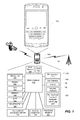
- FIG. 1 is a depiction of a mobile device on which the present technology may be implemented, the depiction including a schematic depiction of some components of the mobile device;
- FIG. 2 is a flowchart depicting a computer-implemented method of generating an atmospheric model in accordance with an implementation of the present technology
- FIG. 3 is a flowchart of one specific implementation of the method of generating an atmospheric model
- FIG. 4 depicts an options and settings page of a mobile device for use in configuring the manner in which the mobile device interacts with the atmospheric model
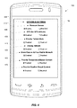
- FIG. 5 depicts a user interface of the mobile device displaying temperature, weather, pressure and altitude information obtained using the atmospheric model
- FIG. 6 depicts a map composed of adjoining areas for which a composite atmospheric model is generated in accordance with a further implementation of the technology.
- the present technology provides a novel way for a mobile device to generate an atmospheric model.
- one aspect of the present technology is a computer-implemented method of collecting pressure data and location data at a plurality of locations using one or more mobile devices each having a pressure sensor and a position-determining subsystem, the location data including altitude data, and generating an atmospheric model based on the pressure data and location data.
- the processor is configured to determine an Above Mean Sea Level (AMSL) altitude using a position-determining subsystem, determine a pressure altitude using the pressure sensor, calculate a difference between the pressure altitude and the AMSL altitude, and calculate a temperature at sea level based on the AMSL altitude and pressure altitude.
- AMSL Above Mean Sea Level
- the model may be used to estimate ambient air temperature or weather conditions.
- the model may be used to estimate ambient air temperature or weather conditions.
- a mobile device having a pressure sensor for collecting pressure data, a position-determining subsystem for generating location data including altitude data, and a processor operatively coupled to a memory to generate an atmospheric model based on the pressure data and the location data.
- the processor is configured to determine an Above Mean Sea Level (AMSL) altitude using a position-determining subsystem, determine a pressure altitude using the pressure sensor, calculate a difference between the pressure altitude and the AMSL altitude, and calculate a temperature at sea level based on the AMSL altitude and pressure altitude.
- AMSL Above Mean Sea Level
- the model may be used to estimate ambient air temperature or weather conditions.
- the present technology provides a mobile device, computer-readable medium and computer-implemented method for generating an atmospheric model using pressure and location data (that includes altitude data) collected using sensors on the device.
- the mobile device 100 includes a user interface 140 for interacting with the device and its applications.
- the user interface 140 may include one or more input/output devices, such as a display screen 150 (e.g. an LCD or LED screen or touch-sensitive display screen), and a keyboard or keypad 155.
- the user interface may also include an optical jog pad 160 and/or a thumbwheel, trackball, track pad or equivalent.
- the mobile device 100 includes a transceiver 170 for communicating with other devices.
- the transceiver 170 may be a radiofrequency (RF) transceiver for wirelessly communicating with one or more base stations over a cellular wireless network using cellular communication protocols and standards for both voice calls and packet data transfer such as GSM, CDMA, GPRS, EDGE, UMTS, LTE, etc.
- RF radiofrequency
- the mobile device 100 may include a Subscriber Identity Module (SIM) card 112 for GSM-type devices or a Re-Usable Identification Module (RUIM) card for CDMA-type devices.
- SIM Subscriber Identity Module
- RUIM Re-Usable Identification Module
- the RF transceiver 170 may include separate voice and data channels.
- the mobile device 100 may also include one or more ports for wired connections, e.g. USB, HDMI, FireWire (IEEE 1394), etc.
- ports for wired connections e.g. USB, HDMI, FireWire (IEEE 1394), etc.
- the mobile device 100 includes a speech-recognition subsystem that has a microphone 180 for transforming voice input in the form of sound waves into an electrical signal. The electrical signal is then processed by a speech-recognition module (digital signal processor) to determine keywords or phrases from the voice input.
- a speech-recognition module digital signal processor
- the mobile device 100 may include a speaker 182 and/or an earphone jack.
- the mobile device 100 may also include a position-determining subsystem such as a Global Positioning System (GPS) receiver 190 (e.g. in the form of a chip or chipset) for receiving GPS radio signals transmitted from one or more orbiting GPS satellites.
- GPS Global Positioning System
- Any other Global Navigation Satellite System (GNSS) such as GLONASS or Galileo, may be used for satellite-based positioning.
- GNSS Global Navigation Satellite System
- Other position-determining subsystems or techniques may be used, including radiolocation techniques, signal trace techniques, Wi-FiTM positioning system (WPS), etc. Any combination of these subsystems or techniques may also be used to provide a position fix (current location data) for the device.
- the position-determining subsystem may provide an altitude reading in addition to latitude and longitude coordinates.
- GNSS receivers such as a GPS receiver can compute a GPS altitude from signals from four orbiting satellites.
- the mobile device may include other sensors like a digital compass 196 and/or a tilt sensor or accelerometer 198.
- a wireless communications device is one example of a mobile device 100 on which the present technology may be implemented.
- Other mobile devices 100 may include smart phones, cell phones, PDAs, tablets, laptops, palmtops, or any other such devices.
- the mobile device 100 also includes a pressure sensor 200.
- the pressure sensor may be a micro-sensor or micro-electromechanical system (MEMS) embedded inside the mobile device.
- MEMS micro-electromechanical system
- the pressure sensor may be a piezo-resistive pressure sensor with an IC interface such as, for example, the LPS331AP MEMS pressure sensor manufactured and sold by STMicroelectronics NV. This sensor has an absolute pressure range of 260 to 1260 mbar and a resolution of 0.020 mbar RMS.
- the MEMS pressure sensor may be a BMP180 from Bosch Sensortec GmbH. Any other equivalent pressure sensor may be used.
- an external pressure sensor may be connected to the mobile device via a wired or wireless connection.
- the pressure sensor 200 provides pressure signals or pressure data to the processor 110 and memory 120, 130 of the mobile device 100, for example, via the IC interface.
- AMSL Above Mean Sea Level
- GPS Altitude is the altitude above or below the WGS84 ellipsoid, a model of the Earth used by GPS. Similar models are used in most GNSS systems. As pressure changes with gravity, GPS altitudes must be converted to AMSL altitudes before applying atmospheric equations.
- ISOlUSlICAO Standard Atmosphere is the standard atmospheric model assuming no weather, and the following conditions at 0 AMSL: 15C, 101325Pa, 1.98C/1000ft lapse rate.
- Pressure Altitude is the altitude calculated from pressure assuming ICAO standard atmosphere. No corrections are made for weather or temperature.
- Estimated AMSL Altitude is the altitude calculated from pressure correcting for temperature and local weather (high/low pressure regions). This value should equal AMSL Altitude.
- AMSL Altitude that is, a constant altitude for a fixed point that corresponds to a reference point such as sea level.
- the absolute pressure sensor provides a pressure reading from which Pressure Altitude is easily calculated.
- Pressure Altitude may have up to 1000ft of difference from AMSL Altitude, depending on the current weather, making this value behave differently than expected by the user.
- the Estimated AMSL Altitude can be calculated from the pressure for the current location - this is equal to the desired AMSL Altitude.
- AMSL Altitude and location from GPS (or other position-determining sources such as cellular triangulation, Wi-Fi positioning, NFC, or manual input.) depending on the accuracy of the specific source.
- GPS position-determining sources
- the altitude would be converted from GPS Altitude to AMSL Altitude.
- the mobile device 100 generates the atmospheric model by determining an Above Mean Sea Level (AMSL) altitude using a position-determining subsystem (e.g. GPS receiver 190) and determining a pressure altitude using the pressure sensor 200, calculating a difference or delta between the pressure altitude and the AMSL altitude, and then calculating a temperature at sea level based on the AMSL altitude and the pressure altitude, as will be elaborated below.
- AMSL Above Mean Sea Level
- the processor of the mobile device is configured to determine the AMSL altitude by obtaining a GPS altitude reading from the GPS receiver 190 in the mobile device.
- the processor is configured to then convert the GPS altitude to the AMSL altitude.
- Another aspect of the present technology is a novel method of generating an atmospheric model from multiple measurements obtained by one or more pressure-sensing and location-sensing mobile devices.
- the method utilizes at least one mobile device having a pressure sensor 200 for providing pressure data and a positioning system 190 for providing respective position data.
- these position-specific pressure measurements may be made using a single mobile device (which moves around to various positions to collect the pressure readings) or from a plurality of mobile devices in an ad-hoc network.
- the method entails a step 300 of collecting pressure data and location data at a plurality of locations using a mobile device 100 having a pressure sensor and a position-determining subsystem 190 capable of providing altitude data in addition to latitude and longitude data. Position data thus defines the location of the mobile device in three dimensions.
- the method further entails a step 310 of generating an atmospheric model based on the pressure data and location data. Subsequently, the atmospheric model may be used to determine an ambient air temperature (step 320) and to display this temperature on the device (step 330). Additionally or alternatively, the atmospheric model may be used to determine weather conditions (step 340) and to display the weather conditions on the device (step 350).
- the AMSL altitude may be determined at substep 361 using a position-determining subsystem, e.g. a GPS receiver capable of providing GPS altitude.
- the GPS position fix may be aided or assisted using Assisted GPS or Aided GPS.
- the pressure readings obtained using the pressure sensor 200 provide the Pressure Altitude at substep 362.
- step 366 calculate or estimate the difference between Pressure Altitude and AMSL Altitude for short periods (assuming the mean location). This difference corresponds to the weather effect and the temperature effect combined, and provides an altimeter setting for that time, location, and altitude.
- the weather effect is a constant offset, independent of the altitude.
- the temperature effect is a scale factor on altitude proportional to temperature.
- step 372 a model for pressure: AMSL Altitude and temperature at altitude (1.98C/1000ft) lapse rate, i.e. 6.5C per km, which is constant up to an altitude of 11 km. In another embodiment, a different lapse rate may be used.
- the pressure and location readings that contribute to the generation of the atmospheric model may derive from a single mobile device or from a group or plurality of mobile devices that together constitute an ad hoc network of mobile devices. Computations for the generation of the model may be performed on a server or on one or more of the mobile devices or any combination thereof.
- This mobile device may then use this atmospheric model for:
- pressure altimeters e.g. altimeters that use the onboard pressure sensor 200 on the mobile device 100
- Alerts, or notifications may be delivered to the mobile device to warn the user of icy road conditions, fog, bad weather, etc.
- Reminders (alerts) to close the windows in your car or your house may be delivered, to bring in your pet, or to water the lawn. Any of these actions, recommendations, alerts or notifications may be prompted by temperature, pressure or weather data determined locally based on the generated atmospheric model.
- touching or clicking on a weather icon may, in one embodiment, cause a detailed weather forecast for the location to be displayed.
- the device may interpolate the data to estimate the weather conditions, temperature or pressure at an intermediate location between two nearby locations for which data has been collected.
- the map data may be downloaded from a map server. This map data may be generated from vector data or bitmaps.
- FIG. 4 depicts an example of an options and settings interface 400 of a mobile device that enables the user of the mobile device to configure various options, settings, preferences and features.
- the options and settings interface is a page 400 displayable on the mobile device in response to a command or user input.
- the options and settings page 400 includes a pressure sensor setting 410, a GPS setting 420, a temperature display setting 430, an altitude display setting 440, and a data-sharing setting 450.
- the options and settings page 400 may include controls or settings 450, 460 to enable or disable the provision of temperature-based content and/or weather-based content.
- FIG. 5 depicts an example of a user interface of a handheld mobile device 100 that displays on its touch-sensitive display screen 150 various information and content that is created, derived from or based upon the atmospheric model.
- the mobile device 100 may contain one or more of a temperature display 500, a weather condition display 502, a pressure display 504 and an altitude display 506. These may be displayed in any other manner and may be user-configurable in their layout, presentation, onscreen location, system of units, font, size, etc.
- this temperature, pressure, weather and altitude information, data or readings may be presented in an upper information bar that contains the date and time in a date and time bar 508, for example.
- FIG. 5 depicts an example of a user interface of a handheld mobile device 100 that displays on its touch-sensitive display screen 150 various information and content that is created, derived from or based upon the atmospheric model.
- the mobile device 100 may contain one or more of a temperature display 500, a weather condition display 502, a pressure display 504 and an altitude display 506. These
- the mobile device 100 may display temperature-based content, alerts or notifications 510 and/or weather-based content, alerts or notifications 512.
- the mobile device may display a status indicator 514 indicating that the device is currently contributing its pressure and location data to ad hoc network of mobile devices for the purposes of generating the atmospheric model.
- a user-configurable setting in one embodiment, enables the user to disable location data sharing if privacy is a concern.
- the atmospheric model in one implementation is continually, periodically, intermittently or dynamically updated as new pressure and location data is collected and becomes available for use in regenerating the model.
- the new data may be used to incrementally replace data that becomes old or stale over time.
- the model may thus use a moving time window to refresh the model by continually, periodically or intermittently importing new data and flushing out the oldest data.
- the time window may be user-configurable.
- FIG. 6 depicts an example map that further illustrates the concept of creating a composite atmospheric model from a plurality of localized atmospheric models that have been each generated for respective adjoining geographical areas of a map.
- there are nine adjoining map areas namely Areas A-I, which are referenced by numerals 600-616.
- Areas A-I which are referenced by numerals 600-616.
- the map shown in FIG. 6 is just one example and that the number of map areas may be varied.
- Each area is shown as rectangular in the example of FIG. 6 but other polygonal shapes may be used.
- a localized atmospheric model for that area may be generated.
- Areas B, D, E and H (602, 606, 608, 614) have mobile devices 100 collecting pressure and location data. Therefore, in this example, atmospheric models are generated only for Areas B, D, E, and H. No models are generated for Areas A, C, F, G, and I.
- a composite model i.e. mosaic of models
- the composite model may, in other embodiments, be created from a patchwork or mosaic of disparate (non-contiguous or non-adjoining) areas.
- the map areas 600-616 are sized to correspond with Maplets or map tiles of a digital map database. For example, some digital maps are divided into Maplets or map tiles for different zoom levels. Each area may be selected to correspond to one of these map tiles (assuming there is a map tile size at one zoom level that is approximately the desired size for model generation). In other embodiments, the localized area for model generation is unrelated to the map tiles or tile size of any map database.
- any of the methods disclosed herein may be implemented in hardware, software, firmware or any combination thereof.
- the method steps, acts or operations may be programmed or coded as computer-readable instructions and recorded electronically, magnetically or optically on a fixed or non-transitory computer-readable medium, computer-readable memory, machine-readable memory or computer program product.
- the computer-readable memory or computer-readable medium comprises instructions in code which when loaded into a memory and executed on a processor of a computing device cause the computing device to perform one or more of the foregoing method(s).
- a computer-readable medium can be any means that contain, store, communicate, propagate or transport the program for use by or in connection with the instruction execution system, apparatus or device.
- the computer-readable medium may be electronic, magnetic, optical, electromagnetic, infrared or any semiconductor system or device.
- computer executable code to perform the methods disclosed herein may be tangibly recorded on a computer-readable medium including, but not limited to, a floppy-disk, a CD-ROM, a DVD, RAM, ROM, EPROM, Flash Memory or any suitable memory card, etc.
- the method may also be implemented in hardware.
- a hardware implementation might employ discrete logic circuits having logic gates for implementing logic functions on data signals, an application-specific integrated circuit (ASIC) having appropriate combinational logic gates, a programmable gate array (PGA), a field programmable gate array (FPGA), etc.
Landscapes
- Environmental & Geological Engineering (AREA)
- Engineering & Computer Science (AREA)
- Life Sciences & Earth Sciences (AREA)
- Atmospheric Sciences (AREA)
- Biodiversity & Conservation Biology (AREA)
- Ecology (AREA)
- Environmental Sciences (AREA)
- Telephone Function (AREA)
Abstract
Description
- The present technology relates generally to mobile devices and, in particular, to techniques for determining atmospheric or weather conditions using mobile devices.
- Mobile devices having wireless data connectivity may obtain real-time weather data over the air from web servers that receive and publish such data from weather services that operate fixed ground-based weather stations. It is also known to receive weather alerts wirelessly. However, one of the recurring problems with this conventional approach is that localized weather conditions where the mobile devices are currently situated may differ rather substantially from the weather conditions measured at the distant ground-based weather stations. A solution to this problem would thus be highly desirable.
- Further features and advantages of the present technology will become apparent from the following detailed description, taken in combination with the appended drawings, in which:
-
FIG. 1 is a depiction of a mobile device on which the present technology may be implemented, the depiction including a schematic depiction of some components of the mobile device; -
FIG. 2 is a flowchart depicting a computer-implemented method of generating an atmospheric model in accordance with an implementation of the present technology; -
FIG. 3 is a flowchart of one specific implementation of the method of generating an atmospheric model; -
FIG. 4 depicts an options and settings page of a mobile device for use in configuring the manner in which the mobile device interacts with the atmospheric model; -
FIG. 5 depicts a user interface of the mobile device displaying temperature, weather, pressure and altitude information obtained using the atmospheric model; and -
FIG. 6 depicts a map composed of adjoining areas for which a composite atmospheric model is generated in accordance with a further implementation of the technology. - It will be noted that throughout the appended drawings, like features are identified by like reference numerals.
- The present technology provides a novel way for a mobile device to generate an atmospheric model.
- Accordingly, one aspect of the present technology is a computer-implemented method of collecting pressure data and location data at a plurality of locations using one or more mobile devices each having a pressure sensor and a position-determining subsystem, the location data including altitude data, and generating an atmospheric model based on the pressure data and location data. In one implementation, the processor is configured to determine an Above Mean Sea Level (AMSL) altitude using a position-determining subsystem, determine a pressure altitude using the pressure sensor, calculate a difference between the pressure altitude and the AMSL altitude, and calculate a temperature at sea level based on the AMSL altitude and pressure altitude. In one implementation, the processor performs a linear regression on an equation AMSL altitude = offset + ScaleFactor * PressureAltitude to solve for the offset and the ScaleFactor, and then estimates the temperature at sea level as 1-ScaleFactor = (T-15)/3. The model may be used to estimate ambient air temperature or weather conditions.
- Another aspect of the present technology is a computer-readable medium comprising instructions in code which when loaded into a memory and executed by a processor of a mobile device cause the mobile device to collect pressure data and location data at a plurality of locations using a mobile device having a pressure sensor and a position-determining subsystem, the location data including altitude data, and then generate an atmospheric model based on the pressure data and location data. In one implementation, the processor is configured to determine an Above Mean Sea Level (AMSL) altitude using a position-determining subsystem, determine a pressure altitude using the pressure sensor, calculate a difference between the pressure altitude and the AMSL altitude, and calculate a temperature at sea level based on the AMSL altitude and pressure altitude. In one implementation, the processor performs a linear regression on an equation AMSL altitude = offset + ScaleFactor * PressureAltitude to solve for the offset and the ScaleFactor, and then estimates the temperature at sea level as 1-ScaleFactor = (T-15)/3. The model may be used to estimate ambient air temperature or weather conditions.
- Another aspect of the present technology is a mobile device having a pressure sensor for collecting pressure data, a position-determining subsystem for generating location data including altitude data, and a processor operatively coupled to a memory to generate an atmospheric model based on the pressure data and the location data. In one implementation, the processor is configured to determine an Above Mean Sea Level (AMSL) altitude using a position-determining subsystem, determine a pressure altitude using the pressure sensor, calculate a difference between the pressure altitude and the AMSL altitude, and calculate a temperature at sea level based on the AMSL altitude and pressure altitude. In one implementation, the processor performs a linear regression on an equation AMSL altitude = offset + ScaleFactor * PressureAltitude to solve for the offset and the ScaleFactor, and then estimates the temperature at sea level as 1-ScaleFactor = (T-15)/3. The model may be used to estimate ambient air temperature or weather conditions.
- The details and particulars of these aspects of the technology will now be described below, by way of example, with reference to the drawings.
- By way of overview, the present technology provides a mobile device, computer-readable medium and computer-implemented method for generating an atmospheric model using pressure and location data (that includes altitude data) collected using sensors on the device.
- DEVICE
-
FIG. 1 is a depiction of a wireless communications device as one example of a mobile device that may be used to implement this novel technology. This mobile device, which is generally designated byreference numeral 100, includes aprocessor 110 andmemory flash memory 120 and/or random access memory (RAM) 130. Other types or forms of memory may be used. - As depicted by way of example in
FIG. 1 , themobile device 100 includes auser interface 140 for interacting with the device and its applications. Theuser interface 140 may include one or more input/output devices, such as a display screen 150 (e.g. an LCD or LED screen or touch-sensitive display screen), and a keyboard orkeypad 155. The user interface may also include anoptical jog pad 160 and/or a thumbwheel, trackball, track pad or equivalent. - As depicted by way of example in
FIG. 1 , themobile device 100 includes atransceiver 170 for communicating with other devices. Thetransceiver 170 may be a radiofrequency (RF) transceiver for wirelessly communicating with one or more base stations over a cellular wireless network using cellular communication protocols and standards for both voice calls and packet data transfer such as GSM, CDMA, GPRS, EDGE, UMTS, LTE, etc. - The
mobile device 100 may include a Subscriber Identity Module (SIM)card 112 for GSM-type devices or a Re-Usable Identification Module (RUIM) card for CDMA-type devices. TheRF transceiver 170 may include separate voice and data channels. - The
mobile device 100 may also include one or more ports for wired connections, e.g. USB, HDMI, FireWire (IEEE 1394), etc. - The
mobile device 100 includes a speech-recognition subsystem that has amicrophone 180 for transforming voice input in the form of sound waves into an electrical signal. The electrical signal is then processed by a speech-recognition module (digital signal processor) to determine keywords or phrases from the voice input. Optionally, themobile device 100 may include aspeaker 182 and/or an earphone jack. - Optionally, the
mobile device 100 may also include a position-determining subsystem such as a Global Positioning System (GPS) receiver 190 (e.g. in the form of a chip or chipset) for receiving GPS radio signals transmitted from one or more orbiting GPS satellites. Any other Global Navigation Satellite System (GNSS), such as GLONASS or Galileo, may be used for satellite-based positioning. Other position-determining subsystems or techniques may be used, including radiolocation techniques, signal trace techniques, Wi-Fi™ positioning system (WPS), etc. Any combination of these subsystems or techniques may also be used to provide a position fix (current location data) for the device. The position-determining subsystem may provide an altitude reading in addition to latitude and longitude coordinates. For example, GNSS receivers such as a GPS receiver can compute a GPS altitude from signals from four orbiting satellites. - Optionally, the
mobile device 100 may include a Wi-Fi™ transceiver 192, a Bluetooth®transceiver 194, and/or a near-field communications (NFC) chip. Thecomputing device 100 may also optionally include a transceiver for WiMax™ (IEEE 802.16), a transceiver for ZigBee® (IEEE 802.15.4-2003 or other wireless personal area networks), an infrared transceiver or an ultra-wideband transceiver. - Optionally, the mobile device may include other sensors like a
digital compass 196 and/or a tilt sensor oraccelerometer 198. - As noted above, a wireless communications device is one example of a
mobile device 100 on which the present technology may be implemented. Othermobile devices 100 may include smart phones, cell phones, PDAs, tablets, laptops, palmtops, or any other such devices. - The
mobile device 100 also includes apressure sensor 200. The pressure sensor may be a micro-sensor or micro-electromechanical system (MEMS) embedded inside the mobile device. For example, the pressure sensor may be a piezo-resistive pressure sensor with an IC interface such as, for example, the LPS331AP MEMS pressure sensor manufactured and sold by STMicroelectronics NV. This sensor has an absolute pressure range of 260 to 1260 mbar and a resolution of 0.020 mbar RMS. Alternatively, the MEMS pressure sensor may be a BMP180 from Bosch Sensortec GmbH. Any other equivalent pressure sensor may be used. In a variant, an external pressure sensor may be connected to the mobile device via a wired or wireless connection. Thepressure sensor 200 provides pressure signals or pressure data to theprocessor 110 andmemory mobile device 100, for example, via the IC interface. - Pressure data and location data (including altitude data) may be collected using a single mobile device that moves to different locations over time or by a plurality of mobile devices acting as an ad hoc network. Irrespective of whether the data is collected by one or more devices, the pressure and location data is collected at a plurality of different locations using the one or more mobile devices each being equipped with a pressure sensor and a position-determining subsystem able to provide altitude data as part of the positioning. The mobile device(s) and/or a server, server cluster or cloud operating in connection with the device(s) generates an atmospheric model based on the pressure data and location data. The altitude data may be AMSL or GPS Altitude. These concepts, and some related altitude concepts, are now reviewed to facilitate understanding of this novel technology.
- Above Mean Sea Level (AMSL) is the absolute height above the point where the sea level would be if a trench was dug from that point to the sea and sea water was permitted to pass freely between the sea and the trench. This is a gravity-based definition such as the one defined in the Earth Gravitational Model (EGM96).
- GPS Altitude is the altitude above or below the WGS84 ellipsoid, a model of the Earth used by GPS. Similar models are used in most GNSS systems. As pressure changes with gravity, GPS altitudes must be converted to AMSL altitudes before applying atmospheric equations.
- ISOlUSlICAO Standard Atmosphere is the standard atmospheric model assuming no weather, and the following conditions at 0 AMSL: 15C, 101325Pa, 1.98C/1000ft lapse rate.
- Pressure Altitude is the altitude calculated from pressure assuming ICAO standard atmosphere. No corrections are made for weather or temperature.
- Estimated AMSL Altitude is the altitude calculated from pressure correcting for temperature and local weather (high/low pressure regions). This value should equal AMSL Altitude.
- Users expect to see AMSL Altitude, that is, a constant altitude for a fixed point that corresponds to a reference point such as sea level. The absolute pressure sensor provides a pressure reading from which Pressure Altitude is easily calculated. Unfortunately, Pressure Altitude may have up to 1000ft of difference from AMSL Altitude, depending on the current weather, making this value behave differently than expected by the user.
- Given a weather model, the Estimated AMSL Altitude can be calculated from the pressure for the current location - this is equal to the desired AMSL Altitude.
- It is also possible to obtain an AMSL Altitude and location from GPS (or other position-determining sources such as cellular triangulation, Wi-Fi positioning, NFC, or manual input.) depending on the accuracy of the specific source. In the case of GPS, the altitude would be converted from GPS Altitude to AMSL Altitude.
- In general terms, the
mobile device 100 generates the atmospheric model by determining an Above Mean Sea Level (AMSL) altitude using a position-determining subsystem (e.g. GPS receiver 190) and determining a pressure altitude using thepressure sensor 200, calculating a difference or delta between the pressure altitude and the AMSL altitude, and then calculating a temperature at sea level based on the AMSL altitude and the pressure altitude, as will be elaborated below. - The calculation of the temperature at sea level may be accomplished in one implementation by performing a linear regression on an equation AMSL altitude = offset + ScaleFactor * PressureAltitude to solve for the offset and the ScaleFactor and by then estimating the temperature at sea level as 1-ScaleFactor = (T-15)/3. Thereafter, the atmospheric model for pressure is generated based on the AMSL altitude and temperature at altitude using a lapse rate of 1.98C/1000ft (6.5C per km).
- In one embodiment, the processor of the mobile device is configured to determine the AMSL altitude by obtaining a GPS altitude reading from the
GPS receiver 190 in the mobile device. The processor is configured to then convert the GPS altitude to the AMSL altitude. - The processor may be further configured to determine ambient air temperature using the atmospheric model and to cause a display to display the temperature on the mobile device. Additionally or alternatively, the processor may be configured to determine weather conditions using the atmospheric model and to cause a display to display the weather conditions on the mobile device.
- METHOD
- Another aspect of the present technology is a novel method of generating an atmospheric model from multiple measurements obtained by one or more pressure-sensing and location-sensing mobile devices. The method utilizes at least one mobile device having a
pressure sensor 200 for providing pressure data and apositioning system 190 for providing respective position data. As previously noted, these position-specific pressure measurements may be made using a single mobile device (which moves around to various positions to collect the pressure readings) or from a plurality of mobile devices in an ad-hoc network. In general, as depicted in the flowchart ofFIG. 2 , the method entails a step 300 of collecting pressure data and location data at a plurality of locations using amobile device 100 having a pressure sensor and a position-determiningsubsystem 190 capable of providing altitude data in addition to latitude and longitude data. Position data thus defines the location of the mobile device in three dimensions. The method further entails astep 310 of generating an atmospheric model based on the pressure data and location data. Subsequently, the atmospheric model may be used to determine an ambient air temperature (step 320) and to display this temperature on the device (step 330). Additionally or alternatively, the atmospheric model may be used to determine weather conditions (step 340) and to display the weather conditions on the device (step 350). - In one implementation, the method of generating the atmospheric model proceeds as depicted in the flowchart of
FIG. 3 : - 1. Collect a set of measurements: <device, time, location, pressure, AMSL Altitude>, as shown in
step 360. The AMSL altitude may be determined at substep 361 using a position-determining subsystem, e.g. a GPS receiver capable of providing GPS altitude. The GPS position fix may be aided or assisted using Assisted GPS or Aided GPS. The pressure readings obtained using thepressure sensor 200 provide the Pressure Altitude atsubstep 362. - 2. Pre-filter AMSL Altitude measurements per device based on accuracy, time consistency with pressure changes (i.e. reject inconsistent readings), as shown in
step 364. - 3. For each device, as shown in step 366, calculate or estimate the difference between Pressure Altitude and AMSL Altitude for short periods (assuming the mean location). This difference corresponds to the weather effect and the temperature effect combined, and provides an altimeter setting for that time, location, and altitude.
- a) The weather effect is a constant offset, independent of the altitude.
- b) The temperature effect is a scale factor on altitude proportional to temperature.
- 4. As weather effects (low pressure/high pressure regions) usually extend over a large area (which can be any arbitrary area, e.g. ∼100km2 or a 100 km radius or any other area which may be user-configurable), and are generally assumed to be slow to change, choose a set of measurements over the approximate 100km2 area and over about 0.5 to 1 hour (i.e. 30-60 minutes) or any other suitable time period, which is also user-configurable. Then perform a linear regression (step 368) on the equation AMSL Altitude = offset + ScaleFactor * PressureAltitude and solve for offset and ScaleFactor.
- 5. Calculate or approximate the temperature at sea level as 1-ScaleFactor = (T-15)/3 at
step 370. In another embodiment, a different ScaleFactor equation may be substituted. - 6. This produces at step 372 a model for pressure: AMSL Altitude and temperature at altitude (1.98C/1000ft) lapse rate, i.e. 6.5C per km, which is constant up to an altitude of 11 km. In another embodiment, a different lapse rate may be used.
- The pressure and location readings that contribute to the generation of the atmospheric model may derive from a single mobile device or from a group or plurality of mobile devices that together constitute an ad hoc network of mobile devices. Computations for the generation of the model may be performed on a server or on one or more of the mobile devices or any combination thereof.
- This mobile device may then use this atmospheric model for:
- 1) providing accurate altimeter settings for pressure altimeters (e.g. altimeters that use the
onboard pressure sensor 200 on the mobile device 100) for improved altitude determination or for providing alerts, notifications, content, etc. based on these conditions; - 2) estimating an outside or ambient air temperature (which is conventionally very difficult to measure using a temperature sensor in the device due to the significant heat that the device electronics generates), or providing alerts, notifications, content, etc. based on temperature; or
- 3) determining weather conditions or statistics (e.g. observing pressure trends, predicting weather changes, etc.), or providing alerts, notifications, content, etc. based on these conditions;
- In each of these three uses, the atmospheric model provides much more accurate localized pressure and temperature information than what would be available by pulling weather data from web-based weather services that are relying on distant fixed ground-based weather stations. As mentioned above, the atmospheric model enables the device to measure localized temperature and pressure and to provide a variety of functions, settings and content based on temperature and/or pressure and/or weather. For example, the device may deliver content or advertising when the temperature reaches a certain threshold or when certain weather conditions are prevailing. For example, location-based advertising (LBA) may be delivered for cold drinks if the temperature exceeds a certain threshold. As another example, LBA for a sale on umbrellas at a local department store may be delivered if the weather conditions are suggesting rain. Content, alerts, or notifications may be delivered to the mobile device to warn the user of icy road conditions, fog, bad weather, etc. Reminders (alerts) to close the windows in your car or your house may be delivered, to bring in your pet, or to water the lawn. Any of these actions, recommendations, alerts or notifications may be prompted by temperature, pressure or weather data determined locally based on the generated atmospheric model.
- In one implementation, the weather data, or just the temperature data and/or pressure data, may be displayed on a map on the
mobile device 100. For example, the weather may be displayed graphically with standard or user-configurable icons representing sunshine, clouds, rain, snow, fog, etc. Additionally or alternatively, the map may display numerical values of temperature (in Celsius or Fahrenheit) and/or pressure (in any suitable system of pressure units) at various locations on the map, e.g. at cities or other geographical entities, landmarks or points of interests, etc. The weather icons and/or numerical values of temperature and/or pressure may be interactive interface elements that respond to user input to provide further detail about the local weather conditions, temperature, pressure, etc.. For example, touching or clicking on a weather icon may, in one embodiment, cause a detailed weather forecast for the location to be displayed. In another implementation, it may be possible to view all of the mobile devices that are presently collecting and sharing data. In another implementation, the device may interpolate the data to estimate the weather conditions, temperature or pressure at an intermediate location between two nearby locations for which data has been collected. The map data may be downloaded from a map server. This map data may be generated from vector data or bitmaps. -
FIG. 4 depicts an example of an options and settings interface 400 of a mobile device that enables the user of the mobile device to configure various options, settings, preferences and features. As depicted by way of example, the options and settings interface is apage 400 displayable on the mobile device in response to a command or user input. As illustrated by way of example inFIG. 4 , the options andsettings page 400 includes a pressure sensor setting 410, a GPS setting 420, a temperature display setting 430, an altitude display setting 440, and a data-sharingsetting 450. In addition, as further depicted by way of example inFIG. 4 , the options andsettings page 400 may include controls orsettings -
FIG. 5 depicts an example of a user interface of a handheldmobile device 100 that displays on its touch-sensitive display screen 150 various information and content that is created, derived from or based upon the atmospheric model. For example, themobile device 100 may contain one or more of atemperature display 500, aweather condition display 502, apressure display 504 and analtitude display 506. These may be displayed in any other manner and may be user-configurable in their layout, presentation, onscreen location, system of units, font, size, etc. In the illustrated embodiment, this temperature, pressure, weather and altitude information, data or readings may be presented in an upper information bar that contains the date and time in a date andtime bar 508, for example. In addition, as further depicted by way of example inFIG. 5 , themobile device 100 may display temperature-based content, alerts ornotifications 510 and/or weather-based content, alerts ornotifications 512. In addition, as further depicted by way of example inFIG. 5 , the mobile device may display astatus indicator 514 indicating that the device is currently contributing its pressure and location data to ad hoc network of mobile devices for the purposes of generating the atmospheric model. A user-configurable setting, in one embodiment, enables the user to disable location data sharing if privacy is a concern. - It is also to be understood that the atmospheric model in one implementation is continually, periodically, intermittently or dynamically updated as new pressure and location data is collected and becomes available for use in regenerating the model. The new data may be used to incrementally replace data that becomes old or stale over time. The model may thus use a moving time window to refresh the model by continually, periodically or intermittently importing new data and flushing out the oldest data. The time window may be user-configurable.
- In addition, the mobile device or plurality of mobile devices in the ad hoc network may share the atmospheric model with a server, server cluster, user group or other local, connected devices.
- In the foregoing embodiments, the atmospheric model is generated for a localized area, e.g. 100 square km, by using pressure readings from mobile devices within that localized area. In another embodiment, atmospheric models for adjoining areas may be combined to form larger scale models or composite models of multiple adjoining areas. In other words, a first atmospheric model for a first area may be combined, joined or aggregated with a second atmospheric model for a second area. This concept may be extrapolated so that a plurality of atmospheric models for a plurality of contiguous or adjoining areas are combined or aggregated to produce a large-scale composite atmospheric model covering a much larger area. In theory, this technique may be used to generate a model for all habited areas of the Earth where mobile users are situated.
-
FIG. 6 depicts an example map that further illustrates the concept of creating a composite atmospheric model from a plurality of localized atmospheric models that have been each generated for respective adjoining geographical areas of a map. In the example map ofFIG. 6 , there are nine adjoining map areas, namely Areas A-I, which are referenced by numerals 600-616. It will be appreciated that the map shown inFIG. 6 is just one example and that the number of map areas may be varied. Each area is shown as rectangular in the example ofFIG. 6 but other polygonal shapes may be used. For each area where mobile devices are present and are collecting pressure and location data, a localized atmospheric model for that area may be generated. In this example, only Areas B, D, E and H (602, 606, 608, 614) havemobile devices 100 collecting pressure and location data. Therefore, in this example, atmospheric models are generated only for Areas B, D, E, and H. No models are generated for Areas A, C, F, G, and I. A composite model (i.e. mosaic of models) may thus be created or formed by joining or merging the models for Areas B, D, E and H. Although in this example, the areas (B, D, E and H) are contiguous and adjoining, the composite model may, in other embodiments, be created from a patchwork or mosaic of disparate (non-contiguous or non-adjoining) areas. - In one implementation, the map areas 600-616 are sized to correspond with Maplets or map tiles of a digital map database. For example, some digital maps are divided into Maplets or map tiles for different zoom levels. Each area may be selected to correspond to one of these map tiles (assuming there is a map tile size at one zoom level that is approximately the desired size for model generation). In other embodiments, the localized area for model generation is unrelated to the map tiles or tile size of any map database.
- Composite atmospheric models for various regions, cities, districts, counties, states, provinces, countries, etc. may be shared or pushed to a centralized server, server cluster, server farm, or to the cloud for access by other mobile devices, cloud-based applications or web services. This technology can thus provide a mobile and potentially global network of pressure-sensing mobile devices from which real-time pressure, temperature and weather information can be determined.
- COMPUTER-READABLE MEDIUM
- Any of the methods disclosed herein may be implemented in hardware, software, firmware or any combination thereof. Where implemented as software, the method steps, acts or operations may be programmed or coded as computer-readable instructions and recorded electronically, magnetically or optically on a fixed or non-transitory computer-readable medium, computer-readable memory, machine-readable memory or computer program product. In other words, the computer-readable memory or computer-readable medium comprises instructions in code which when loaded into a memory and executed on a processor of a computing device cause the computing device to perform one or more of the foregoing method(s).
- A computer-readable medium can be any means that contain, store, communicate, propagate or transport the program for use by or in connection with the instruction execution system, apparatus or device. The computer-readable medium may be electronic, magnetic, optical, electromagnetic, infrared or any semiconductor system or device. For example, computer executable code to perform the methods disclosed herein may be tangibly recorded on a computer-readable medium including, but not limited to, a floppy-disk, a CD-ROM, a DVD, RAM, ROM, EPROM, Flash Memory or any suitable memory card, etc. The method may also be implemented in hardware. A hardware implementation might employ discrete logic circuits having logic gates for implementing logic functions on data signals, an application-specific integrated circuit (ASIC) having appropriate combinational logic gates, a programmable gate array (PGA), a field programmable gate array (FPGA), etc.
- This invention has been described in terms of specific embodiments, implementations and configurations which are intended to be exemplary only. Persons of ordinary skill in the art will appreciate, having read this disclosure, that many obvious variations, modifications and refinements may be made without departing from the inventive concept(s) presented herein. The scope of the exclusive right sought by the Applicant(s) is therefore intended to be limited solely by the appended claims.
Claims (15)
- A computer-implemented method comprising:collecting pressure data and location data at a plurality of locations using one or more mobile devices each having a pressure sensor and a position-determining subsystem, the location data including altitude data; andgenerating an atmospheric model based on the pressure data and location data.
- The method as claimed in claim 1 wherein generating the atmospheric model comprises:determining an Above Mean Sea Level (AMSL) altitude using a position-determining subsystem;determining a pressure altitude using the pressure sensor;calculating a difference between the pressure altitude and the AMSL altitude; andcalculating a temperature at sea level based on the AMSL altitude and the pressure altitude.
- The method as claimed in claim 2 wherein determining the temperature at sea level comprises:performing a linear regression on an equation AMSL altitude = offset + ScaleFactor * PressureAltitude to solve for the offset and the ScaleFactor; andcalculating the temperature at sea level as 1-ScaleFactor = (T-15)/3.
- The method as claimed in claim 3 further comprising generating the atmospheric model for pressure based on the AMSL altitude and temperature at altitude using a lapse rate of 1.98C/1000ft (6.5C per km).
- The method as claimed in any one of claims 2 to 4 wherein collecting pressure data and location data comprises collecting pressure data and location data over a predetermined area for a predetermined period of time and then pre-filtering AMSL altitude measurements based on accuracy and time consistency with pressure changes.
- The method as claimed in any one of claims 2 to 5 wherein determining the AMSL altitude comprises obtaining a GPS altitude reading from a GPS receiver in the mobile device and converting the GPS altitude to the AMSL altitude.
- The method as claimed in any preceding claim further comprising determining an ambient air temperature using the atmospheric model and displaying the temperature on the mobile device.
- The method as claimed in any preceding claim further comprising determining weather conditions using the atmospheric model and displaying the weather conditions on the mobile device.
- The method as claimed in any preceding claim comprising collecting pressure data and location data using a plurality of mobile devices located at the plurality of locations.
- A computer-readable medium comprising instructions in code which when loaded into a memory and executed by a processor of a mobile device cause the mobile device to perform the method as claimed in any one of the preceding claims.
- A mobile device comprising:a pressure sensor for collecting pressure data;a position-determining subsystem for generating location data including altitude data; anda processor operatively coupled to a memory to generate an atmospheric model based on the pressure data and the location data.
- The mobile device as claimed in claim 11 wherein the processor is configured to:determine an Above Mean Sea Level (AMSL) altitude using a position-determining subsystem;determine a pressure altitude using the pressure sensor;calculate a difference between the pressure altitude and the AMSL altitude; andcalculate a temperature at sea level based on the AMSL altitude and the pressure altitude.
- The mobile device as claimed in claim 12 wherein the processor is configured to perform a linear regression on an equation AMSL altitude = offset + ScaleFactor * PressureAltitude to solve for the offset and the ScaleFactor and to calculate the temperature at sea level as 1-ScaleFactor = (T-15)/3.
- The mobile device as claimed in claim 13 wherein the processor is configured to determine the AMSL altitude by obtaining a GPS altitude reading from a GPS receiver in the mobile device and to convert the GPS altitude to the AMSL altitude.
- The mobile device as claimed in any one of claims 11 to 14 wherein the processor is configured to determine either (i) ambient air temperature using the atmospheric model and to cause a display to display the temperature on the mobile device or (ii) weather conditions using the atmospheric model and to cause a display to display the weather conditions on the mobile device.
Priority Applications (1)
| Application Number | Priority Date | Filing Date | Title |
|---|---|---|---|
| EP12188951.3A EP2722693B1 (en) | 2012-10-18 | 2012-10-18 | Generating an atmospheric model using one or more pressure-sensing mobile devices |
Applications Claiming Priority (1)
| Application Number | Priority Date | Filing Date | Title |
|---|---|---|---|
| EP12188951.3A EP2722693B1 (en) | 2012-10-18 | 2012-10-18 | Generating an atmospheric model using one or more pressure-sensing mobile devices |
Publications (2)
| Publication Number | Publication Date |
|---|---|
| EP2722693A1 true EP2722693A1 (en) | 2014-04-23 |
| EP2722693B1 EP2722693B1 (en) | 2019-04-03 |
Family
ID=47357896
Family Applications (1)
| Application Number | Title | Priority Date | Filing Date |
|---|---|---|---|
| EP12188951.3A Active EP2722693B1 (en) | 2012-10-18 | 2012-10-18 | Generating an atmospheric model using one or more pressure-sensing mobile devices |
Country Status (1)
| Country | Link |
|---|---|
| EP (1) | EP2722693B1 (en) |
Cited By (4)
| Publication number | Priority date | Publication date | Assignee | Title |
|---|---|---|---|---|
| CN105954821A (en) * | 2016-04-20 | 2016-09-21 | 中国水利水电科学研究院 | Typical rainfall event selection method for numerical atmospheric model |
| US20160360501A1 (en) * | 2014-12-18 | 2016-12-08 | Alibaba Group Holding Limited | Method and apparatus of positioning mobile terminal based on geomagnetism |
| US10242508B2 (en) * | 2017-01-10 | 2019-03-26 | Honeywell International Inc. | Aircraft maintenance systems and methods for ECS fouling predictions |
| US10534359B2 (en) | 2017-01-10 | 2020-01-14 | Honeywell International Inc. | Aircraft management systems and methods for ECS predictive maintenance |
Families Citing this family (1)
| Publication number | Priority date | Publication date | Assignee | Title |
|---|---|---|---|---|
| US10885587B1 (en) * | 2015-05-05 | 2021-01-05 | Allstate Insurance Company | Catastrophe resource system |
Citations (3)
| Publication number | Priority date | Publication date | Assignee | Title |
|---|---|---|---|---|
| DE20003823U1 (en) * | 2000-03-01 | 2000-08-24 | Hölbl, Werner, Wien | Weather warning device with GPS |
| DE202004019542U1 (en) * | 2003-12-19 | 2005-03-03 | Suunto Oy | Outdoor Computers |
| WO2008148649A1 (en) * | 2007-06-07 | 2008-12-11 | Qualcomm Incorporated | Weather prediction system |
-
2012
- 2012-10-18 EP EP12188951.3A patent/EP2722693B1/en active Active
Patent Citations (3)
| Publication number | Priority date | Publication date | Assignee | Title |
|---|---|---|---|---|
| DE20003823U1 (en) * | 2000-03-01 | 2000-08-24 | Hölbl, Werner, Wien | Weather warning device with GPS |
| DE202004019542U1 (en) * | 2003-12-19 | 2005-03-03 | Suunto Oy | Outdoor Computers |
| WO2008148649A1 (en) * | 2007-06-07 | 2008-12-11 | Qualcomm Incorporated | Weather prediction system |
Cited By (4)
| Publication number | Priority date | Publication date | Assignee | Title |
|---|---|---|---|---|
| US20160360501A1 (en) * | 2014-12-18 | 2016-12-08 | Alibaba Group Holding Limited | Method and apparatus of positioning mobile terminal based on geomagnetism |
| CN105954821A (en) * | 2016-04-20 | 2016-09-21 | 中国水利水电科学研究院 | Typical rainfall event selection method for numerical atmospheric model |
| US10242508B2 (en) * | 2017-01-10 | 2019-03-26 | Honeywell International Inc. | Aircraft maintenance systems and methods for ECS fouling predictions |
| US10534359B2 (en) | 2017-01-10 | 2020-01-14 | Honeywell International Inc. | Aircraft management systems and methods for ECS predictive maintenance |
Also Published As
| Publication number | Publication date |
|---|---|
| EP2722693B1 (en) | 2019-04-03 |
Similar Documents
| Publication | Publication Date | Title |
|---|---|---|
| US9535189B2 (en) | Generating an atmospheric model using one or more pressure-sensing mobile devices | |
| US20140114567A1 (en) | Generating an elevation model using mobile devices | |
| JP6587297B2 (en) | Method and system for displaying short-term forecasts along a route on a map | |
| EP2917689B1 (en) | Techniques for generating environment and reference data reports for particular environments on behalf of mobile devices | |
| US9980246B2 (en) | Systems and methods for using three-dimensional location information to improve location services | |
| US9983002B2 (en) | Enhancing geolocation using barometric data to determine floors at a location | |
| US9841284B2 (en) | Distributed barometer network to assist in indoor navigation | |
| EP3586081B1 (en) | Altitude map for indoor positioning services | |
| US20120316831A1 (en) | System and method for determining altitude | |
| EP2722693B1 (en) | Generating an atmospheric model using one or more pressure-sensing mobile devices | |
| US10993204B2 (en) | Systems and methods for determining if a receiver is inside or outside a building or area | |
| CN103636142A (en) | Calibration method of air pressure for mobile device, calibration device and mobile device | |
| US12345546B2 (en) | Device based barometric pressure sensor calibration | |
| JP5094589B2 (en) | Current position estimation apparatus, method and system | |
| US10542386B2 (en) | Horizontal position estimate based on interfloor connectors | |
| EP2722683A1 (en) | Generating An Elevation Model Using Mobile Devices | |
| CN119687864A (en) | Altitude calculating method, altitude calculating device, electronic equipment and computer storage medium | |
| TW201508307A (en) | Portable electronic device and method for operating user interface |
Legal Events
| Date | Code | Title | Description |
|---|---|---|---|
| PUAI | Public reference made under article 153(3) epc to a published international application that has entered the european phase |
Free format text: ORIGINAL CODE: 0009012 |
|
| 17P | Request for examination filed |
Effective date: 20121018 |
|
| AK | Designated contracting states |
Kind code of ref document: A1 Designated state(s): AL AT BE BG CH CY CZ DE DK EE ES FI FR GB GR HR HU IE IS IT LI LT LU LV MC MK MT NL NO PL PT RO RS SE SI SK SM TR |
|
| AX | Request for extension of the european patent |
Extension state: BA ME |
|
| STAA | Information on the status of an ep patent application or granted ep patent |
Free format text: STATUS: EXAMINATION IS IN PROGRESS |
|
| 17Q | First examination report despatched |
Effective date: 20171116 |
|
| GRAP | Despatch of communication of intention to grant a patent |
Free format text: ORIGINAL CODE: EPIDOSNIGR1 |
|
| STAA | Information on the status of an ep patent application or granted ep patent |
Free format text: STATUS: GRANT OF PATENT IS INTENDED |
|
| INTG | Intention to grant announced |
Effective date: 20181016 |
|
| GRAS | Grant fee paid |
Free format text: ORIGINAL CODE: EPIDOSNIGR3 |
|
| GRAA | (expected) grant |
Free format text: ORIGINAL CODE: 0009210 |
|
| STAA | Information on the status of an ep patent application or granted ep patent |
Free format text: STATUS: THE PATENT HAS BEEN GRANTED |
|
| AK | Designated contracting states |
Kind code of ref document: B1 Designated state(s): AL AT BE BG CH CY CZ DE DK EE ES FI FR GB GR HR HU IE IS IT LI LT LU LV MC MK MT NL NO PL PT RO RS SE SI SK SM TR |
|
| REG | Reference to a national code |
Ref country code: GB Ref legal event code: FG4D |
|
| REG | Reference to a national code |
Ref country code: CH Ref legal event code: EP Ref country code: AT Ref legal event code: REF Ref document number: 1116436 Country of ref document: AT Kind code of ref document: T Effective date: 20190415 |
|
| REG | Reference to a national code |
Ref country code: DE Ref legal event code: R096 Ref document number: 602012058502 Country of ref document: DE |
|
| REG | Reference to a national code |
Ref country code: IE Ref legal event code: FG4D |
|
| REG | Reference to a national code |
Ref country code: NL Ref legal event code: MP Effective date: 20190403 |
|
| REG | Reference to a national code |
Ref country code: LT Ref legal event code: MG4D |
|
| REG | Reference to a national code |
Ref country code: AT Ref legal event code: MK05 Ref document number: 1116436 Country of ref document: AT Kind code of ref document: T Effective date: 20190403 |
|
| PG25 | Lapsed in a contracting state [announced via postgrant information from national office to epo] |
Ref country code: NL Free format text: LAPSE BECAUSE OF FAILURE TO SUBMIT A TRANSLATION OF THE DESCRIPTION OR TO PAY THE FEE WITHIN THE PRESCRIBED TIME-LIMIT Effective date: 20190403 |
|
| PG25 | Lapsed in a contracting state [announced via postgrant information from national office to epo] |
Ref country code: CZ Free format text: LAPSE BECAUSE OF FAILURE TO SUBMIT A TRANSLATION OF THE DESCRIPTION OR TO PAY THE FEE WITHIN THE PRESCRIBED TIME-LIMIT Effective date: 20190403 Ref country code: NO Free format text: LAPSE BECAUSE OF FAILURE TO SUBMIT A TRANSLATION OF THE DESCRIPTION OR TO PAY THE FEE WITHIN THE PRESCRIBED TIME-LIMIT Effective date: 20190703 Ref country code: AL Free format text: LAPSE BECAUSE OF FAILURE TO SUBMIT A TRANSLATION OF THE DESCRIPTION OR TO PAY THE FEE WITHIN THE PRESCRIBED TIME-LIMIT Effective date: 20190403 Ref country code: PT Free format text: LAPSE BECAUSE OF FAILURE TO SUBMIT A TRANSLATION OF THE DESCRIPTION OR TO PAY THE FEE WITHIN THE PRESCRIBED TIME-LIMIT Effective date: 20190803 Ref country code: FI Free format text: LAPSE BECAUSE OF FAILURE TO SUBMIT A TRANSLATION OF THE DESCRIPTION OR TO PAY THE FEE WITHIN THE PRESCRIBED TIME-LIMIT Effective date: 20190403 Ref country code: SE Free format text: LAPSE BECAUSE OF FAILURE TO SUBMIT A TRANSLATION OF THE DESCRIPTION OR TO PAY THE FEE WITHIN THE PRESCRIBED TIME-LIMIT Effective date: 20190403 Ref country code: HR Free format text: LAPSE BECAUSE OF FAILURE TO SUBMIT A TRANSLATION OF THE DESCRIPTION OR TO PAY THE FEE WITHIN THE PRESCRIBED TIME-LIMIT Effective date: 20190403 Ref country code: LT Free format text: LAPSE BECAUSE OF FAILURE TO SUBMIT A TRANSLATION OF THE DESCRIPTION OR TO PAY THE FEE WITHIN THE PRESCRIBED TIME-LIMIT Effective date: 20190403 Ref country code: ES Free format text: LAPSE BECAUSE OF FAILURE TO SUBMIT A TRANSLATION OF THE DESCRIPTION OR TO PAY THE FEE WITHIN THE PRESCRIBED TIME-LIMIT Effective date: 20190403 |
|
| PG25 | Lapsed in a contracting state [announced via postgrant information from national office to epo] |
Ref country code: GR Free format text: LAPSE BECAUSE OF FAILURE TO SUBMIT A TRANSLATION OF THE DESCRIPTION OR TO PAY THE FEE WITHIN THE PRESCRIBED TIME-LIMIT Effective date: 20190704 Ref country code: BG Free format text: LAPSE BECAUSE OF FAILURE TO SUBMIT A TRANSLATION OF THE DESCRIPTION OR TO PAY THE FEE WITHIN THE PRESCRIBED TIME-LIMIT Effective date: 20190703 Ref country code: RS Free format text: LAPSE BECAUSE OF FAILURE TO SUBMIT A TRANSLATION OF THE DESCRIPTION OR TO PAY THE FEE WITHIN THE PRESCRIBED TIME-LIMIT Effective date: 20190403 Ref country code: PL Free format text: LAPSE BECAUSE OF FAILURE TO SUBMIT A TRANSLATION OF THE DESCRIPTION OR TO PAY THE FEE WITHIN THE PRESCRIBED TIME-LIMIT Effective date: 20190403 Ref country code: LV Free format text: LAPSE BECAUSE OF FAILURE TO SUBMIT A TRANSLATION OF THE DESCRIPTION OR TO PAY THE FEE WITHIN THE PRESCRIBED TIME-LIMIT Effective date: 20190403 |
|
| PG25 | Lapsed in a contracting state [announced via postgrant information from national office to epo] |
Ref country code: IS Free format text: LAPSE BECAUSE OF FAILURE TO SUBMIT A TRANSLATION OF THE DESCRIPTION OR TO PAY THE FEE WITHIN THE PRESCRIBED TIME-LIMIT Effective date: 20190803 Ref country code: AT Free format text: LAPSE BECAUSE OF FAILURE TO SUBMIT A TRANSLATION OF THE DESCRIPTION OR TO PAY THE FEE WITHIN THE PRESCRIBED TIME-LIMIT Effective date: 20190403 |
|
| REG | Reference to a national code |
Ref country code: DE Ref legal event code: R097 Ref document number: 602012058502 Country of ref document: DE |
|
| PG25 | Lapsed in a contracting state [announced via postgrant information from national office to epo] |
Ref country code: RO Free format text: LAPSE BECAUSE OF FAILURE TO SUBMIT A TRANSLATION OF THE DESCRIPTION OR TO PAY THE FEE WITHIN THE PRESCRIBED TIME-LIMIT Effective date: 20190403 Ref country code: EE Free format text: LAPSE BECAUSE OF FAILURE TO SUBMIT A TRANSLATION OF THE DESCRIPTION OR TO PAY THE FEE WITHIN THE PRESCRIBED TIME-LIMIT Effective date: 20190403 Ref country code: DK Free format text: LAPSE BECAUSE OF FAILURE TO SUBMIT A TRANSLATION OF THE DESCRIPTION OR TO PAY THE FEE WITHIN THE PRESCRIBED TIME-LIMIT Effective date: 20190403 Ref country code: SK Free format text: LAPSE BECAUSE OF FAILURE TO SUBMIT A TRANSLATION OF THE DESCRIPTION OR TO PAY THE FEE WITHIN THE PRESCRIBED TIME-LIMIT Effective date: 20190403 |
|
| PLBE | No opposition filed within time limit |
Free format text: ORIGINAL CODE: 0009261 |
|
| STAA | Information on the status of an ep patent application or granted ep patent |
Free format text: STATUS: NO OPPOSITION FILED WITHIN TIME LIMIT |
|
| PG25 | Lapsed in a contracting state [announced via postgrant information from national office to epo] |
Ref country code: IT Free format text: LAPSE BECAUSE OF FAILURE TO SUBMIT A TRANSLATION OF THE DESCRIPTION OR TO PAY THE FEE WITHIN THE PRESCRIBED TIME-LIMIT Effective date: 20190403 Ref country code: SM Free format text: LAPSE BECAUSE OF FAILURE TO SUBMIT A TRANSLATION OF THE DESCRIPTION OR TO PAY THE FEE WITHIN THE PRESCRIBED TIME-LIMIT Effective date: 20190403 |
|
| 26N | No opposition filed |
Effective date: 20200106 |
|
| PG25 | Lapsed in a contracting state [announced via postgrant information from national office to epo] |
Ref country code: TR Free format text: LAPSE BECAUSE OF FAILURE TO SUBMIT A TRANSLATION OF THE DESCRIPTION OR TO PAY THE FEE WITHIN THE PRESCRIBED TIME-LIMIT Effective date: 20190403 |
|
| PG25 | Lapsed in a contracting state [announced via postgrant information from national office to epo] |
Ref country code: SI Free format text: LAPSE BECAUSE OF FAILURE TO SUBMIT A TRANSLATION OF THE DESCRIPTION OR TO PAY THE FEE WITHIN THE PRESCRIBED TIME-LIMIT Effective date: 20190403 Ref country code: MC Free format text: LAPSE BECAUSE OF FAILURE TO SUBMIT A TRANSLATION OF THE DESCRIPTION OR TO PAY THE FEE WITHIN THE PRESCRIBED TIME-LIMIT Effective date: 20190403 |
|
| REG | Reference to a national code |
Ref country code: CH Ref legal event code: PL |
|
| PG25 | Lapsed in a contracting state [announced via postgrant information from national office to epo] |
Ref country code: LU Free format text: LAPSE BECAUSE OF NON-PAYMENT OF DUE FEES Effective date: 20191018 Ref country code: CH Free format text: LAPSE BECAUSE OF NON-PAYMENT OF DUE FEES Effective date: 20191031 Ref country code: LI Free format text: LAPSE BECAUSE OF NON-PAYMENT OF DUE FEES Effective date: 20191031 |
|
| REG | Reference to a national code |
Ref country code: BE Ref legal event code: MM Effective date: 20191031 |
|
| PG25 | Lapsed in a contracting state [announced via postgrant information from national office to epo] |
Ref country code: BE Free format text: LAPSE BECAUSE OF NON-PAYMENT OF DUE FEES Effective date: 20191031 |
|
| PG25 | Lapsed in a contracting state [announced via postgrant information from national office to epo] |
Ref country code: IE Free format text: LAPSE BECAUSE OF NON-PAYMENT OF DUE FEES Effective date: 20191018 |
|
| PG25 | Lapsed in a contracting state [announced via postgrant information from national office to epo] |
Ref country code: CY Free format text: LAPSE BECAUSE OF FAILURE TO SUBMIT A TRANSLATION OF THE DESCRIPTION OR TO PAY THE FEE WITHIN THE PRESCRIBED TIME-LIMIT Effective date: 20190403 |
|
| PG25 | Lapsed in a contracting state [announced via postgrant information from national office to epo] |
Ref country code: MT Free format text: LAPSE BECAUSE OF FAILURE TO SUBMIT A TRANSLATION OF THE DESCRIPTION OR TO PAY THE FEE WITHIN THE PRESCRIBED TIME-LIMIT Effective date: 20190403 Ref country code: HU Free format text: LAPSE BECAUSE OF FAILURE TO SUBMIT A TRANSLATION OF THE DESCRIPTION OR TO PAY THE FEE WITHIN THE PRESCRIBED TIME-LIMIT; INVALID AB INITIO Effective date: 20121018 |
|
| PG25 | Lapsed in a contracting state [announced via postgrant information from national office to epo] |
Ref country code: MK Free format text: LAPSE BECAUSE OF FAILURE TO SUBMIT A TRANSLATION OF THE DESCRIPTION OR TO PAY THE FEE WITHIN THE PRESCRIBED TIME-LIMIT Effective date: 20190403 |
|
| REG | Reference to a national code |
Ref country code: DE Ref legal event code: R082 Ref document number: 602012058502 Country of ref document: DE Ref country code: DE Ref legal event code: R081 Ref document number: 602012058502 Country of ref document: DE Owner name: MALIKIE INNOVATIONS LTD., IE Free format text: FORMER OWNER: BLACKBERRY LIMITED, WATERLOO, ONTARIO, CA |
|
| REG | Reference to a national code |
Ref country code: GB Ref legal event code: 732E Free format text: REGISTERED BETWEEN 20240620 AND 20240627 |
|
| PGFP | Annual fee paid to national office [announced via postgrant information from national office to epo] |
Ref country code: DE Payment date: 20251028 Year of fee payment: 14 |
|
| PGFP | Annual fee paid to national office [announced via postgrant information from national office to epo] |
Ref country code: GB Payment date: 20251023 Year of fee payment: 14 |
|
| PGFP | Annual fee paid to national office [announced via postgrant information from national office to epo] |
Ref country code: FR Payment date: 20251027 Year of fee payment: 14 |