EP2527648A1 - Method to determine a site for a wind turbine - Google Patents
Method to determine a site for a wind turbine Download PDFInfo
- Publication number
- EP2527648A1 EP2527648A1 EP11167444A EP11167444A EP2527648A1 EP 2527648 A1 EP2527648 A1 EP 2527648A1 EP 11167444 A EP11167444 A EP 11167444A EP 11167444 A EP11167444 A EP 11167444A EP 2527648 A1 EP2527648 A1 EP 2527648A1
- Authority
- EP
- European Patent Office
- Prior art keywords
- wind turbine
- site
- aerial vehicle
- unmanned aerial
- surface model
- Prior art date
- Legal status (The legal status is an assumption and is not a legal conclusion. Google has not performed a legal analysis and makes no representation as to the accuracy of the status listed.)
- Granted
Links
- 238000000034 method Methods 0.000 title claims abstract description 24
- 230000003287 optical effect Effects 0.000 claims description 4
- 239000012530 fluid Substances 0.000 claims description 3
- 238000011156 evaluation Methods 0.000 claims 1
- 101150013335 img1 gene Proteins 0.000 description 3
- 238000013499 data model Methods 0.000 description 1
- 230000001419 dependent effect Effects 0.000 description 1
- 238000001514 detection method Methods 0.000 description 1
- 238000012805 post-processing Methods 0.000 description 1
Images
Classifications
-
- F—MECHANICAL ENGINEERING; LIGHTING; HEATING; WEAPONS; BLASTING
- F03—MACHINES OR ENGINES FOR LIQUIDS; WIND, SPRING, OR WEIGHT MOTORS; PRODUCING MECHANICAL POWER OR A REACTIVE PROPULSIVE THRUST, NOT OTHERWISE PROVIDED FOR
- F03D—WIND MOTORS
- F03D17/00—Monitoring or testing of wind motors, e.g. diagnostics
-
- F—MECHANICAL ENGINEERING; LIGHTING; HEATING; WEAPONS; BLASTING
- F05—INDEXING SCHEMES RELATING TO ENGINES OR PUMPS IN VARIOUS SUBCLASSES OF CLASSES F01-F04
- F05B—INDEXING SCHEME RELATING TO WIND, SPRING, WEIGHT, INERTIA OR LIKE MOTORS, TO MACHINES OR ENGINES FOR LIQUIDS COVERED BY SUBCLASSES F03B, F03D AND F03G
- F05B2260/00—Function
- F05B2260/80—Diagnostics
Definitions
- the invention relates to a method to determine an optimum site for a wind turbine.
- DSM Digital Surface Model
- the “Digital Surface Model, DSM” comprises the so called “Digital Terrain Model, DTM” and/or the so called “digital elevation model, DEM”.
- the DSM comprises stored terrain elevation data for the surface of the earth.
- the data are used to create digital models of the earth-surface.
- the DSM is applied to land-use studies and is even used for flood modeling, drainage modeling or for geological purposes.
- the DSM is based on satellite-data, for example. It even may be based on the data of LIDAR-systems ("Light Detection And Ranging", LIDAR).
- images of the satellite may be older than needed, thus the model-data do not contain new key features like buildings, trees, and the like.
- UAV Unmanned Aerial Vehicle
- the images are used to obtain an actual "Digital Surface Model, DSM" of the surrounding of the potential wind turbine site.
- DSM Digital Surface Model
- the potential wind turbine site is evaluated based on the actual Digital Surface Model in view to the wind-parameters there and even in view to other ambient parameters there.
- the potential wind turbine site fulfills predetermined criteria the wind turbine is erected at this site afterwards.
- the UAV carries at least components of an optical camera-system or the whole optical camera-system.
- the UAV carries at least components of a LIDAR-system or the whole LIDAR-system preferably.
- This components or systems addressed above are small, cheap and they are even quite lightweight. Thus they are quite applicable to be used on board of an UAV.
- the images, gathered by the UAV are combined with GPS-data.
- the GPS-data are gathered while the UAV follows the predetermined flight path.
- each image is matched with its dedicated GPS-position to allow and enable a creation of a precise DSM.
- additional sensors or measuring devices are used to provide additional data for the DSM. They are preferably located on board of the UAV, too.
- the data of gyroscopes or accelerometers are gathered and converted to improve the quality of the resulting 2D-maps or to improve the quality of the resulting 3D-maps.
- a so called “Computational Fluid Dynamics, CFD”-software is used to determine the optimum site for a wind turbine.
- the gathered data of the UAV are uploaded via the Internet for further post-processing steps.
- Another advantage is that the used data-models are quite actual compared with the available data gathered by satellites.
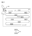
- FIG 1 shows the principle idea of the method invented. According to the method invented the Unmanned Aerial Vehicle UAV is guided along a predetermined flight path FP.
- the flight-path FP is chosen in a way that high resolution images IMG1 - IMG9 of the surrounding SUR of a potential wind turbine site PWTS are gathered by the Unmanned Aerial Vehicle UAV.
- the images IMG1-IMG9 are used to obtain an actual Digital Surface Model DSM of the surrounding SUR of the potential wind turbine site PWTS.
- the potential wind turbine site PWTS is evaluated based on the actual Digital Surface Model DSM in view to the wind-parameters there.
- the potential wind turbine site PWTS is evaluated based on the actual Digital Surface Model DSM in an additional view to other ambient parameters there, like the temperature-profile over the year, possible site-specific ice-loads, site-specific wind-loads, site-specific air moisture, site-specific salt-content in the air, etc.
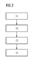
- FIG 2 shows the method invented as flow-chart. Even reference is made to FIG 1 .
- a flight path FP is defined in view to the surrounding SUR of the potential wind turbine site PWTS.
- the flight-path FP is chosen in a way that high resolution images IMG1 - IMG9 of the surrounding SUR of the potential wind turbine site PWTS are gathered by the Unmanned Aerial Vehicle UAV.
- a second step S2 the Unmanned Aerial Vehicle UAV is guided along the flight path FP and a number of images IMG1 - IMG9 is gathered by the Unmanned Aerial Vehicle UAV.
- a third step S3 the gathered images IMG1-IMG9 are processed to obtain an actual Digital Surface Model DSM of the surrounding SUR of the potential wind turbine site PWTS.
- a fourth step S4 the potential wind turbine site PWTS is evaluated based on the actual Digital Surface Model DSM.
- DSM Digital Surface Model
- a "Computational Fluid Dynamics, CFD"-software is used to determine, if the potential wind turbine site PWTS seems to be an optimum site for a wind turbine.
- the potential wind turbine site fulfills predetermined criteria the wind turbine is erected at this site afterwards.
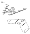
- FIG 3 shows two possible UAV to be used.
- One is named “Falcon-PARS", a kind of helicopter which is offered by the company “ISTS Americas Corporation” for example.
- the other one is a plane, offered by the company SENSEFLY, Switzerland, for example.
Landscapes
- Engineering & Computer Science (AREA)
- Life Sciences & Earth Sciences (AREA)
- Sustainable Development (AREA)
- Sustainable Energy (AREA)
- Chemical & Material Sciences (AREA)
- Combustion & Propulsion (AREA)
- Mechanical Engineering (AREA)
- General Engineering & Computer Science (AREA)
- Optical Radar Systems And Details Thereof (AREA)
- Wind Motors (AREA)
- Image Processing (AREA)
Abstract
Description
- The invention relates to a method to determine an optimum site for a wind turbine.
- It is known to use a so called "Digital Surface Model, DSM" to determine an optimum site for a wind turbine.
- The "Digital Surface Model, DSM" comprises the so called "Digital Terrain Model, DTM" and/or the so called "digital elevation model, DEM".
- The DSM comprises stored terrain elevation data for the surface of the earth. The data are used to create digital models of the earth-surface. The DSM is applied to land-use studies and is even used for flood modeling, drainage modeling or for geological purposes.
- The DSM is based on satellite-data, for example. It even may be based on the data of LIDAR-systems ("Light Detection And Ranging", LIDAR).
- There is always a large distance between the satellite and the earth or between the LIDAR-system and the earth. Thus the resolution of gathered 2D-images or 3D-images, being used for the DSM, is quite rough.
- Additionally the images of the satellite may be older than needed, thus the model-data do not contain new key features like buildings, trees, and the like.
- It is the aim of the invention, to provide an improved method for the determination of an optimum wind turbine site.
- This aim is reached by the features of claim 1.
- Preferred configurations are object of the dependent claims.
- According to the method invented a so called "Unmanned Aerial Vehicle, UAV" is guided along a predetermined flight path. The flight-path is chosen in a way that high resolution images (like pictures or maps) of the surrounding of a potential wind turbine site are gathered by the UAV.
- The images are used to obtain an actual "Digital Surface Model, DSM" of the surrounding of the potential wind turbine site.
- The potential wind turbine site is evaluated based on the actual Digital Surface Model in view to the wind-parameters there and even in view to other ambient parameters there.
- If the potential wind turbine site fulfills predetermined criteria the wind turbine is erected at this site afterwards.
- Preferably the UAV carries at least components of an optical camera-system or the whole optical camera-system. Or the UAV carries at least components of a LIDAR-system or the whole LIDAR-system preferably.
This components or systems addressed above are small, cheap and they are even quite lightweight. Thus they are quite applicable to be used on board of an UAV. - Preferably the images, gathered by the UAV, are combined with GPS-data. The GPS-data are gathered while the UAV follows the predetermined flight path. Thus each image is matched with its dedicated GPS-position to allow and enable a creation of a precise DSM.
- Preferably additional sensors or measuring devices are used to provide additional data for the DSM. They are preferably located on board of the UAV, too.
- Preferably the data of gyroscopes or accelerometers are gathered and converted to improve the quality of the resulting 2D-maps or to improve the quality of the resulting 3D-maps.
- Preferably a so called "Computational Fluid Dynamics, CFD"-software is used to determine the optimum site for a wind turbine.
- Preferably the gathered data of the UAV are uploaded via the Internet for further post-processing steps.
- With the method invented it is possible to capture data needed quite quick and cheap. The data can be gathered at any time and without the need for expensive components like satellites.
- Additionally an UAV is simple to operate and it is quite small in its dimensions. Thus there is no need for expensive ground-personal and there is no need for specific transportation.
- Another advantage is that the used data-models are quite actual compared with the available data gathered by satellites.
- The invention is shown in more detail by help of figures.
- The figures show preferred configurations and do not limit the scope of the invention. They even do not limit the scope of the claims.
- FIG 1
- shows the principle idea of the method invented,
- FIG 2
- shows the method invented as flow-chart, and
- FIG 3
- shows different UAV to be used for the method invented.
-
FIG 1 shows the principle idea of the method invented. According to the method invented the Unmanned Aerial Vehicle UAV is guided along a predetermined flight path FP. - The flight-path FP is chosen in a way that high resolution images IMG1 - IMG9 of the surrounding SUR of a potential wind turbine site PWTS are gathered by the Unmanned Aerial Vehicle UAV.
- The images IMG1-IMG9 are used to obtain an actual Digital Surface Model DSM of the surrounding SUR of the potential wind turbine site PWTS.
- The potential wind turbine site PWTS is evaluated based on the actual Digital Surface Model DSM in view to the wind-parameters there.
- Preferably the potential wind turbine site PWTS is evaluated based on the actual Digital Surface Model DSM in an additional view to other ambient parameters there, like the temperature-profile over the year, possible site-specific ice-loads, site-specific wind-loads, site-specific air moisture, site-specific salt-content in the air, etc.
- If the potential wind turbine site PWTS fulfills predetermined criteria a wind turbine is erected there afterwards.
-
FIG 2 shows the method invented as flow-chart. Even reference is made toFIG 1 . - In a first step S1 a flight path FP is defined in view to the surrounding SUR of the potential wind turbine site PWTS. The flight-path FP is chosen in a way that high resolution images IMG1 - IMG9 of the surrounding SUR of the potential wind turbine site PWTS are gathered by the Unmanned Aerial Vehicle UAV.
- In a second step S2 the Unmanned Aerial Vehicle UAV is guided along the flight path FP and a number of images IMG1 - IMG9 is gathered by the Unmanned Aerial Vehicle UAV.
- In a third step S3 the gathered images IMG1-IMG9 are processed to obtain an actual Digital Surface Model DSM of the surrounding SUR of the potential wind turbine site PWTS.
- In a fourth step S4 the potential wind turbine site PWTS is evaluated based on the actual Digital Surface Model DSM. Preferably a "Computational Fluid Dynamics, CFD"-software is used to determine, if the potential wind turbine site PWTS seems to be an optimum site for a wind turbine.
- If the potential wind turbine site fulfills predetermined criteria the wind turbine is erected at this site afterwards.
-
FIG 3 shows two possible UAV to be used. One is named "Falcon-PARS", a kind of helicopter which is offered by the company "ISTS Americas Corporation" for example. The other one is a plane, offered by the company SENSEFLY, Switzerland, for example.
Claims (11)
- Method to determine a site for a wind turbine,- where an unmanned aerial vehicle is guided along a predetermined flight path,- where the flight-path is chosen in a way that high resolution images of the surrounding of a potential wind turbine site are gathered by the unmanned aerial vehicle,- where the images are used to obtain an actual digital surface model of the surrounding of the potential wind turbine site,- where the potential wind turbine site is evaluated based on the actual digital surface model to determine, if the potential wind turbine site is an optimum wind turbine site.
- Method according claim 1, where the evaluation is done in view to wind-parameters at the potential wind turbine site.
- Method according to claim 1 or to claim 2, where the actual digital surface model of the surrounding of the potential wind turbine site is compared with predetermined criteria to determine, if a wind turbine is erected at this site afterwards or not.
- Method according to claim 1, where the unmanned aerial vehicle carries at least components of an optical camera-system or the whole optical camera-system, being used to gather the high resolution images.
- Method according to claim 1, where the unmanned aerial vehicle carries at least components of a LIDAR-system or the whole LIDAR-system, being used to gather the high resolution images.
- Method according to claim 1, where the images are combined with GPS-data, which are gathered by the unmanned aerial vehicle while the unmanned aerial vehicle follows the predetermined flight path.
- Method according to claim 6, where each image is matched with its dedicated GPS-position to achieve a precise digital surface model.
- Method according to claim 1 or to claim 7, where additional sensors or measuring devices are used asides the unmanned aerial vehicle to provide additional data for the digital surface model.
- Method according to claim 8, where a gyroscope or an accelerometer are used to gather additional data for the digital surface model.
- Method according to claim 1, where a Computational Fluid Dynamics-software is used to determine the optimum site for a wind turbine.
- Method according to claim 1, where the gathered images or where data, gathered by the unmanned aerial vehicle, are uploaded via the Internet to a computer for further processing steps.
Priority Applications (5)
| Application Number | Priority Date | Filing Date | Title |
|---|---|---|---|
| DK11167444.6T DK2527648T3 (en) | 2011-05-25 | 2011-05-25 | Method for determining a wind turbine location |
| EP11167444.6A EP2527648B1 (en) | 2011-05-25 | 2011-05-25 | Method to determine a site for a wind turbine |
| US13/472,535 US8804998B2 (en) | 2011-05-25 | 2012-05-16 | Method to determine a site for a wind turbine |
| CA2777864A CA2777864C (en) | 2011-05-25 | 2012-05-23 | Method to determine a site for a wind turbine |
| CN201210165587.2A CN102798379B (en) | 2011-05-25 | 2012-05-25 | For the method determining place for wind turbine |
Applications Claiming Priority (1)
| Application Number | Priority Date | Filing Date | Title |
|---|---|---|---|
| EP11167444.6A EP2527648B1 (en) | 2011-05-25 | 2011-05-25 | Method to determine a site for a wind turbine |
Publications (2)
| Publication Number | Publication Date |
|---|---|
| EP2527648A1 true EP2527648A1 (en) | 2012-11-28 |
| EP2527648B1 EP2527648B1 (en) | 2018-12-12 |
Family
ID=45992883
Family Applications (1)
| Application Number | Title | Priority Date | Filing Date |
|---|---|---|---|
| EP11167444.6A Not-in-force EP2527648B1 (en) | 2011-05-25 | 2011-05-25 | Method to determine a site for a wind turbine |
Country Status (5)
| Country | Link |
|---|---|
| US (1) | US8804998B2 (en) |
| EP (1) | EP2527648B1 (en) |
| CN (1) | CN102798379B (en) |
| CA (1) | CA2777864C (en) |
| DK (1) | DK2527648T3 (en) |
Cited By (2)
| Publication number | Priority date | Publication date | Assignee | Title |
|---|---|---|---|---|
| CN107240153A (en) * | 2017-06-16 | 2017-10-10 | 千寻位置网络有限公司 | Unmanned plane during flying safety zone based on DSM calculates display methods |
| EP3736440A1 (en) * | 2019-05-10 | 2020-11-11 | Siemens Gamesa Renewable Energy A/S | A method for computer-implemented analysis of a wind farm comprising a number of wind turbines |
Families Citing this family (6)
| Publication number | Priority date | Publication date | Assignee | Title |
|---|---|---|---|---|
| US20140012616A1 (en) * | 2012-07-04 | 2014-01-09 | EHSolution.com | Systems and methods for new location task completion and enterprise-wide project initiative tracking |
| US9336506B2 (en) * | 2014-05-02 | 2016-05-10 | Google Inc. | Machine-readable delivery platform for automated package delivery |
| BR112020008778B1 (en) | 2017-10-31 | 2023-11-28 | Agjunction Llc | TERRAIN MAPPING SYSTEM FOR A VEHICLE, NON-TRANSIENT AND TANGIBLE COMPUTER READABLE METHOD AND MEDIUM |
| CN110598752B (en) * | 2019-08-16 | 2023-04-18 | 深圳宇骏视觉智能科技有限公司 | Image classification model training method and system for automatically generating training data set |
| FR3111196B1 (en) * | 2020-06-08 | 2022-06-10 | Ifp Energies Now | Method for determining the components of the wind speed by means of a laser remote sensing sensor |
| CN121582275B (en) * | 2026-01-26 | 2026-04-21 | 内蒙古自治区生态环境科学研究院 | Wind driven generator shadow evaluation method and system based on three-dimensional terrain shielding judgment |
Citations (4)
| Publication number | Priority date | Publication date | Assignee | Title |
|---|---|---|---|---|
| GB2398841A (en) * | 2003-02-28 | 2004-09-01 | Qinetiq Ltd | Wind turbine control having a Lidar wind speed measurement apparatus |
| US20070073486A1 (en) * | 2005-09-26 | 2007-03-29 | Tillotson Brian J | Airborne weather profiler network |
| WO2009027509A1 (en) * | 2007-08-31 | 2009-03-05 | Vestas Wind Systems A/S | Wind turbine siting and maintenance prediction |
| EP2133712A1 (en) * | 2008-06-12 | 2009-12-16 | Ophir Corporation | Optical air data systems and methods |
Family Cites Families (6)
| Publication number | Priority date | Publication date | Assignee | Title |
|---|---|---|---|---|
| US8072584B2 (en) * | 2002-08-02 | 2011-12-06 | Ophir Corporation | Optical air data systems and methods |
| US8797550B2 (en) * | 2009-04-21 | 2014-08-05 | Michigan Aerospace Corporation | Atmospheric measurement system |
| WO2011085104A1 (en) * | 2010-01-06 | 2011-07-14 | Wind Products Inc. | Methods and systems for locating wind turbines |
| CN101968353B (en) * | 2010-09-29 | 2012-02-08 | 清华大学 | Laser probing and image identification based terrain tracking method for unmanned helicopter |
| US20120120230A1 (en) * | 2010-11-17 | 2012-05-17 | Utah State University | Apparatus and Method for Small Scale Wind Mapping |
| CN102506824B (en) * | 2011-10-14 | 2014-08-27 | 航天恒星科技有限公司 | Method for generating digital orthophoto map (DOM) by urban low altitude unmanned aerial vehicle |
-
2011
- 2011-05-25 DK DK11167444.6T patent/DK2527648T3/en active
- 2011-05-25 EP EP11167444.6A patent/EP2527648B1/en not_active Not-in-force
-
2012
- 2012-05-16 US US13/472,535 patent/US8804998B2/en active Active
- 2012-05-23 CA CA2777864A patent/CA2777864C/en active Active
- 2012-05-25 CN CN201210165587.2A patent/CN102798379B/en not_active Expired - Fee Related
Patent Citations (4)
| Publication number | Priority date | Publication date | Assignee | Title |
|---|---|---|---|---|
| GB2398841A (en) * | 2003-02-28 | 2004-09-01 | Qinetiq Ltd | Wind turbine control having a Lidar wind speed measurement apparatus |
| US20070073486A1 (en) * | 2005-09-26 | 2007-03-29 | Tillotson Brian J | Airborne weather profiler network |
| WO2009027509A1 (en) * | 2007-08-31 | 2009-03-05 | Vestas Wind Systems A/S | Wind turbine siting and maintenance prediction |
| EP2133712A1 (en) * | 2008-06-12 | 2009-12-16 | Ophir Corporation | Optical air data systems and methods |
Non-Patent Citations (1)
| Title |
|---|
| PALMA J M L M ET AL: "Linear and nonlinear models in wind resource assessment and wind turbine micro-siting in complex terrain", JOURNAL OF WIND ENGINEERING AND INDUSTRIAL AERODYNAMICS, ELSEVIER, AMSTERDAM, NL, vol. 96, no. 12, 1 December 2008 (2008-12-01), pages 2308 - 2326, XP024097881, ISSN: 0167-6105, [retrieved on 20080610], DOI: 10.1016/J.JWEIA.2008.03.012 * |
Cited By (3)
| Publication number | Priority date | Publication date | Assignee | Title |
|---|---|---|---|---|
| CN107240153A (en) * | 2017-06-16 | 2017-10-10 | 千寻位置网络有限公司 | Unmanned plane during flying safety zone based on DSM calculates display methods |
| EP3736440A1 (en) * | 2019-05-10 | 2020-11-11 | Siemens Gamesa Renewable Energy A/S | A method for computer-implemented analysis of a wind farm comprising a number of wind turbines |
| WO2020229085A1 (en) * | 2019-05-10 | 2020-11-19 | Siemens Gamesa Renewable Energy A/S | A method for computer-implemented analysis of a wind farm comprising a number of wind turbines |
Also Published As
| Publication number | Publication date |
|---|---|
| CA2777864C (en) | 2019-10-29 |
| EP2527648B1 (en) | 2018-12-12 |
| US20120300986A1 (en) | 2012-11-29 |
| US8804998B2 (en) | 2014-08-12 |
| CN102798379A (en) | 2012-11-28 |
| CN102798379B (en) | 2016-06-29 |
| CA2777864A1 (en) | 2012-11-25 |
| DK2527648T3 (en) | 2019-02-18 |
Similar Documents
| Publication | Publication Date | Title |
|---|---|---|
| US8804998B2 (en) | Method to determine a site for a wind turbine | |
| Bühler et al. | Photogrammetric reconstruction of homogenous snow surfaces in alpine terrain applying near-infrared UAS imagery | |
| Tang et al. | Drone remote sensing for forestry research and practices | |
| Morgenthal et al. | Quality assessment of unmanned aerial vehicle (UAV) based visual inspection of structures | |
| KR102379303B1 (en) | A method and system for on-site investigation of a disaster cause using a special vehicle equipped with an unmanned aerial vehicle | |
| Vallet et al. | Photogrammetric performance of an ultra light weight swinglet" UAV" | |
| Wakeford et al. | Combining thermal imaging with photogrammetry of an active volcano using UAV: an example from Stromboli, Italy | |
| Martinez et al. | UAS point cloud accuracy assessment using structure from motion–based photogrammetry and PPK georeferencing technique for building surveying applications | |
| EP3387399B1 (en) | Unmanned aerial system based thermal imaging and aggregation systems and methods | |
| JP2014137375A (en) | Methods for determining flight path | |
| Petrie | Commercial Operation of Lightweight | |
| Poirier et al. | Low altitude thermal survey by means of an automated unmanned aerial vehicle for the detection of archaeological buried structures | |
| Tulldahl et al. | Lidar on small UAV for 3D mapping | |
| Honkavaara et al. | Autonomous hyperspectral UAS photogrammetry for environmental monitoring applications | |
| Szabó et al. | Zooming on aerial survey | |
| Nugroho et al. | Development of a fixed wing unmanned aerial vehicle (UAV) for disaster area monitoring and mapping | |
| Ruzgienė et al. | The use of kinematic photogrammetry and LiDAR for reconstruction of a unique object with extreme topography: a case study of Dutchman’s Cap, Baltic seacoast, Lithuania | |
| Osborn et al. | Photogrammetry for forest inventory | |
| Gura et al. | Overview of the DJI ZENMUSE L1 Laser Scanner for Spatial Planning Purposes | |
| Rodríguez-Navarro et al. | Drones for architectural surveying. Their use in documenting Towers of the Valencian Coast | |
| Pavelka et al. | Creating of DSM based on RPAS measurement and accuracy testing | |
| Ruzgiene et al. | Photogrammetric processing of UAV imagery: Checking DTM | |
| Maguire | Using Unmanned Aerial Vehicles and" Structure from Motion" Software to Monitor Coastal Erosion in Southeast Florida | |
| Duffy | Coastal eye: monitoring coastal environments using lightweight drones | |
| Amigo et al. | UAV simulation for object detection and 3D reconstruction fusing 2D LiDAR and camera |
Legal Events
| Date | Code | Title | Description |
|---|---|---|---|
| PUAI | Public reference made under article 153(3) epc to a published international application that has entered the european phase |
Free format text: ORIGINAL CODE: 0009012 |
|
| AK | Designated contracting states |
Kind code of ref document: A1 Designated state(s): AL AT BE BG CH CY CZ DE DK EE ES FI FR GB GR HR HU IE IS IT LI LT LU LV MC MK MT NL NO PL PT RO RS SE SI SK SM TR |
|
| AX | Request for extension of the european patent |
Extension state: BA ME |
|
| RAP1 | Party data changed (applicant data changed or rights of an application transferred) |
Owner name: SIEMENS AKTIENGESELLSCHAFT |
|
| 17P | Request for examination filed |
Effective date: 20130419 |
|
| RAP1 | Party data changed (applicant data changed or rights of an application transferred) |
Owner name: SIEMENS AKTIENGESELLSCHAFT |
|
| STAA | Information on the status of an ep patent application or granted ep patent |
Free format text: STATUS: EXAMINATION IS IN PROGRESS |
|
| 17Q | First examination report despatched |
Effective date: 20180228 |
|
| REG | Reference to a national code |
Ref country code: DE Ref legal event code: R079 Ref document number: 602011054698 Country of ref document: DE Free format text: PREVIOUS MAIN CLASS: F03D0011000000 Ipc: F03D0080000000 |
|
| GRAP | Despatch of communication of intention to grant a patent |
Free format text: ORIGINAL CODE: EPIDOSNIGR1 |
|
| STAA | Information on the status of an ep patent application or granted ep patent |
Free format text: STATUS: GRANT OF PATENT IS INTENDED |
|
| RIC1 | Information provided on ipc code assigned before grant |
Ipc: F03D 17/00 20160101ALI20180702BHEP Ipc: F03D 80/00 20160101AFI20180702BHEP |
|
| INTG | Intention to grant announced |
Effective date: 20180726 |
|
| GRAS | Grant fee paid |
Free format text: ORIGINAL CODE: EPIDOSNIGR3 |
|
| GRAA | (expected) grant |
Free format text: ORIGINAL CODE: 0009210 |
|
| STAA | Information on the status of an ep patent application or granted ep patent |
Free format text: STATUS: THE PATENT HAS BEEN GRANTED |
|
| AK | Designated contracting states |
Kind code of ref document: B1 Designated state(s): AL AT BE BG CH CY CZ DE DK EE ES FI FR GB GR HR HU IE IS IT LI LT LU LV MC MK MT NL NO PL PT RO RS SE SI SK SM TR |
|
| REG | Reference to a national code |
Ref country code: GB Ref legal event code: FG4D |
|
| REG | Reference to a national code |
Ref country code: CH Ref legal event code: EP |
|
| REG | Reference to a national code |
Ref country code: AT Ref legal event code: REF Ref document number: 1076360 Country of ref document: AT Kind code of ref document: T Effective date: 20181215 |
|
| REG | Reference to a national code |
Ref country code: DE Ref legal event code: R096 Ref document number: 602011054698 Country of ref document: DE |
|
| REG | Reference to a national code |
Ref country code: IE Ref legal event code: FG4D |
|
| REG | Reference to a national code |
Ref country code: DK Ref legal event code: T3 Effective date: 20190211 |
|
| REG | Reference to a national code |
Ref country code: NL Ref legal event code: MP Effective date: 20181212 |
|
| REG | Reference to a national code |
Ref country code: LT Ref legal event code: MG4D |
|
| PG25 | Lapsed in a contracting state [announced via postgrant information from national office to epo] |
Ref country code: LT Free format text: LAPSE BECAUSE OF FAILURE TO SUBMIT A TRANSLATION OF THE DESCRIPTION OR TO PAY THE FEE WITHIN THE PRESCRIBED TIME-LIMIT Effective date: 20181212 Ref country code: ES Free format text: LAPSE BECAUSE OF FAILURE TO SUBMIT A TRANSLATION OF THE DESCRIPTION OR TO PAY THE FEE WITHIN THE PRESCRIBED TIME-LIMIT Effective date: 20181212 Ref country code: BG Free format text: LAPSE BECAUSE OF FAILURE TO SUBMIT A TRANSLATION OF THE DESCRIPTION OR TO PAY THE FEE WITHIN THE PRESCRIBED TIME-LIMIT Effective date: 20190312 Ref country code: NO Free format text: LAPSE BECAUSE OF FAILURE TO SUBMIT A TRANSLATION OF THE DESCRIPTION OR TO PAY THE FEE WITHIN THE PRESCRIBED TIME-LIMIT Effective date: 20190312 Ref country code: HR Free format text: LAPSE BECAUSE OF FAILURE TO SUBMIT A TRANSLATION OF THE DESCRIPTION OR TO PAY THE FEE WITHIN THE PRESCRIBED TIME-LIMIT Effective date: 20181212 Ref country code: LV Free format text: LAPSE BECAUSE OF FAILURE TO SUBMIT A TRANSLATION OF THE DESCRIPTION OR TO PAY THE FEE WITHIN THE PRESCRIBED TIME-LIMIT Effective date: 20181212 Ref country code: FI Free format text: LAPSE BECAUSE OF FAILURE TO SUBMIT A TRANSLATION OF THE DESCRIPTION OR TO PAY THE FEE WITHIN THE PRESCRIBED TIME-LIMIT Effective date: 20181212 |
|
| REG | Reference to a national code |
Ref country code: DE Ref legal event code: R081 Ref document number: 602011054698 Country of ref document: DE Owner name: SIEMENS GAMESA RENEWABLE ENERGY A/S, DK Free format text: FORMER OWNER: SIEMENS AKTIENGESELLSCHAFT, 80333 MUENCHEN, DE |
|
| RAP2 | Party data changed (patent owner data changed or rights of a patent transferred) |
Owner name: SIEMENS GAMESA RENEWABLE ENERGY A/S |
|
| REG | Reference to a national code |
Ref country code: AT Ref legal event code: MK05 Ref document number: 1076360 Country of ref document: AT Kind code of ref document: T Effective date: 20181212 |
|
| PG25 | Lapsed in a contracting state [announced via postgrant information from national office to epo] |
Ref country code: SE Free format text: LAPSE BECAUSE OF FAILURE TO SUBMIT A TRANSLATION OF THE DESCRIPTION OR TO PAY THE FEE WITHIN THE PRESCRIBED TIME-LIMIT Effective date: 20181212 Ref country code: AL Free format text: LAPSE BECAUSE OF FAILURE TO SUBMIT A TRANSLATION OF THE DESCRIPTION OR TO PAY THE FEE WITHIN THE PRESCRIBED TIME-LIMIT Effective date: 20181212 Ref country code: RS Free format text: LAPSE BECAUSE OF FAILURE TO SUBMIT A TRANSLATION OF THE DESCRIPTION OR TO PAY THE FEE WITHIN THE PRESCRIBED TIME-LIMIT Effective date: 20181212 Ref country code: GR Free format text: LAPSE BECAUSE OF FAILURE TO SUBMIT A TRANSLATION OF THE DESCRIPTION OR TO PAY THE FEE WITHIN THE PRESCRIBED TIME-LIMIT Effective date: 20190313 |
|
| PG25 | Lapsed in a contracting state [announced via postgrant information from national office to epo] |
Ref country code: NL Free format text: LAPSE BECAUSE OF FAILURE TO SUBMIT A TRANSLATION OF THE DESCRIPTION OR TO PAY THE FEE WITHIN THE PRESCRIBED TIME-LIMIT Effective date: 20181212 |
|
| PG25 | Lapsed in a contracting state [announced via postgrant information from national office to epo] |
Ref country code: IT Free format text: LAPSE BECAUSE OF FAILURE TO SUBMIT A TRANSLATION OF THE DESCRIPTION OR TO PAY THE FEE WITHIN THE PRESCRIBED TIME-LIMIT Effective date: 20181212 Ref country code: PL Free format text: LAPSE BECAUSE OF FAILURE TO SUBMIT A TRANSLATION OF THE DESCRIPTION OR TO PAY THE FEE WITHIN THE PRESCRIBED TIME-LIMIT Effective date: 20181212 Ref country code: CZ Free format text: LAPSE BECAUSE OF FAILURE TO SUBMIT A TRANSLATION OF THE DESCRIPTION OR TO PAY THE FEE WITHIN THE PRESCRIBED TIME-LIMIT Effective date: 20181212 Ref country code: PT Free format text: LAPSE BECAUSE OF FAILURE TO SUBMIT A TRANSLATION OF THE DESCRIPTION OR TO PAY THE FEE WITHIN THE PRESCRIBED TIME-LIMIT Effective date: 20190412 |
|
| PG25 | Lapsed in a contracting state [announced via postgrant information from national office to epo] |
Ref country code: IS Free format text: LAPSE BECAUSE OF FAILURE TO SUBMIT A TRANSLATION OF THE DESCRIPTION OR TO PAY THE FEE WITHIN THE PRESCRIBED TIME-LIMIT Effective date: 20190412 Ref country code: SK Free format text: LAPSE BECAUSE OF FAILURE TO SUBMIT A TRANSLATION OF THE DESCRIPTION OR TO PAY THE FEE WITHIN THE PRESCRIBED TIME-LIMIT Effective date: 20181212 Ref country code: RO Free format text: LAPSE BECAUSE OF FAILURE TO SUBMIT A TRANSLATION OF THE DESCRIPTION OR TO PAY THE FEE WITHIN THE PRESCRIBED TIME-LIMIT Effective date: 20181212 Ref country code: SM Free format text: LAPSE BECAUSE OF FAILURE TO SUBMIT A TRANSLATION OF THE DESCRIPTION OR TO PAY THE FEE WITHIN THE PRESCRIBED TIME-LIMIT Effective date: 20181212 Ref country code: EE Free format text: LAPSE BECAUSE OF FAILURE TO SUBMIT A TRANSLATION OF THE DESCRIPTION OR TO PAY THE FEE WITHIN THE PRESCRIBED TIME-LIMIT Effective date: 20181212 |
|
| REG | Reference to a national code |
Ref country code: DE Ref legal event code: R097 Ref document number: 602011054698 Country of ref document: DE |
|
| REG | Reference to a national code |
Ref country code: GB Ref legal event code: 732E Free format text: REGISTERED BETWEEN 20190822 AND 20190828 |
|
| PLBE | No opposition filed within time limit |
Free format text: ORIGINAL CODE: 0009261 |
|
| STAA | Information on the status of an ep patent application or granted ep patent |
Free format text: STATUS: NO OPPOSITION FILED WITHIN TIME LIMIT |
|
| PG25 | Lapsed in a contracting state [announced via postgrant information from national office to epo] |
Ref country code: SI Free format text: LAPSE BECAUSE OF FAILURE TO SUBMIT A TRANSLATION OF THE DESCRIPTION OR TO PAY THE FEE WITHIN THE PRESCRIBED TIME-LIMIT Effective date: 20181212 Ref country code: AT Free format text: LAPSE BECAUSE OF FAILURE TO SUBMIT A TRANSLATION OF THE DESCRIPTION OR TO PAY THE FEE WITHIN THE PRESCRIBED TIME-LIMIT Effective date: 20181212 |
|
| 26N | No opposition filed |
Effective date: 20190913 |
|
| REG | Reference to a national code |
Ref country code: CH Ref legal event code: PL |
|
| PG25 | Lapsed in a contracting state [announced via postgrant information from national office to epo] |
Ref country code: CH Free format text: LAPSE BECAUSE OF NON-PAYMENT OF DUE FEES Effective date: 20190531 Ref country code: LI Free format text: LAPSE BECAUSE OF NON-PAYMENT OF DUE FEES Effective date: 20190531 Ref country code: MC Free format text: LAPSE BECAUSE OF FAILURE TO SUBMIT A TRANSLATION OF THE DESCRIPTION OR TO PAY THE FEE WITHIN THE PRESCRIBED TIME-LIMIT Effective date: 20181212 |
|
| REG | Reference to a national code |
Ref country code: BE Ref legal event code: MM Effective date: 20190531 |
|
| PG25 | Lapsed in a contracting state [announced via postgrant information from national office to epo] |
Ref country code: LU Free format text: LAPSE BECAUSE OF NON-PAYMENT OF DUE FEES Effective date: 20190525 |
|
| PG25 | Lapsed in a contracting state [announced via postgrant information from national office to epo] |
Ref country code: TR Free format text: LAPSE BECAUSE OF FAILURE TO SUBMIT A TRANSLATION OF THE DESCRIPTION OR TO PAY THE FEE WITHIN THE PRESCRIBED TIME-LIMIT Effective date: 20181212 |
|
| PG25 | Lapsed in a contracting state [announced via postgrant information from national office to epo] |
Ref country code: IE Free format text: LAPSE BECAUSE OF NON-PAYMENT OF DUE FEES Effective date: 20190525 |
|
| PG25 | Lapsed in a contracting state [announced via postgrant information from national office to epo] |
Ref country code: BE Free format text: LAPSE BECAUSE OF NON-PAYMENT OF DUE FEES Effective date: 20190531 |
|
| PG25 | Lapsed in a contracting state [announced via postgrant information from national office to epo] |
Ref country code: FR Free format text: LAPSE BECAUSE OF NON-PAYMENT OF DUE FEES Effective date: 20190531 |
|
| PG25 | Lapsed in a contracting state [announced via postgrant information from national office to epo] |
Ref country code: CY Free format text: LAPSE BECAUSE OF FAILURE TO SUBMIT A TRANSLATION OF THE DESCRIPTION OR TO PAY THE FEE WITHIN THE PRESCRIBED TIME-LIMIT Effective date: 20181212 |
|
| PG25 | Lapsed in a contracting state [announced via postgrant information from national office to epo] |
Ref country code: MT Free format text: LAPSE BECAUSE OF FAILURE TO SUBMIT A TRANSLATION OF THE DESCRIPTION OR TO PAY THE FEE WITHIN THE PRESCRIBED TIME-LIMIT Effective date: 20181212 Ref country code: HU Free format text: LAPSE BECAUSE OF FAILURE TO SUBMIT A TRANSLATION OF THE DESCRIPTION OR TO PAY THE FEE WITHIN THE PRESCRIBED TIME-LIMIT; INVALID AB INITIO Effective date: 20110525 |
|
| PG25 | Lapsed in a contracting state [announced via postgrant information from national office to epo] |
Ref country code: MK Free format text: LAPSE BECAUSE OF FAILURE TO SUBMIT A TRANSLATION OF THE DESCRIPTION OR TO PAY THE FEE WITHIN THE PRESCRIBED TIME-LIMIT Effective date: 20181212 |
|
| PGFP | Annual fee paid to national office [announced via postgrant information from national office to epo] |
Ref country code: GB Payment date: 20220523 Year of fee payment: 12 Ref country code: DK Payment date: 20220523 Year of fee payment: 12 Ref country code: DE Payment date: 20220519 Year of fee payment: 12 |
|
| REG | Reference to a national code |
Ref country code: DE Ref legal event code: R082 Ref document number: 602011054698 Country of ref document: DE Representative=s name: SAUTHOFF, KARSTEN, DIPL.-ING. UNIV., DE |
|
| REG | Reference to a national code |
Ref country code: DE Ref legal event code: R119 Ref document number: 602011054698 Country of ref document: DE |
|
| REG | Reference to a national code |
Ref country code: DK Ref legal event code: EBP Effective date: 20230531 |
|
| GBPC | Gb: european patent ceased through non-payment of renewal fee |
Effective date: 20230525 |
|
| PG25 | Lapsed in a contracting state [announced via postgrant information from national office to epo] |
Ref country code: DK Free format text: LAPSE BECAUSE OF NON-PAYMENT OF DUE FEES Effective date: 20230531 Ref country code: DE Free format text: LAPSE BECAUSE OF NON-PAYMENT OF DUE FEES Effective date: 20231201 Ref country code: GB Free format text: LAPSE BECAUSE OF NON-PAYMENT OF DUE FEES Effective date: 20230525 |