EP2503287A2 - Collaborative navigation using conditional updates - Google Patents
Collaborative navigation using conditional updates Download PDFInfo
- Publication number
- EP2503287A2 EP2503287A2 EP12160185A EP12160185A EP2503287A2 EP 2503287 A2 EP2503287 A2 EP 2503287A2 EP 12160185 A EP12160185 A EP 12160185A EP 12160185 A EP12160185 A EP 12160185A EP 2503287 A2 EP2503287 A2 EP 2503287A2
- Authority
- EP
- European Patent Office
- Prior art keywords
- platform
- vehicle
- state
- covariance
- covariance elements
- Prior art date
- Legal status (The legal status is an assumption and is not a legal conclusion. Google has not performed a legal analysis and makes no representation as to the accuracy of the status listed.)
- Withdrawn
Links
Images

Classifications
-
- G—PHYSICS
- G01—MEASURING; TESTING
- G01C—MEASURING DISTANCES, LEVELS OR BEARINGS; SURVEYING; NAVIGATION; GYROSCOPIC INSTRUMENTS; PHOTOGRAMMETRY OR VIDEOGRAMMETRY
- G01C21/00—Navigation; Navigational instruments not provided for in groups G01C1/00 - G01C19/00
- G01C21/20—Instruments for performing navigational calculations
-
- G—PHYSICS
- G06—COMPUTING OR CALCULATING; COUNTING
- G06T—IMAGE DATA PROCESSING OR GENERATION, IN GENERAL
- G06T7/00—Image analysis
- G06T7/50—Depth or shape recovery
- G06T7/55—Depth or shape recovery from multiple images
- G06T7/593—Depth or shape recovery from multiple images from stereo images
-
- G—PHYSICS
- G06—COMPUTING OR CALCULATING; COUNTING
- G06T—IMAGE DATA PROCESSING OR GENERATION, IN GENERAL
- G06T2207/00—Indexing scheme for image analysis or image enhancement
- G06T2207/10—Image acquisition modality
- G06T2207/10016—Video; Image sequence
-
- G—PHYSICS
- G06—COMPUTING OR CALCULATING; COUNTING
- G06T—IMAGE DATA PROCESSING OR GENERATION, IN GENERAL
- G06T2207/00—Indexing scheme for image analysis or image enhancement
- G06T2207/30—Subject of image; Context of image processing
- G06T2207/30181—Earth observation
-
- G—PHYSICS
- G06—COMPUTING OR CALCULATING; COUNTING
- G06T—IMAGE DATA PROCESSING OR GENERATION, IN GENERAL
- G06T2207/00—Indexing scheme for image analysis or image enhancement
- G06T2207/30—Subject of image; Context of image processing
- G06T2207/30212—Military
-
- G—PHYSICS
- G06—COMPUTING OR CALCULATING; COUNTING
- G06T—IMAGE DATA PROCESSING OR GENERATION, IN GENERAL
- G06T2207/00—Indexing scheme for image analysis or image enhancement
- G06T2207/30—Subject of image; Context of image processing
- G06T2207/30241—Trajectory
-
- G—PHYSICS
- G06—COMPUTING OR CALCULATING; COUNTING
- G06T—IMAGE DATA PROCESSING OR GENERATION, IN GENERAL
- G06T2207/00—Indexing scheme for image analysis or image enhancement
- G06T2207/30—Subject of image; Context of image processing
- G06T2207/30248—Vehicle exterior or interior
- G06T2207/30252—Vehicle exterior; Vicinity of vehicle
Definitions
- Collaborative navigation systems allow two or more navigation systems to work together to produce improved navigation solutions.
- many autonomous unmanned aerial vehicles can operate and navigate in an environment in the application of surveillance, remote sensing, or rescue.
- these vehicles can cooperate to improve navigation by sharing information.
- the connections can be established by any measurement which allows the two vehicles to make estimates of the same state. Examples include ranging radio between the two moving platforms, which allow each unit to estimate the positions of both, or using the shared Simultaneous Localization and Mapping (SLAM) landmark states between the two platforms.
- SLAM Simultaneous Localization and Mapping
- a single vehicle integrated navigation system includes an inertial measurement unit and aiding sensors.
- the inertial measurement unit uses strap-down sensors mechanized as a strap-down unit.
- the aiding sensors may include a global position system (GPS) receiver, image based sensors, Doppler velocity sensors, or other sensors.
- GPS global position system
- a single vehicle integrated navigation system combines the data from the navigation states (such as position, velocity, and altitude) generated by the dynamic plant with the independent aiding sensor data in a Kalman filter algorithm.
- the navigation algorithm can be based on the Extended Kalman Filter (EKF) which provides, under certain assumptions, a consistent way to deal with the uncertainties associated with the movement and measurement processes.
- EKF Extended Kalman Filter
- the vehicle uses information from its own platform sensor, as well as that from other platforms, to enhance a navigation solution of all the platforms.
- the SLAM method is one way for the navigation, that is, the information obtained by a sensor on a mobile platform is processed to obtain an estimate of its own position while building a map of the environment.
- a method for collaborative navigation between two or more platforms comprises establishing a communication link between a first platform and a second platform, making a sensor measurement from the first platform, updating state and covariance elements of the first platform, and transmitting the updated state and covariance elements from the first platform to the second platform.
- a conditional update is performed on the second platform to compute a new estimate of state and covariance elements on the second platform, which takes into account the measurement from the first platform.
- the method further comprises making a sensor measurement from the second platform, updating state and covariance elements of the second platform, and transmitting the updated state and covariance elements from the second platform to the first platform.
- a conditional update is performed on the first platform to compute a new estimate of state and covariance elements on the first platform, which takes into account the measurement from the second platform.
- Figure 1 illustrates an exemplary application environment for collaborative navigation using conditional updates between collaborating platforms
- Figure 2 is a data flow diagram showing the data transfer necessary for making conditional updates between collaborating platforms.
- Figure 3 is a process flow diagram showing a conditional update data flow between two collaborating platforms.
- a method and system is provided for collaborative navigation using conditional updates.
- information is exchanged between two or more navigation platforms, in order to improve the quality of navigation estimates of all the platforms.
- the present method allows each platform to share its unique sensor information with the other platforms in a statistically sound way, resulting in improvement of the navigation quantity estimates of all the platforms.
- the navigation filters are distributed in among the available moving platforms. If there is no shared information, each platform works independently using only its own sensed data. If there is shared information, the interdependence between the platforms is established. The individual platform navigation system can then be integrated into the collaborative navigation network.
- a conditional update method is applied in the present technique to share information between two or more (multiple) vehicles to enable cooperative navigation between the vehicles. For example, in a scenario where there are two vehicles and two landmarks, the communication between the two vehicles is open, and both vehicles see both of the landmarks. The present approach provides for collaborative navigation between the two vehicles.
- the Bayesian conditional update uses the property of conditional independence. Two random variables x and y are conditionally independent given z when p ( x,y
- z ) p ( x
- y , z ) p( x
- the Bayesian conditional update uses this formulation to update and compute a new distribution for x given z ; y is not needed.
- the provided examples deal with linear, Gaussian problems with an Extended Kalman Filter mechanization. However the present approach is general and the Bayesian conditional update can also be applied to collaborative navigation with non-linear dynamics and/or non-Gaussian statistics, as well as other types of estimators, such as Particle or Unscented Kalman Filters.
- FIG. 1 illustrates an exemplary application environment 100 for collaborative navigation using conditional updates between collaborating platforms.
- three vehicles are collaborating to improve their navigation solutions, including a high altitude aircraft 110, a low altitude aircraft 112 such as an unmanned aerial vehicle (UAV), and a land vehicle 114.
- Radio ranging measurements 120 are made between each of the vehicles and cameras on the vehicles can observe common landmark features on the terrain.
- Communication links 122 also connect the vehicles.
- Each of the vehicles also has access to Digital Terrain Elevation Data (DTED) 124.
- the camera on aircraft 110 provides a field of view 126
- the camera on aircraft 112 provides a field of view 128. At some point in time, the fields of view 126 and 128 intersect to produce an overlapping field of view 130.
- DTED Digital Terrain Elevation Data
- the present approach applies the Bayesian conditional update method of information exchange to improve the solutions of a set of collaborating navigation systems.
- the conditional update method provides a way to maintain multiple submaps consistently in a Simultaneous Localization and Mapping (SLAM) system.
- SLAM Simultaneous Localization and Mapping
- Salient features of the environment or vehicle state components such as velocity or global attitude can be shared between local maps without affecting the posterior joining process or introducing any undesirable approximations in the final global map estimate.
- the overload cost introduced by the technique is minimal since building up local maps does not require any additional operations apart from the usual EKF steps.
- well-known data association techniques can be used in the usual manner. The initialization of the features is based on the inverse depth algorithm.
- the Pinies et al. paper describes the use of Bayesian conditional updates for SLAM map management in single platform navigation. The present approach applies this technique to collaboration between the multiple platforms.
- An individual collaborative filter is structured as a covariance form extended Kalman filter.
- States represented typically include the position, velocity, and attitude of each platform sharing information. Additional states, such as GPS pseudo-range biases, landmark positions, or ranges may be shared as the communication system allows. In general, increasing the number of shared states drives the distributed solution nearer to a globally optimal solution.
- the present system is capable of taking advantage of high bandwidth communication systems by increasing the amount of shared information, but flexibility in the set of shared states selection ensures that the algorithm will be feasible with relatively low-bandwidth communication.
- conditional covariance update allows information to be exchanged directly between separate but partially correlated Kalman filters.
- Conditional updates exploit conditional independence between states to use observations of one state to implicitly observe another with minimal data transfer.
- Conditional updates, routed through an ad-hoc network of collaborative Kalman filters, can be used to exchange diverse information between multiple disparate platforms.
- One example of the shared information can be the range measurement between the two platforms.
- Another example of the shared information can be the shared landmark when the two platforms observe the same object in the ground.
- FIG. 2 is a data flow diagram showing the data transfer necessary for making conditional updates between collaborating platforms.
- a first vehicle 210 is in operative communication with a second vehicle 220.
- Each of the vehicles 210 and 220 include a navigation filter 214 and 224, respectively, such as a Kalman filter.
- a communication link 230 between the navigation filters 214 and 224 provides for sharing of data obtained by each vehicle with the other vehicle.
- the shared data includes shared elements of the state vector (x') and covariance matrix (P') of each vehicle.
- filter 1 represents a combined navigation filter containing all the states for two navigation systems, while filters 2 and 3 each represent a single system navigation filter, that have some states ( “a” ) in common. Then, if states “ b “ and “ c " are conditionally independent given states “ a ", filter 1 may be replaced with filters 2 and 3 and still maintain consistent and optimal estimates of a , b, and c . Whenever either filter gains information (in the form of a measurement update), the information is passed on to the other filter by forcing the distribution of a to be the same in both filters and then computing the conditional distribution of the other states ( b or c ), given the new distribution of a.
- filter 3 gets a new measurement, y.
- filter 2 may also benefit from the measurement y by receiving a conditional update from filter 3 in the following process steps:
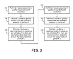
- FIG. 3 is a process flow diagram showing a conditional update data flow between two navigation platforms.
- platform 1 makes a measurement, and updates its own state and covariance data (block 310).
- Platform 1 transmits updated shared state and covariance elements to platform 2 (block 314).
- platform 2 performs a conditional update to compute a new estimate of its state and covariance, which takes into account the measurement on platform 1 (block 318).
- Platform 2 then makes a measurement, and updates its own state and covariance (block 322).
- platform 2 transmits updated shared state and covariance elements to platform 1 (block 326).
- Platform 1 then performs a conditional update to compute a new estimate of its state and covariance, which takes into account the measurement on platform 2 (block 330).
- a computer or processor used in the present system and method can be implemented using software, firmware, hardware, or any appropriate combination thereof, as known to one of skill in the art. These may be supplemented by, or incorporated in, specially-designed application-specific integrated circuits (ASICs) or field programmable gate arrays (FPGAs).
- ASICs application-specific integrated circuits
- FPGAs field programmable gate arrays
- the computer or processor can also include or function with software programs, firmware, or other computer readable instructions for carrying out various process tasks, calculations, and control functions used in the present method and system.
- the present methods can be implemented by computer executable instructions, such as program modules or components, which are executed by at least one processor.
- program modules include routines, programs, objects, data components, data structures, algorithms, and the like, which perform particular tasks or implement particular abstract data types.
- Instructions for carrying out the various process tasks, calculations, and generation of other data used in the operation of the methods described herein can be implemented in software, firmware, or other computer readable instructions. These instructions are typically stored on any appropriate computer program product that includes a computer readable medium used for storage of computer readable instructions or data structures. Such a computer readable medium can be any available media that can be accessed by a general purpose or special purpose computer or processor, or any programmable logic device.
- Suitable computer readable storage media may include, for example, non-volatile memory devices including semiconductor memory devices such as EPROM, EEPROM, or flash memory devices; magnetic disks such as internal hard disks or removable disks; magneto-optical disks; CDs, DVDs, Blu-ray discs, or other optical storage disks; nonvolatile ROM, RAM, and other like media; or any other media that can be used to carry or store desired program code in the form of computer executable instructions or data structures.
- non-volatile memory devices including semiconductor memory devices such as EPROM, EEPROM, or flash memory devices; magnetic disks such as internal hard disks or removable disks; magneto-optical disks; CDs, DVDs, Blu-ray discs, or other optical storage disks; nonvolatile ROM, RAM, and other like media; or any other media that can be used to carry or store desired program code in the form of computer executable instructions or data structures.
Landscapes
- Engineering & Computer Science (AREA)
- Radar, Positioning & Navigation (AREA)
- Remote Sensing (AREA)
- Physics & Mathematics (AREA)
- General Physics & Mathematics (AREA)
- Automation & Control Theory (AREA)
- Computer Vision & Pattern Recognition (AREA)
- Theoretical Computer Science (AREA)
- Navigation (AREA)
Abstract
Description
- Collaborative navigation systems allow two or more navigation systems to work together to produce improved navigation solutions. For example, many autonomous unmanned aerial vehicles can operate and navigate in an environment in the application of surveillance, remote sensing, or rescue. In a collaborative navigation system, these vehicles can cooperate to improve navigation by sharing information.
- Communication between two platforms is available sometime during the collaborative navigation procedure. The connections can be established by any measurement which allows the two vehicles to make estimates of the same state. Examples include ranging radio between the two moving platforms, which allow each unit to estimate the positions of both, or using the shared Simultaneous Localization and Mapping (SLAM) landmark states between the two platforms.
- A single vehicle integrated navigation system includes an inertial measurement unit and aiding sensors. For example, the inertial measurement unit uses strap-down sensors mechanized as a strap-down unit. The aiding sensors may include a global position system (GPS) receiver, image based sensors, Doppler velocity sensors, or other sensors. A single vehicle integrated navigation system combines the data from the navigation states (such as position, velocity, and altitude) generated by the dynamic plant with the independent aiding sensor data in a Kalman filter algorithm. For example, the navigation algorithm can be based on the Extended Kalman Filter (EKF) which provides, under certain assumptions, a consistent way to deal with the uncertainties associated with the movement and measurement processes.
- In collaborative navigation, the vehicle uses information from its own platform sensor, as well as that from other platforms, to enhance a navigation solution of all the platforms. The SLAM method is one way for the navigation, that is, the information obtained by a sensor on a mobile platform is processed to obtain an estimate of its own position while building a map of the environment.
- Previous methods for collaborative navigation have used a global centralized filter that includes all the vehicles' navigation states, the dynamic model for each vehicle, and the landmarks (when using SLAM techniques). The disadvantage of a global centralized filter is that each system must maintain estimates of all the states of all the systems. With large numbers of systems collaborating, this becomes computationally impractical. Centralized approaches are also more vulnerable to communication disruptions.
- A method for collaborative navigation between two or more platforms is provided. The method comprises establishing a communication link between a first platform and a second platform, making a sensor measurement from the first platform, updating state and covariance elements of the first platform, and transmitting the updated state and covariance elements from the first platform to the second platform. A conditional update is performed on the second platform to compute a new estimate of state and covariance elements on the second platform, which takes into account the measurement from the first platform. The method further comprises making a sensor measurement from the second platform, updating state and covariance elements of the second platform, and transmitting the updated state and covariance elements from the second platform to the first platform. A conditional update is performed on the first platform to compute a new estimate of state and covariance elements on the first platform, which takes into account the measurement from the second platform.
- Understanding that the drawings depict only exemplary embodiments and are not therefore to be considered limiting in scope, the exemplary embodiments will be described with additional specificity and detail through the use of the drawings, in which:
-
Figure 1 illustrates an exemplary application environment for collaborative navigation using conditional updates between collaborating platforms; -
Figure 2 is a data flow diagram showing the data transfer necessary for making conditional updates between collaborating platforms; and -
Figure 3 is a process flow diagram showing a conditional update data flow between two collaborating platforms. - In the following detailed description, reference is made to the accompanying drawings that form a part hereof, and in which is shown by way of illustration specific illustrative embodiments. It is to be understood, however, that other embodiments may be utilized and that logical, mechanical, and electrical changes may be made.
- A method and system is provided for collaborative navigation using conditional updates. In the present approach, information is exchanged between two or more navigation platforms, in order to improve the quality of navigation estimates of all the platforms. The present method allows each platform to share its unique sensor information with the other platforms in a statistically sound way, resulting in improvement of the navigation quantity estimates of all the platforms.
- There is no central filter for the collaborative navigation. The navigation filters are distributed in among the available moving platforms. If there is no shared information, each platform works independently using only its own sensed data. If there is shared information, the interdependence between the platforms is established. The individual platform navigation system can then be integrated into the collaborative navigation network.
- A conditional update method is applied in the present technique to share information between two or more (multiple) vehicles to enable cooperative navigation between the vehicles. For example, in a scenario where there are two vehicles and two landmarks, the communication between the two vehicles is open, and both vehicles see both of the landmarks. The present approach provides for collaborative navigation between the two vehicles.
- The Bayesian conditional update uses the property of conditional independence. Two random variables x and y are conditionally independent given z when p(x,y|z) = p(x|z)*p(y|z), where p is the probability. This expression is equivalent to p(x|y,z) = p(x|z). The Bayesian conditional update uses this formulation to update and compute a new distribution for x given z; y is not needed. The provided examples deal with linear, Gaussian problems with an Extended Kalman Filter mechanization. However the present approach is general and the Bayesian conditional update can also be applied to collaborative navigation with non-linear dynamics and/or non-Gaussian statistics, as well as other types of estimators, such as Particle or Unscented Kalman Filters.
-
Figure 1 illustrates anexemplary application environment 100 for collaborative navigation using conditional updates between collaborating platforms. As shown inFigure 1 , three vehicles are collaborating to improve their navigation solutions, including ahigh altitude aircraft 110, alow altitude aircraft 112 such as an unmanned aerial vehicle (UAV), and aland vehicle 114.Radio ranging measurements 120 are made between each of the vehicles and cameras on the vehicles can observe common landmark features on the terrain.Communication links 122 also connect the vehicles. Each of the vehicles also has access to Digital Terrain Elevation Data (DTED) 124. The camera onaircraft 110 provides a field ofview 126, and the camera onaircraft 112 provides a field ofview 128. At some point in time, the fields ofview view 130. - The present approach applies the Bayesian conditional update method of information exchange to improve the solutions of a set of collaborating navigation systems. The conditional update method provides a way to maintain multiple submaps consistently in a Simultaneous Localization and Mapping (SLAM) system. This is described in a paper by Pinies et al., Scalable SLAM Building Conditionally Independent Local Maps, Proceedings of the 2007 IEEE/RSJ International Conference on Intelligent Robots and Systems, pp. 3466-3471, San Diego, CA (2007), the disclosure of which is herein incorporated by reference. The Pinies et al. paper describes the use of local mapping algorithms in the context of Extended Kalman Filter (EKF) SLAM, but without the constraint of probabilistic independence between local maps. Salient features of the environment or vehicle state components such as velocity or global attitude can be shared between local maps without affecting the posterior joining process or introducing any undesirable approximations in the final global map estimate. The overload cost introduced by the technique is minimal since building up local maps does not require any additional operations apart from the usual EKF steps. As the algorithm works with covariance matrices, well-known data association techniques can be used in the usual manner. The initialization of the features is based on the inverse depth algorithm. The Pinies et al. paper describes the use of Bayesian conditional updates for SLAM map management in single platform navigation. The present approach applies this technique to collaboration between the multiple platforms.
- When communication between platforms is available, there is a sharing of data between the platforms. During a communication loss, the individual platforms will propagate the navigation information and maintain the state correlation status, and when communication is re-established, the collaborative navigation may be resumed.
- An individual collaborative filter is structured as a covariance form extended Kalman filter. States represented typically include the position, velocity, and attitude of each platform sharing information. Additional states, such as GPS pseudo-range biases, landmark positions, or ranges may be shared as the communication system allows. In general, increasing the number of shared states drives the distributed solution nearer to a globally optimal solution. The present system is capable of taking advantage of high bandwidth communication systems by increasing the amount of shared information, but flexibility in the set of shared states selection ensures that the algorithm will be feasible with relatively low-bandwidth communication.
- Using of the conditional covariance update allows information to be exchanged directly between separate but partially correlated Kalman filters. Conditional updates exploit conditional independence between states to use observations of one state to implicitly observe another with minimal data transfer. Conditional updates, routed through an ad-hoc network of collaborative Kalman filters, can be used to exchange diverse information between multiple disparate platforms.
- One example of the shared information can be the range measurement between the two platforms. Another example of the shared information can be the shared landmark when the two platforms observe the same object in the ground.
-
Figure 2 is a data flow diagram showing the data transfer necessary for making conditional updates between collaborating platforms. Afirst vehicle 210 is in operative communication with asecond vehicle 220. Each of thevehicles navigation filter communication link 230 between the navigation filters 214 and 224 provides for sharing of data obtained by each vehicle with the other vehicle. The shared data includes shared elements of the state vector (x') and covariance matrix (P') of each vehicle. - To further illustrate the present approach, three navigation filters are defined with the following state vectors and covariance matrices:


where a, b, and c are state sub-vectors, and b and c are conditionally independent given a. - In this example,
filter 1 represents a combined navigation filter containing all the states for two navigation systems, whilefilters 2 and 3 each represent a single system navigation filter, that have some states ("a") in common. Then, if states "b" and "c" are conditionally independent given states "a",filter 1 may be replaced withfilters 2 and 3 and still maintain consistent and optimal estimates of a, b, and c. Whenever either filter gains information (in the form of a measurement update), the information is passed on to the other filter by forcing the distribution of a to be the same in both filters and then computing the conditional distribution of the other states (b or c), given the new distribution of a. - To demonstrate how the update works, imagine that filter 3 gets a new measurement, y. Using the conventional Kalman update, filter 3 produces updated estimates of its state vector and covariance:

Then,filter 2 may also benefit from the measurement y by receiving a conditional update from filter 3 in the following process steps: - 1. Transmit shared elements of updated state and covariance (a', P')from filter 3 to filter 2.
- 2. Replace
filter 2 estimate of Pa with updated Pa' estimate from filter 3. - 3. replace
filter 2 estimate of a with updated a' estimate from filter 3. - 4. perform conditional state update on
filter 2 to produce updated b' estimate, where:
- 5. perform conditional covariance update on
filter 2 to produce updated Pb'and P'ba, where:

-
Figure 3 is a process flow diagram showing a conditional update data flow between two navigation platforms. Initially,platform 1 makes a measurement, and updates its own state and covariance data (block 310).Platform 1 then transmits updated shared state and covariance elements to platform 2 (block 314). Next,platform 2 performs a conditional update to compute a new estimate of its state and covariance, which takes into account the measurement on platform 1 (block 318).Platform 2 then makes a measurement, and updates its own state and covariance (block 322). Thereafter,platform 2 transmits updated shared state and covariance elements to platform 1 (block 326).Platform 1 then performs a conditional update to compute a new estimate of its state and covariance, which takes into account the measurement on platform 2 (block 330). - A computer or processor used in the present system and method can be implemented using software, firmware, hardware, or any appropriate combination thereof, as known to one of skill in the art. These may be supplemented by, or incorporated in, specially-designed application-specific integrated circuits (ASICs) or field programmable gate arrays (FPGAs). The computer or processor can also include or function with software programs, firmware, or other computer readable instructions for carrying out various process tasks, calculations, and control functions used in the present method and system.
- The present methods can be implemented by computer executable instructions, such as program modules or components, which are executed by at least one processor. Generally, program modules include routines, programs, objects, data components, data structures, algorithms, and the like, which perform particular tasks or implement particular abstract data types.
- Instructions for carrying out the various process tasks, calculations, and generation of other data used in the operation of the methods described herein can be implemented in software, firmware, or other computer readable instructions. These instructions are typically stored on any appropriate computer program product that includes a computer readable medium used for storage of computer readable instructions or data structures. Such a computer readable medium can be any available media that can be accessed by a general purpose or special purpose computer or processor, or any programmable logic device.
- Suitable computer readable storage media may include, for example, non-volatile memory devices including semiconductor memory devices such as EPROM, EEPROM, or flash memory devices; magnetic disks such as internal hard disks or removable disks; magneto-optical disks; CDs, DVDs, Blu-ray discs, or other optical storage disks; nonvolatile ROM, RAM, and other like media; or any other media that can be used to carry or store desired program code in the form of computer executable instructions or data structures.
- The present invention may be embodied in other specific forms without departing from its essential characteristics. The described embodiments are to be considered in all respects only as illustrative and not restrictive. The scope of the invention is therefore indicated by the appended claims rather than by the foregoing description. All changes that come within the meaning and range of equivalency of the claims are to be embraced within their scope.
Claims (10)
- A method for collaborative navigation between two or more platforms, the method comprising:establishing a communication link between a first platform and a second platform;making a sensor measurement from the first platform;updating state and covariance elements of the first platform;transmitting the updated state and covariance elements from the first platform to the second platform;performing a conditional update on the second platform to compute a new estimate of state and covariance elements on the second platform, which takes into account the measurement from the first platform;making a sensor measurement from the second platform;updating state and covariance elements of the second platform;transmitting the updated state and covariance elements from the second platform to the first platform; andperforming a conditional update on the first platform to compute a new estimate of state and covariance elements on the first platform, which takes into account the measurement from the second platform.
- The method of claim 1, wherein the sensor measurements are from at least one electro-optical sensor on each platform.
- The method of claim 1, further comprising:establishing a communication link between the first platform and a third platform; andestablishing a communication link between the second platform and the third platform.
- The method of claim 3, wherein the first platform is an aircraft at a first altitude.
- The method of claim 4, wherein the second platform is an aircraft at a second altitude different from the first altitude.
- The method of claim 5, wherein the third platform is a ground vehicle.
- The method of claim 6, wherein each of the platforms has access to digital terrain elevation data (DTED).
- The method of claim 3, further comprising taking radio ranging measurements between each of the platforms.
- A computer program product, comprising:a computer readable medium having instructions stored thereon executable by a processor to perform a method for collaborative navigation between two or more vehicles, the method comprising:establishing a communication link between a first vehicle and a second vehicle;making a sensor measurement from the first vehicle;updating state and covariance elements of the first vehicle;transmitting the updated state and covariance elements from the first vehicle to the second vehicle;performing a conditional update on the second vehicle to compute a new estimate of state and covariance elements on the second vehicle, which takes into account the measurement from the first vehicle;making a sensor measurement from the second vehicle;updating state and covariance elements of the second vehicle;transmitting the updated state and covariance elements from the second vehicle to the first vehicle; andperforming a conditional update on the first vehicle to compute a new estimate of state and covariance elements on the first vehicle, which takes into account the measurement from the second vehicle.
- A system for collaborative navigation between two or more platforms, the system comprising:a first platform; anda second platform in operative communication with the first platform;wherein the first platform and the second platform each comprise:at least one processor mounted on the platform;at least one electro-optical sensor mounted on the platform and operatively coupled to the processor;at least one navigation filter operatively coupled to the processor; anda memory unit operatively coupled to the processor and containing digital terrain elevation data (DTED), the memory unit including machine readable instructions executable by the processor to:establish a communication link between the first platform and the second platform;take an electro-optical sensor measurement from the first platform;update state and covariance elements of the first platform;transmit the updated state and covariance elements from the first platform to the second platform;perform a conditional update on the second platform to compute an estimate of state and covariance elements on the second platform, which takes into account the measurement from the first platform;take an electro-optical sensor measurement from the second platform;update state and covariance elements of the second platform;transmit the updated state and covariance elements from the second platform to the first platform; andperform a conditional update on the first platform to compute an estimate of state and covariance elements on the first platform, which takes into account the measurement from the second platform.
Applications Claiming Priority (1)
| Application Number | Priority Date | Filing Date | Title |
|---|---|---|---|
| US13/053,811 US8868323B2 (en) | 2011-03-22 | 2011-03-22 | Collaborative navigation using conditional updates |
Publications (2)
| Publication Number | Publication Date |
|---|---|
| EP2503287A2 true EP2503287A2 (en) | 2012-09-26 |
| EP2503287A3 EP2503287A3 (en) | 2012-12-05 |
Family
ID=45999566
Family Applications (1)
| Application Number | Title | Priority Date | Filing Date |
|---|---|---|---|
| EP12160185A Withdrawn EP2503287A3 (en) | 2011-03-22 | 2012-03-19 | Collaborative navigation using conditional updates |
Country Status (2)
| Country | Link |
|---|---|
| US (1) | US8868323B2 (en) |
| EP (1) | EP2503287A3 (en) |
Cited By (2)
| Publication number | Priority date | Publication date | Assignee | Title |
|---|---|---|---|---|
| EP3913389A1 (en) * | 2020-04-28 | 2021-11-24 | The Boeing Company | Estimator for determining updates to an estimated local state vector |
| EP3158485B1 (en) * | 2014-06-23 | 2023-05-03 | Sikorsky Aircraft Corporation | Cooperative safe landing area determination |
Families Citing this family (26)
| Publication number | Priority date | Publication date | Assignee | Title |
|---|---|---|---|---|
| US8660338B2 (en) | 2011-03-22 | 2014-02-25 | Honeywell International Inc. | Wide baseline feature matching using collobrative navigation and digital terrain elevation data constraints |
| EP2845071B1 (en) | 2012-04-30 | 2020-03-18 | The Trustees Of The University Of Pennsylvania | Three-dimensional manipulation of teams of quadrotors |
| US8442765B1 (en) | 2012-11-08 | 2013-05-14 | Honeywell International Inc. | Shared state selection and data exchange for collaborative navigation using conditionally independent parallel filters |
| US9104752B2 (en) * | 2012-11-16 | 2015-08-11 | Honeywell International Inc. | Data sharing among conditionally independent parallel filters |
| EP3074832A4 (en) | 2013-11-27 | 2017-08-30 | The Trustees Of The University Of Pennsylvania | Multi-sensor fusion for robust autonomous flight in indoor and outdoor environments with a rotorcraft micro-aerial vehicle (mav) |
| US10495464B2 (en) | 2013-12-02 | 2019-12-03 | The Regents Of The University Of California | Systems and methods for GNSS SNR probabilistic localization and 3-D mapping |
| JP6329642B2 (en) | 2013-12-10 | 2018-05-23 | エスゼット ディージェイアイ テクノロジー カンパニー リミテッドSz Dji Technology Co.,Ltd | Sensor fusion |
| CN114675671B (en) | 2014-09-05 | 2025-10-21 | 深圳市大疆创新科技有限公司 | Multi-sensor environment map construction |
| JP6181300B2 (en) | 2014-09-05 | 2017-08-16 | エスゼット ディージェイアイ テクノロジー カンパニー リミテッドSz Dji Technology Co.,Ltd | System for controlling the speed of unmanned aerial vehicles |
| EP3399381A1 (en) | 2014-09-05 | 2018-11-07 | SZ DJI Technology Co., Ltd. | Context-based flight mode selection |
| WO2016123201A1 (en) | 2015-01-27 | 2016-08-04 | The Trustees Of The University Of Pennsylvania | Systems, devices, and methods for robotic remote sensing for precision agriculture |
| US20170023659A1 (en) * | 2015-05-08 | 2017-01-26 | 5D Robotics, Inc. | Adaptive positioning system |
| US10365363B2 (en) | 2015-05-08 | 2019-07-30 | Humatics Corporation | Mobile localization using sparse time-of-flight ranges and dead reckoning |
| US10220510B2 (en) | 2015-06-02 | 2019-03-05 | Humatics Corporation | Unified collaborative environments |
| US10656282B2 (en) | 2015-07-17 | 2020-05-19 | The Regents Of The University Of California | System and method for localization and tracking using GNSS location estimates, satellite SNR data and 3D maps |
| US10037028B2 (en) | 2015-07-24 | 2018-07-31 | The Trustees Of The University Of Pennsylvania | Systems, devices, and methods for on-board sensing and control of micro aerial vehicles |
| WO2017095493A2 (en) | 2015-09-11 | 2017-06-08 | The Trustees Of The University Of Pennsylvania | Systems and methods for generating safe trajectories for multi-vehicle teams |
| US10386493B2 (en) | 2015-10-01 | 2019-08-20 | The Regents Of The University Of California | System and method for localization and tracking |
| GB2546241A (en) * | 2015-12-07 | 2017-07-19 | Atlantic Inertial Systems Ltd | Inertial navigation system |
| US10013884B2 (en) | 2016-07-29 | 2018-07-03 | International Business Machines Corporation | Unmanned aerial vehicle ad-hoc clustering and collaboration via shared intent and operator discovery |
| CN106568442B (en) * | 2016-10-18 | 2020-01-10 | 中冶华天南京电气工程技术有限公司 | Collaborative navigation filtering method with robust characteristic |
| US10684132B2 (en) | 2018-03-19 | 2020-06-16 | Here Global B.V. | Generation and update of a lane network graph model |
| FR3084151B1 (en) * | 2018-07-23 | 2020-06-19 | Safran | METHOD AND DEVICE FOR AIDING THE NAVIGATION OF A FLEET OF VEHICLES USING AN INVARIANT KALMAN FILTER |
| CN114494768B (en) | 2018-10-29 | 2025-09-26 | 赫克斯冈技术中心 | Monitoring system and method for monitoring facilities, and computer program product |
| CN111928851B (en) * | 2020-04-17 | 2023-12-12 | 中国科学院沈阳自动化研究所 | Multi-autonomous underwater robot cluster cooperative navigation method based on TMA technology |
| US10993121B1 (en) * | 2020-04-28 | 2021-04-27 | The Boeing Company | Estimator for determining updates to an estimated local state vector |
Family Cites Families (36)
| Publication number | Priority date | Publication date | Assignee | Title |
|---|---|---|---|---|
| WO1991019265A1 (en) | 1990-05-29 | 1991-12-12 | Axiom Innovation Limited | Machine vision stereo matching |
| US5179441A (en) | 1991-12-18 | 1993-01-12 | The United States Of America As Represented By The Administrator Of The National Aeronautics And Space Administration | Near real-time stereo vision system |
| US6807537B1 (en) | 1997-12-04 | 2004-10-19 | Microsoft Corporation | Mixtures of Bayesian networks |
| US6323807B1 (en) | 2000-02-17 | 2001-11-27 | Mitsubishi Electric Research Laboratories, Inc. | Indoor navigation with wearable passive sensors |
| GB0117541D0 (en) | 2001-07-19 | 2003-08-06 | Bae Systems Plc | Automatic registration of images in digital terrain elevation data |
| US6803878B2 (en) | 2002-05-13 | 2004-10-12 | Honeywell International Inc. | Methods and apparatus for terrain correlation |
| AU2003264048A1 (en) | 2002-08-09 | 2004-02-25 | Intersense, Inc. | Motion tracking system and method |
| US6882959B2 (en) | 2003-05-02 | 2005-04-19 | Microsoft Corporation | System and process for tracking an object state using a particle filter sensor fusion technique |
| US20050216182A1 (en) | 2004-03-24 | 2005-09-29 | Hussain Talib S | Vehicle routing and path planning |
| US20050246307A1 (en) | 2004-03-26 | 2005-11-03 | Datamat Systems Research, Inc. | Computerized modeling method and a computer program product employing a hybrid Bayesian decision tree for classification |
| US6885334B1 (en) | 2004-04-06 | 2005-04-26 | Honeywell International Inc. | Methods and systems for detecting forward obstacles |
| US7831094B2 (en) | 2004-04-27 | 2010-11-09 | Honda Motor Co., Ltd. | Simultaneous localization and mapping using multiple view feature descriptors |
| US7409293B2 (en) | 2004-06-03 | 2008-08-05 | Honeywell International Inc. | Methods and systems for enhancing accuracy of terrain aided navigation systems |
| US7240042B2 (en) | 2004-08-25 | 2007-07-03 | Siemens Medical Solutions Usa, Inc. | System and method for biological data analysis using a bayesian network combined with a support vector machine |
| EP1650686A3 (en) | 2004-09-17 | 2006-07-12 | Dacos Software GmbH | Method and system for simulating non-linear dependencies between physical entities and measured data on influencing factors, governed by a local/global modelling approach using objects with embedded probabilistic nets |
| US8666661B2 (en) | 2006-03-31 | 2014-03-04 | The Boeing Company | Video navigation |
| US8139109B2 (en) | 2006-06-19 | 2012-03-20 | Oshkosh Corporation | Vision system for an autonomous vehicle |
| US7698108B2 (en) | 2006-10-10 | 2010-04-13 | Haney Philip J | Parameterization of non-linear/non-Gaussian data distributions for efficient information sharing in distributed sensor networks |
| US7489268B2 (en) | 2007-01-08 | 2009-02-10 | Honeywell International Inc. | Methods and systems for producing an interpretive airborne radar map |
| US8126273B2 (en) | 2007-04-05 | 2012-02-28 | Siemens Corporation | Method for reconstructing three-dimensional images from two-dimensional image data |
| US7831391B2 (en) * | 2007-06-12 | 2010-11-09 | Palo Alto Research Center Incorporated | Using segmented cones for fast, conservative assessment of collision risk |
| IL191615A (en) | 2007-10-23 | 2015-05-31 | Israel Aerospace Ind Ltd | Method and system for producing tie points for use in stereo-matching of stereoscopic images and method for detecting differences in a photographed scenery between two time points |
| US7821453B2 (en) | 2007-12-20 | 2010-10-26 | Sarnoff Corporation | Distributed iterative multimodal sensor fusion method for improved collaborative localization and navigation |
| GB2458278A (en) | 2008-03-11 | 2009-09-16 | Geoffrey Cross | A method of recognising signs in images taken from video data |
| US8244469B2 (en) | 2008-03-16 | 2012-08-14 | Irobot Corporation | Collaborative engagement for target identification and tracking |
| US8363973B2 (en) | 2008-10-01 | 2013-01-29 | Fuji Xerox Co., Ltd. | Descriptor for image corresponding point matching |
| US8254697B2 (en) | 2009-02-02 | 2012-08-28 | Microsoft Corporation | Scalable near duplicate image search with geometric constraints |
| US8296056B2 (en) | 2009-04-20 | 2012-10-23 | Honeywell International Inc. | Enhanced vision system for precision navigation in low visibility or global positioning system (GPS) denied conditions |
| US9068847B2 (en) | 2009-04-22 | 2015-06-30 | Honeywell International Inc. | System and method for collaborative navigation |
| US8737961B2 (en) | 2009-09-23 | 2014-05-27 | Nokia Corporation | Method and apparatus for incrementally determining location context |
| FR2954494B1 (en) | 2009-12-18 | 2012-07-27 | Thales Sa | METHOD OF CALIBRATING A MEASURING INSTRUMENT OF AN OPTRONIC SYSTEM |
| FR2961897B1 (en) | 2010-06-25 | 2012-07-13 | Thales Sa | NAVIGATION FILTER FOR A FIELD CORRELATION NAVIGATION SYSTEM |
| US20120021764A1 (en) | 2010-07-23 | 2012-01-26 | Quantum Dimension Inc. | System and Method for Robust Navigation and Communication Via A Cooperative Ad-hoc Network |
| AU2011305154B2 (en) | 2010-09-24 | 2015-02-05 | Irobot Corporation | Systems and methods for VSLAM optimization |
| US8660338B2 (en) | 2011-03-22 | 2014-02-25 | Honeywell International Inc. | Wide baseline feature matching using collobrative navigation and digital terrain elevation data constraints |
| US9104752B2 (en) | 2012-11-16 | 2015-08-11 | Honeywell International Inc. | Data sharing among conditionally independent parallel filters |
-
2011
- 2011-03-22 US US13/053,811 patent/US8868323B2/en not_active Expired - Fee Related
-
2012
- 2012-03-19 EP EP12160185A patent/EP2503287A3/en not_active Withdrawn
Non-Patent Citations (1)
| Title |
|---|
| PINIES ET AL.: "Scalable SLAMBuilding Conditionally Independent Local Maps", PROCEEDINGS OF THE 2007 IEEE/RSJ INTERNATIONAL CONFERENCE ON INTELLIGENT ROBOTS AND SYSTEMS, 2007, pages 3466 - 3471 |
Cited By (3)
| Publication number | Priority date | Publication date | Assignee | Title |
|---|---|---|---|---|
| EP3158485B1 (en) * | 2014-06-23 | 2023-05-03 | Sikorsky Aircraft Corporation | Cooperative safe landing area determination |
| EP3913389A1 (en) * | 2020-04-28 | 2021-11-24 | The Boeing Company | Estimator for determining updates to an estimated local state vector |
| US11387883B2 (en) | 2020-04-28 | 2022-07-12 | The Boeing Company | Estimator for determining updates to an estimated local state vector |
Also Published As
| Publication number | Publication date |
|---|---|
| US8868323B2 (en) | 2014-10-21 |
| US20120245844A1 (en) | 2012-09-27 |
| EP2503287A3 (en) | 2012-12-05 |
Similar Documents
| Publication | Publication Date | Title |
|---|---|---|
| US8868323B2 (en) | Collaborative navigation using conditional updates | |
| CN115790571B (en) | Simultaneous positioning and map construction method based on heterogeneous unmanned system mutual observation | |
| US12529563B2 (en) | Vision-aided inertial navigation | |
| US11112252B2 (en) | Sensor fusion for accurate localization | |
| Ball et al. | Vision‐based obstacle detection and navigation for an agricultural robot | |
| US7840352B2 (en) | Method and system for autonomous vehicle navigation | |
| EP2730887B1 (en) | Shared state selection and data exchange for collaborative navigation using conditionally independent parallel filters | |
| US10768623B2 (en) | Drone path planning | |
| AU2018252237C1 (en) | Co-localisation | |
| US20180167452A1 (en) | Tools and methods for distributed spatial control of swarms via multiplex information networks | |
| US12277716B2 (en) | Cooperative aircraft navigation | |
| EP3627447B1 (en) | System and method of multirotor dynamics based online scale estimation for monocular vision | |
| Ahmed et al. | Factorized covariance intersection for scalable partial state decentralized data fusion | |
| US12498225B2 (en) | Chain | |
| Nemra et al. | Robust cooperative UAV visual SLAM | |
| Dourmashkin et al. | GPS-limited cooperative localization using scalable approximate decentralized data fusion | |
| Indelman | Navigation performance enhancement using online mosaicking | |
| Kenmogne et al. | Cooperative localization of drones by using interval methods | |
| Sharma et al. | Autonomous Drone Navigation in Closed Environments Using SLAM Techniques | |
| Taşan et al. | A Novel Collaborative UAV Navigation Algorithm for Multi-Agent Scenarios | |
| Hadji et al. | A review: Simultaneous localization and mapping algorithms | |
| Kannan | Development of a reference software platform for the Velodyne VLP-16 LiDARS | |
| Bresson et al. | Real-time decentralized monocular slam | |
| Nogueira et al. | An underwater cooperative navigation scheme | |
| Atik et al. | Cooperative Visual Inertial Odometry for Heterogeneous Swarm of Drones Navigating in Noisy Environments |
Legal Events
| Date | Code | Title | Description |
|---|---|---|---|
| PUAI | Public reference made under article 153(3) epc to a published international application that has entered the european phase |
Free format text: ORIGINAL CODE: 0009012 |
|
| 17P | Request for examination filed |
Effective date: 20120319 |
|
| AK | Designated contracting states |
Kind code of ref document: A2 Designated state(s): AL AT BE BG CH CY CZ DE DK EE ES FI FR GB GR HR HU IE IS IT LI LT LU LV MC MK MT NL NO PL PT RO RS SE SI SK SM TR |
|
| AX | Request for extension of the european patent |
Extension state: BA ME |
|
| PUAL | Search report despatched |
Free format text: ORIGINAL CODE: 0009013 |
|
| AK | Designated contracting states |
Kind code of ref document: A3 Designated state(s): AL AT BE BG CH CY CZ DE DK EE ES FI FR GB GR HR HU IE IS IT LI LT LU LV MC MK MT NL NO PL PT RO RS SE SI SK SM TR |
|
| AX | Request for extension of the european patent |
Extension state: BA ME |
|
| RIC1 | Information provided on ipc code assigned before grant |
Ipc: G01C 21/00 20060101ALI20121029BHEP Ipc: G06T 7/00 20060101AFI20121029BHEP |
|
| 17Q | First examination report despatched |
Effective date: 20130301 |
|
| RAP1 | Party data changed (applicant data changed or rights of an application transferred) |
Owner name: HONEYWELL INTERNATIONAL INC. |
|
| RIC1 | Information provided on ipc code assigned before grant |
Ipc: G06T 7/593 20170101AFI20171129BHEP |
|
| GRAP | Despatch of communication of intention to grant a patent |
Free format text: ORIGINAL CODE: EPIDOSNIGR1 |
|
| INTG | Intention to grant announced |
Effective date: 20180105 |
|
| STAA | Information on the status of an ep patent application or granted ep patent |
Free format text: STATUS: THE APPLICATION IS DEEMED TO BE WITHDRAWN |
|
| 18D | Application deemed to be withdrawn |
Effective date: 20180516 |
|
| RIC1 | Information provided on ipc code assigned before grant |
Ipc: G06T 7/593 20170101AFI20171129BHEP |