EP2372401A1 - Method for towing marine sensor streamers - Google Patents
Method for towing marine sensor streamers Download PDFInfo
- Publication number
- EP2372401A1 EP2372401A1 EP11155603A EP11155603A EP2372401A1 EP 2372401 A1 EP2372401 A1 EP 2372401A1 EP 11155603 A EP11155603 A EP 11155603A EP 11155603 A EP11155603 A EP 11155603A EP 2372401 A1 EP2372401 A1 EP 2372401A1
- Authority
- EP
- European Patent Office
- Prior art keywords
- streamer
- water
- operating
- survey vessel
- vessel
- Prior art date
- Legal status (The legal status is an assumption and is not a legal conclusion. Google has not performed a legal analysis and makes no representation as to the accuracy of the status listed.)
- Withdrawn
Links
- 238000000034 method Methods 0.000 title claims abstract description 11
- XLYOFNOQVPJJNP-UHFFFAOYSA-N water Substances O XLYOFNOQVPJJNP-UHFFFAOYSA-N 0.000 claims abstract description 17
- 230000003287 optical effect Effects 0.000 claims abstract description 5
- 230000015572 biosynthetic process Effects 0.000 description 1
- 230000015556 catabolic process Effects 0.000 description 1
- 239000004020 conductor Substances 0.000 description 1
- 238000013500 data storage Methods 0.000 description 1
- 238000006731 degradation reaction Methods 0.000 description 1
- 230000009189 diving Effects 0.000 description 1
- 230000000694 effects Effects 0.000 description 1
- 238000005755 formation reaction Methods 0.000 description 1
- 238000011084 recovery Methods 0.000 description 1
Images

Classifications
-
- G—PHYSICS
- G01—MEASURING; TESTING
- G01V—GEOPHYSICS; GRAVITATIONAL MEASUREMENTS; DETECTING MASSES OR OBJECTS; TAGS
- G01V1/00—Seismology; Seismic or acoustic prospecting or detecting
- G01V1/38—Seismology; Seismic or acoustic prospecting or detecting specially adapted for water-covered areas
- G01V1/3808—Seismic data acquisition, e.g. survey design
Definitions
- the invention relates generally to the field of towed marine geophysical survey systems. More specifically, the invention relates to methods and systems to enable towing sensor streamers at greater depth in the water than by using conventional towing devices.
- Marine geophysical sensor streamers for example seismic and/or electromagnetic sensor streamers are essentially long cables (several km in length) towed behind a vessel. Seismic streamers typically are operated at only a few meters water depth. Electromagnetic sensors may be operated at greater depths, on the order of several hundred to several thousand meters.
- towed sensing cables may have the advantage of real time signal communication with the recording vessel.
- a method for operating a geophysical sensor streamer in body of water includes operating a remotely operated vehicle coupled to a forward end of the streamer to tow the streamer in the water. Signals generated by sensors on the streamer are communicated substantially in real time to a recording unit on a survey vessel using at least one of electrical and optical cables in an umbilical cable connecting the remotely operable vehicle to the survey vessel.
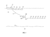
- FIG. 1 shows a vertical section view of one system according to the invention.
- Fig. 2 shows a plan view of a multiple streamer system.
- FIG. 1 shows a geophysical survey vessel 10 moving along the surface of a body of water 11 such as a lake or the ocean.
- the vessel may include equipment thereon, shown generally at 12 and referred to for convenience as a "recording system".
- the recording system 12 typically includes devices such as a data recording unit (not shown separately) for making a record with respect to time of signals generated by various sensors in the acquisition system.
- the recording system 12 also typically includes navigation equipment (not shown separately) to determine and record, at selected times, the geodetic position of the vessel 10.
- the vessel may tow one or more source cables 14.
- the source cable 14 may include thereon a seismic energy source 16 such as an air gun or array of such air guns.
- the source cable 16 may also include an electromagnetic energy source such as a pair of spaced apart electrodes 15. Operation of the sources is well known in the art and need not be repeated here.
- a sensor streamer cable 20 may be towed in the water 11 by a remotely operated vehicle (ROV) 18.
- the streamer cable 20 may include a plurality of geophysical sensors 22, non-limiting examples of which are hydrophones, geophones, accelerometers, magnetometers, wire coils, spaced apart electrodes, or combinations thereof.
- the sensors detect energy in response to seismic and/or electromagnetic energy imparted into the formations 24 below the water bottom 23.
- the ROV receives power for propulsion and control signals to change depth and direction (using diving planes 18A and rudder 18B) from an umbilical cable 17 connected from the ROV 18 to the vessel 10.
- the umbilical cable 17 also includes electrical and/or optical conductors that enable real time communication of signals detected by the sensors to the recording unit 12. This is in contrast to nodal based, ocean bottom or autonomously operated vehicle towing systems, which require data storage, storage equipment recovery and downloading of the recorded information.
- the present example enables data quality determination essentially while recording is underway, so that appropriate corrective action may be taken in the event of sensor degradation or failure.
- FIG. 2 shows an example of how this may be performed using streamer cables having additional navigation components to avoid tangling and fouling.
- Each of four sensor streamers 20 as explained with reference to FIG. 1 may be coupled at its forward end to a respective ROV 18.
- Each ROV may be coupled to the vessel 10 by a respective umbilical line 17 as explained above.
- the streamers 20 may be caused to remain in a selected pattern (e.g., such as parallel as shown) and to be responsive to the effects of water cross currents to maintain such pattern by the use of lateral force and control (LFD) devices 26 disposed at selected positions along the streamer.
- LFD lateral force and control
- Lateral distance between the streamers 20 at selected points therealong (to maintain the selected pattern) may be determined using an acoustic range finding system, components of which are shown at 27. See for example, U.S. Patent No. 7,376 , 045 issued to Falkenberg et al . and commonly owned with the present invention.
- Towing marine geophysical streamers using methods according to the invention may provide better control over streamer geometry at great water depth and may enable continuous signal communication with a vessel-borne recording system, thus reducing the possibility of sensor or streamer failure going unnoticed before an entire survey segment has been completed.
Landscapes
- Life Sciences & Earth Sciences (AREA)
- Physics & Mathematics (AREA)
- Oceanography (AREA)
- Engineering & Computer Science (AREA)
- Acoustics & Sound (AREA)
- Environmental & Geological Engineering (AREA)
- Geology (AREA)
- Remote Sensing (AREA)
- General Life Sciences & Earth Sciences (AREA)
- General Physics & Mathematics (AREA)
- Geophysics (AREA)
- Geophysics And Detection Of Objects (AREA)
Abstract
A method for operating a geophysical sensor streamer (20) in body of water includes operating a remotely operated vehicle (18) coupled to a forward end of the streamer to tow the streamer in the water. Signals generate by sensors (22) on the streamer (20) are communicated substantially in real time to a recording unit on a survey vessel using at least one of electrical and optical cables in an umbilical cable connecting the remotely operable vehicle to the survey vessel.
Description
- The invention relates generally to the field of towed marine geophysical survey systems. More specifically, the invention relates to methods and systems to enable towing sensor streamers at greater depth in the water than by using conventional towing devices.
- Marine geophysical sensor streamers, for example seismic and/or electromagnetic sensor streamers are essentially long cables (several km in length) towed behind a vessel. Seismic streamers typically are operated at only a few meters water depth. Electromagnetic sensors may be operated at greater depths, on the order of several hundred to several thousand meters.
- Deep operated seismic sensor cables, called "ocean bottom cables" that are placed on the water bottom are also known in the art. There are also individual sensor stations called "nodes" that have self contained signal recording devices. In either of the foregoing sensing systems, it is necessary to retrieve the system to the water surface. Thus, towed sensing cables may have the advantage of real time signal communication with the recording vessel.
- It has been impracticable to tow such sensing cables at depths of several hundred to several thousand meters from a surface vessel using conventional towing equipment because of the fact that the towing force is dissipated through friction along the extended lead in cable between the sensor cable and the vessel.
- There exists a need for a system and technique to tow marine geophysical sensor cables are relatively great water depth.
- A method for operating a geophysical sensor streamer in body of water includes operating a remotely operated vehicle coupled to a forward end of the streamer to tow the streamer in the water. Signals generated by sensors on the streamer are communicated substantially in real time to a recording unit on a survey vessel using at least one of electrical and optical cables in an umbilical cable connecting the remotely operable vehicle to the survey vessel.
- Other aspects and advantages of the invention will be apparent from the following description and the appended claims.
-
FIG. 1 shows a vertical section view of one system according to the invention. -
Fig. 2 shows a plan view of a multiple streamer system. -
FIG. 1 shows ageophysical survey vessel 10 moving along the surface of a body ofwater 11 such as a lake or the ocean. The vessel may include equipment thereon, shown generally at 12 and referred to for convenience as a "recording system". Therecording system 12 typically includes devices such as a data recording unit (not shown separately) for making a record with respect to time of signals generated by various sensors in the acquisition system. Therecording system 12 also typically includes navigation equipment (not shown separately) to determine and record, at selected times, the geodetic position of thevessel 10. - The vessel may tow one or
more source cables 14. Thesource cable 14 may include thereon aseismic energy source 16 such as an air gun or array of such air guns. Thesource cable 16 may also include an electromagnetic energy source such as a pair of spaced apartelectrodes 15. Operation of the sources is well known in the art and need not be repeated here. - In the present example, a
sensor streamer cable 20 may be towed in thewater 11 by a remotely operated vehicle (ROV) 18. Thestreamer cable 20 may include a plurality ofgeophysical sensors 22, non-limiting examples of which are hydrophones, geophones, accelerometers, magnetometers, wire coils, spaced apart electrodes, or combinations thereof. The sensors detect energy in response to seismic and/or electromagnetic energy imparted into theformations 24 below thewater bottom 23. - The ROV receives power for propulsion and control signals to change depth and direction (using
diving planes 18A andrudder 18B) from anumbilical cable 17 connected from theROV 18 to thevessel 10. Theumbilical cable 17 also includes electrical and/or optical conductors that enable real time communication of signals detected by the sensors to therecording unit 12. This is in contrast to nodal based, ocean bottom or autonomously operated vehicle towing systems, which require data storage, storage equipment recovery and downloading of the recorded information. The present example enables data quality determination essentially while recording is underway, so that appropriate corrective action may be taken in the event of sensor degradation or failure. - If it is desirable to operate more than one streamer at the same time,
FIG. 2 shows an example of how this may be performed using streamer cables having additional navigation components to avoid tangling and fouling. Each of foursensor streamers 20 as explained with reference toFIG. 1 may be coupled at its forward end to arespective ROV 18. Each ROV may be coupled to thevessel 10 by a respectiveumbilical line 17 as explained above. - In the present example, the
streamers 20 may be caused to remain in a selected pattern (e.g., such as parallel as shown) and to be responsive to the effects of water cross currents to maintain such pattern by the use of lateral force and control (LFD)devices 26 disposed at selected positions along the streamer. See, for example,U.S. Patent No. 6,144,342 issued to Bertheas et al . Lateral distance between thestreamers 20 at selected points therealong (to maintain the selected pattern) may be determined using an acoustic range finding system, components of which are shown at 27. See for example,U.S. Patent No. 7,376 ,045 issued to Falkenberg et al . and commonly owned with the present invention. - Towing marine geophysical streamers using methods according to the invention may provide better control over streamer geometry at great water depth and may enable continuous signal communication with a vessel-borne recording system, thus reducing the possibility of sensor or streamer failure going unnoticed before an entire survey segment has been completed.
Claims (5)
- A method for operating a geophysical sensor streamer in body of water, comprising:operating a remotely operated vehicle coupled to a forward end of the streamer to tow
the streamer in the water; andcommunicating signals generated by sensors on the streamer substantially in real time
to a recording unit on a survey vessel using at least one of electrical and optical cables in an umbilical cable connecting the remotely operable vehicle to the survey vessel. - The method of claim 1 further comprising:operating a plurality of remotely operated vehicles each connected to the vessel by a
respective umbilical cable, each vehicle towing a forward end of a marine geophysical sensor streamer;communicating signals generated by sensors on each streamer substantially in real
time to a recording unit on a survey vessel using at least one of electrical and optical cables in an umbilical cable connecting the remotely operable vehicle to the survey vessel; andsteering the streamers to maintain a selected pattern while moving in the water. - The method of claim 2 wherein the steering comprises operating a lateral force and depth control device.
- The method of claim 2 wherein the steering comprises operating an acoustic range finding device.
- The method of any of the preceding claims wherein the sensors comprise at least one of hydrophones, geophones, accelerometers, magnetometers, wire coils, spaced apart electrodes, of combinations thereof.
Applications Claiming Priority (1)
| Application Number | Priority Date | Filing Date | Title |
|---|---|---|---|
| US12/660,322 US20110205839A1 (en) | 2010-02-24 | 2010-02-24 | Method for towing marine sensor streamers |
Publications (1)
| Publication Number | Publication Date |
|---|---|
| EP2372401A1 true EP2372401A1 (en) | 2011-10-05 |
Family
ID=44065693
Family Applications (1)
| Application Number | Title | Priority Date | Filing Date |
|---|---|---|---|
| EP11155603A Withdrawn EP2372401A1 (en) | 2010-02-24 | 2011-02-23 | Method for towing marine sensor streamers |
Country Status (5)
| Country | Link |
|---|---|
| US (1) | US20110205839A1 (en) |
| EP (1) | EP2372401A1 (en) |
| AU (1) | AU2011200374A1 (en) |
| BR (1) | BRPI1100156A2 (en) |
| MX (1) | MX2011002075A (en) |
Cited By (3)
| Publication number | Priority date | Publication date | Assignee | Title |
|---|---|---|---|---|
| GB2492642A (en) * | 2011-07-05 | 2013-01-09 | Pgs Geophysical As | Geophysical survey method comprising towing streamers which are laterally spaced apart in deep water |
| US9239401B2 (en) | 2012-03-01 | 2016-01-19 | Pgs Geophysical As | Stationary source for marine electromagnetic surveying |
| CN106323244A (en) * | 2016-08-18 | 2017-01-11 | 广州地理研究所 | Reservoir capacity monitoring method and device based on unmanned aerial vehicle |
Families Citing this family (6)
| Publication number | Priority date | Publication date | Assignee | Title |
|---|---|---|---|---|
| US9013952B2 (en) * | 2010-09-17 | 2015-04-21 | Westerngeco L.L.C. | Marine seismic survey systems and methods using autonomously or remotely operated vehicles |
| US8994378B2 (en) | 2012-05-09 | 2015-03-31 | Pgs Geophysical As | Acquisition system and method for towed electromagnetic sensor cable and source |
| US10191170B2 (en) * | 2013-01-23 | 2019-01-29 | Westerngeco L.L.C. | Seismic data acquisition using water vehicles |
| US10281602B2 (en) | 2014-06-19 | 2019-05-07 | Westerngeco L.L.C. | System and method to acquire ultra-long offset seismic data for full waveform inversion (FWI) using unmanned marine vehicle (UMV) |
| US9921327B2 (en) * | 2015-03-25 | 2018-03-20 | Cgg Services Sas | Submerged front end buoy |
| AU2019275488B2 (en) | 2018-05-23 | 2022-03-03 | Bp Exploration Operating Company Limited | An autonomous data acquisition system and method |
Citations (6)
| Publication number | Priority date | Publication date | Assignee | Title |
|---|---|---|---|---|
| FR2496277A1 (en) * | 1980-12-11 | 1982-06-18 | Petroles Cie Francaise | Underwater seismic exploration system - uses self-propelled floats travelling adjacent to ship to tow seismic detectors and remotely controlled by mother |
| EP0154968A2 (en) * | 1984-03-12 | 1985-09-18 | Atlantic Richfield Company | Marine seismic prospecting method and system |
| US6144342A (en) | 1996-02-13 | 2000-11-07 | Thomson-Csf | Method for controlling the navigation of a towed linear acoustic antenna, and devices therefor |
| US20070223306A1 (en) * | 2006-03-10 | 2007-09-27 | Rune Toennessen | Marine seismic data acquisition systems and methods |
| US7376045B2 (en) | 2005-10-21 | 2008-05-20 | Pgs Geophysical As | System and method for determining positions of towed marine seismic streamers |
| WO2010104826A1 (en) * | 2009-03-09 | 2010-09-16 | Ion Geophysical Corporation | Marine seismic surveying in icy or obstructed waters |
Family Cites Families (6)
| Publication number | Priority date | Publication date | Assignee | Title |
|---|---|---|---|---|
| US5894450A (en) * | 1997-04-15 | 1999-04-13 | Massachusetts Institute Of Technology | Mobile underwater arrays |
| US6028817A (en) * | 1997-12-30 | 2000-02-22 | Western Atlas International, Inc. | Marine seismic system with independently powered tow vehicles |
| WO2007094846A2 (en) * | 2006-02-14 | 2007-08-23 | Exxonmobil Upstream Research Company | Source monitoring for electromagnetic surveying |
| NO332562B1 (en) * | 2008-07-04 | 2012-10-29 | Multifield Geophysics As | Marine seismic and electromagnetic streamer cable |
| US7974151B2 (en) * | 2008-09-17 | 2011-07-05 | Westerngeco L.L.C. | Cetacean protection system |
| US20100235100A1 (en) * | 2009-03-16 | 2010-09-16 | Bruce Alan Hobbs | Method for determining resistivity anisotropy from earth electromagnetic responses |
-
2010
- 2010-02-24 US US12/660,322 patent/US20110205839A1/en not_active Abandoned
-
2011
- 2011-01-28 AU AU2011200374A patent/AU2011200374A1/en not_active Abandoned
- 2011-02-22 BR BRPI1100156-9A patent/BRPI1100156A2/en not_active Application Discontinuation
- 2011-02-23 EP EP11155603A patent/EP2372401A1/en not_active Withdrawn
- 2011-02-24 MX MX2011002075A patent/MX2011002075A/en not_active Application Discontinuation
Patent Citations (6)
| Publication number | Priority date | Publication date | Assignee | Title |
|---|---|---|---|---|
| FR2496277A1 (en) * | 1980-12-11 | 1982-06-18 | Petroles Cie Francaise | Underwater seismic exploration system - uses self-propelled floats travelling adjacent to ship to tow seismic detectors and remotely controlled by mother |
| EP0154968A2 (en) * | 1984-03-12 | 1985-09-18 | Atlantic Richfield Company | Marine seismic prospecting method and system |
| US6144342A (en) | 1996-02-13 | 2000-11-07 | Thomson-Csf | Method for controlling the navigation of a towed linear acoustic antenna, and devices therefor |
| US7376045B2 (en) | 2005-10-21 | 2008-05-20 | Pgs Geophysical As | System and method for determining positions of towed marine seismic streamers |
| US20070223306A1 (en) * | 2006-03-10 | 2007-09-27 | Rune Toennessen | Marine seismic data acquisition systems and methods |
| WO2010104826A1 (en) * | 2009-03-09 | 2010-09-16 | Ion Geophysical Corporation | Marine seismic surveying in icy or obstructed waters |
Cited By (5)
| Publication number | Priority date | Publication date | Assignee | Title |
|---|---|---|---|---|
| GB2492642A (en) * | 2011-07-05 | 2013-01-09 | Pgs Geophysical As | Geophysical survey method comprising towing streamers which are laterally spaced apart in deep water |
| GB2492642B (en) * | 2011-07-05 | 2014-10-15 | Pgs Geophysical As | Towing methods and systems for geophysical surveys |
| US8976623B2 (en) | 2011-07-05 | 2015-03-10 | POS Geophysical AS | Towing methods and systems for geophysical surveys |
| US9239401B2 (en) | 2012-03-01 | 2016-01-19 | Pgs Geophysical As | Stationary source for marine electromagnetic surveying |
| CN106323244A (en) * | 2016-08-18 | 2017-01-11 | 广州地理研究所 | Reservoir capacity monitoring method and device based on unmanned aerial vehicle |
Also Published As
| Publication number | Publication date |
|---|---|
| BRPI1100156A2 (en) | 2012-07-31 |
| MX2011002075A (en) | 2011-08-30 |
| AU2011200374A1 (en) | 2011-09-08 |
| US20110205839A1 (en) | 2011-08-25 |
Similar Documents
| Publication | Publication Date | Title |
|---|---|---|
| EP2372401A1 (en) | Method for towing marine sensor streamers | |
| EP2360496B1 (en) | Tension management control system and methods used with towed marine sensor arrays | |
| US20240418893A1 (en) | Long Offset Acquisition | |
| US9013952B2 (en) | Marine seismic survey systems and methods using autonomously or remotely operated vehicles | |
| US8391101B2 (en) | Marine seismic acquisition with controlled streamer flaring | |
| US8400871B2 (en) | Seafloor-following streamer | |
| EP2821814B1 (en) | Variable depth multicomponent sensor streamer | |
| MX2011007175A (en) | Methods for gathering marine geophysical data. | |
| US10328997B2 (en) | Subsurface seismic deployment system and method | |
| AU2015238805B2 (en) | Electrically isolated streamer section | |
| US8787111B2 (en) | Devices and methods for positioning TOWs in marine seismic systems | |
| US12072461B2 (en) | Modified simultaneous long-offset acquisition with improved low frequency performance for full wavefield inversion | |
| US20110242940A1 (en) | Noise suppression by adaptive speed regulation of towed marine geophysical streamer | |
| US9885587B2 (en) | Heading sensor for deflector angle of attack estimation | |
| CA2730813A1 (en) | Method for towing marine sensor streamers | |
| AU2014201399B2 (en) | Wing for wide tow of geophysical survey sources |
Legal Events
| Date | Code | Title | Description |
|---|---|---|---|
| PUAI | Public reference made under article 153(3) epc to a published international application that has entered the european phase |
Free format text: ORIGINAL CODE: 0009012 |
|
| AK | Designated contracting states |
Kind code of ref document: A1 Designated state(s): AL AT BE BG CH CY CZ DE DK EE ES FI FR GB GR HR HU IE IS IT LI LT LU LV MC MK MT NL NO PL PT RO RS SE SI SK SM TR |
|
| AX | Request for extension of the european patent |
Extension state: BA ME |
|
| STAA | Information on the status of an ep patent application or granted ep patent |
Free format text: STATUS: THE APPLICATION IS DEEMED TO BE WITHDRAWN |
|
| 18D | Application deemed to be withdrawn |
Effective date: 20120406 |