EP2211324B1 - System and method for detecting and preventing runway incursion, excursion and confusion - Google Patents
System and method for detecting and preventing runway incursion, excursion and confusion Download PDFInfo
- Publication number
- EP2211324B1 EP2211324B1 EP10151471.9A EP10151471A EP2211324B1 EP 2211324 B1 EP2211324 B1 EP 2211324B1 EP 10151471 A EP10151471 A EP 10151471A EP 2211324 B1 EP2211324 B1 EP 2211324B1
- Authority
- EP
- European Patent Office
- Prior art keywords
- mobile platform
- operating
- area
- vehicle
- designated area
- Prior art date
- Legal status (The legal status is an assumption and is not a legal conclusion. Google has not performed a legal analysis and makes no representation as to the accuracy of the status listed.)
- Active
Links
Images
Classifications
-
- G—PHYSICS
- G08—SIGNALLING
- G08G—TRAFFIC CONTROL SYSTEMS
- G08G5/00—Traffic control systems for aircraft
- G08G5/50—Navigation or guidance aids
- G08G5/51—Navigation or guidance aids for control when on the ground, e.g. taxiing or rolling
-
- G—PHYSICS
- G08—SIGNALLING
- G08G—TRAFFIC CONTROL SYSTEMS
- G08G5/00—Traffic control systems for aircraft
- G08G5/80—Anti-collision systems
Definitions
- the present disclosure relates to systems and methods for monitoring the traffic of vehicles in a predetermined area, and in one example to a system and method for monitoring and predicting incursion, excursion and confusion events of airborne mobile platforms while same are operating on the ground at an airfield or airport.
- a runway incursion as "any occurrence at an aerodrome involving the incorrect presence of an aircraft, vehicle or person on the protected area of a surface designated for the landing and take-off of aircraft.”
- the FAA has adopted the ICAO definition as "any unauthorized intrusion onto a runway, regardless of whether or not an aircraft presents a potential conflict.”
- the FAA defines an "Excursion” as when “an aircraft uncontrollably leaves a runway end, or side, usually during landing, but also during takeoffs, especially following an abort.”
- a "Confusion” incident is defined as an incident involving a single aircraft when the aircraft makes “the unintentional use of the wrong runway, taxiway, or airport surface for landing or take-off.”
- monitoring is important to prevent accidental incursions, excursions and confusion when multiple aircraft are attempting to use runways or taxi areas.
- Such systems attempt to provide timely advisories to the flight crew during taxi, takeoff, final approach, landing and rollout. This added situational awareness helps pilots avoid runway incursion and other kinds of on-ground accidents.
- US 2008/0186207 relates to a device comprising a set of information sources for determining the active values of a plurality of parameters of an aeroplane, calculating means for determining, by means of said active values, a first position corresponding to a position which is extrapolated from the nose of the aeroplane following a particular time interval from the current instant.
- the device also comprises a database provided with at least one pre-determined unauthorised zone of the airport, comparison means for comparing said first position to said pre-determined unauthorised zone of the airport, and warning means for emitting at least one warning signal if the first position is located in the unauthorised zone.
- the present disclosure relates to a method for predicting the occurrence of an undesired operating event for a mobile platform operating within a designated area.
- the method is implemented using a system for monitoring operation of a mobile platform
- the method comprises: obtaining a plurality of parameters including a position of said mobile platform within said designated area, a velocity of said mobile platform, an acceleration of said mobile platform, and a time associated with said position, and velocity of said mobile platform for determining a kinematic motion of said mobile platform while said mobile platform is operating within said designated area; obtaining information related to surface geometry of said designated area; using said information related to surface geometry to determine physical constraints within said designated area that limit operation of said mobile platform within said designated area; using said plurality of parameters to determine a kinematic motion of said mobile platform within said designated area; using said kinematic motion of said mobile platform and said physical constraints to predict if motion of said mobile platform will cause said mobile platform to incur an undesired operating event; and generating an alert to a crew member on said mobile platform when said unde
- the present disclosure may relate to construction related to the invention there is provided a method for predicting the occurrence of an undesired operating event for a mobile platform operating within a designated area.
- the method may comprise: obtaining and using a plurality of operating parameters of the mobile platform to determine a kinematic motion of the mobile platform while the mobile platform is operating within the designated area; obtaining and using a plurality of operating parameters of a vehicle operating within the designated area, and remote from the mobile platform, to determine a kinematic motion of the vehicle; obtaining information related to surface geometry of the designated area; using the information related to surface geometry to determine physical constraints within the designated area that limit operation of at least one of the mobile platforms and the vehicle within the designated area: using the kinematic motions of the mobile platform and the vehicle, and the physical constraints, to predict the occurrence of an undesired operating event involving the mobile platform and the vehicle; and generating an alert to one of an individual on-board the mobile platform and a facility remote from the mobile platform when the undesired operating event is predicted
- the present disclosure relates to a system arranged to monitor operation of a mobile platform within a designated operating area and predicting the occurrence of an undesired operating event, the system comprising: a database on-board said mobile platform arranged to contain information useful for determining kinematic motion of said mobile platform within said designated operating area, the information useful for determining kinematic motion of said mobile platform including a position of said mobile platform within the designated operating area, a velocity of said mobile platform, and a time associated with said position, velocity, and acceleration of said mobile platform; a database remote from said mobile platform arranged to contain information relating to physical characteristics of said designated operating area; an information source remote from said mobile platform arranged to supply the position information concerning said mobile platform; and a processor carried on-board said mobile platform arranged to: obtain information from said database on-board said mobile platform, said database remote from said mobile platform and said information source to predict the occurrence of said undesired operating event; and generating an alert to a crew member on said mobile platform when said undesired operating event is
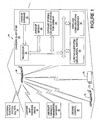
- the designated area is shown as airport 12 and a mobile platform 14, which will be referred to throughout as "aircraft 14", and may also be termed as the "ownship", is operating within the airport 12 boundary.
- the “boundary” in this instance is not limited to the airport physical boundary but also includes the airspace used for approach and takeoff or any other airspace within close proximity of the airport.
- the aircraft 14 may be operating on the ground, such as on a runway or taxiway, or parked at a gate during boarding or de-planeing.
- the aircraft 14 may also be approaching a runway during a landing operation or moving down a runway during a take-off operation.
- any type of operation of the aircraft 14 within the boundaries of the airport 12 is considered to be within the scope of the present disclosure.
- ground vehicles such as other aircraft 16, and various ground vehicles 18, are also operating within the boundaries of the airport.
- ground vehicles may be baggage transport vehicles, refueling vehicles, security or fire safety vehicles, etc.
- Often dozens or more vehicles both aircraft and ground vehicles will be moving about simultaneously at the airport 12.
- An "undesired event” or “undesired encounter”, as used herein, may mean an "incursion”, an “excursion”, or a "confusion event".
- a runway incursion may involve two or more vehicles coming within an unacceptably close proximity to one another on a runway surface, or one vehicle entering an area of the airport 12, for example a runway, where it is not permitted.
- An excursion may involve any vehicle uncontrollably leaving a designated area where it is expected to be operating, for example an aircraft leaving a runway and entering a grassy area adjacent to the runway.
- a confusion event could be an aircraft taking off from a taxiway or the wrong runway. All of these events may be termed for simplicity an "undesired event".
- the system 10 involves an on-board subsystem 20 that is carried on the aircraft 14.
- the on-board subsystem 20 may comprise a processor 22, a database 24 for storing equations of motion of the ownship, an ownship database 26, ownship sensors 28, a wireless communications transceiver 30 and a visual/aural alert subsystem 32.
- the reference to "ownship” simply means equipment or operating parameters that are dedicated to the aircraft 14.
- the ownship database 26 is used to store kinematic parameters that are required to calculate the kinematic motion (i.e., acceleration (a), velocity (v), displacement (s) and time (t)) of the aircraft 14. Some of this information may be obtained from the ownship sensors 28 (e.g., vehicle, speed, heading, etc.) that are carried on the aircraft 14.
- the wireless communications transceiver 30 may be used to obtain additional information needed or helpful in predicting incursion or excursion events, for example information on the real time position of the aircraft 14 from an external position system 34 such as a GPS satellite.
- the transceiver 30 may also be used to wirelessly access an airport map database 36 that contains a detailed map of the airport 12 ground surface including runways, taxiways, buildings, etc.
- the transceiver 30 may be used to access and obtain information from an aircraft kinematic parameters database 38 that provides real time kinematic parameter information concerning the movement (i.e., velocity and/or acceleration) of all other vehicles operating within the airport 12 boundary.
- the transceiver 30 may also be used to wirelessly communicate with the ground control tower 40 to obtain any other information that may be useful to the on-board subsystem 20 in predicting an incursion, an excursion or a confusion event such as runway and taxiway closures or changes, runway conditions (weather or construction related), and taxi-way instructions. Any incursions, excursions or confusion events that the processor 22 predicts may be indicated to the crew members of the aircraft 14 via an alerting subsystem 32.
- the alerting subsystem 32 may include one or more visual and/or aural alerts that apprise the crew members (e.g. pilot and/or co-pilot) of a predicted, impending incursion, excursion or confusion event involving the aircraft 14.
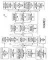
- a flow diagram 100 is shown illustrating various operations that may be performed by the on-board subsystem 20 in monitoring and predicting an undesired event (i.e., excursion, incursion or confusion event).
- the processor 22 may initialize the on-board subsystem 20 using the ownship database 26. This operation provides the kinematic parameters (e.g., aircraft 14 acceleration, velocity, displacement and time) needed to calculate kinematic motion.
- the processor 22 may obtain the updated current taxi and take-off plan from the ground control 40.
- the processor 22 may calculate external constraints, for example surface geometry of the airport 12, using information obtained from the airport map database 36.
- traffic i.e., other aircraft or land vehicles
- traffic on nonadjacent surfaces that do not lead to a surface adjacent the aircraft 14 in less than one intersection may not be considered "traffic of interest" because at least two turns would be required by the traffic to intercept the aircraft 14.
- all traffic of interest, relative to the aircraft 14, may be thought of as any traffic (i.e., any other aircraft or vehicle) that in one turn or less would result in rectilinear motion potentially causing a collision with the aircraft 14.
- the processor 22 may obtain the current (i.e., real time) position of the aircraft 14 from the external position system 34.
- the processor 22 may also obtain information from the ground control tower 40 or another source concerning the environmental conditions affecting a designated area.
- the environmental condition may be for the ground surface at the airport 12, as indicated at operation 110.
- the processor 22 may also obtain from the ground control tower or another source, information concerning at least one operating parameter of a vehicle remote from the aircraft that is present in a designated area. For example, information may be obtained relating to the position of the vehicle in the designated area and a speed of travel of the vehicle.
- the processor 22 may also obtain information on the state of one or more of the ownship sensors 28 (e.g., throttle, brakes, etc.), as indicated at operation 112.
- the processor 22 may use the information obtained or calculated at operations 102-112 to calculate the kinematic motion of the aircraft 14.
- the processor 22 may use information obtained from the aircraft kinematic parameters database 38 to calculate the kinematic motion for all traffic of interest. Information obtained or calculated at operations 102-112 may also be used at operation 116. It will be appreciated that such "traffic of interest" may involve other aircraft, such as aircraft 16 shown in Figure 1 or any other vehicles, such as land vehicle 18 in Figure 1 , that are operating at the airport 12.
- the processor 22 may calculate incursion possibilities (i.e., predictions) at operation 118.
- the processor 22 may use the kinematic motion of the aircraft 14 and other physical constraints to predict if the travel of the aircraft 14 will result in the aircraft coming into unacceptably close proximity to another vehicle in a designated area. This operation may involve the processor 22 using the kinematic equations of motion stored in database 24, its own position as obtained from an external information system (e.g., system 34), and the kinematic motion of all traffic of interest determined at operation 116, to predict if the aircraft 14 has a probability of colliding with any other vehicle falling with the scope of traffic of interest.
- an external information system e.g., system 34
- a collision may be defined as the point when the predicted motion of the aircraft 14 as determined by the processor 22 coincides with a target to within a predetermined distance or time, for example within 0 to 3 meters or within 0 to 5 seconds).
- the distance and time are two example parameters that can be used to determine the boundary beyond which an incursion is defined to happen.
- the values are operationally changeable based on desired operations. The worst case is an actual impact where time and distance are both 0. Any such condition may be considered as an incursion.
- the calculations performed by the processor 22 at operation 118 may also result in no incursions being predicted.
- the processor 22 calculates excursions by checking if the predicted kinematic motion of the aircraft 14 will result in it leaving the runway or any other portion or region of the airport 12 in an uncontrolled fashion.
- an excursion may be thought of broadly as the aircraft 14 deviating from an accepted path of travel.
- the term "uncontrolled” may be thought of as leaving the surface of a runway at a location that does not lead to subsequent motion of the aircraft 14 on an open and operating airport surface as defined in the airport map database 36.
- the processor may predict if at least one path of travel and a speed of travel of the aircraft will cause the aircraft to deviate from an acceptable operating area within a designated area.
- Specific examples of excursions may comprise the aircraft 14 running off the end of a runway at the airport 12, the aircraft moving onto a closed surface area of the airport 12, or the aircraft 14 running onto the shoulder or non-apron (i.e., grass or dirt) area at the airport 12.
- the processor 22 may perform additional calculations to determine if a confusion event may be about to develop involving the aircraft 14, in view of the aircraft's 14 direction and/or speed of travel.
- the processor 22 may calculate the position of the aircraft 14 to see if the aircraft 14 is on the intended airport 12 surface area.
- the intended surface area may be defined by the airport runway and taxiway plans obtained at operation 104.
- the intended surface area may be determined by the processor 22 by comparing the aircraft's 14 heading to the direction of the runway derived from the information obtained from the airport map database 36.
- the aircraft 14 is not on a planned surface while taxiing or the aircraft's 14 heading is not within a predetermined deviation from the planned runway heading once the aircraft is on the runway, then it may be deduced that a confusion event is in progress or is imminent. This can also happen on approach by the aircraft 14 to the airport 12 if the heading and/or predicted heading based on kinematics of the aircraft 14 does not line up with the planned runway.
- the calculations determined at operations 114, 116, 118, 120 and 122 may preferably be performed at a frequency rapid enough to ensure that incursion, excursion and confusion events are not missed.
- the frequency at which such calculations may be performed may be dependent on the speed of the aircraft 14, or it may simply be set at a frequency of repetition (e.g., every 20 milliseconds) that would be clearly sufficient to take into account the speed of an aircraft approaching a runway or leaving a runway. It will be appreciated that in any event, the frequency of repetition may be selected to so that the calculations determined by the processor 22 are essentially real time calculations that provide sufficient reaction time for the crew of the aircraft 14 to address the incursion, excursion or confusion event, should any one of such events be predicted by the system 10.
- the processor 22 may provide an alert to other aircraft or vehicles operating at the aircraft when an incursion, excursion or confusion event is predicted, via wireless signals from its communications transceiver 30 (operation 124).
- the processor 22 may also provide an alert to the flight crew (operation 126) via the alerting subsystem 32, and/or provide alerts to other subsystems off-board the aircraft 22, for example subsystems at the ground control tower 40, or directly to ground control personnel (operation 130).
- the alerts provided at operations 124-130 may include appropriate information such as the estimated time to a specific event (e.g., collision), the distance from the predicted event (e.g., distance to collision with another aircraft or vehicle), estimated impact velocity, surface identifiers (e.g. taxiway and runway names - such as M or 12L), as well as identifications of the aircraft 14 itself and the other vehicle(s) involved in the predicted undesired event.
- the system 10 provides a number of significant advantages of pre-existing systems used to monitor/predict incursions, excursions and confusion events at airports.
- the system 10 may provide increased accuracy, more timely alerting, and may be less susceptible to generating false alerts.
- the system 10 accounts for all possible incursion/excursion/confusion events involving all types of vehicles at an airport, and not just other aircraft.
- the system 10 uses the airport map database 36 to restrict incursion possibilities to those that are physically reasonable due to airport design and surface layout, and not as a primary mechanism for collision detection/prediction.
- the system 10 also may be used to predict incursions and excursions for vertical and horizontal take-off and landing for virtually any type of aircraft, which many preexisting systems are unable to do reliably.
- the system 10 advantageously operates to predict incursion/excursion/confusion events based on physics first principles and equations of motion, rather than primarily from airport maps.
- the system 10 may make use of an airport map to account for the surface layout of an airport and to reduce the time and complexity of the incursion/excursion/confusion event calculations performed by the processor 22.
- the system 10 may be especially valuable when used in closely spaced approach and departure situations (i.e., multiple aircraft on or approaching the runway) to accurately predict incursion/excursion/confusion events.
Landscapes
- Engineering & Computer Science (AREA)
- Aviation & Aerospace Engineering (AREA)
- Physics & Mathematics (AREA)
- General Physics & Mathematics (AREA)
- Traffic Control Systems (AREA)
Description
- The present disclosure relates to systems and methods for monitoring the traffic of vehicles in a predetermined area, and in one example to a system and method for monitoring and predicting incursion, excursion and confusion events of airborne mobile platforms while same are operating on the ground at an airfield or airport.
- The statements in this section merely provide background information related to the present disclosure and may not constitute prior art.
- At present there is a growing interest in monitoring the operation of airborne mobile platforms, for example commercial aircraft, while such aircraft are on the ground operating at an airport or airfield, leaving the airport during a take-off or approaching the airport during a landing operation. The International Civil Aviation Organization identifies a runway incursion as "any occurrence at an aerodrome involving the incorrect presence of an aircraft, vehicle or person on the protected area of a surface designated for the landing and take-off of aircraft." The FAA has adopted the ICAO definition as "any unauthorized intrusion onto a runway, regardless of whether or not an aircraft presents a potential conflict." In addition, the FAA defines an "Excursion" as when "an aircraft uncontrollably leaves a runway end, or side, usually during landing, but also during takeoffs, especially following an abort." A "Confusion" incident is defined as an incident involving a single aircraft when the aircraft makes "the unintentional use of the wrong runway, taxiway, or airport surface for landing or take-off."
- As such, monitoring is important to prevent accidental incursions, excursions and confusion when multiple aircraft are attempting to use runways or taxi areas. Such systems attempt to provide timely advisories to the flight crew during taxi, takeoff, final approach, landing and rollout. This added situational awareness helps pilots avoid runway incursion and other kinds of on-ground accidents.
- Limitations of solutions for monitoring and detecting incursions and excursions of aircraft at an airport include creation of excessive false alerts for possible incursion detection. Furthermore, all possible incursions may not be covered and are geometry constrained to provide only limited prédiction of incursions based on speed or time (first order effects). For example, solution performance parameters presently being considered by the FAA SC-186 WG 1 committee are based on geometric airport surface relationships and arbitrarily chosen rules, boundaries, and performance attributes. For example a runway is assumed to be a 3-D box that extends three miles beyond the ends of the runway, 600-1500 feet to the sides of the runway centerline and 1000 feet above the runway surface. Only aircraft reported in the box are analyzed and aircraft movement within the box is estimated by either time to an event or speed (not velocity or acceleration) of an aircraft.
- Solutions may not take into account actual aircraft dynamics or are restricted to collisions (not excursions), and are totally dependent on the airport surface geometry for calculating incursion potential. Still further, solutions that attempt to monitor and detect aircraft incursions and excursions are often scenario based and in many cases rely on the completeness of scenarios to judge whether incursions may or may not happen.
US 2005/0015202 discloses a device, method and computer program product for locating aircraft with respect to airport runways and taxiways according to the preamble of claim 1. It is determined if a conflict exists between aircrafts and if a conflict is determined conflict awareness advisories are generated and announced.
US 2008/0186207 relates to a device comprising a set of information sources for determining the active values of a plurality of parameters of an aeroplane, calculating means for determining, by means of said active values, a first position corresponding to a position which is extrapolated from the nose of the aeroplane following a particular time interval from the current instant. The device also comprises a database provided with at least one pre-determined unauthorised zone of the airport, comparison means for comparing said first position to said pre-determined unauthorised zone of the airport, and warning means for emitting at least one warning signal if the first position is located in the unauthorised zone. - In one aspect the present disclosure relates to a method for predicting the occurrence of an undesired operating event for a mobile platform operating within a designated area. The method is implemented using a system for monitoring operation of a mobile platform The method comprises: obtaining a plurality of parameters including a position of said mobile platform within said designated area, a velocity of said mobile platform, an acceleration of said mobile platform, and a time associated with said position, and velocity of said mobile platform for determining a kinematic motion of said mobile platform while said mobile platform is operating within said designated area; obtaining information related to surface geometry of said designated area; using said information related to surface geometry to determine physical constraints within said designated area that limit operation of said mobile platform within said designated area; using said plurality of parameters to determine a kinematic motion of said mobile platform within said designated area; using said kinematic motion of said mobile platform and said physical constraints to predict if motion of said mobile platform will cause said mobile platform to incur an undesired operating event; and generating an alert to a crew member on said mobile platform when said undesired operating event is predicted, characterised in that: said plurality of parameters includes an acceleration of said mobile platform (14); and said physical constraints include considering the number of turns required for a vehicle travelling on a non-adjacent first surface to reach a second surface on which said mobile platform is travelling.
- In another aspect the present disclosure may relate to construction related to the invention there is provided a method for predicting the occurrence of an undesired operating event for a mobile platform operating within a designated area. The method may comprise: obtaining and using a plurality of operating parameters of the mobile platform to determine a kinematic motion of the mobile platform while the mobile platform is operating within the designated area; obtaining and using a plurality of operating parameters of a vehicle operating within the designated area, and remote from the mobile platform, to determine a kinematic motion of the vehicle; obtaining information related to surface geometry of the designated area; using the information related to surface geometry to determine physical constraints within the designated area that limit operation of at least one of the mobile platforms and the vehicle within the designated area: using the kinematic motions of the mobile platform and the vehicle, and the physical constraints, to predict the occurrence of an undesired operating event involving the mobile platform and the vehicle; and generating an alert to one of an individual on-board the mobile platform and a facility remote from the mobile platform when the undesired operating event is predicted to occur.
In another aspect the present disclosure relates to a system arranged to monitor operation of a mobile platform within a designated operating area and predicting the occurrence of an undesired operating event, the system comprising: a database on-board said mobile platform arranged to contain information useful for determining kinematic motion of said mobile platform within said designated operating area, the information useful for determining kinematic motion of said mobile platform including a position of said mobile platform within the designated operating area, a velocity of said mobile platform, and a time associated with said position, velocity, and acceleration of said mobile platform; a database remote from said mobile platform arranged to contain information relating to physical characteristics of said designated operating area; an information source remote from said mobile platform arranged to supply the position information concerning said mobile platform; and a processor carried on-board said mobile platform arranged to: obtain information from said database on-board said mobile platform, said database remote from said mobile platform and said information source to predict the occurrence of said undesired operating event; and generating an alert to a crew member on said mobile platform when said undesired operating event is predicted, characterized in that: said information useful for determining kinematic motion of said mobile platform (14) includes an acceleration of said mobile platform (14); and said information relating to physical characteristics of said designated operating area includes consideration of whether a vehicle is travelling on a first surface which is non-adjacent to a second surface on which said mobile platform is travelling, and a number of turns required for said vehicle to reach said second surface. - Further areas of applicability will become apparent from the description provided herein. It should be understood that the description and specific examples are intended for purposes of illustration only and are not intended to limit the scope of the present disclosure, which is defined by the appended claims. events may be referred to collectively as "undesired operating events". And while the system 10 will be described in the following discussion as being used at an airport, it will be appreciated that any other designated area, for example, a warehouse, factory, manufacturing plant, shipping/receiving port, etc., where multiple vehicles are operating could potentially make use of the system 10. Thus, it will be appreciated that the system 10 is not limited to use with only aircraft but could be employed for use with busses, cars, trucks, marine vehicles, trains, rotorcraft, and even space vehicles.
- In this example the designated area is shown as airport 12 and a
mobile platform 14, which will be referred to throughout as "aircraft 14", and may also be termed as the "ownship", is operating within the airport 12 boundary. The "boundary" in this instance is not limited to the airport physical boundary but also includes the airspace used for approach and takeoff or any other airspace within close proximity of the airport. Theaircraft 14 may be operating on the ground, such as on a runway or taxiway, or parked at a gate during boarding or de-planeing. Theaircraft 14 may also be approaching a runway during a landing operation or moving down a runway during a take-off operation. Essentially any type of operation of theaircraft 14 within the boundaries of the airport 12 is considered to be within the scope of the present disclosure. - At the airport 12 typically other vehicles, such as
other aircraft 16, andvarious ground vehicles 18, are also operating within the boundaries of the airport. Such ground vehicles may be baggage transport vehicles, refueling vehicles, security or fire safety vehicles, etc. Often dozens or more vehicles (both aircraft and ground vehicles) will be moving about simultaneously at the airport 12. As will be appreciated, this can make for a challenging scenario as far as managing and monitoring movement of the various vehicles so that no undesired events or encounters take place. An "undesired event" or "undesired encounter", as used herein, may mean an "incursion", an "excursion", or a "confusion event". A runway incursion may involve two or more vehicles coming within an unacceptably close proximity to one another on a runway surface, or one vehicle entering an area of the airport 12, for example a runway, where it is not permitted. An excursion may involve any vehicle uncontrollably leaving a designated area where it is expected to be operating, for example an aircraft leaving a runway and entering a grassy area adjacent to the runway. A confusion event could be an aircraft taking off from a taxiway or the wrong runway. All of these events may be termed for simplicity an "undesired event". - The system 10 involves an on-
board subsystem 20 that is carried on theaircraft 14. The on-board subsystem 20 may comprise aprocessor 22, adatabase 24 for storing equations of motion of the ownship, anownship database 26,ownship sensors 28, awireless communications transceiver 30 and a visual/aural alert subsystem 32. In this example the reference to "ownship" simply means equipment or operating parameters that are dedicated to theaircraft 14. - The
ownship database 26 is used to store kinematic parameters that are required to calculate the kinematic motion (i.e., acceleration (a), velocity (v), displacement (s) and time (t)) of theaircraft 14. Some of this information may be obtained from the ownship sensors 28 (e.g., vehicle, speed, heading, etc.) that are carried on theaircraft 14.Database 24 may contain the equations of motion for theaircraft 14. Such equations involve one or more polynomials expressing the relationship between time (t) and displacement (s) of theaircraft 14, as well as its acceleration in terms of time, displacement and velocity (e.g., a=f(t); a=f(s) or a=f(v)). Zammit-Mangion (Journal of Aircraft, Vol. 45, No. 4, July 2008, "Simplified Algorithm to Model Aircraft Acceleration During Takeoff") provide a simplified acceleration set of equations for predicting aircraft motion and time during takeoff.
Similarly, Byung J. Kim, Transportation Research Record 1562, p. 53 provides equations for modeling aircraft landing performance. - The
wireless communications transceiver 30 may be used to obtain additional information needed or helpful in predicting incursion or excursion events, for example information on the real time position of theaircraft 14 from anexternal position system 34 such as a GPS satellite. Thetransceiver 30 may also be used to wirelessly access anairport map database 36 that contains a detailed map of the airport 12 ground surface including runways, taxiways, buildings, etc. Still further, thetransceiver 30 may be used to access and obtain information from an aircraftkinematic parameters database 38 that provides real time kinematic parameter information concerning the movement (i.e., velocity and/or acceleration) of all other vehicles operating within the airport 12 boundary. Thetransceiver 30 may also be used to wirelessly communicate with theground control tower 40 to obtain any other information that may be useful to the on-board subsystem 20 in predicting an incursion, an excursion or a confusion event such as runway and taxiway closures or changes, runway conditions (weather or construction related), and taxi-way instructions. Any incursions, excursions or confusion events that theprocessor 22 predicts may be indicated to the crew members of theaircraft 14 via analerting subsystem 32. Thealerting subsystem 32 may include one or more visual and/or aural alerts that apprise the crew members (e.g. pilot and/or co-pilot) of a predicted, impending incursion, excursion or confusion event involving theaircraft 14. - Referring now to
Figure 2 , a flow diagram 100 is shown illustrating various operations that may be performed by the on-board subsystem 20 in monitoring and predicting an undesired event (i.e., excursion, incursion or confusion event). Atoperation 102 theprocessor 22 may initialize the on-board subsystem 20 using theownship database 26. This operation provides the kinematic parameters (e.g.,aircraft 14 acceleration, velocity, displacement and time) needed to calculate kinematic motion. Atoperation 104 theprocessor 22 may obtain the updated current taxi and take-off plan from theground control 40. Atoperation 106 theprocessor 22 may calculate external constraints, for example surface geometry of the airport 12, using information obtained from theairport map database 36. For example, traffic (i.e., other aircraft or land vehicles) on nonadjacent surfaces that do not lead to a surface adjacent theaircraft 14 in less than one intersection may not be considered "traffic of interest" because at least two turns would be required by the traffic to intercept theaircraft 14. Another way of describing this is that all traffic of interest, relative to theaircraft 14, may be thought of as any traffic (i.e., any other aircraft or vehicle) that in one turn or less would result in rectilinear motion potentially causing a collision with theaircraft 14. - At
operation 108 theprocessor 22 may obtain the current (i.e., real time) position of theaircraft 14 from theexternal position system 34.
Theprocessor 22 may also obtain information from theground control tower 40 or another source concerning the environmental conditions affecting a designated area. For example, the environmental condition may be for the ground surface at the airport 12, as indicated atoperation 110. Theprocessor 22 may also obtain from the ground control tower or another source, information concerning at least one operating parameter of a vehicle remote from the aircraft that is present in a designated area. For example, information may be obtained relating to the position of the vehicle in the designated area and a speed of travel of the vehicle. Theprocessor 22 may also obtain information on the state of one or more of the ownship sensors 28 (e.g., throttle, brakes, etc.), as indicated atoperation 112. - At
operation 114 theprocessor 22 may use the information obtained or calculated at operations 102-112 to calculate the kinematic motion of theaircraft 14. Atoperation 116 theprocessor 22 may use information obtained from the aircraftkinematic parameters database 38 to calculate the kinematic motion for all traffic of interest. Information obtained or calculated at operations 102-112 may also be used atoperation 116. It will be appreciated that such "traffic of interest" may involve other aircraft, such asaircraft 16 shown inFigure 1 or any other vehicles, such asland vehicle 18 inFigure 1 , that are operating at the airport 12. - Essentially in parallel with
operations processor 22 may calculate incursion possibilities (i.e., predictions) atoperation 118. In one embodiment, theprocessor 22 may use the kinematic motion of theaircraft 14 and other physical constraints to predict if the travel of theaircraft 14 will result in the aircraft coming into unacceptably close proximity to another vehicle in a designated area. This operation may involve theprocessor 22 using the kinematic equations of motion stored indatabase 24, its own position as obtained from an external information system (e.g., system 34), and the kinematic motion of all traffic of interest determined atoperation 116, to predict if theaircraft 14 has a probability of colliding with any other vehicle falling with the scope of traffic of interest. A collision may be defined as the point when the predicted motion of theaircraft 14 as determined by theprocessor 22 coincides with a target to within a predetermined distance or time, for example within 0 to 3 meters or within 0 to 5 seconds). The distance and time are two example parameters that can be used to determine the boundary beyond which an incursion is defined to happen. The values are operationally changeable based on desired operations. The worst case is an actual impact where time and distance are both 0. Any such condition may be considered as an incursion. Of course, the calculations performed by theprocessor 22 atoperation 118 may also result in no incursions being predicted. - At
operation 120, which may be performed in parallel or essentially in parallel withoperation 118, theprocessor 22 calculates excursions by checking if the predicted kinematic motion of theaircraft 14 will result in it leaving the runway or any other portion or region of the airport 12 in an uncontrolled fashion. Alternatively, an excursion may be thought of broadly as theaircraft 14 deviating from an accepted path of travel. As one example, the term "uncontrolled" may be thought of as leaving the surface of a runway at a location that does not lead to subsequent motion of theaircraft 14 on an open and operating airport surface as defined in theairport map database 36. For example, in one embodiment, the processor may predict if at least one path of travel and a speed of travel of the aircraft will cause the aircraft to deviate from an acceptable operating area within a designated area.
Specific examples of excursions may comprise theaircraft 14 running off the end of a runway at the airport 12, the aircraft moving onto a closed surface area of the airport 12, or theaircraft 14 running onto the shoulder or non-apron (i.e., grass or dirt) area at the airport 12. - At
operation 122, which may be performed in parallel, or essentially in parallel, withoperations processor 22 may perform additional calculations to determine if a confusion event may be about to develop involving theaircraft 14, in view of the aircraft's 14 direction and/or speed of travel. As one example, theprocessor 22 may calculate the position of theaircraft 14 to see if theaircraft 14 is on the intended airport 12 surface area. The intended surface area may be defined by the airport runway and taxiway plans obtained atoperation 104. Alternatively, the intended surface area may be determined by theprocessor 22 by comparing the aircraft's 14 heading to the direction of the runway derived from the information obtained from theairport map database 36. If theaircraft 14 is not on a planned surface while taxiing or the aircraft's 14 heading is not within a predetermined deviation from the planned runway heading once the aircraft is on the runway, then it may be deduced that a confusion event is in progress or is imminent. This can also happen on approach by theaircraft 14 to the airport 12 if the heading and/or predicted heading based on kinematics of theaircraft 14 does not line up with the planned runway. - The calculations determined at
operations aircraft 14, or it may simply be set at a frequency of repetition (e.g., every 20 milliseconds) that would be clearly sufficient to take into account the speed of an aircraft approaching a runway or leaving a runway. It will be appreciated that in any event, the frequency of repetition may be selected to so that the calculations determined by theprocessor 22 are essentially real time calculations that provide sufficient reaction time for the crew of theaircraft 14 to address the incursion, excursion or confusion event, should any one of such events be predicted by the system 10. - At operations 124-130, the
processor 22 may provide an alert to other aircraft or vehicles operating at the aircraft when an incursion, excursion or confusion event is predicted, via wireless signals from its communications transceiver 30 (operation 124). Theprocessor 22 may also provide an alert to the flight crew (operation 126) via the alertingsubsystem 32, and/or provide alerts to other subsystems off-board theaircraft 22, for example subsystems at theground control tower 40, or directly to ground control personnel (operation 130). The alerts provided at operations 124-130 may include appropriate information such as the estimated time to a specific event (e.g., collision), the distance from the predicted event (e.g., distance to collision with another aircraft or vehicle), estimated impact velocity, surface identifiers (e.g. taxiway and runway names - such as M or 12L), as well as identifications of theaircraft 14 itself and the other vehicle(s) involved in the predicted undesired event. - The system 10 provides a number of significant advantages of pre-existing systems used to monitor/predict incursions, excursions and confusion events at airports. The system 10 may provide increased accuracy, more timely alerting, and may be less susceptible to generating false alerts. Importantly, the system 10 accounts for all possible incursion/excursion/confusion events involving all types of vehicles at an airport, and not just other aircraft. The system 10 uses the
airport map database 36 to restrict incursion possibilities to those that are physically reasonable due to airport design and surface layout, and not as a primary mechanism for collision detection/prediction. The system 10 also may be used to predict incursions and excursions for vertical and horizontal take-off and landing for virtually any type of aircraft, which many preexisting systems are unable to do reliably. - The system 10 advantageously operates to predict incursion/excursion/confusion events based on physics first principles and equations of motion, rather than primarily from airport maps. The system 10, however, may make use of an airport map to account for the surface layout of an airport and to reduce the time and complexity of the incursion/excursion/confusion event calculations performed by the
processor 22. The system 10 may be especially valuable when used in closely spaced approach and departure situations (i.e., multiple aircraft on or approaching the runway) to accurately predict incursion/excursion/confusion events. - While various embodiments have been described, those skilled in the art will recognize modifications or variations which might be made without departing from the present disclosure. The examples illustrate the various embodiments and are not intended to limit the present disclosure. Therefore, the scope of the invention should only be interptreted in accordance with the appended claims.
Claims (11)
- A method for predicting the occurrence of an undesired operating event for a mobile platform (14) operating within a designated area, the method implemented using a system for monitoring operation of a mobile platform (14) the method comprising:obtaining a plurality of parameters including a position of said mobile platform (14) within said designated area, a velocity of said mobile platform (14), an acceleration of said mobile platform (14), and a time associated with said position, and velocity of said mobile platform (14) for determining a kinematic motion of said mobile platform (14) while said mobile platform is operating within said designated area;obtaining information related to surface geometry of said designated area;using said information related to surface geometry to determine physical constraints within said designated area that limit operation of said mobile platform within said designated area;using said plurality of parameters to determine a kinematic motion of said mobile platform (14) within said designated area;using said kinematic motion of said mobile platform (14) and said physical constraints to predict if motion of said mobile platform (14) will cause said mobile platform (14) to incur an undesired operating event; andgenerating an alert to a crew member on said mobile platform (14) when said undesired operating event is predicted, characterised in that:said plurality of parameters includes an acceleration of said mobile platform (14); andsaid physical constraints include considering the number of turns required for a vehicle travelling on a non-adjacent first surface to reach a second surface on which said mobile platform is travelling.
- The method of claim 1, wherein said predicting if motion of said mobile platform (14) will cause said mobile platform (14) to incur an undesirable operating event comprises predicting if at least one of a path of travel and a speed of travel of said mobile platform (14) will cause said mobile platform (14) to deviate from an acceptable operating area within said designated area.
- The method of claim 1, wherein said predicting if motion of said mobile platform (14) will cause said mobile platform (14) to incur an undesirable operating event comprises predicting if travel of said mobile platform (14) will result in said mobile platform(14) coming into unacceptably close proximity to another vehicle (18) operating with said designated area.
- The method of claim 2, wherein said deviating from the acceptable operating area comprises creating an excursion event where said mobile platform (14) uncontrollably leaves an authorized operating area of an airport (12).
- The method of claim 2, further comprising obtaining information concerning environmental conditions affecting said designated area and using said information concerning environmental conditions in said predicting if said kinematic motion of said mobile platform (14) will cause said mobile platform (14) to deviate from the acceptable operating area within said designated area.
- The method of claim 2, wherein said using kinematic motion and said physical constraints to predict if motion of said mobile platform (14) will cause said mobile platform (14) to deviate from the acceptable operating area is performed repeatedly at a frequency relating to a speed of travel of said mobile platform (14).
- The method of claim 1, wherein said obtaining a plurality of parameters related to kinematic motion of said mobile platform (14) while said mobile platform (14) is operating within said designated area comprises obtaining a real time position of said mobile platform (14).
- The method of claim 1, further comprising:obtaining information concerning at least one operating parameter of a vehicle (18) remote from said mobile platform (14) that is present within said designated area;using said information concerning said at least one operating parameter to determine a kinematic motion of said vehicle (18); andusing said kinematic motion of said mobile platform (14) and said kinematic motion of said vehicle (18) to predict in advance a likelihood of interference between said mobile platform (14) and said vehicle (18) while both are operating within said designated area.
- The method of claim 8, wherein said mobile platform (14) obtains said information concerning at least one operating parameter of said vehicle (18) from an information source remote from said mobile platform (14).
- The method of claim 9, wherein said obtaining information concerning at least one operating parameter of a vehicle (18) remote from said mobile platform (14) comprises obtaining information relating to a position of said vehicle (18) within said designated area and a speed of travel of said vehicle (18).
- A system arranged to monitor operation of a mobile platform (14) within a designated operating area and predicting the occurrence of an undesired operating event, the system comprising:a database (26) on-board said mobile platform (14) arranged to contain information useful for determining kinematic motion of said mobile platform (14) within said designated operating area, the information useful for determining kinematic motion of said mobile platform including a position of said mobile platform within the designated operating area, a velocity of said mobile platform, and a time associated with said position, velocity, and acceleration of said mobile platform;a database (36) remote from said mobile platform (14) arranged to contain information relating to physical characteristics of said designated operating area;an information source (34) remote from said mobile platform (14) arranged to supply the position information concerning said mobile platform (14); anda processor (22) carried on-board said mobile platform (14) arranged to:obtain information from said database on-board said mobile platform (14), said database (36) remote from said mobile platform and said information source to predict the occurrence of said undesired operating event; andgenerating an alert to a crew member on said mobile platform (14) when said undesired operating event is predicted, characterized in that:said information useful for determining kinematic motion of said mobile platform (14) includes an acceleration of said mobile platform (14); andsaid information relating to physical characteristics of said designated operating area includes considering the number of turns required for a vehicle travelling on a non-adjacent first surface to reach a second surface on which said mobile platform is travelling.
Applications Claiming Priority (1)
| Application Number | Priority Date | Filing Date | Title |
|---|---|---|---|
| US12/358,759 US8401774B2 (en) | 2009-01-23 | 2009-01-23 | System and method for detecting and preventing runway incursion, excursion and confusion |
Publications (3)
| Publication Number | Publication Date |
|---|---|
| EP2211324A2 EP2211324A2 (en) | 2010-07-28 |
| EP2211324A3 EP2211324A3 (en) | 2011-09-07 |
| EP2211324B1 true EP2211324B1 (en) | 2013-10-02 |
Family
ID=42046435
Family Applications (1)
| Application Number | Title | Priority Date | Filing Date |
|---|---|---|---|
| EP10151471.9A Active EP2211324B1 (en) | 2009-01-23 | 2010-01-22 | System and method for detecting and preventing runway incursion, excursion and confusion |
Country Status (3)
| Country | Link |
|---|---|
| US (1) | US8401774B2 (en) |
| EP (1) | EP2211324B1 (en) |
| AU (1) | AU2009230765B2 (en) |
Cited By (1)
| Publication number | Priority date | Publication date | Assignee | Title |
|---|---|---|---|---|
| CN109313451A (en) * | 2016-06-13 | 2019-02-05 | 深圳市大疆创新科技有限公司 | Techniques for Location Access Management in a Movable Object Environment |
Families Citing this family (20)
| Publication number | Priority date | Publication date | Assignee | Title |
|---|---|---|---|---|
| US8629800B2 (en) * | 2004-09-30 | 2014-01-14 | The Boeing Company | Ground vehicle collision prevention systems and methods |
| US10535275B2 (en) | 2008-08-04 | 2020-01-14 | Aviation Communication & Surveillance Systems Llc | Systems and methods for conflict detection using position uncertainty |
| US9842506B2 (en) * | 2008-08-04 | 2017-12-12 | Aviation Communication & Surveillance Systems Llc | Systems and methods for conflict detection using dynamic thresholds |
| US9196168B2 (en) * | 2009-05-20 | 2015-11-24 | Textron Innovations Inc. | Collision avoidance and warning system |
| KR101301169B1 (en) * | 2011-10-18 | 2013-08-29 | 한국교통연구원 | Navigation system used in transportation for airport or harbor |
| US9014881B2 (en) | 2012-03-28 | 2015-04-21 | Louis DeGagne | System and method for dynamically determining runway stopping distance |
| US20130312043A1 (en) * | 2012-05-20 | 2013-11-21 | Transportation Security Enterprises, Inc. (Tse) | System and method for security data acquisition and aggregation on mobile platforms |
| US20140063237A1 (en) * | 2012-09-03 | 2014-03-06 | Transportation Security Enterprises, Inc.(TSE), a Delaware corporation | System and method for anonymous object identifier generation and usage for tracking |
| US20130307980A1 (en) * | 2012-05-20 | 2013-11-21 | Transportation Security Enterprises, Inc. (Tse) | System and method for real time security data acquisition and integration from mobile platforms |
| US20130307989A1 (en) * | 2012-05-20 | 2013-11-21 | Transportation Security Enterprises, Inc. (Tse) | System and method for real-time data capture and packet transmission using a layer 2 wireless mesh network |
| ITRM20120437A1 (en) * | 2012-09-13 | 2014-03-14 | Albatel I C T Solution S R L In F Allimento | CONTROL SYSTEM ON LOCAL AREA FOR SAFETY OF SURFACE MOVEMENTS IN AIRPORTS. |
| US9472110B2 (en) * | 2013-12-03 | 2016-10-18 | Honeywell International Inc. | Aircraft taxi path guidance and display |
| US9469416B2 (en) | 2014-03-17 | 2016-10-18 | DM3 Aviation LLC | Airplane collision avoidance |
| US20160163209A1 (en) * | 2014-12-04 | 2016-06-09 | General Electric Company | System and method for aircraft fleet management |
| US10235892B1 (en) * | 2017-05-05 | 2019-03-19 | Architecture Technology Corporation | Aircraft surface state event track system and method |
| US11670183B2 (en) * | 2018-09-18 | 2023-06-06 | Honeywell International Inc. | Systems and methods for contextual alerts during ground operations |
| US11449077B2 (en) * | 2019-12-13 | 2022-09-20 | The Boeing Company | Method and computing system for identifying incorrect aircraft alignment |
| US12528584B2 (en) | 2022-06-24 | 2026-01-20 | General Atomics Aeronautical Systems, Inc. | Relative navigation for aerial recovery of aircraft |
| WO2024015397A1 (en) | 2022-07-13 | 2024-01-18 | General Atomics Aeronautical Systems, Inc. | Systems and methods for airborne recovery and launch of aerial vehicles |
| CN118609429B (en) * | 2024-07-25 | 2025-09-16 | 广州市中南民航空管通信网络科技有限公司 | Runway invasion warning method, runway invasion warning device, runway invasion warning equipment and storage medium |
Citations (1)
| Publication number | Priority date | Publication date | Assignee | Title |
|---|---|---|---|---|
| WO2003107299A2 (en) * | 2002-04-01 | 2003-12-24 | Ryan International Corporation | Method and device for protection against runway incursions |
Family Cites Families (19)
| Publication number | Priority date | Publication date | Assignee | Title |
|---|---|---|---|---|
| US4538230A (en) * | 1982-10-29 | 1985-08-27 | Conoco Inc. | Method and apparatus for controlling altitude |
| US4646244A (en) * | 1984-02-02 | 1987-02-24 | Sundstrand Data Control, Inc. | Terrain advisory system |
| US5208591A (en) * | 1989-09-29 | 1993-05-04 | Honeywell Inc. | Track extension for use with ATCRBS surveillance procedures |
| FR2689668B1 (en) * | 1992-04-07 | 1994-05-20 | Dassault Electronique | FIELD ANTI-COLLISION PROCESS AND DEVICE FOR AIRCRAFT. |
| EP0750238B1 (en) * | 1995-06-20 | 2000-03-01 | Honeywell Inc. | Integrated ground collision avoidance system |
| US6480789B2 (en) * | 2000-12-04 | 2002-11-12 | American Gnc Corporation | Positioning and proximity warning method and system thereof for vehicle |
| US7587278B2 (en) | 2002-05-15 | 2009-09-08 | Honeywell International Inc. | Ground operations and advanced runway awareness and advisory system |
| JP2004111852A (en) * | 2002-09-20 | 2004-04-08 | Fujitsu Ltd | Semiconductor device and manufacturing method thereof |
| US6772080B2 (en) * | 2002-12-24 | 2004-08-03 | The Boeing Company | System and method for kinematic consistency processing |
| US6963078B2 (en) * | 2003-03-15 | 2005-11-08 | International Business Machines Corporation | Dual strain-state SiGe layers for microelectronics |
| US6926235B2 (en) | 2003-06-20 | 2005-08-09 | The Boeing Company | Runway-independent omni-role modularity enhancement (ROME) vehicle |
| EP1647046A2 (en) * | 2003-07-23 | 2006-04-19 | ASM America, Inc. | DEPOSITION OF SiGE ON SILICON-ON-INSULATOR STRUCTURES AND BULK SUBSTRATES |
| FR2884020B1 (en) * | 2005-04-04 | 2011-06-10 | Airbus France | METHOD AND DEVICE FOR AIDING NAVIGATION ON THE GROUND OF AN AIRCRAFT ON AN AIRPORT |
| WO2007014294A2 (en) * | 2005-07-26 | 2007-02-01 | Amberwave Systems Corporation | Solutions integrated circuit integration of alternative active area materials |
| US7868812B2 (en) * | 2005-08-12 | 2011-01-11 | Patriot Technologies, Llp | Surveillance and warning system |
| US7266263B2 (en) * | 2005-11-08 | 2007-09-04 | Massachusetts Institute Of Technology | Integrated waveguide photodetector apparatus with matching propagation constants and related coupling methods |
| FR2897593B1 (en) | 2006-02-17 | 2012-09-14 | Airbus France | METHOD AND SYSTEM FOR PREDICTING THE POSSIBILITY OF COMPLETELY STOPPING AN AIRCRAFT ON A LANDING TRAIL. |
| FR2902221B1 (en) | 2006-06-08 | 2008-07-11 | Airbus France Sas | METHOD AND DEVICE FOR AIDING NAVIGATION ON THE GROUND OF AN AIRCRAFT ON AN AIRPORT |
| FR2936077B1 (en) * | 2008-09-16 | 2014-12-12 | Airbus France | METHOD AND DEVICE FOR AIDING THE CONTROL OF AN AIRCRAFT DURING A LANDING PHASE. |
-
2009
- 2009-01-23 US US12/358,759 patent/US8401774B2/en active Active
- 2009-10-27 AU AU2009230765A patent/AU2009230765B2/en active Active
-
2010
- 2010-01-22 EP EP10151471.9A patent/EP2211324B1/en active Active
Patent Citations (1)
| Publication number | Priority date | Publication date | Assignee | Title |
|---|---|---|---|---|
| WO2003107299A2 (en) * | 2002-04-01 | 2003-12-24 | Ryan International Corporation | Method and device for protection against runway incursions |
Cited By (3)
| Publication number | Priority date | Publication date | Assignee | Title |
|---|---|---|---|---|
| CN109313451A (en) * | 2016-06-13 | 2019-02-05 | 深圳市大疆创新科技有限公司 | Techniques for Location Access Management in a Movable Object Environment |
| US11468776B2 (en) | 2016-06-13 | 2022-10-11 | SZ DJI Technology Co., Ltd. | Techniques for location access management in a movable object environment |
| US12347323B2 (en) | 2016-06-13 | 2025-07-01 | SZ DJI Technology Co., Ltd. | Techniques for location access management in a movable object environment |
Also Published As
| Publication number | Publication date |
|---|---|
| EP2211324A3 (en) | 2011-09-07 |
| US20100191450A1 (en) | 2010-07-29 |
| US8401774B2 (en) | 2013-03-19 |
| EP2211324A2 (en) | 2010-07-28 |
| AU2009230765B2 (en) | 2015-04-16 |
| AU2009230765A1 (en) | 2010-08-12 |
Similar Documents
| Publication | Publication Date | Title |
|---|---|---|
| US8401774B2 (en) | System and method for detecting and preventing runway incursion, excursion and confusion | |
| US20250131836A1 (en) | Systems and methods for monitoring activities in an aviation environment | |
| US20260008487A1 (en) | Unmanned aerial vehicle system for inspecting railroad assets | |
| US12067889B2 (en) | Systems and methods for detect and avoid system for beyond visual line of sight operations of urban air mobility in airspace | |
| Wang et al. | Three-dimensional (3D) Monte-Carlo modeling for UAS collision risk management in restricted airport airspace | |
| EP3793227B1 (en) | Systems and methods for detecting vehicle or environmental changes from data from automated vehicles | |
| Wang et al. | Collision risk management for non-cooperative UAS traffic in airport-restricted airspace with alert zones based on probabilistic conflict map | |
| JP6888121B2 (en) | Airport control system | |
| US6381541B1 (en) | Airplane ground location methods and systems | |
| EP2660152B1 (en) | Method for identifying an airplane in connection with parking of the airplane at a stand | |
| JPH07257494A (en) | Aircraft collision avoidance device | |
| US12567336B2 (en) | Method, apparatus and computer program to detect dangerous object for aerial vehicle | |
| Lee et al. | Preliminary analysis of separation standards for urban air mobility using unmitigated fast-time simulation | |
| US20230300468A1 (en) | Method and device for displaying omnidirectional hazard of aircraft | |
| EP4080482B1 (en) | System and method for obstacle detection and database management | |
| Wang et al. | Collision risk assessment between UAS and landing aircraft in restricted airspace surrounding an airport using 3D Monte-Carlo simulation | |
| Okolo et al. | Identification of safety metrics for airport surface operations | |
| US20250308396A1 (en) | Aircraft collision risk determination | |
| Lin et al. | UAV Detect and Avoid from UTM‐Dependent Surveillance | |
| Hubbard et al. | Tracking and Monitoring Technologies to Support Airport Construction Safety | |
| EP4064245A1 (en) | Systems and methods for detect and avoid system for beyond visual line of sight operations of urban air mobility in airspace | |
| Mercader González | Simulation of the ground movements and conflict detection | |
| Ariante et al. | Urban Air Mobility: Definitions, Regulations and Technologies | |
| Weber et al. | Avionics to enable UAS integration into the NextGen ATS | |
| Groce et al. | Airport surface operations requirements analysis |
Legal Events
| Date | Code | Title | Description |
|---|---|---|---|
| PUAI | Public reference made under article 153(3) epc to a published international application that has entered the european phase |
Free format text: ORIGINAL CODE: 0009012 |
|
| 17P | Request for examination filed |
Effective date: 20100126 |
|
| AK | Designated contracting states |
Kind code of ref document: A2 Designated state(s): AT BE BG CH CY CZ DE DK EE ES FI FR GB GR HR HU IE IS IT LI LT LU LV MC MK MT NL NO PL PT RO SE SI SK SM TR |
|
| AX | Request for extension of the european patent |
Extension state: AL BA RS |
|
| PUAL | Search report despatched |
Free format text: ORIGINAL CODE: 0009013 |
|
| AK | Designated contracting states |
Kind code of ref document: A3 Designated state(s): AT BE BG CH CY CZ DE DK EE ES FI FR GB GR HR HU IE IS IT LI LT LU LV MC MK MT NL NO PL PT RO SE SI SK SM TR |
|
| AX | Request for extension of the european patent |
Extension state: AL BA RS |
|
| RIC1 | Information provided on ipc code assigned before grant |
Ipc: G08G 1/16 20060101ALI20110804BHEP Ipc: G08G 5/06 20060101ALI20110804BHEP Ipc: G08G 5/04 20060101AFI20110804BHEP |
|
| 17Q | First examination report despatched |
Effective date: 20120423 |
|
| GRAP | Despatch of communication of intention to grant a patent |
Free format text: ORIGINAL CODE: EPIDOSNIGR1 |
|
| INTG | Intention to grant announced |
Effective date: 20130507 |
|
| GRAS | Grant fee paid |
Free format text: ORIGINAL CODE: EPIDOSNIGR3 |
|
| GRAA | (expected) grant |
Free format text: ORIGINAL CODE: 0009210 |
|
| AK | Designated contracting states |
Kind code of ref document: B1 Designated state(s): AT BE BG CH CY CZ DE DK EE ES FI FR GB GR HR HU IE IS IT LI LT LU LV MC MK MT NL NO PL PT RO SE SI SK SM TR |
|
| REG | Reference to a national code |
Ref country code: GB Ref legal event code: FG4D |
|
| REG | Reference to a national code |
Ref country code: CH Ref legal event code: EP Ref country code: AT Ref legal event code: REF Ref document number: 634962 Country of ref document: AT Kind code of ref document: T Effective date: 20131015 |
|
| REG | Reference to a national code |
Ref country code: IE Ref legal event code: FG4D |
|
| REG | Reference to a national code |
Ref country code: DE Ref legal event code: R096 Ref document number: 602010010618 Country of ref document: DE Effective date: 20131128 |
|
| REG | Reference to a national code |
Ref country code: AT Ref legal event code: MK05 Ref document number: 634962 Country of ref document: AT Kind code of ref document: T Effective date: 20131002 |
|
| REG | Reference to a national code |
Ref country code: NL Ref legal event code: VDEP Effective date: 20131002 |
|
| PG25 | Lapsed in a contracting state [announced via postgrant information from national office to epo] |
Ref country code: SI Free format text: LAPSE BECAUSE OF FAILURE TO SUBMIT A TRANSLATION OF THE DESCRIPTION OR TO PAY THE FEE WITHIN THE PRESCRIBED TIME-LIMIT Effective date: 20131002 |
|
| REG | Reference to a national code |
Ref country code: LT Ref legal event code: MG4D |
|
| PG25 | Lapsed in a contracting state [announced via postgrant information from national office to epo] |
Ref country code: FI Free format text: LAPSE BECAUSE OF FAILURE TO SUBMIT A TRANSLATION OF THE DESCRIPTION OR TO PAY THE FEE WITHIN THE PRESCRIBED TIME-LIMIT Effective date: 20131002 Ref country code: SE Free format text: LAPSE BECAUSE OF FAILURE TO SUBMIT A TRANSLATION OF THE DESCRIPTION OR TO PAY THE FEE WITHIN THE PRESCRIBED TIME-LIMIT Effective date: 20131002 Ref country code: NL Free format text: LAPSE BECAUSE OF FAILURE TO SUBMIT A TRANSLATION OF THE DESCRIPTION OR TO PAY THE FEE WITHIN THE PRESCRIBED TIME-LIMIT Effective date: 20131002 Ref country code: LT Free format text: LAPSE BECAUSE OF FAILURE TO SUBMIT A TRANSLATION OF THE DESCRIPTION OR TO PAY THE FEE WITHIN THE PRESCRIBED TIME-LIMIT Effective date: 20131002 Ref country code: NO Free format text: LAPSE BECAUSE OF FAILURE TO SUBMIT A TRANSLATION OF THE DESCRIPTION OR TO PAY THE FEE WITHIN THE PRESCRIBED TIME-LIMIT Effective date: 20140102 Ref country code: IS Free format text: LAPSE BECAUSE OF FAILURE TO SUBMIT A TRANSLATION OF THE DESCRIPTION OR TO PAY THE FEE WITHIN THE PRESCRIBED TIME-LIMIT Effective date: 20140202 Ref country code: HR Free format text: LAPSE BECAUSE OF FAILURE TO SUBMIT A TRANSLATION OF THE DESCRIPTION OR TO PAY THE FEE WITHIN THE PRESCRIBED TIME-LIMIT Effective date: 20131002 Ref country code: BE Free format text: LAPSE BECAUSE OF FAILURE TO SUBMIT A TRANSLATION OF THE DESCRIPTION OR TO PAY THE FEE WITHIN THE PRESCRIBED TIME-LIMIT Effective date: 20131002 Ref country code: CZ Free format text: LAPSE BECAUSE OF FAILURE TO SUBMIT A TRANSLATION OF THE DESCRIPTION OR TO PAY THE FEE WITHIN THE PRESCRIBED TIME-LIMIT Effective date: 20131002 |
|
| PG25 | Lapsed in a contracting state [announced via postgrant information from national office to epo] |
Ref country code: PL Free format text: LAPSE BECAUSE OF FAILURE TO SUBMIT A TRANSLATION OF THE DESCRIPTION OR TO PAY THE FEE WITHIN THE PRESCRIBED TIME-LIMIT Effective date: 20131002 Ref country code: CY Free format text: LAPSE BECAUSE OF FAILURE TO SUBMIT A TRANSLATION OF THE DESCRIPTION OR TO PAY THE FEE WITHIN THE PRESCRIBED TIME-LIMIT Effective date: 20131002 Ref country code: ES Free format text: LAPSE BECAUSE OF FAILURE TO SUBMIT A TRANSLATION OF THE DESCRIPTION OR TO PAY THE FEE WITHIN THE PRESCRIBED TIME-LIMIT Effective date: 20131002 Ref country code: AT Free format text: LAPSE BECAUSE OF FAILURE TO SUBMIT A TRANSLATION OF THE DESCRIPTION OR TO PAY THE FEE WITHIN THE PRESCRIBED TIME-LIMIT Effective date: 20131002 Ref country code: LV Free format text: LAPSE BECAUSE OF FAILURE TO SUBMIT A TRANSLATION OF THE DESCRIPTION OR TO PAY THE FEE WITHIN THE PRESCRIBED TIME-LIMIT Effective date: 20131002 |
|
| PG25 | Lapsed in a contracting state [announced via postgrant information from national office to epo] |
Ref country code: PT Free format text: LAPSE BECAUSE OF FAILURE TO SUBMIT A TRANSLATION OF THE DESCRIPTION OR TO PAY THE FEE WITHIN THE PRESCRIBED TIME-LIMIT Effective date: 20140203 |
|
| REG | Reference to a national code |
Ref country code: DE Ref legal event code: R097 Ref document number: 602010010618 Country of ref document: DE |
|
| PG25 | Lapsed in a contracting state [announced via postgrant information from national office to epo] |
Ref country code: EE Free format text: LAPSE BECAUSE OF FAILURE TO SUBMIT A TRANSLATION OF THE DESCRIPTION OR TO PAY THE FEE WITHIN THE PRESCRIBED TIME-LIMIT Effective date: 20131002 |
|
| PLBE | No opposition filed within time limit |
Free format text: ORIGINAL CODE: 0009261 |
|
| STAA | Information on the status of an ep patent application or granted ep patent |
Free format text: STATUS: NO OPPOSITION FILED WITHIN TIME LIMIT |
|
| PG25 | Lapsed in a contracting state [announced via postgrant information from national office to epo] |
Ref country code: MC Free format text: LAPSE BECAUSE OF FAILURE TO SUBMIT A TRANSLATION OF THE DESCRIPTION OR TO PAY THE FEE WITHIN THE PRESCRIBED TIME-LIMIT Effective date: 20131002 Ref country code: LU Free format text: LAPSE BECAUSE OF FAILURE TO SUBMIT A TRANSLATION OF THE DESCRIPTION OR TO PAY THE FEE WITHIN THE PRESCRIBED TIME-LIMIT Effective date: 20140122 Ref country code: IT Free format text: LAPSE BECAUSE OF FAILURE TO SUBMIT A TRANSLATION OF THE DESCRIPTION OR TO PAY THE FEE WITHIN THE PRESCRIBED TIME-LIMIT Effective date: 20131002 Ref country code: SK Free format text: LAPSE BECAUSE OF FAILURE TO SUBMIT A TRANSLATION OF THE DESCRIPTION OR TO PAY THE FEE WITHIN THE PRESCRIBED TIME-LIMIT Effective date: 20131002 Ref country code: RO Free format text: LAPSE BECAUSE OF FAILURE TO SUBMIT A TRANSLATION OF THE DESCRIPTION OR TO PAY THE FEE WITHIN THE PRESCRIBED TIME-LIMIT Effective date: 20131002 |
|
| REG | Reference to a national code |
Ref country code: CH Ref legal event code: PL |
|
| 26N | No opposition filed |
Effective date: 20140703 |
|
| PG25 | Lapsed in a contracting state [announced via postgrant information from national office to epo] |
Ref country code: DK Free format text: LAPSE BECAUSE OF FAILURE TO SUBMIT A TRANSLATION OF THE DESCRIPTION OR TO PAY THE FEE WITHIN THE PRESCRIBED TIME-LIMIT Effective date: 20131002 |
|
| REG | Reference to a national code |
Ref country code: DE Ref legal event code: R097 Ref document number: 602010010618 Country of ref document: DE Effective date: 20140703 |
|
| PG25 | Lapsed in a contracting state [announced via postgrant information from national office to epo] |
Ref country code: LI Free format text: LAPSE BECAUSE OF NON-PAYMENT OF DUE FEES Effective date: 20140131 Ref country code: CH Free format text: LAPSE BECAUSE OF NON-PAYMENT OF DUE FEES Effective date: 20140131 |
|
| REG | Reference to a national code |
Ref country code: IE Ref legal event code: MM4A |
|
| PG25 | Lapsed in a contracting state [announced via postgrant information from national office to epo] |
Ref country code: IE Free format text: LAPSE BECAUSE OF NON-PAYMENT OF DUE FEES Effective date: 20140122 |
|
| REG | Reference to a national code |
Ref country code: FR Ref legal event code: PLFP Year of fee payment: 7 |
|
| PG25 | Lapsed in a contracting state [announced via postgrant information from national office to epo] |
Ref country code: MT Free format text: LAPSE BECAUSE OF FAILURE TO SUBMIT A TRANSLATION OF THE DESCRIPTION OR TO PAY THE FEE WITHIN THE PRESCRIBED TIME-LIMIT Effective date: 20131002 |
|
| PG25 | Lapsed in a contracting state [announced via postgrant information from national office to epo] |
Ref country code: NO Free format text: LAPSE BECAUSE OF FAILURE TO SUBMIT A TRANSLATION OF THE DESCRIPTION OR TO PAY THE FEE WITHIN THE PRESCRIBED TIME-LIMIT Effective date: 20140101 Ref country code: SM Free format text: LAPSE BECAUSE OF FAILURE TO SUBMIT A TRANSLATION OF THE DESCRIPTION OR TO PAY THE FEE WITHIN THE PRESCRIBED TIME-LIMIT Effective date: 20131002 |
|
| PG25 | Lapsed in a contracting state [announced via postgrant information from national office to epo] |
Ref country code: GR Free format text: LAPSE BECAUSE OF FAILURE TO SUBMIT A TRANSLATION OF THE DESCRIPTION OR TO PAY THE FEE WITHIN THE PRESCRIBED TIME-LIMIT Effective date: 20140103 Ref country code: BG Free format text: LAPSE BECAUSE OF FAILURE TO SUBMIT A TRANSLATION OF THE DESCRIPTION OR TO PAY THE FEE WITHIN THE PRESCRIBED TIME-LIMIT Effective date: 20131002 |
|
| PG25 | Lapsed in a contracting state [announced via postgrant information from national office to epo] |
Ref country code: TR Free format text: LAPSE BECAUSE OF FAILURE TO SUBMIT A TRANSLATION OF THE DESCRIPTION OR TO PAY THE FEE WITHIN THE PRESCRIBED TIME-LIMIT Effective date: 20131002 Ref country code: HU Free format text: LAPSE BECAUSE OF FAILURE TO SUBMIT A TRANSLATION OF THE DESCRIPTION OR TO PAY THE FEE WITHIN THE PRESCRIBED TIME-LIMIT; INVALID AB INITIO Effective date: 20100122 |
|
| REG | Reference to a national code |
Ref country code: FR Ref legal event code: PLFP Year of fee payment: 8 |
|
| REG | Reference to a national code |
Ref country code: FR Ref legal event code: PLFP Year of fee payment: 9 |
|
| PG25 | Lapsed in a contracting state [announced via postgrant information from national office to epo] |
Ref country code: MK Free format text: LAPSE BECAUSE OF FAILURE TO SUBMIT A TRANSLATION OF THE DESCRIPTION OR TO PAY THE FEE WITHIN THE PRESCRIBED TIME-LIMIT Effective date: 20131002 |
|
| REG | Reference to a national code |
Ref country code: DE Ref legal event code: R082 Ref document number: 602010010618 Country of ref document: DE Representative=s name: KILBURN & STRODE LLP, NL |
|
| P01 | Opt-out of the competence of the unified patent court (upc) registered |
Effective date: 20230516 |
|
| REG | Reference to a national code |
Ref country code: DE Ref legal event code: R079 Ref document number: 602010010618 Country of ref document: DE Free format text: PREVIOUS MAIN CLASS: G08G0005040000 Ipc: G08G0005800000 |
|
| PGFP | Annual fee paid to national office [announced via postgrant information from national office to epo] |
Ref country code: GB Payment date: 20251231 Year of fee payment: 17 |
|
| PGFP | Annual fee paid to national office [announced via postgrant information from national office to epo] |
Ref country code: DE Payment date: 20260127 Year of fee payment: 17 |
|
| PGFP | Annual fee paid to national office [announced via postgrant information from national office to epo] |
Ref country code: FR Payment date: 20260126 Year of fee payment: 17 |
|
| REG | Reference to a national code |
Ref country code: GB Ref legal event code: 732E Free format text: REGISTERED BETWEEN 20260402 AND 20260408 |