EP2045613A1 - Computing geographical location of a mobile receiver using network measurement reports - Google Patents
Computing geographical location of a mobile receiver using network measurement reports Download PDFInfo
- Publication number
- EP2045613A1 EP2045613A1 EP08016793A EP08016793A EP2045613A1 EP 2045613 A1 EP2045613 A1 EP 2045613A1 EP 08016793 A EP08016793 A EP 08016793A EP 08016793 A EP08016793 A EP 08016793A EP 2045613 A1 EP2045613 A1 EP 2045613A1
- Authority
- EP
- European Patent Office
- Prior art keywords
- mobile receiver
- location
- cellular
- signal strengths
- mobile
- Prior art date
- Legal status (The legal status is an assumption and is not a legal conclusion. Google has not performed a legal analysis and makes no representation as to the accuracy of the status listed.)
- Granted
Links
- 238000005259 measurement Methods 0.000 title claims description 17
- 230000001413 cellular effect Effects 0.000 claims abstract description 81
- 238000000034 method Methods 0.000 claims abstract description 44
- 230000007613 environmental effect Effects 0.000 claims description 4
- 239000004165 Methyl ester of fatty acids Substances 0.000 description 5
- 238000012545 processing Methods 0.000 description 4
- 230000004044 response Effects 0.000 description 4
- 238000005516 engineering process Methods 0.000 description 2
- 238000005481 NMR spectroscopy Methods 0.000 description 1
- 230000001419 dependent effect Effects 0.000 description 1
- 230000000694 effects Effects 0.000 description 1
- 239000000835 fiber Substances 0.000 description 1
- 230000003278 mimic effect Effects 0.000 description 1
- 230000000737 periodic effect Effects 0.000 description 1
- 238000012360 testing method Methods 0.000 description 1
Images
Classifications
-
- G—PHYSICS
- G01—MEASURING; TESTING
- G01S—RADIO DIRECTION-FINDING; RADIO NAVIGATION; DETERMINING DISTANCE OR VELOCITY BY USE OF RADIO WAVES; LOCATING OR PRESENCE-DETECTING BY USE OF THE REFLECTION OR RERADIATION OF RADIO WAVES; ANALOGOUS ARRANGEMENTS USING OTHER WAVES
- G01S5/00—Position-fixing by co-ordinating two or more direction or position line determinations; Position-fixing by co-ordinating two or more distance determinations
- G01S5/02—Position-fixing by co-ordinating two or more direction or position line determinations; Position-fixing by co-ordinating two or more distance determinations using radio waves
- G01S5/14—Determining absolute distances from a plurality of spaced points of known location
-
- G—PHYSICS
- G01—MEASURING; TESTING
- G01S—RADIO DIRECTION-FINDING; RADIO NAVIGATION; DETERMINING DISTANCE OR VELOCITY BY USE OF RADIO WAVES; LOCATING OR PRESENCE-DETECTING BY USE OF THE REFLECTION OR RERADIATION OF RADIO WAVES; ANALOGOUS ARRANGEMENTS USING OTHER WAVES
- G01S11/00—Systems for determining distance or velocity not using reflection or reradiation
- G01S11/02—Systems for determining distance or velocity not using reflection or reradiation using radio waves
- G01S11/06—Systems for determining distance or velocity not using reflection or reradiation using radio waves using intensity measurements
-
- H—ELECTRICITY
- H04—ELECTRIC COMMUNICATION TECHNIQUE
- H04W—WIRELESS COMMUNICATION NETWORKS
- H04W64/00—Locating users or terminals or network equipment for network management purposes, e.g. mobility management
Definitions
- the present invention generally relates to mobile cellular receivers and, more particularly, to a method and system for computing a geographical location of the mobile receiver using at least one network measurement report.
- location-based service applications have been developed or proposed for wireless telecommunications networks, i.e., communications networks involving at least one wireless interface between communicating devices.
- such applications determine or otherwise obtain location information regarding the location of a mobile receiver under consideration, e.g., a wireless telephone, PDA, wireless data terminal or the like, and provide service information based on the mobile receiver location.
- location-based service applications include E911, local service information and location-based billing applications.
- emergency calls are routed to a selected dispatcher based on the location of origin of an emergency call. Additionally, location information may be transmitted to the dispatcher or another location to assist in the emergency response.
- Location-based service applications provide information regarding local services such as hotels or restaurants based on a request entered via a mobile receiver.
- a rate for a call placed or received by a wireless telephone is dependent on the location of the phone, e.g., whether the phone is inside or outside of a "home zone" for the subscriber proximate to the subscriber's residence, business or other defined location.
- Various other applications have been proposed or implemented.
- Location-based service applications generally involve comparing a current (or recent) location to a location of interest, e.g., a point identified by geographical coordinates, a boundary, or a predefined service zone definition, to make a binary determination (e.g., that the mobile receiver is either inside or outside of a zone under consideration), a matching determination (e.g., that the mobile receiver location matches or overlaps one or more stored zone definitions), or a proximity determination (e.g., to identify the closest service provider(s)).
- a location of interest e.g., a point identified by geographical coordinates, a boundary, or a predefined service zone definition
- a binary determination e.g., that the mobile receiver is either inside or outside of a zone under consideration
- a matching determination e.g., that the mobile receiver location matches or overlaps one or more stored zone definitions
- a proximity determination e.g., to identify the closest service provider(s)
- the mobile receiver location at the time of placing an E911 call may be compared to the dispatcher coverage zones of an emergency response network.
- the location of a mobile receiver at the time of submitting, for example, a local hotel information request may be compared to a database of hotel location information.
- the location of a mobile receiver during a call may be used by a location-based billing application to establish billing parameters for the call.
- location-based service applications generally provide service information in response to an input by a subscriber or other application user invoking the application.
- the input is generally an explicit service request entered via the mobile receiver.
- the location-based service application may be invoked invisibly, from the perspective of the mobile receiver, upon making a call.
- the input invoking the application to provide service information based on the location of the mobile receiver is received from a separate application.
- the service information is nonetheless provided in response to an input requesting location-based services. That is, the trigger event generally is, from the perspective of the service application, a service request.
- LDT Location Determination Technology
- PDE Position Determination Equipment
- SMLC Serving Mobile Location Center
- GPS Global Positioning System
- location information may be available from the network itself, e.g., information that is used to route calls, manage cell-to-cell handoff or otherwise operate the network.
- information may include a cell station, cell sector or other network subdivision identifier ("Cell ID") or handoff information residing in the network for the purposes of handoff management such as Network Measurement Report (NMR) and Mobile Assisted Hand-Off (MAHO) information.
- NMR Network Measurement Report
- MAHO Mobile Assisted Hand-Off
- the NMR is generated by software in the mobile receiver from data collected by the receiver measuring signals received from a base cell station and neighboring cell stations to generate a Received Signal Strength Indicator (RSSI) for each station.
- RSSI Received Signal Strength Indicator
- Each RSSI is coupled to the Cell ID for each station to create the NMR, which is transmitted to the network using the measurement reporting scheme specified in the system.
- the network Based on the NMR, the network can determine the location of a specific mobile receiver. However, the accuracy of the NMR-based location can be limited.
- Embodiments of the present invention comprise a method and apparatus for determining a location of a mobile receiver.
- a plurality of signal strengths received by a mobile receiver is measured, wherein the plurality of signal strengths are associated with a plurality of cellular stations, wherein the plurality of signal strengths is associated with a specific point in time.
- the plurality of signal strengths is combined with a plurality of signal path modeling parameters to create a propagation path loss model of the path between the plurality of cellular stations and the mobile receiver.
- a non-linear estimation algorithm is applied to the propagation path loss model.
- a plurality of distances is generated, wherein each distance is associated with the mobile receiver and each of the plurality of cellular stations.
- the location of the mobile receiver is computed by iterating the non-linear estimation algorithm and resulting mobile receiver position until converged.
- the locations of the mobile receiver may be provided to a location server via a telecommunications network. According to an aspect, a method for determining a location of a mobile receiver is provided, the method comprising:
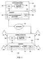
- Figure 1 depicts a system for computing a location of a mobile receiver, in accordance with an embodiment of the present invention
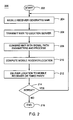
- Figure 2 presents a method for computing a location of a mobile receiver in accordance with an embodiment of the present invention.
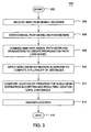
- Figure 3 presents a method for processing a network measurement report to compute a location of a mobile receiver, in accordance with one embodiment of the present invention
- Figure 1 depicts a system comprising a mobile receiver 102 and at least one location server 116.
- the mobile receiver 102 comprises a central processing unit (CPU) 108, support circuits 106, and a memory 110.
- the location server 116 comprises a CPU 120, support circuits 118, and a memory 122.
- the CPU 108, 120 may comprise one or more conventionally available microprocessors.
- the support circuits 106, 118 are well known circuits that comprise power supplies, clocks, input/output interface circuitry, and the like.
- the mobile receiver 102 may include any device that is capable of communicating with a wireless network, such as, for example, a mobile cellular telephone, a handset, a personal digital assistant (PDA), a portable, laptop, notebook, or other computer; a pager, or a telematics device.
- a wireless network such as, for example, a mobile cellular telephone, a handset, a personal digital assistant (PDA), a portable, laptop, notebook, or other computer; a pager, or a telematics device.
- PDA personal digital assistant
- Memory 110, 122 may comprise random access memory, read only memory, removable disk memory, flash memory, and various combinations of these types of memory.
- the memory 110, 122 is sometimes referred to as main memory and may in part be used as cache memory or buffer memory.
- the memory 110, 122 stores various software packages and components, such as an operating system (O/S) 126, 128.
- Figure 1 depicts one location server 116 in system 100, other embodiments of the present invention include systems with multiple location servers.
- Memory 110 of the mobile receiver 102 may comprise a software application 112 with functionality for generating at least one Network Measurement Report (NMR) 114, which may be stored internally in memory 110.
- NMR Network Measurement Report
- the NMR 114 is stored in a database (not shown), external to the mobile receiver 102.
- the NMR is generated from information and data received from the cellular stations 104, via wireless communications.
- the mobile receiver 110 then transmits the NMR 114 to the location server 116 via a communications network 130, preferably a telecommunications network.
- the communications network 130 may be any conventional network, such as an Ethernet network, a fiber channel network, or a wide area network (WAN) that provides either a direct or indirect (e.g., Internet via a wired or wireless connection, or public switched telephone network (PSTN)) connection.
- WAN wide area network
- Memory 122 of the location server 116 comprises a software application 124 for generating location data associated with the mobile receiver 102 using the received NMR 114.
- the location server 116 may then transmit the location data to the mobile receiver 102 through the network 130.
- the location server 116 may transmit the location data to a third party (TP) 132 upon request.
- TP third party
- Figure 2 provides a method for computing the location of a mobile receiver, according to an embodiment of the present invention.
- the steps need not be in the sequence illustrated, and some of the steps may be essentially simultaneous.
- Method 200 begins at step 202 and continues with a mobile receiver, such as mobile cellular phone, generating an NMR based on a plurality of cellular stations, at step 204.
- the NMR may comprise information associated with each cellular station, such as a unique station identifier and a received signal strength indicator (RSSI) associated with each cellular station.
- the NMR may be generated by a software application located in the mobile receiver.
- RSSI received signal strength indicator
- the mobile receiver transmits the NMR to at least one location server over a communications network.
- the location server receives the NMR and combines the NMR with a plurality of signal path modeling parameters associated with the mobile receiver and with the plurality of cellular stations. The location server then processes the NMR to compute a geographical location of the mobile receiver, at step 210.
- the location server delivers the computed location to the mobile receiver for use by a user, or perhaps to some other third party, at step 212.
- the mobile receiver determines whether the method should be repeated, at step 214. The method may be repeated, for example, if the mobile receiver is moving and not stationary, such that periodic location computations would be of use to a moving user. If the method is to be repeated, the method restarts at step 204. If the method is not to be repeated, the process ends at step 216.
- the method 300 starts at step 302 and continues to the location server obtaining an NMR at any given time from a mobile receiver.
- the NMR comprises information regarding a plurality of cellular stations within a certain geographical region of the mobile receiver's location. Such information includes a cellular station identifier and a RSSI for each cellular station.
- a software application maintained by the location server receives the NMR in order to compute the location of the mobile receiver.
- the RSSI is a received signal strength value generated from the power strength of the signal measured between the transmit signal power (P T ) from the mobile receiver to the cellular station, and the return signal power (P R ) to the mobile receiver from the cellular station. Based on the RSSI, a distance between the mobile receiver and the cellular station may be computed and incorporated into computing a location of the mobile receiver.
- the location server obtains other cellular station data, such as, a location for each cellular station, man-made structures and topographical features surrounding the location of each cellular station, a cellular station antenna height, a cellular station antenna direction, an effective radiated power of each cellular station, and a frequency for each cellular station, antenna sector data, antenna gain pattern modeling, relative height-above-ground difference between the mobile receiver and a transmitter located at each cellular station, and antenna beamwidth.
- cellular station data such as, a location for each cellular station, man-made structures and topographical features surrounding the location of each cellular station, a cellular station antenna height, a cellular station antenna direction, an effective radiated power of each cellular station, and a frequency for each cellular station, antenna sector data, antenna gain pattern modeling, relative height-above-ground difference between the mobile receiver and a transmitter located at each cellular station, and antenna beamwidth.
- Such data may be previously provided to the location server by an external source, such as the location of the cellular station, and antenna information associated with the cellular station, while other data, such as the relative height above ground distance between the mobile receiver and the cellular station transmitter, is obtained contemporaneously with the NMR.
- Such data is labeled "signal path modeling parameters," as the location server uses such parameters to map out the signal path between the mobile receiver and a specific cellular station.
- the signal path modeling parameters further comprise parameters associated with an urban path loss model, such as, for example, urban structural features associated with each cellular station.
- the signal path modeling parameters further comprise parameters associated with a path terrain model, such as, for example, terrain data and environmental features surrounding each cellular station.
- the location server application combines the NMR data and the signal path modeling parameters to create a propagation path loss model.
- the path loss model is generated to substantially mimic the signal path traveled between the mobile receiver and a specific cellular station.
- the location server application then applies a non-linear estimation algorithm to the path loss model to compute a distance associated with a specific cellular station in relation to the mobile receiver, at step 310.
- the location server application computes a plurality of distances, wherein each distance is related to each cellular station.
- the location server application applies the Downhill Simplex algorithm to the path loss model to compute a location of the mobile receiver.
- the location server application computes a location of the mobile receiver using the plurality of distances computed in step 310 by iterating the non-linear estimation algorithm and resulting mobile receiver location until converged.
- the non-linear estimation algorithm is employed because the geometry and non-linear characteristics of the range models may cause certain GPS iterative positioning techniques to operate inadequately.
- the receiver position is moved to find the location that minimizes the effects of variances in the ranges derived from the models. Hence, iteration of the non-linear estimation algorithm results in convergence of the ranges.
- the location of the mobile receiver is computed by applying a triangulation algorithm to the plurality of distances if there is an equal number of observations and variables.
- the location server may deliver the computed location to the mobile receiver or an outside third party, via a communications network, such as a wireless telecommunications network.
- a communications network such as a wireless telecommunications network.
- Test examples applying method 300 produced a geographic location for a mobile receiver with an accuracy of about 91 percent within a 150-meter radius of the mobile receiver, and an accuracy of about 100 percent within a 300-meter radius of the mobile receiver.
- the method further comprises obtaining multiple NMRs, including multiple RSSIs associated with a group of cellular stations over a period of time, to provide information for computing the location of a mobile receiver as it is continuously moving, for example, if a user is driving and desires to obtain his/her location using his/her mobile cellular phone.
- Another embodiment of the present invention provides a method for computing a location of a mobile receiver further comprising the step of obtaining geographical location data from a global positioning system (GPS) associated with the mobile receiver, and combining the GPS position data with the computed plurality of distances to produce an improved location for the mobile receiver.
- GPS global positioning system
- Another embodiment of the present invention provides a method for computing a location of a mobile receiver further comprising repeating the application of the non-linear estimation algorithm to a set of signal path modeling parameters, discarding at least one outlier computed distance, and computing a location of the mobile receiver without the at least one outlier distance to produce an improved location.
Landscapes
- Engineering & Computer Science (AREA)
- Physics & Mathematics (AREA)
- General Physics & Mathematics (AREA)
- Radar, Positioning & Navigation (AREA)
- Remote Sensing (AREA)
- Computer Networks & Wireless Communication (AREA)
- Signal Processing (AREA)
- Mobile Radio Communication Systems (AREA)
- Telephone Function (AREA)
- Telephonic Communication Services (AREA)
- Position Fixing By Use Of Radio Waves (AREA)
Abstract
Description
- The present invention generally relates to mobile cellular receivers and, more particularly, to a method and system for computing a geographical location of the mobile receiver using at least one network measurement report.
- A number of different types of location-based service applications have been developed or proposed for wireless telecommunications networks, i.e., communications networks involving at least one wireless interface between communicating devices. Generally, such applications determine or otherwise obtain location information regarding the location of a mobile receiver under consideration, e.g., a wireless telephone, PDA, wireless data terminal or the like, and provide service information based on the mobile receiver location. Examples of location-based service applications include E911, local service information and location-based billing applications. In E911 applications, emergency calls are routed to a selected dispatcher based on the location of origin of an emergency call. Additionally, location information may be transmitted to the dispatcher or another location to assist in the emergency response. Location-based service applications provide information regarding local services such as hotels or restaurants based on a request entered via a mobile receiver. In location-based billing applications, a rate for a call placed or received by a wireless telephone is dependent on the location of the phone, e.g., whether the phone is inside or outside of a "home zone" for the subscriber proximate to the subscriber's residence, business or other defined location. Various other applications have been proposed or implemented.
- Location-based service applications generally involve comparing a current (or recent) location to a location of interest, e.g., a point identified by geographical coordinates, a boundary, or a predefined service zone definition, to make a binary determination (e.g., that the mobile receiver is either inside or outside of a zone under consideration), a matching determination (e.g., that the mobile receiver location matches or overlaps one or more stored zone definitions), or a proximity determination (e.g., to identify the closest service provider(s)). In any case, at one or more relevant processing steps, mobile receiver location information corresponding to a particular time is compared to service location information corresponding to one or more service zones, service provider locations or other stored location information. Thus, in E911 applications the mobile receiver location at the time of placing an E911 call may be compared to the dispatcher coverage zones of an emergency response network. In local service information applications, the location of a mobile receiver at the time of submitting, for example, a local hotel information request, may be compared to a database of hotel location information. The location of a mobile receiver during a call may be used by a location-based billing application to establish billing parameters for the call.
- In addition, location-based service applications generally provide service information in response to an input by a subscriber or other application user invoking the application. In the case of local service information applications, the input is generally an explicit service request entered via the mobile receiver. In E911 or location-based billing applications, the location-based service application may be invoked invisibly, from the perspective of the mobile receiver, upon making a call. In other cases, the input invoking the application to provide service information based on the location of the mobile receiver is received from a separate application. In such applications, the service information is nonetheless provided in response to an input requesting location-based services. That is, the trigger event generally is, from the perspective of the service application, a service request.
- In some cases today, multiple sources of location information are available. For example, within certain areas of existing networks, a network-based Location Determination Technology (LDT), such as, for example, Position Determination Equipment (PDE) or a Serving Mobile Location Center (SMLC), is available to locate mobile receivers. Such network-based equipment often utilize a multilateration technology, such as time difference of arrival of a signal from the mobile receiver or an angle of arrival to locate a unit based on signals transmitted between the mobile receiver and multiple equipment sites having known locations, such as cell stations. Some mobile receivers are equipped with Global Positioning System (GPS) receivers that can determine the position of the unit based on signals from satellites of the GPS constellation. However, the accuracy of the GPS location determination can degrade in urban areas, that is, areas with multiple buildings and structures that interfere with the signal path between the GPS satellites and the mobile receiver.
- Alternately, location information may be available from the network itself, e.g., information that is used to route calls, manage cell-to-cell handoff or otherwise operate the network. For example, such information may include a cell station, cell sector or other network subdivision identifier ("Cell ID") or handoff information residing in the network for the purposes of handoff management such as Network Measurement Report (NMR) and Mobile Assisted Hand-Off (MAHO) information. Specifically, the NMR is generated by software in the mobile receiver from data collected by the receiver measuring signals received from a base cell station and neighboring cell stations to generate a Received Signal Strength Indicator (RSSI) for each station. Each RSSI is coupled to the Cell ID for each station to create the NMR, which is transmitted to the network using the measurement reporting scheme specified in the system. Based on the NMR, the network can determine the location of a specific mobile receiver. However, the accuracy of the NMR-based location can be limited.
- Therefore, there is a need in the art for a method and system for determining the location of a mobile receiver with increased accuracy.
- Embodiments of the present invention comprise a method and apparatus for determining a location of a mobile receiver. In one embodiment, a plurality of signal strengths received by a mobile receiver is measured, wherein the plurality of signal strengths are associated with a plurality of cellular stations, wherein the plurality of signal strengths is associated with a specific point in time. The plurality of signal strengths is combined with a plurality of signal path modeling parameters to create a propagation path loss model of the path between the plurality of cellular stations and the mobile receiver. A non-linear estimation algorithm is applied to the propagation path loss model. A plurality of distances is generated, wherein each distance is associated with the mobile receiver and each of the plurality of cellular stations. The location of the mobile receiver is computed by iterating the non-linear estimation algorithm and resulting mobile receiver position until converged. The locations of the mobile receiver may be provided to a location server via a telecommunications network.
According to an aspect, a method for determining a location of a mobile receiver is provided, the method comprising: - measuring a plurality of signal strengths received by a mobile receiver, wherein the plurality of signal strengths are associated with a plurality of cellular stations, wherein the plurality of signal strengths is associated with a specific point in time;
- combining the plurality of signal strengths with a plurality of signal path modeling parameters to create a propagation path loss model of the path between the plurality of cellular stations and the mobile receiver;
- applying a non-linear estimation algorithm to the propagation path loss model;
- generating a plurality of distances, wherein each distance is associated with the mobile receiver and each of the plurality of cellular stations; and
- computing the location of the mobile receiver by iterating the non-linear estimation algorithm and resulting mobile receiver position until converged.
- performing the multiple applications of the non-linear estimation algorithm;
- discarding at least one outlier computed distance; and
- computing a third improved geographical location of the mobile receiver.
- obtaining a network measurement report, wherein the network measurement report comprises a plurality of signal strengths associated associated with a plurality of cellular stations;
- combining the network measurement report with a plurality of signal path modeling parameters to create an urban path loss model;
- applying a Downhill Simplex algorithm to the urban path loss model;
- generating a plurality of distances, wherein each distance is associated with the mobile receiver and each of the plurality of cellular stations; and
- computing the location of the mobile receiver.
- a plurality of cellular stations;
- a mobile receiver for determining a plurality of signal strengths associated with the plurality of cellular stations, wherein the plurality of signal strengths are associated with a specific point in time; and
- a location server for computing a plurality of signal path modeling parameters related to the mobile receiver combining the plurality of signal strengths with the plurality of signal path modeling parameters to create a propagation path loss model, applying a non-linear estimation algorithm to the propagation path loss model, generating a plurality of distances, wherein each distance is associated with the mobile receiver and each of the plurality of cellular stations; and computing the location of the mobile receiver by iterating the non-linear algorithm and the location computation; and
- a network for communications between the mobile receiver and the location server.
- So that the manner in which the above recited features of the present invention can be understood in detail, a more particular description of the invention, briefly summarized above, may be had by reference to embodiments, some of which are illustrated in the appended drawings. It is to be noted, however, that the appended drawings illustrate only typical embodiments of this invention and are therefore not to be considered limiting of its scope, for the invention may admit to other equally effective embodiments.
-
Figure 1 depicts a system for computing a location of a mobile receiver, in accordance with an embodiment of the present invention; -
Figure 2 presents a method for computing a location of a mobile receiver in accordance with an embodiment of the present invention; and -
Figure 3 presents a method for processing a network measurement report to compute a location of a mobile receiver, in accordance with one embodiment of the present invention; -
Figure 1 depicts a system comprising amobile receiver 102 and at least onelocation server 116. Themobile receiver 102 comprises a central processing unit (CPU) 108,support circuits 106, and amemory 110. Thelocation server 116 comprises aCPU 120,support circuits 118, and amemory 122. TheCPU support circuits mobile receiver 102 may include any device that is capable of communicating with a wireless network, such as, for example, a mobile cellular telephone, a handset, a personal digital assistant (PDA), a portable, laptop, notebook, or other computer; a pager, or a telematics device. -
Memory memory memory Figure 1 depicts onelocation server 116 insystem 100, other embodiments of the present invention include systems with multiple location servers. -
Memory 110 of themobile receiver 102 may comprise asoftware application 112 with functionality for generating at least one Network Measurement Report (NMR) 114, which may be stored internally inmemory 110. In an alternate embodiment, theNMR 114 is stored in a database (not shown), external to themobile receiver 102. The NMR is generated from information and data received from thecellular stations 104, via wireless communications. - The
mobile receiver 110 then transmits theNMR 114 to thelocation server 116 via acommunications network 130, preferably a telecommunications network. Alternately, thecommunications network 130 may be any conventional network, such as an Ethernet network, a fiber channel network, or a wide area network (WAN) that provides either a direct or indirect (e.g., Internet via a wired or wireless connection, or public switched telephone network (PSTN)) connection. -
Memory 122 of thelocation server 116 comprises asoftware application 124 for generating location data associated with themobile receiver 102 using the receivedNMR 114. Thelocation server 116 may then transmit the location data to themobile receiver 102 through thenetwork 130. In another embodiment of the present invention, thelocation server 116 may transmit the location data to a third party (TP) 132 upon request. -
Figure 2 provides a method for computing the location of a mobile receiver, according to an embodiment of the present invention. The steps need not be in the sequence illustrated, and some of the steps may be essentially simultaneous.Method 200 begins atstep 202 and continues with a mobile receiver, such as mobile cellular phone, generating an NMR based on a plurality of cellular stations, atstep 204. The NMR may comprise information associated with each cellular station, such as a unique station identifier and a received signal strength indicator (RSSI) associated with each cellular station. The NMR may be generated by a software application located in the mobile receiver. - At
step 206, the mobile receiver transmits the NMR to at least one location server over a communications network. Atstep 208, the location server receives the NMR and combines the NMR with a plurality of signal path modeling parameters associated with the mobile receiver and with the plurality of cellular stations. The location server then processes the NMR to compute a geographical location of the mobile receiver, atstep 210. - The location server delivers the computed location to the mobile receiver for use by a user, or perhaps to some other third party, at
step 212. The mobile receiver then determines whether the method should be repeated, atstep 214. The method may be repeated, for example, if the mobile receiver is moving and not stationary, such that periodic location computations would be of use to a moving user. If the method is to be repeated, the method restarts atstep 204. If the method is not to be repeated, the process ends atstep 216. - In
Figure 3 , the processing of a NMR to compute a location of a mobile receiver is described further. Themethod 300 starts atstep 302 and continues to the location server obtaining an NMR at any given time from a mobile receiver. As previously stated, the NMR comprises information regarding a plurality of cellular stations within a certain geographical region of the mobile receiver's location. Such information includes a cellular station identifier and a RSSI for each cellular station. A software application maintained by the location server receives the NMR in order to compute the location of the mobile receiver. The RSSI is a received signal strength value generated from the power strength of the signal measured between the transmit signal power (PT) from the mobile receiver to the cellular station, and the return signal power (PR) to the mobile receiver from the cellular station. Based on the RSSI, a distance between the mobile receiver and the cellular station may be computed and incorporated into computing a location of the mobile receiver. - However, to compute an accurate location and to take into account environmental conditions of the mobile receiver's location, such as, for example, topographical features, urban features, such as man-made structures and city layouts, etc., at
step 306, the location server obtains other cellular station data, such as, a location for each cellular station, man-made structures and topographical features surrounding the location of each cellular station, a cellular station antenna height, a cellular station antenna direction, an effective radiated power of each cellular station, and a frequency for each cellular station, antenna sector data, antenna gain pattern modeling, relative height-above-ground difference between the mobile receiver and a transmitter located at each cellular station, and antenna beamwidth. Such data may be previously provided to the location server by an external source, such as the location of the cellular station, and antenna information associated with the cellular station, while other data, such as the relative height above ground distance between the mobile receiver and the cellular station transmitter, is obtained contemporaneously with the NMR. Such data is labeled "signal path modeling parameters," as the location server uses such parameters to map out the signal path between the mobile receiver and a specific cellular station. In one embodiment of the present invention, the signal path modeling parameters further comprise parameters associated with an urban path loss model, such as, for example, urban structural features associated with each cellular station. In another embodiment, the signal path modeling parameters further comprise parameters associated with a path terrain model, such as, for example, terrain data and environmental features surrounding each cellular station. - At
step 308, the location server application combines the NMR data and the signal path modeling parameters to create a propagation path loss model. The path loss model is generated to substantially mimic the signal path traveled between the mobile receiver and a specific cellular station. - The location server application then applies a non-linear estimation algorithm to the path loss model to compute a distance associated with a specific cellular station in relation to the mobile receiver, at
step 310. As information associated with multiple cellular stations is included in the NMR, the location server application computes a plurality of distances, wherein each distance is related to each cellular station. In an embodiment of the present invention, the location server application applies the Downhill Simplex algorithm to the path loss model to compute a location of the mobile receiver. - At
step 312, the location server application computes a location of the mobile receiver using the plurality of distances computed instep 310 by iterating the non-linear estimation algorithm and resulting mobile receiver location until converged. The non-linear estimation algorithm is employed because the geometry and non-linear characteristics of the range models may cause certain GPS iterative positioning techniques to operate inadequately. During the application of the non-linear estimation algorithm, the receiver position is moved to find the location that minimizes the effects of variances in the ranges derived from the models. Hence, iteration of the non-linear estimation algorithm results in convergence of the ranges. In one embodiment of the present invention, the location of the mobile receiver is computed by applying a triangulation algorithm to the plurality of distances if there is an equal number of observations and variables. - At
step 314, the location server may deliver the computed location to the mobile receiver or an outside third party, via a communications network, such as a wireless telecommunications network. The method then ends atstep 316. Testexamples applying method 300 produced a geographic location for a mobile receiver with an accuracy of about 91 percent within a 150-meter radius of the mobile receiver, and an accuracy of about 100 percent within a 300-meter radius of the mobile receiver. - In yet another embodiment of the present invention, the method further comprises obtaining multiple NMRs, including multiple RSSIs associated with a group of cellular stations over a period of time, to provide information for computing the location of a mobile receiver as it is continuously moving, for example, if a user is driving and desires to obtain his/her location using his/her mobile cellular phone.
- Another embodiment of the present invention provides a method for computing a location of a mobile receiver further comprising the step of obtaining geographical location data from a global positioning system (GPS) associated with the mobile receiver, and combining the GPS position data with the computed plurality of distances to produce an improved location for the mobile receiver.
- Another embodiment of the present invention provides a method for computing a location of a mobile receiver further comprising repeating the application of the non-linear estimation algorithm to a set of signal path modeling parameters, discarding at least one outlier computed distance, and computing a location of the mobile receiver without the at least one outlier distance to produce an improved location.
- While the foregoing is directed to embodiments of the present invention, other and further embodiments of the invention may be devised without departing from the basic scope thereof, and the scope thereof is determined by the claims that follow.
Advantageously, the non-linear estimation algorithm is a Downhill Simplex algorithm.
Advantageously, the step of computing the location further comprises applying a triangulation algorithm to the plurality of distances between the mobile receiver and each of the plurality of cellular stations.
Advantageously, the mobile receiver is a mobile cellular phone.
Advantageously, the method further comprises obtaining the plurality of signal strengths and the plurality of cellular station identifiers from a network measurement report.
Advantageously, the method further comprises obtaining the network measurement report from the mobile receiver.
Advantageously, the method further comprises receiving the network measurement report through a communications network.
Advantageously, the method further comprises obtaining multiple pluralities of signal strengths over a period of time.
Advantageously, the method further comprises computing a first improved geographical position.
Advantageously, the method further comprises obtaining geographical location data from a global positioning system, wherein the geographical location data is associated with the mobile receiver and a plurality of global positioning satellites.
Advantageously, the method further comprises combining the geographical location data with the computed geographical location to produce a second improved geographical location.
Advantageously, the method further comprises transmitting the location to the mobile receiver.
Advantageously, the method further comprises transmitting the location to a third party.
Advantageously, the method further comprises:
Advantageously, the first software application combines the plurality of signal strengths and the plurality of cellular station identifiers to create a network measurement report.
Advantageously, the network is a wireless telecommunications network.
Advantageously, the mobile device comprises a global positioning system component capable of providing location information for the mobile device.
Claims (10)
- A method for determining a location of a mobile receiver, the method comprising:measuring a plurality of signal strengths received by a mobile receiver, wherein the plurality of signal strengths are associated with a plurality of cellular stations, wherein the plurality of signal strengths is associated with a specific point in time;combining the plurality of signal strengths with a plurality of signal path modeling parameters to create a propagation path loss model of the path between the plurality of cellular stations and the mobile receiver;applying a non-linear estimation algorithm to the propagation path loss model;generating a plurality of distances, wherein each distance is associated with the mobile receiver and each of the plurality of cellular stations; andcomputing the location of the mobile receiver by iterating the non-linear estimation algorithm and resulting mobile receiver position until converged.
- The method of Claim 1, wherein the plurality of signal path modeling parameters comprises at least a location for each cellular station, a cellular station antenna height, a cellular station antenna direction, an effective radiated power of each cellular station, and a frequency for each cellular station, antenna sector data, antenna gain pattern modeling, relative height-above-ground difference between the mobile receiver and a transmitter located at each cellular station, urban path loss parameters, path terrain model parameters including terrain data and environmental features associated with each cellular station, urban structural features associated with each cellular station, and antenna beamwidth.
- The method of Claim 1, wherein the non-linear estimation algorithm is a Downhill Simplex algorithm.
- The method of Claim 1, wherein the step of computing the location further comprises applying a triangulation algorithm to the plurality of distances between the mobile receiver and each of the plurality of cellular stations.
- The method of Claim 1, wherein the mobile receiver is a mobile cellular phone.
- A method for determining a location of a mobile receiver, the method comprising:obtaining a network measurement report, wherein the network measurement report comprises a plurality of signal strengths associated associated with a plurality of cellular stations;combining the network measurement report with a plurality of signal path modeling parameters to create an urban path loss model;applying a Downhill Simplex algorithm to the urban path loss model;generating a plurality of distances, wherein each distance is associated with the mobile receiver and each of the plurality of cellular stations; andcomputing the location of the mobile receiver.
- A system for determining a location of a mobile receiver, the system comprising:a plurality of cellular stations;a mobile receiver for determining a plurality of signal strengths associated with the plurality of cellular stations, wherein the plurality of signal strengths are associated with a specific point in time; anda location server for computing a plurality of signal path modeling parameters related to the mobile receiver combining the plurality of signal strengths with the plurality of signal path modeling parameters to create a propagation path loss model, applying a non-linear estimation algorithm to the propagation path loss model, generating a plurality of distances, wherein each distance is associated with the mobile receiver and each of the plurality of cellular stations; and computing the location of the mobile receiver by iterating the non-linear algorithm and the location computation; anda network for communications between the mobile receiver and the location server.
- The system of Claim 7, wherein the mobile receiver is a mobile cellular phone.
- The system of Claim 7, wherein the first software application combines the plurality of signal strengths and the plurality of cellular station identifiers to create a network measurement report.
- The system of Claim 7, wherein the network is a wireless telecommunications network.
Applications Claiming Priority (1)
| Application Number | Priority Date | Filing Date | Title |
|---|---|---|---|
| US11/865,414 US20090088180A1 (en) | 2007-10-01 | 2007-10-01 | Computing geographical location of a mobile receiver using network measurement reports |
Publications (2)
| Publication Number | Publication Date |
|---|---|
| EP2045613A1 true EP2045613A1 (en) | 2009-04-08 |
| EP2045613B1 EP2045613B1 (en) | 2011-11-09 |
Family
ID=40149869
Family Applications (1)
| Application Number | Title | Priority Date | Filing Date |
|---|---|---|---|
| EP08016793A Ceased EP2045613B1 (en) | 2007-10-01 | 2008-09-24 | Computing geographical location of a mobile receiver using network measurement reports |
Country Status (5)
| Country | Link |
|---|---|
| US (1) | US20090088180A1 (en) |
| EP (1) | EP2045613B1 (en) |
| KR (1) | KR20090033819A (en) |
| CN (1) | CN101516135A (en) |
| TW (1) | TW200938869A (en) |
Cited By (8)
| Publication number | Priority date | Publication date | Assignee | Title |
|---|---|---|---|---|
| EP2323325A1 (en) * | 2009-10-30 | 2011-05-18 | Research In Motion Limited | Method and system for receiver adaptation based on knowledge of wireless propagation environments |
| WO2012178016A1 (en) * | 2011-06-22 | 2012-12-27 | Qualcomm Incorporated | Wireless device positioning in multicarrier configurations |
| US8660540B2 (en) | 2009-04-21 | 2014-02-25 | Qualcomm Incorporated | Supporting version negotiation for positioning for terminals in a wireless network |
| US8660574B2 (en) | 2008-04-02 | 2014-02-25 | Qualcomm Incorporated | Generic positioning protocol |
| GB2508935A (en) * | 2012-12-12 | 2014-06-18 | Ahmad Al-Najjar | Location using a ubiquitous multi-environment high dynamic indication (U-MEHDI) technique |
| US9435874B2 (en) | 2009-04-21 | 2016-09-06 | Qualcomm Incorporated | Method and apparatus for supporting positioning for terminals in a wireless network |
| FR3072796A1 (en) * | 2017-10-25 | 2019-04-26 | Orange | METHOD FOR GEOLOCATING CONNECTED OBJECTS, CONNECTED OBJECT, TERMINAL AND SYSTEM THEREFOR. |
| US11059503B2 (en) | 2019-11-26 | 2021-07-13 | Willowglen Systems Inc. | Systems and methods for rail worker and rail vehicle warning and position determination |
Families Citing this family (33)
| Publication number | Priority date | Publication date | Assignee | Title |
|---|---|---|---|---|
| US8616967B2 (en) | 2004-02-25 | 2013-12-31 | Cfph, Llc | System and method for convenience gaming |
| US7534169B2 (en) | 2005-07-08 | 2009-05-19 | Cfph, Llc | System and method for wireless gaming system with user profiles |
| US10510214B2 (en) | 2005-07-08 | 2019-12-17 | Cfph, Llc | System and method for peer-to-peer wireless gaming |
| US9306952B2 (en) | 2006-10-26 | 2016-04-05 | Cfph, Llc | System and method for wireless gaming with location determination |
| US9411944B2 (en) | 2006-11-15 | 2016-08-09 | Cfph, Llc | Biometric access sensitivity |
| US9183693B2 (en) | 2007-03-08 | 2015-11-10 | Cfph, Llc | Game access device |
| JP5185390B2 (en) * | 2007-10-20 | 2013-04-17 | エアビクティ インコーポレイテッド | Wireless in-band signaling method and system using in-vehicle system |
| US8594138B2 (en) | 2008-09-15 | 2013-11-26 | Airbiquity Inc. | Methods for in-band signaling through enhanced variable-rate codecs |
| US8073440B2 (en) | 2009-04-27 | 2011-12-06 | Airbiquity, Inc. | Automatic gain control in a personal navigation device |
| US8233896B2 (en) * | 2009-06-22 | 2012-07-31 | Northrop Grumman Systems Corporation | Mobile communication units that display connectivity loss boundaries |
| US8418039B2 (en) * | 2009-08-03 | 2013-04-09 | Airbiquity Inc. | Efficient error correction scheme for data transmission in a wireless in-band signaling system |
| US8249865B2 (en) * | 2009-11-23 | 2012-08-21 | Airbiquity Inc. | Adaptive data transmission for a digital in-band modem operating over a voice channel |
| US8956231B2 (en) | 2010-08-13 | 2015-02-17 | Cfph, Llc | Multi-process communication regarding gaming information |
| US20220296999A1 (en) | 2010-08-13 | 2022-09-22 | Cfph, Llc | Multi-process communication regarding gaming information |
| US10621247B2 (en) * | 2011-03-03 | 2020-04-14 | Cox Communications, Inc. | Location and profile based system and service |
| TW201300813A (en) * | 2011-06-22 | 2013-01-01 | Ind Tech Res Inst | Electronic device, positioning method, positioning system, computer program product and recording medium |
| US9761083B2 (en) | 2011-09-16 | 2017-09-12 | Elottery, Inc. | Location, age and identity verification for mobile gaming |
| US8834251B2 (en) | 2011-09-16 | 2014-09-16 | Elottery, Inc. | Location and age verification for mobile lottery play |
| US8848825B2 (en) | 2011-09-22 | 2014-09-30 | Airbiquity Inc. | Echo cancellation in wireless inband signaling modem |
| US9071936B2 (en) * | 2012-01-31 | 2015-06-30 | Qualcomm Incorporated | Methods and devices for facilitating location approximation in a CDMA 1x network |
| TW201838697A (en) | 2012-02-28 | 2018-11-01 | 美商Cfph有限責任公司 | Method and device for providing game service |
| US9578115B2 (en) | 2012-06-15 | 2017-02-21 | Qualcomm Incorporated | Indoor location server provision and discovery |
| US11265673B2 (en) | 2012-06-15 | 2022-03-01 | Qualcomm Incorporated | Client access to mobile location services |
| US10419890B2 (en) | 2012-06-15 | 2019-09-17 | Qualcomm Incorporated | Client access to mobile location services |
| KR101895455B1 (en) * | 2012-06-19 | 2018-10-04 | 삼성전자주식회사 | Method and apparatus for providing semantic location in electronic device |
| US8971866B2 (en) | 2012-08-14 | 2015-03-03 | International Business Machines Corporation | Automatically connecting to a best available calling device based on resource strength |
| WO2015184431A1 (en) * | 2014-05-30 | 2015-12-03 | Vioozer Inc. | System and process for location-based informationretrieval |
| TWI618423B (en) * | 2015-05-15 | 2018-03-11 | 財團法人資訊工業策進會 | User equipment, mobile hotspot equipment, backhaul device and method for establishing a path loss model database |
| CN106028354B (en) * | 2016-05-13 | 2019-06-11 | 广州杰赛科技股份有限公司 | Evaluation method and evaluation device for signal detection function of mobile terminal |
| US10551504B2 (en) * | 2016-10-04 | 2020-02-04 | Trimble Inc. | Method and system for sharing convergence data |
| US10805452B2 (en) * | 2019-01-13 | 2020-10-13 | Nextnav, Llc | Systems and methods for determining a height of a mobile device above a surface |
| US11277180B1 (en) * | 2020-11-11 | 2022-03-15 | Qualcomm Incorporated | Apparatus and method for low overhead frequency-averaged beam pattern feedback in millimeter wave positioning systems |
| US11683090B1 (en) | 2022-01-18 | 2023-06-20 | T-Mobile Usa, Inc. | Laser-based enhancement of signal propagation path for mobile communications |
Citations (3)
| Publication number | Priority date | Publication date | Assignee | Title |
|---|---|---|---|---|
| US20030098811A1 (en) | 2001-11-27 | 2003-05-29 | Alcatel | Method of determining the position of a mobile station on the basis of propagation models |
| US20040259575A1 (en) * | 1998-09-22 | 2004-12-23 | Polaris Wireless, Inc. | Location determination using RF fingerprints |
| US20050285793A1 (en) | 2004-06-23 | 2005-12-29 | Sugar Gary L | Self-calibrated path loss position estimation and zone of impact determination |
Family Cites Families (3)
| Publication number | Priority date | Publication date | Assignee | Title |
|---|---|---|---|---|
| US7689240B2 (en) * | 2005-11-16 | 2010-03-30 | Trueposition, Inc. | Transmit-power control for wireless mobile services |
| WO2007124300A2 (en) * | 2006-04-21 | 2007-11-01 | Sensis Corporation | A system and method for multilaterating a position of a target using mobile remote receiving units |
| US8140092B2 (en) * | 2007-04-18 | 2012-03-20 | Trueposition, Inc. | Sparsed U-TDOA wireless location networks |
-
2007
- 2007-10-01 US US11/865,414 patent/US20090088180A1/en not_active Abandoned
-
2008
- 2008-09-24 EP EP08016793A patent/EP2045613B1/en not_active Ceased
- 2008-09-30 TW TW097137526A patent/TW200938869A/en unknown
- 2008-10-01 KR KR1020080096681A patent/KR20090033819A/en not_active Ceased
- 2008-10-06 CN CNA2008101693083A patent/CN101516135A/en active Pending
Patent Citations (3)
| Publication number | Priority date | Publication date | Assignee | Title |
|---|---|---|---|---|
| US20040259575A1 (en) * | 1998-09-22 | 2004-12-23 | Polaris Wireless, Inc. | Location determination using RF fingerprints |
| US20030098811A1 (en) | 2001-11-27 | 2003-05-29 | Alcatel | Method of determining the position of a mobile station on the basis of propagation models |
| US20050285793A1 (en) | 2004-06-23 | 2005-12-29 | Sugar Gary L | Self-calibrated path loss position estimation and zone of impact determination |
Non-Patent Citations (1)
| Title |
|---|
| BARTON R R ET AL: "Modifications of the Nelder-Mead simplex method for stochastic simulation response optimization", SIMULATION CONFERENCE, 1991. PROCEEDINGS., WINTER PHOENIX, AZ, USA 8-11 DEC. 1991, NEW YORK, NY, USA,IEEE, US, 8 December 1991 (1991-12-08), pages 945 - 953, XP010052816, ISBN: 978-0-7803-0181-8 * |
Cited By (20)
| Publication number | Priority date | Publication date | Assignee | Title |
|---|---|---|---|---|
| US8660574B2 (en) | 2008-04-02 | 2014-02-25 | Qualcomm Incorporated | Generic positioning protocol |
| US9832612B2 (en) | 2008-04-02 | 2017-11-28 | Qualcomm Incorporated | Generic positioning protocol |
| US9386408B2 (en) | 2008-04-02 | 2016-07-05 | Qualcomm Incorporated | Generic positioning protocol |
| US10834696B2 (en) | 2009-04-21 | 2020-11-10 | Qualcomm Incorporated | Method and apparatus for supporting positioning for terminals in a wireless network |
| US10149275B2 (en) | 2009-04-21 | 2018-12-04 | Qualcomm Incorporated | Method and apparatus for supporting positioning for terminals in a wireless network |
| US11419090B2 (en) | 2009-04-21 | 2022-08-16 | Qualcomm Incorporated | Method and apparatus for supporting positioning for terminals in a wireless network |
| US8660540B2 (en) | 2009-04-21 | 2014-02-25 | Qualcomm Incorporated | Supporting version negotiation for positioning for terminals in a wireless network |
| US9398442B2 (en) | 2009-04-21 | 2016-07-19 | Qualcomm Incorporated | Supporting version negotiation for positioning for terminals in a wireless network |
| US9435874B2 (en) | 2009-04-21 | 2016-09-06 | Qualcomm Incorporated | Method and apparatus for supporting positioning for terminals in a wireless network |
| US10863475B2 (en) | 2009-04-21 | 2020-12-08 | Qualcomm Incorporated | Method and apparatus for supporting positioning for terminals in a wireless network |
| US9867161B2 (en) | 2009-04-21 | 2018-01-09 | Qualcomm Incorporated | Method and apparatus for supporting positioning for terminals in a wireless network |
| EP2323325A1 (en) * | 2009-10-30 | 2011-05-18 | Research In Motion Limited | Method and system for receiver adaptation based on knowledge of wireless propagation environments |
| WO2012178016A1 (en) * | 2011-06-22 | 2012-12-27 | Qualcomm Incorporated | Wireless device positioning in multicarrier configurations |
| US9363782B2 (en) | 2011-06-22 | 2016-06-07 | Qualcomm Incorporated | Methods and apparatus for wireless device positioning in multicarrier configurations |
| GB2508935A (en) * | 2012-12-12 | 2014-06-18 | Ahmad Al-Najjar | Location using a ubiquitous multi-environment high dynamic indication (U-MEHDI) technique |
| US9451404B2 (en) | 2012-12-12 | 2016-09-20 | Ahmad AL-NAJJAR | System and method for determining a position of a mobile unit |
| FR3072796A1 (en) * | 2017-10-25 | 2019-04-26 | Orange | METHOD FOR GEOLOCATING CONNECTED OBJECTS, CONNECTED OBJECT, TERMINAL AND SYSTEM THEREFOR. |
| WO2019081847A1 (en) * | 2017-10-25 | 2019-05-02 | Orange | Method for geolocation of connected objects, connected object, associated terminal and system |
| US11310627B2 (en) | 2017-10-25 | 2022-04-19 | Orange | Method for geolocation of connected objects, connected object, associated terminal and system |
| US11059503B2 (en) | 2019-11-26 | 2021-07-13 | Willowglen Systems Inc. | Systems and methods for rail worker and rail vehicle warning and position determination |
Also Published As
| Publication number | Publication date |
|---|---|
| EP2045613B1 (en) | 2011-11-09 |
| CN101516135A (en) | 2009-08-26 |
| TW200938869A (en) | 2009-09-16 |
| US20090088180A1 (en) | 2009-04-02 |
| KR20090033819A (en) | 2009-04-06 |
Similar Documents
| Publication | Publication Date | Title |
|---|---|---|
| EP2045613B1 (en) | Computing geographical location of a mobile receiver using network measurement reports | |
| EP3293539B1 (en) | Use of mobile stations for determination of base station location parameters in a wireless mobile communication system | |
| US8289210B2 (en) | Location measurement acquisition adaptive optimization | |
| US8996031B2 (en) | Location estimation of a mobile device in a UMTS network | |
| JP6100306B2 (en) | WLAN and other wireless network location methods | |
| US9237415B2 (en) | Method and system for estimating range of mobile device to wireless installation | |
| LaMarca et al. | Place lab: Device positioning using radio beacons in the wild | |
| KR100583010B1 (en) | How to determine the location of the GPS receiver using the estimated reference time | |
| US7383049B2 (en) | Automation of maintenance and improvement of location service parameters in a data base of a wireless mobile communication system | |
| US9137772B2 (en) | System and method for mass calibration of radio frequency fingerprint (RF-FP) location measurements | |
| US20100093377A1 (en) | Creating And Using Base Station Almanac Information In A Wireless Communication System Having A Position Location Capability | |
| US20100117898A1 (en) | Determining positioning of wireless terminal in telecommunications network | |
| KR20080057222A (en) | How to find the physical location of a mobile phone at a given time | |
| CN101336556B (en) | Method and device for high-accuracy positioning reference measurement of indoor position | |
| WO2003058986A2 (en) | Creating and using base station almanac information in a wireless communication system having a position location capability | |
| US8188920B2 (en) | Location measurement acquisition optimization with Monte Carlo simulation | |
| US20100208649A1 (en) | Method for positioning user equipment accessing multiple mobile networks | |
| KR20120013495A (en) | Positioning system, positioning device and positioning method thereof | |
| KR20120102277A (en) | Positioning method using the phase shift of base station | |
| US9161162B2 (en) | Estimating the geographical position of an apparatus based on its proximity to other apparatuses | |
| Liu et al. | Wireless location uses geometrical transformation method with single propagation delay: Model and detection performance | |
| HK1137609A (en) | Method and system for determining position of a mobile receiver | |
| Reddy et al. | Two base station method for finding location of mobile vehicles based on Doppler shifted signals |
Legal Events
| Date | Code | Title | Description |
|---|---|---|---|
| PUAI | Public reference made under article 153(3) epc to a published international application that has entered the european phase |
Free format text: ORIGINAL CODE: 0009012 |
|
| AK | Designated contracting states |
Kind code of ref document: A1 Designated state(s): AT BE BG CH CY CZ DE DK EE ES FI FR GB GR HR HU IE IS IT LI LT LU LV MC MT NL NO PL PT RO SE SI SK TR |
|
| AX | Request for extension of the european patent |
Extension state: AL BA MK RS |
|
| RIN1 | Information on inventor provided before grant (corrected) |
Inventor name: LUNDGREN, DAVID Inventor name: LAMANCE, JAMES |
|
| 17P | Request for examination filed |
Effective date: 20091008 |
|
| 17Q | First examination report despatched |
Effective date: 20091103 |
|
| AKX | Designation fees paid |
Designated state(s): DE GB |
|
| GRAP | Despatch of communication of intention to grant a patent |
Free format text: ORIGINAL CODE: EPIDOSNIGR1 |
|
| GRAS | Grant fee paid |
Free format text: ORIGINAL CODE: EPIDOSNIGR3 |
|
| GRAA | (expected) grant |
Free format text: ORIGINAL CODE: 0009210 |
|
| AK | Designated contracting states |
Kind code of ref document: B1 Designated state(s): DE GB |
|
| REG | Reference to a national code |
Ref country code: GB Ref legal event code: FG4D |
|
| REG | Reference to a national code |
Ref country code: DE Ref legal event code: R096 Ref document number: 602008011195 Country of ref document: DE Effective date: 20120119 |
|
| PLBE | No opposition filed within time limit |
Free format text: ORIGINAL CODE: 0009261 |
|
| STAA | Information on the status of an ep patent application or granted ep patent |
Free format text: STATUS: NO OPPOSITION FILED WITHIN TIME LIMIT |
|
| 26N | No opposition filed |
Effective date: 20120810 |
|
| REG | Reference to a national code |
Ref country code: DE Ref legal event code: R097 Ref document number: 602008011195 Country of ref document: DE Effective date: 20120810 |
|
| PGFP | Annual fee paid to national office [announced via postgrant information from national office to epo] |
Ref country code: GB Payment date: 20130920 Year of fee payment: 6 |
|
| PGFP | Annual fee paid to national office [announced via postgrant information from national office to epo] |
Ref country code: DE Payment date: 20140930 Year of fee payment: 7 |
|
| REG | Reference to a national code |
Ref country code: DE Ref legal event code: R119 Ref document number: 602008011195 Country of ref document: DE |
|
| GBPC | Gb: european patent ceased through non-payment of renewal fee |
Effective date: 20140924 |
|
| PG25 | Lapsed in a contracting state [announced via postgrant information from national office to epo] |
Ref country code: GB Free format text: LAPSE BECAUSE OF NON-PAYMENT OF DUE FEES Effective date: 20140924 |
|
| PG25 | Lapsed in a contracting state [announced via postgrant information from national office to epo] |
Ref country code: DE Free format text: LAPSE BECAUSE OF NON-PAYMENT OF DUE FEES Effective date: 20150401 |