EP2038677B1 - Enhanced positional accuracy in geocoding by dynamic interpolation - Google Patents
Enhanced positional accuracy in geocoding by dynamic interpolation Download PDFInfo
- Publication number
- EP2038677B1 EP2038677B1 EP07835801.7A EP07835801A EP2038677B1 EP 2038677 B1 EP2038677 B1 EP 2038677B1 EP 07835801 A EP07835801 A EP 07835801A EP 2038677 B1 EP2038677 B1 EP 2038677B1
- Authority
- EP
- European Patent Office
- Prior art keywords
- address
- point data
- coordinates
- external point
- dictionary
- Prior art date
- Legal status (The legal status is an assumption and is not a legal conclusion. Google has not performed a legal analysis and makes no representation as to the accuracy of the status listed.)
- Ceased
Links
- 238000000034 method Methods 0.000 claims description 51
- 239000013598 vector Substances 0.000 claims description 46
- 238000012545 processing Methods 0.000 claims description 6
- 238000004458 analytical method Methods 0.000 description 3
- 238000013507 mapping Methods 0.000 description 3
- 230000004075 alteration Effects 0.000 description 1
- 230000003247 decreasing effect Effects 0.000 description 1
- 230000001419 dependent effect Effects 0.000 description 1
- 238000009795 derivation Methods 0.000 description 1
- 230000000694 effects Effects 0.000 description 1
- 238000010348 incorporation Methods 0.000 description 1
- 238000004519 manufacturing process Methods 0.000 description 1
- 238000012986 modification Methods 0.000 description 1
- 230000004048 modification Effects 0.000 description 1
- 238000007781 pre-processing Methods 0.000 description 1
- 238000012732 spatial analysis Methods 0.000 description 1
- 238000006467 substitution reaction Methods 0.000 description 1
Images


Classifications
-
- G—PHYSICS
- G09—EDUCATION; CRYPTOGRAPHY; DISPLAY; ADVERTISING; SEALS
- G09B—EDUCATIONAL OR DEMONSTRATION APPLIANCES; APPLIANCES FOR TEACHING, OR COMMUNICATING WITH, THE BLIND, DEAF OR MUTE; MODELS; PLANETARIA; GLOBES; MAPS; DIAGRAMS
- G09B29/00—Maps; Plans; Charts; Diagrams, e.g. route diagram
- G09B29/10—Map spot or coordinate position indicators; Map reading aids
- G09B29/106—Map spot or coordinate position indicators; Map reading aids using electronic means
Definitions
- the invention relates generally to the field of geocoding and more particularly to a method and apparatus for geocoding with improved positional accuracy.
- EP 1 788 495 A1 describes a method for representing locations in a geographic data in a manner that facilitates navigation and routing.
- a core map database includes data that represents public roads in a geographic region.
- Each of a plurality of location map databases includes data that represent facilities, such as businesses, stores, offices, or other places, that are physically located away from the public network and access to which requires travel on paths away from the public road network.
- Each of the facilities represented in the location map databases is assigned a location reference code that is associated with data from which a path connecting the facility and the public road network can be determined.
- US 2005/0034074 A1 describes a mapping system which uses aerial photographs to correct geocode data for street addresses. After entering an address, a street map is displayed along with an aerial photo, both of which indicate the street address location based on standard algorithms. The indicator on the aerial map can be moved to accurately align with the location of the entered street address, which corrects the geocode data, allowing further geographical analysis to be performed using the corrected geocode data.
- the corrected geocode data can be used to more accurately determine distances from the property at the street address to natural hazards such as, coastlines, earthquake faults and flood zones.
- Geocoding involves programmatically assigning x and y coordinates (usually but not limited to, earth coordinates--i.e., latitude and longitude) to records, lists and files containing location information (full addresses, partial addresses, zip codes, census FIPS codes, etc.) for cartographic or any other form of spatial analysis or reference. Geocoding is even more broadly described as "mapping your data" in order to visualize information and explore relationships previously unavailable in strict database or spreadsheet analysis.
- a centroid is a geographic center of an entire area, region, boundary, etc. for which the specific geographic area covers.
- Street vectors are address segments of individual streets, which may contain attributes such as address ranges. Street vectors are used in displays of digitized computer-based street maps. Range information on street vectors is typically specified on the left and right side of each vector. They are also used for geocoding a particular address to a particular street segment based on its point along the line segment.
- Geocoding is currently performed by running non-geocoded (referred to hereafter as "raw data") information such as a list of customers through proprietary software and/or data, which performs table lookup, fuzzy logic and address matching against an entire "library” of all known or available address points or street vectors (referred to hereafter as a “georeferenced library”) with associated x, y location coordinates. If the raw data matches a point record from the georeferenced library, then the raw data is assigned the same x, y coordinates associated with the matching record from the georeferenced library. If the raw data instead matches a street vector, then the raw data is assigned interpolated x,y coordinates pair based on the x,y coordinates of the high and low address for the matched street vector in the georeferenced library.
- raw data non-geocoded
- the georeferenced library is compiled from a number of varied sources, depending on the territory, including census information, postal address information, street vectors with associated address ranges, postcode centroids and other various sources of data containing geographic information and/or location geometry. If a raw data address cannot be matched exactly to a specific library street address (known as a "street level hit"), then an attempt is made to match the raw data address to an ever decreasing precision geographic hierarchy of point, line or region geography until a predetermined tolerance for an acceptable match is met. The geographic hierarchy to which a raw data record is finally assigned is also known as the "geocoding precision.” Geocoding precision tells how closely the location assigned by the geocoding software matches the true location of the raw data.
- FIG. 1 of the accompanying drawings illustrates a street segment called Main Street.
- the illustrated Main Street segment is for the odd side of Main Street and has an address range of 1 to 99 (odd numbers only) spanning between segment endpoints A and B.
- the coordinates of endpoint A are (X,Y) while the coordinates of endpoint B are (X 1 , Y 1 ).
- interpolation of input addresses in a geocoder was accomplished by considering the available high and low address range data in a georeferenced library for the given street segment and calculating where on that segment an input address from the raw data ought to reside based upon the latitude/longitude pairs of those two endpoints.
- the disadvantage of the prior art methods is that they fail to consider that houses, buildings, etc. are typically not located at regular intervals along a street vector or sometimes do not utilize the full range of possible address numbers assigned by the postal authority for the street vector. As such, these methods are not as accurate as they should be, which is undesirable. Users of such geocoding methods may assign locations to addresses on a street vector that are incorrect when compared to the actual ground truth positions of addresses on that street vector. For example, traditional interpolation can result in clustering addresses in close proximity at one end of a street vector when the actual addresses are distributed along a greater length of the street vector. In FIG.
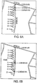
- the pushpins on the image depict the results of using a traditional interpolation technique to geocode addresses 2, 14 and 22 on Bieniek Ave, Adams, Massachusetts, for which the postal authority has assigned the possible addresses of 1 through 99.
- the even-numbered addresses on the full length of the street as indicated by the numbered stars, range only up to 22.
- Traditional interpolation methods assume the existence of addresses 2 through 98 on the even side of the street and therefore locate 2, 14 and 22 as being clustered on one end of the street, which in this instance is incorrect.
- use of the existing geocoding methods can result in errors in analysis and/or logistics where location is a key component. Accordingly, there is a desire and need for more accurate geocoding technique.
- the present invention provides a dynamic geocoding method according to claim 1, and a geocoding system according to claim 7.
- Optional features are set out in the dependent claims.
- Embodiments of the invention described below provide a method and apparatus that improves the positional accuracy of a geocoded point in comparison to traditional goecoding methods and geocoders.
- the method and apparatus disclosed herein utilize externally generated ground truth data (when available) in conjunction with address range information for a given segment (e.g., street segment) to achieve positional accuracy not currently obtainable in the prior art.
- the additional data is searched for and included in the interpolation methodology in a dynamic manner and in real time.
- the embodiments of the invention allow users to introduce/input point data at any time.
- the point data which is external to the native address dictionary, will be considered dynamically at run-time when input addresses are being assigned latitude/longitude coordinates during the interpolation process.
- This capability removes the need of the software vendor to extend the pre-generated georeferenced dictionary via additional processing.
- the embodiments of the invention solve a long-felt need by allowing users to independently improve the quality of the geocoding process through their own efforts.
- FIG. 2 further illustrates the FIG. 1 Main Street segment as interpolated in accordance with an embodiment of the invention.
- the illustrated Main Street segment is for the odd side of Main Street and has an address range of 1 to 99 (odd numbers only) spanning between segment endpoints A and B.
- the coordinates of endpoint A are (X,Y) while the coordinates of endpoint B are (X 1 , Y 1 ).
- a geocoder that can recognize and consider point data (such as e.g., parcel centroids or GPS-generated point files) within e.g., a pre-defined address dictionary, user dictionary or from any other external source, can improve upon the traditional interpolation method and generate a more accurate set of coordinates for the input address.
- the geocoder of the invention determines a different set of coordinates from the prior art geocoder by interpolating between the closest known point with a house number less than 33 (which is 17 or point D) and the known point with a house number greater than 33 (which in this example is the endpoint B having address 99). Accordingly, as can be seen by comparing FIG. 2 to FIG. 1 , the positional accuracy for locating 33 Main Street (point C') has greatly improved.
- FIG. 3 illustrates the results of the interpolation performed in accordance with the invention when an additional point E, having e.g., address 43 Main Street, is available in the pre-defined georeferenced dictionary or from any other external source.
- the proposed interpolation can further refine the location of 33 Main Street by calculating the distance between 17 (point D) and 43 (point E) Main Street and determining where 33 Main Street (point C") is most likely situated.
- FIG. 4 illustrates a method 100 according to an embodiment of the invention.
- FIG. 5 illustrates an example embodiment of a geocoder 200 of the invention.
- the geocoder 200 comprises a computer or processor 202 having geocoding software capable of interpolating data from a variety of data sources and running the method 100 of FIG. 4 .
- the sources illustrated in FIG. 5 include a georeferenced address dictionary 206, a user-supplied point data dictionary/database 208 and web-based sources of address point data 204.
- the web-based sources of address point data 204 can include sources such as the Ordnance Survey in the United Kingdom, the Public Sector Mapping Agencies in Australia, or proprietary data warehouses developed and maintained by organizations and accessible only within those organizations.
- the web-based and user supplied point data dictionaries/database 204, 208 will contain known data points and associated address information and coordinates for each data point.
- the method 100 begins by inputting an address to be geocoded (hereinafter the "input address") at step 102.
- the method 100 determines if a street vector match was found in the georeferenced address dictionary 206. If a match was not found, the input address is compared to non-georeferenced postal data at step 114 and the method 100 completes. The result is the derivation of a latitude/longitude coordinate pair based upon a typically less geographically precise centroid rather than an interpolated street level "hit.” If at step 104, it was determined that there was a street vector match, the method 100 continues at step 106 and captures the address ranges and associated coordinates from the matched street vector.
- a search is made for external point data associated with the matched street vector. The search includes querying the web-based and user-supplied sources of point data 204, 208.
- the method 100 determines if external point data has been found. If external point data has not been found, the method 100 interpolates coordinates of the input address based on the address range coordinates associated with the matched street vector (step 116). If at step 110, it was determined that there is external point data, the method 100 continues at step 112, where the method 100 interpolates coordinates of the input address based upon the address range coordinates associated with the matched street vector and the externally discovered point locations. In a preferred embodiment, interpolation is performed by interpolating between the closest known point with an address less than the input address and the known point with an address greater than the input address (see e.g., the description regarding FIGS. 2 and 3 above). After steps 112 and 116, the method 100 terminates.
- the method 100 is implemented in software and may be stored on a computer readable storage medium such as a hard disk drive, floppy disk, CD-ROM, DVD and sold as an article of manufacture.
- the computer instructions implementing method 100 may also be stored on a network server and subsequently downloaded over a network to a computer system or other device/system.
- the computer instructions implementing the method 100 may also be programmed into various read only memory chips within or attached to the computer 202, if desired.
- the invention's interpolation of the derived location of an input address is a more accurate geographic representation of that address than other methods known in the art because it considers intermediate points whose ground truth is known and accepted as valid. This is evident by comparing the interpolation result shown in FIG. 6A (traditional) with the result illustrated in FIG. 6B .
- the pushpins in FIG. 6B illustrate the vastly improved geocoded locations of the same addresses shown in FIG. 6A , the improvement results from the method 100 performed in accordance with the invention.
- the embodiments of the invention further enable the interpolation methodology to be implemented in a dynamic fashion, consuming user-provided data as it is introduced at any time in the life cycle of the geocoding software. That is, the end result of the invention's geocoding process is an interpolated point that better approximates the ground truth position of the input address based on the combination of known endpoints for the matched street segment as well as the known location of other addresses associated with that segment.
Landscapes
- Engineering & Computer Science (AREA)
- Physics & Mathematics (AREA)
- Theoretical Computer Science (AREA)
- Mathematical Physics (AREA)
- Business, Economics & Management (AREA)
- Educational Administration (AREA)
- Educational Technology (AREA)
- General Physics & Mathematics (AREA)
- Information Retrieval, Db Structures And Fs Structures Therefor (AREA)
- Instructional Devices (AREA)
- Radar Systems Or Details Thereof (AREA)
Description
- The invention relates generally to the field of geocoding and more particularly to a method and apparatus for geocoding with improved positional accuracy.
-
EP 1 788 495 A1 describes a method for representing locations in a geographic data in a manner that facilitates navigation and routing. A core map database includes data that represents public roads in a geographic region. Each of a plurality of location map databases includes data that represent facilities, such as businesses, stores, offices, or other places, that are physically located away from the public network and access to which requires travel on paths away from the public road network. Each of the facilities represented in the location map databases is assigned a location reference code that is associated with data from which a path connecting the facility and the public road network can be determined. -
US 2005/0034074 A1 describes a mapping system which uses aerial photographs to correct geocode data for street addresses. After entering an address, a street map is displayed along with an aerial photo, both of which indicate the street address location based on standard algorithms. The indicator on the aerial map can be moved to accurately align with the location of the entered street address, which corrects the geocode data, allowing further geographical analysis to be performed using the corrected geocode data. The corrected geocode data can be used to more accurately determine distances from the property at the street address to natural hazards such as, coastlines, earthquake faults and flood zones. - Geocoding involves programmatically assigning x and y coordinates (usually but not limited to, earth coordinates--i.e., latitude and longitude) to records, lists and files containing location information (full addresses, partial addresses, zip codes, census FIPS codes, etc.) for cartographic or any other form of spatial analysis or reference. Geocoding is even more broadly described as "mapping your data" in order to visualize information and explore relationships previously unavailable in strict database or spreadsheet analysis.
- A centroid is a geographic center of an entire area, region, boundary, etc. for which the specific geographic area covers.
- Street vectors are address segments of individual streets, which may contain attributes such as address ranges. Street vectors are used in displays of digitized computer-based street maps. Range information on street vectors is typically specified on the left and right side of each vector. They are also used for geocoding a particular address to a particular street segment based on its point along the line segment.
- Geocoding is currently performed by running non-geocoded (referred to hereafter as "raw data") information such as a list of customers through proprietary software and/or data, which performs table lookup, fuzzy logic and address matching against an entire "library" of all known or available address points or street vectors (referred to hereafter as a "georeferenced library") with associated x, y location coordinates. If the raw data matches a point record from the georeferenced library, then the raw data is assigned the same x, y coordinates associated with the matching record from the georeferenced library. If the raw data instead matches a street vector, then the raw data is assigned interpolated x,y coordinates pair based on the x,y coordinates of the high and low address for the matched street vector in the georeferenced library.
- The georeferenced library is compiled from a number of varied sources, depending on the territory, including census information, postal address information, street vectors with associated address ranges, postcode centroids and other various sources of data containing geographic information and/or location geometry. If a raw data address cannot be matched exactly to a specific library street address (known as a "street level hit"), then an attempt is made to match the raw data address to an ever decreasing precision geographic hierarchy of point, line or region geography until a predetermined tolerance for an acceptable match is met. The geographic hierarchy to which a raw data record is finally assigned is also known as the "geocoding precision." Geocoding precision tells how closely the location assigned by the geocoding software matches the true location of the raw data.
-
FIG. 1 of the accompanying drawings illustrates a street segment called Main Street. The illustrated Main Street segment is for the odd side of Main Street and has an address range of 1 to 99 (odd numbers only) spanning between segment endpoints A and B. The coordinates of endpoint A are (X,Y) while the coordinates of endpoint B are (X1, Y1). Heretofore, interpolation of input addresses in a geocoder was accomplished by considering the available high and low address range data in a georeferenced library for the given street segment and calculating where on that segment an input address from the raw data ought to reside based upon the latitude/longitude pairs of those two endpoints. - For example, as illustrated in
FIG. 1 , given the Main Street segment, current interpolation methods will assume that addresses exist at points equidistant from each other and that the determination of where an input address from the raw data resides on a given segment is calculated using the coordinates of the segment endpoints A, B (or nodes) from the georeferenced library. Current interpolation will place an input address of 33 Main Street approximately one third (point C) of the way along the segment. - The disadvantage of the prior art methods is that they fail to consider that houses, buildings, etc. are typically not located at regular intervals along a street vector or sometimes do not utilize the full range of possible address numbers assigned by the postal authority for the street vector. As such, these methods are not as accurate as they should be, which is undesirable. Users of such geocoding methods may assign locations to addresses on a street vector that are incorrect when compared to the actual ground truth positions of addresses on that street vector. For example, traditional interpolation can result in clustering addresses in close proximity at one end of a street vector when the actual addresses are distributed along a greater length of the street vector. In
FIG. 6A , the pushpins on the image depict the results of using a traditional interpolation technique togeocode addresses addresses 2 through 98 on the even side of the street and therefore locate 2, 14 and 22 as being clustered on one end of the street, which in this instance is incorrect. Thus, use of the existing geocoding methods can result in errors in analysis and/or logistics where location is a key component. Accordingly, there is a desire and need for more accurate geocoding technique. - The present invention provides a dynamic geocoding method according to claim 1, and a geocoding system according to claim 7. Optional features are set out in the dependent claims.
- For a better understanding of the invention and to show how the same may be carried into effect, reference will now be made, by way of example, to the accompanying drawings, in which:
-
FIG. 1 illustrates interpolation of an address within a street segment according to conventional geocoding methods; -
FIG. 2 illustrates interpolation of an address within a street segment according to an embodiment of the invention; -
FIG. 3 illustrates a further interpolation of an address within a street segment according to an embodiment of the invention; -
FIG. 4 is a flowchart of a geocoding method according to an embodiment of the invention; -
FIG. 5 illustrates a geocoder constructed in accordance with an embodiment of the invention; and -
FIGS. 6A and 6B illustrate the difference between interpolation results with prior art and interpolation with an embodiment of the current invention for addresses on a street segment in Adams, Massachusetts. - Embodiments of the invention described below provide a method and apparatus that improves the positional accuracy of a geocoded point in comparison to traditional goecoding methods and geocoders. The method and apparatus disclosed herein utilize externally generated ground truth data (when available) in conjunction with address range information for a given segment (e.g., street segment) to achieve positional accuracy not currently obtainable in the prior art. The additional data is searched for and included in the interpolation methodology in a dynamic manner and in real time.
- As set forth above, prior art geocoding methods fail to consider that houses, buildings, etc. are typically not constructed equidistant from each other. Nor do they consider the advent of point data files that are now becoming more available such as for example, point data via parcel centroid data or addresses located via GPS devices. To use this ground truth data optimally, a geocoder must be equipped to consume this additional data in a dynamic fashion, during run-time of the geocoding process, without requiring incremental modification of an underlying georeferenced address dictionary. To date, this has not been done.
-
U.S. Patent no. 6,101,496 , assigned to MapInfo Corporation, reference to which is directed for further details, considered the incorporation of different sources of street and/or address point information in the pre-processing of a native address dictionary upon which input addresses are geocoded. The '496 patent, however, does not disclose or suggest a dynamic ability to consume and consider additional address information to pin point a location within a segment. - The embodiments of the invention, on the other hand, allow users to introduce/input point data at any time. The point data, which is external to the native address dictionary, will be considered dynamically at run-time when input addresses are being assigned latitude/longitude coordinates during the interpolation process. This capability removes the need of the software vendor to extend the pre-generated georeferenced dictionary via additional processing. As such, the embodiments of the invention solve a long-felt need by allowing users to independently improve the quality of the geocoding process through their own efforts.
-
FIG. 2 further illustrates theFIG. 1 Main Street segment as interpolated in accordance with an embodiment of the invention. The illustrated Main Street segment is for the odd side of Main Street and has an address range of 1 to 99 (odd numbers only) spanning between segment endpoints A and B. The coordinates of endpoint A are (X,Y) while the coordinates of endpoint B are (X1, Y1). Using the example above, a geocoder that can recognize and consider point data (such as e.g., parcel centroids or GPS-generated point files) within e.g., a pre-defined address dictionary, user dictionary or from any other external source, can improve upon the traditional interpolation method and generate a more accurate set of coordinates for the input address. - Modifying the example described above, it is now assumed that the location of 17 Main Street is known (point D). The information regarding 17 Main Street may be housed in a pre-defined address dictionary, user-generated input dictionary, or it may be dynamically retrieved from another location (e.g., over the Internet or other connection to an external database). When the user requests the geocoder to locate the position of 33 Main Street, the geocoder of the invention determines a different set of coordinates from the prior art geocoder by interpolating between the closest known point with a house number less than 33 (which is 17 or point D) and the known point with a house number greater than 33 (which in this example is the endpoint B having address 99). Accordingly, as can be seen by comparing
FIG. 2 to FIG. 1 , the positional accuracy for locating 33 Main Street (point C') has greatly improved. -
FIG. 3 illustrates the results of the interpolation performed in accordance with the invention when an additional point E, having e.g., address 43 Main Street, is available in the pre-defined georeferenced dictionary or from any other external source. As illustrated inFIG. 3 , the proposed interpolation can further refine the location of 33 Main Street by calculating the distance between 17 (point D) and 43 (point E) Main Street and determining where 33 Main Street (point C") is most likely situated. -
FIG. 4 illustrates amethod 100 according to an embodiment of the invention.FIG. 5 illustrates an example embodiment of ageocoder 200 of the invention. Thegeocoder 200 comprises a computer orprocessor 202 having geocoding software capable of interpolating data from a variety of data sources and running themethod 100 ofFIG. 4 . The sources illustrated inFIG. 5 include ageoreferenced address dictionary 206, a user-supplied point data dictionary/database 208 and web-based sources ofaddress point data 204. The web-based sources ofaddress point data 204 can include sources such as the Ordnance Survey in the United Kingdom, the Public Sector Mapping Agencies in Australia, or proprietary data warehouses developed and maintained by organizations and accessible only within those organizations. An example of the latter could be a utility company that establishes locations for its physical assets via GPS units. It should be appreciated that any source of address point data may be utilized and the invention is not to be limited to those illustrated inFIG. 5 . The web-based and user supplied point data dictionaries/database - The
method 100 begins by inputting an address to be geocoded (hereinafter the "input address") atstep 102. Atstep 104, themethod 100 determines if a street vector match was found in thegeoreferenced address dictionary 206. If a match was not found, the input address is compared to non-georeferenced postal data atstep 114 and themethod 100 completes. The result is the derivation of a latitude/longitude coordinate pair based upon a typically less geographically precise centroid rather than an interpolated street level "hit." If atstep 104, it was determined that there was a street vector match, themethod 100 continues atstep 106 and captures the address ranges and associated coordinates from the matched street vector. Atstep 108, a search is made for external point data associated with the matched street vector. The search includes querying the web-based and user-supplied sources ofpoint data - At
step 110, themethod 100 determines if external point data has been found. If external point data has not been found, themethod 100 interpolates coordinates of the input address based on the address range coordinates associated with the matched street vector (step 116). If atstep 110, it was determined that there is external point data, themethod 100 continues atstep 112, where themethod 100 interpolates coordinates of the input address based upon the address range coordinates associated with the matched street vector and the externally discovered point locations. In a preferred embodiment, interpolation is performed by interpolating between the closest known point with an address less than the input address and the known point with an address greater than the input address (see e.g., the description regardingFIGS. 2 and 3 above). Aftersteps method 100 terminates. - It should be appreciated that the
method 100 is implemented in software and may be stored on a computer readable storage medium such as a hard disk drive, floppy disk, CD-ROM, DVD and sold as an article of manufacture. The computerinstructions implementing method 100 may also be stored on a network server and subsequently downloaded over a network to a computer system or other device/system. The computer instructions implementing themethod 100 may also be programmed into various read only memory chips within or attached to thecomputer 202, if desired. - As described above, by using intermediate points on a street segment, input from a pre-defined geo-referenced address dictionary, user dictionary, or from other external sources, as opposed to solely considering the known endpoints of a given segment, the invention's interpolation of the derived location of an input address is a more accurate geographic representation of that address than other methods known in the art because it considers intermediate points whose ground truth is known and accepted as valid. This is evident by comparing the interpolation result shown in
FIG. 6A (traditional) with the result illustrated inFIG. 6B . The pushpins inFIG. 6B illustrate the vastly improved geocoded locations of the same addresses shown inFIG. 6A , the improvement results from themethod 100 performed in accordance with the invention. In addition, by including the availability of externally-sourced address point data, the embodiments of the invention further enable the interpolation methodology to be implemented in a dynamic fashion, consuming user-provided data as it is introduced at any time in the life cycle of the geocoding software. That is, the end result of the invention's geocoding process is an interpolated point that better approximates the ground truth position of the input address based on the combination of known endpoints for the matched street segment as well as the known location of other addresses associated with that segment. - While the embodiments of the invention have been described in detail in connection with preferred embodiments known at the time, it should be readily understood that they are not so limited. Rather, the embodiments can be modified to incorporate any number of variations, alterations, substitutions or equivalent arrangements not heretofore described, but which are commensurate with the scope of the invention. Accordingly, the embodiments of the invention are not limited by the foregoing description or drawings, but are only limited by the scope of the appended claims.
Claims (15)
- A dynamic geocoding method comprising the steps of:inputting (102) an address to be geocoded into a geocoder (200) having a processor (202); andoperating the processor (202) to determine (104) if, for said address to be geocoded, a street vector match was found in a georeferenced address dictionary (206) that is in communication with the processor (202), the georeferenced address dictionary (206) comprising street vectors each having respective address ranges and coordinates associated with the address ranges;if it is determined by the processor (202) that there was a street vector match, said method further comprises operating the processor (202) to perform the steps of:capturing (106) an address range and associated coordinates from the matched street vector,determining (110) if external point data associated with the matched street vector exists in a source that is in communication with the processor (202) and external to the georeferenced address dictionary (206), by querying the source to search for the external point data associated with the matched street vector, wherein the external point data comprises known data points and associated address information and coordinates for each data point, and wherein the external point data associated with the matched street vector comprises a known location of another address associated with the matched street vector, andif it is determined that there is external point data, interpolating (112) coordinates of the input address based upon the external point data and the address range coordinates associated with the matched street vector,wherein the georeferenced address dictionary (206) does not need to be extended.
- The method of Claim 1, wherein said source of the external point data is a user-defined data dictionary (208).
- The method of Claim 1, wherein said source of the external point data is a network-based resource (204).
- The method of Claim 1, wherein said source of the external point data is an Internet-based resource (204).
- The method of Claim 1, wherein if it is determined that there is no external point data, the method comprises the step of interpolating (116) coordinates of the input address based upon the address range coordinates associated with the matched street vector.
- The method of Claim 1, wherein if it is determined that there was no street vector match, the method comprises the step of comparing (114) the input address to non-georeferenced postal data.
- A geocoding system (200) comprising:means (202) for inputting (102) to the system an address to be geocoded; andprocessing means (202) arranged to perform processes of:determine (104) if, for said address to be geocoded, a street vector match was found in a georeferenced address dictionary (206) that is in communication with the processor (202), the georeferenced address dictionary (206) comprising street vectors each having respective address ranges and coordinates associated with the address ranges;capture (106), if it is determined that there was a street vector match, an address range and associated coordinates from the matched street vector;determine (110) if external point data associated with the matched street vector exists in a source that is communicatively coupled to the processor (202) and external to the georeferenced address dictionary (206), by querying the source to search for the external point data associated with the matched street vector, wherein the external point data comprises known data points and associated address information and coordinates for each data point, and wherein the external point data associated with the matched street vector comprises a known location of another address associated with the matched street vector; andif it is determined that there is external point data, interpolate (112) coordinates of the input address based upon the external point data and the address range coordinates associated with the matched street vector,wherein the processing means (202) is arranged to perform said processes without needing to extend the georeferenced address dictionary (206).
- The system of Claim 7, wherein said source of the external point data is a user-defined data dictionary (208).
- The system of Claim 7, wherein said source of the external point data is a network-based resource (204).
- The system of Claim 7, wherein said source of the external point data is an Internet-based resource (204).
- The system of Claim 7, further comprising processing means (202) for interpolating (116) coordinates of the input address based upon the address range coordinates associated with the matched street vector, when there is determined to be no external point data.
- The system of Claim 7, further comprising processing means (202) for comparing (114) the input address to non-georeferenced postal data, when there is determined to be no street vector match.
- A geocoding system (200) according to Claim 7, wherein:said source is a dictionary comprising at least one external address point and associated latitude/longitude coordinates for each point; andsaid processing means comprises a processor (202) communicatively coupled to the georeferenced address dictionary (206) and the source, said processor (202) being arranged to receive (102) an address to be geocoded, determine (104) if a street vector match was found in said georeferenced address dictionary, capture (106) an address range and associated coordinates from the matched street vector, search (108) the source to determine if external point data associated with the matched street vector exists, and if it is determined that there is external point data, interpolate (112) coordinates of the input address based upon the address range coordinates associated with the matched street vector and the external point data.
- The system of Claim 13, wherein the source comprises a user-defined dictionary (208) and a network-based dictionary (204).
- The system of Claim 13, wherein the processor (202) is configured to search the source in a real-time manner.
Applications Claiming Priority (3)
| Application Number | Priority Date | Filing Date | Title |
|---|---|---|---|
| US81583606P | 2006-06-23 | 2006-06-23 | |
| US11/703,736 US7539573B2 (en) | 2006-06-23 | 2007-02-08 | Enhanced positional accuracy in geocoding by dynamic interpolation |
| PCT/US2007/013797 WO2008002391A2 (en) | 2006-06-23 | 2007-06-13 | Enhanced positional accuracy in geocoding by dynamic interpolation |
Publications (3)
| Publication Number | Publication Date |
|---|---|
| EP2038677A2 EP2038677A2 (en) | 2009-03-25 |
| EP2038677A4 EP2038677A4 (en) | 2012-08-15 |
| EP2038677B1 true EP2038677B1 (en) | 2018-04-04 |
Family
ID=38846163
Family Applications (1)
| Application Number | Title | Priority Date | Filing Date |
|---|---|---|---|
| EP07835801.7A Ceased EP2038677B1 (en) | 2006-06-23 | 2007-06-13 | Enhanced positional accuracy in geocoding by dynamic interpolation |
Country Status (3)
| Country | Link |
|---|---|
| US (1) | US7539573B2 (en) |
| EP (1) | EP2038677B1 (en) |
| WO (1) | WO2008002391A2 (en) |
Families Citing this family (17)
| Publication number | Priority date | Publication date | Assignee | Title |
|---|---|---|---|---|
| US20070185649A1 (en) * | 2006-02-08 | 2007-08-09 | Tele Atlas North America, Inc. | Map database having address points for determining destinations |
| US7539573B2 (en) * | 2006-06-23 | 2009-05-26 | Pitney Bowes Software Inc. | Enhanced positional accuracy in geocoding by dynamic interpolation |
| US20090070196A1 (en) * | 2007-09-12 | 2009-03-12 | Targus Information Corporation | System and method for developing small geographic area population, household, and demographic count estimates and projections using a master address file |
| US20090327229A1 (en) * | 2008-06-27 | 2009-12-31 | Microsoft Corporation | Automatic knowledge-based geographical organization of digital media |
| WO2010068187A1 (en) * | 2008-12-10 | 2010-06-17 | Tele Atlas North America, Inc. | A map database, having vectors for determining destinations, and vector determination method |
| US8374055B2 (en) * | 2009-06-19 | 2013-02-12 | The United States Of America, As Represented By The Secretary Of The Navy | Acoustic communication and locating devices for underground mines |
| US8850341B2 (en) | 2009-07-29 | 2014-09-30 | Blackberry Limited | Making address book a source of latitude and longitude coordinates |
| EP2282493B1 (en) * | 2009-07-29 | 2017-12-27 | BlackBerry Limited | Making address book a source of latitude and longitude coordinates |
| GB2477306A (en) * | 2010-01-29 | 2011-08-03 | Saudi Post | Assigning postal addresses |
| US8650024B1 (en) * | 2011-04-13 | 2014-02-11 | Google Inc. | Generating address term synonyms |
| JP6142478B2 (en) * | 2012-08-02 | 2017-06-07 | 株式会社デンソー | Database structure of map database and navigation device |
| ITVI20120241A1 (en) * | 2012-09-26 | 2014-03-27 | Geodrome S R L | SYSTEM AND METHOD OF GEOGRAPHICAL CODIFICATION OF DATABASE DATABASES FOR TAX DETECTION |
| EP2932193B1 (en) * | 2012-12-12 | 2025-04-09 | Elise Sarah Hale | Coding system for satellite navigation system |
| US9179257B2 (en) | 2013-08-21 | 2015-11-03 | Pitney Bowes Inc. | Method and system for determining high precision geo-fencing using business property boundaries |
| US10248731B1 (en) * | 2014-05-16 | 2019-04-02 | Corelogic Solutions, Llc | System and method for linking data records for parcels |
| US11462836B2 (en) | 2019-05-09 | 2022-10-04 | Commscope Technologies Llc | Base station antennas having skeletal radio frequency lenses |
| US11343638B2 (en) * | 2020-03-16 | 2022-05-24 | Delhivery Private Limited | System and method for validating accuracy of geographic location for an address |
Family Cites Families (14)
| Publication number | Priority date | Publication date | Assignee | Title |
|---|---|---|---|---|
| US6101496A (en) * | 1998-06-08 | 2000-08-08 | Mapinfo Corporation | Ordered information geocoding method and apparatus |
| CA2414379A1 (en) * | 2000-06-30 | 2002-01-10 | Troy Schultz | Method and apparatus for a gis based search engine utilizing real time advertising |
| US6925307B1 (en) * | 2000-07-13 | 2005-08-02 | Gtech Global Services Corporation | Mixed-mode interaction |
| WO2002063853A2 (en) * | 2000-11-03 | 2002-08-15 | Go2 Systems, Inc. | Unified geographic database and metod of creating, maintaining and using the same |
| AU2002312183B2 (en) * | 2001-05-31 | 2008-09-18 | Mapinfo Corporation | System and method for geocoding diverse address formats |
| US7376636B1 (en) * | 2002-06-07 | 2008-05-20 | Oracle International Corporation | Geocoding using a relational database |
| US7636901B2 (en) * | 2003-06-27 | 2009-12-22 | Cds Business Mapping, Llc | System for increasing accuracy of geocode data |
| US20050216351A1 (en) * | 2004-02-17 | 2005-09-29 | Kenneth Holbert | Methods and systems for recovery of sales and use taxes on cross-state direct sales, mail order, and electronic commerce |
| US7231405B2 (en) * | 2004-05-08 | 2007-06-12 | Doug Norman, Interchange Corp. | Method and apparatus of indexing web pages of a web site for geographical searchine based on user location |
| US7660666B2 (en) * | 2005-11-18 | 2010-02-09 | Navteq North America, Llc | Geographic database with detailed local data |
| US7779059B2 (en) * | 2005-12-22 | 2010-08-17 | Pitney Bowes Software Inc. | Geocoding and address hygiene system employing point level and centerline data sets |
| US7539573B2 (en) * | 2006-06-23 | 2009-05-26 | Pitney Bowes Software Inc. | Enhanced positional accuracy in geocoding by dynamic interpolation |
| US20080201078A1 (en) * | 2006-09-28 | 2008-08-21 | Dudley Fitzpatrick | Apparatuses, Methods and Systems for Determining and Announcing Proximity Between Trajectories |
| EP2115610A2 (en) * | 2006-11-13 | 2009-11-11 | Tele Atlas North America, Inc. | System and method for providing multiple participants with a central access portal to geographic point of interest |
-
2007
- 2007-02-08 US US11/703,736 patent/US7539573B2/en active Active
- 2007-06-13 EP EP07835801.7A patent/EP2038677B1/en not_active Ceased
- 2007-06-13 WO PCT/US2007/013797 patent/WO2008002391A2/en not_active Ceased
Non-Patent Citations (1)
| Title |
|---|
| None * |
Also Published As
| Publication number | Publication date |
|---|---|
| US20070296630A1 (en) | 2007-12-27 |
| WO2008002391A2 (en) | 2008-01-03 |
| EP2038677A4 (en) | 2012-08-15 |
| WO2008002391A3 (en) | 2008-08-07 |
| EP2038677A2 (en) | 2009-03-25 |
| US7539573B2 (en) | 2009-05-26 |
Similar Documents
| Publication | Publication Date | Title |
|---|---|---|
| US7539573B2 (en) | Enhanced positional accuracy in geocoding by dynamic interpolation | |
| US6101496A (en) | Ordered information geocoding method and apparatus | |
| US9430510B2 (en) | Computer implemented methods and systems for multi-level geographic query | |
| US8086556B2 (en) | Geocoding method using multidimensional vector spaces | |
| US7574428B2 (en) | Geometry-based search engine for navigation systems | |
| AU2010200157B2 (en) | Method and system for assessing quality of location content | |
| WO2007108927A2 (en) | Marker placement in a mapping environment | |
| US20050034074A1 (en) | System for increasing accuracy of geocode data | |
| JP3206491B2 (en) | Map information retrieval device | |
| JP3903712B2 (en) | Regional search device | |
| US10119825B1 (en) | System and method for geocoding positional accuracy | |
| US7836047B2 (en) | Method for assignment of point level address geocodes to street networks | |
| US20100125560A1 (en) | Uncertainty-based geocoding for risk management | |
| Karmacharya | Positional accuracy of online geocoding services: case study of Bhaktapur District | |
| JP4510792B2 (en) | LOCATION ANALYSIS DEVICE, LOCATION ANALYSIS METHOD, ITS PROGRAM, AND RECORDING MEDIUM | |
| US11343638B2 (en) | System and method for validating accuracy of geographic location for an address | |
| David et al. | Smart geocoding of objects | |
| CN119377338B (en) | Geographic object processing method, device, electronic device and computer storage medium | |
| Manoruang et al. | Quality analysis of online geocoding services for Thai text addresses | |
| KR101576096B1 (en) | System and method for processing duplicate data | |
| JP2001229182A (en) | Electronic map search method and apparatus, and recording medium storing electronic map search program | |
| CN119293323A (en) | Reverse geocoding data generation method, device, equipment, medium and program product | |
| WO2004097339A1 (en) | Feature set transformation | |
| JP6140495B2 (en) | Information processing apparatus, information processing method, and program | |
| AU2004234414B2 (en) | Feature set transformation |
Legal Events
| Date | Code | Title | Description |
|---|---|---|---|
| PUAI | Public reference made under article 153(3) epc to a published international application that has entered the european phase |
Free format text: ORIGINAL CODE: 0009012 |
|
| 17P | Request for examination filed |
Effective date: 20090114 |
|
| AK | Designated contracting states |
Kind code of ref document: A2 Designated state(s): AT BE BG CH CY CZ DE DK EE ES FI FR GB GR HU IE IS IT LI LT LU LV MC MT NL PL PT RO SE SI SK TR |
|
| AX | Request for extension of the european patent |
Extension state: AL BA HR MK RS |
|
| RIC1 | Information provided on ipc code assigned before grant |
Ipc: G01C 21/32 20060101ALI20090325BHEP Ipc: G06F 17/00 20060101ALI20090325BHEP Ipc: G01C 21/30 20060101AFI20090325BHEP |
|
| DAX | Request for extension of the european patent (deleted) | ||
| RBV | Designated contracting states (corrected) |
Designated state(s): DE FR GB |
|
| REG | Reference to a national code |
Ref country code: DE Ref legal event code: R079 Ref document number: 602007054474 Country of ref document: DE Free format text: PREVIOUS MAIN CLASS: G01S0005140000 Ipc: G01C0021300000 |
|
| A4 | Supplementary search report drawn up and despatched |
Effective date: 20120717 |
|
| RIC1 | Information provided on ipc code assigned before grant |
Ipc: G01C 21/30 20060101AFI20120712BHEP Ipc: G01C 21/32 20060101ALI20120712BHEP Ipc: G06F 17/00 20060101ALI20120712BHEP |
|
| 17Q | First examination report despatched |
Effective date: 20121220 |
|
| GRAP | Despatch of communication of intention to grant a patent |
Free format text: ORIGINAL CODE: EPIDOSNIGR1 |
|
| INTG | Intention to grant announced |
Effective date: 20171031 |
|
| GRAS | Grant fee paid |
Free format text: ORIGINAL CODE: EPIDOSNIGR3 |
|
| GRAJ | Information related to disapproval of communication of intention to grant by the applicant or resumption of examination proceedings by the epo deleted |
Free format text: ORIGINAL CODE: EPIDOSDIGR1 |
|
| GRAL | Information related to payment of fee for publishing/printing deleted |
Free format text: ORIGINAL CODE: EPIDOSDIGR3 |
|
| GRAR | Information related to intention to grant a patent recorded |
Free format text: ORIGINAL CODE: EPIDOSNIGR71 |
|
| GRAA | (expected) grant |
Free format text: ORIGINAL CODE: 0009210 |
|
| INTC | Intention to grant announced (deleted) | ||
| INTG | Intention to grant announced |
Effective date: 20180216 |
|
| AK | Designated contracting states |
Kind code of ref document: B1 Designated state(s): DE FR GB |
|
| REG | Reference to a national code |
Ref country code: GB Ref legal event code: FG4D |
|
| REG | Reference to a national code |
Ref country code: DE Ref legal event code: R096 Ref document number: 602007054474 Country of ref document: DE |
|
| REG | Reference to a national code |
Ref country code: FR Ref legal event code: PLFP Year of fee payment: 12 |
|
| REG | Reference to a national code |
Ref country code: DE Ref legal event code: R097 Ref document number: 602007054474 Country of ref document: DE |
|
| PLBE | No opposition filed within time limit |
Free format text: ORIGINAL CODE: 0009261 |
|
| STAA | Information on the status of an ep patent application or granted ep patent |
Free format text: STATUS: NO OPPOSITION FILED WITHIN TIME LIMIT |
|
| 26N | No opposition filed |
Effective date: 20190107 |
|
| PGFP | Annual fee paid to national office [announced via postgrant information from national office to epo] |
Ref country code: FR Payment date: 20190625 Year of fee payment: 13 |
|
| PGFP | Annual fee paid to national office [announced via postgrant information from national office to epo] |
Ref country code: DE Payment date: 20190627 Year of fee payment: 13 Ref country code: GB Payment date: 20190627 Year of fee payment: 13 |
|
| REG | Reference to a national code |
Ref country code: DE Ref legal event code: R119 Ref document number: 602007054474 Country of ref document: DE |
|
| GBPC | Gb: european patent ceased through non-payment of renewal fee |
Effective date: 20200613 |
|
| PG25 | Lapsed in a contracting state [announced via postgrant information from national office to epo] |
Ref country code: FR Free format text: LAPSE BECAUSE OF NON-PAYMENT OF DUE FEES Effective date: 20200630 Ref country code: GB Free format text: LAPSE BECAUSE OF NON-PAYMENT OF DUE FEES Effective date: 20200613 |
|
| PG25 | Lapsed in a contracting state [announced via postgrant information from national office to epo] |
Ref country code: DE Free format text: LAPSE BECAUSE OF NON-PAYMENT OF DUE FEES Effective date: 20210101 |