EP1902276B1 - Device for assisting a vertical guidance approach for aircraft - Google Patents
Device for assisting a vertical guidance approach for aircraft Download PDFInfo
- Publication number
- EP1902276B1 EP1902276B1 EP06778852.1A EP06778852A EP1902276B1 EP 1902276 B1 EP1902276 B1 EP 1902276B1 EP 06778852 A EP06778852 A EP 06778852A EP 1902276 B1 EP1902276 B1 EP 1902276B1
- Authority
- EP
- European Patent Office
- Prior art keywords
- aircraft
- approach
- guidance
- vertical
- performance
- Prior art date
- Legal status (The legal status is an assumption and is not a legal conclusion. Google has not performed a legal analysis and makes no representation as to the accuracy of the status listed.)
- Not-in-force
Links
Images
Classifications
-
- G—PHYSICS
- G05—CONTROLLING; REGULATING
- G05D—SYSTEMS FOR CONTROLLING OR REGULATING NON-ELECTRIC VARIABLES
- G05D1/00—Control of position, course or altitude of land, water, air, or space vehicles, e.g. automatic pilot
- G05D1/04—Control of altitude or depth
- G05D1/06—Rate of change of altitude or depth
- G05D1/0607—Rate of change of altitude or depth specially adapted for aircraft
- G05D1/0653—Rate of change of altitude or depth specially adapted for aircraft during a phase of take-off or landing
- G05D1/0676—Rate of change of altitude or depth specially adapted for aircraft during a phase of take-off or landing specially adapted for landing
-
- G—PHYSICS
- G01—MEASURING; TESTING
- G01C—MEASURING DISTANCES, LEVELS OR BEARINGS; SURVEYING; NAVIGATION; GYROSCOPIC INSTRUMENTS; PHOTOGRAMMETRY OR VIDEOGRAMMETRY
- G01C23/00—Combined instruments indicating more than one navigational value, e.g. for aircraft; Combined measuring devices for measuring two or more variables of movement, e.g. distance, speed or acceleration
Definitions
- the present invention relates to an approach aid device which is mounted on an aircraft, in particular a transport aircraft, and which is intended to assist said aircraft at least during an approach with vertical guidance.
- the performance of the aircraft to be taken into account during an approach depends, in particular, on the accuracy of the current position of the aircraft, which is determined periodically during the flight.
- This current position is generally determined from position data which is generated by at least one onboard receiver which cooperates with a conventional global satellite positioning system, for example of the GPS ("Global Positioning System") type or type GALILEO.
- the GNSS reinforcement means consist in improving the performance of the satellite positioning system used (precision, integrity, continuity of service and availability), and include systems acting via GBAS ground stations ( “Ground Based Augmentation System”) or via geostationary satellites type SBAS ("Geostationary Satellite Based Augmentation System” in English), or systems performing an autonomous improvement, that is to say, which is put exclusively using means present on board the aircraft type ABAS ("Airborne Based Augmentation System” in English).
- GBAS and SBAS type reinforcement systems therefore require the use of external elements, whereas an ABAS type reinforcement system is completely autonomous. The latter is therefore to be preferred, especially since an SBAS-type system for example is not usable on the entire terrestrial globe, since the associated network of ground stations only has a partial coverage of the terrestrial globe.
- U.S. 5,945,943 a particular method of approach assistance that uses two DGPS receivers, each of which provides position information. These two position information are used by an autopilot to carry out the guidance of the aircraft during the approach.
- the document US-A-5,677,689 describes a steering assistance with poor visibility in the final.
- the present invention relates to an approach aid device which is mounted on an aircraft, in particular an aircraft, for example a transport aircraft, and which is intended to assist said aircraft, autonomously and particularly efficiently, at least during an approach with vertical guidance APV aforementioned type along an axis of approach.
- Said approach aid according to the invention is therefore autonomous (ABAS-type aforementioned), since the means used to allow an approach with vertical guidance are all on board the aircraft.
- said inertial reference system uses a particularly powerful algorithm to calculate said hybrid position of the aircraft. More precisely, it uses a usual hybridization algorithm called "precision-AIME” which has many advantages (precision, continuity, ). Note that the integrity of the approach axis data is provided by a cyclic redundant monitoring type CRC ("Cyclic Redundancy Check” in English), in the multimode receiver landing aid.
- CRC Cyclic Redundancy Check
- the approach aid according to the invention can provide assistance both in automatic guidance, as in manual guidance.
- said multimode landing aid receiver comprises an integrated monitoring means, which monitors performance parameters relating to the hybrid position provided by said inertial reference system, and which transmits the results of this monitoring ( in general via a guiding means which consolidates them) to a visualization means which is capable of presenting these results to a pilot of the aircraft. Therefore, depending on the actual performance (including vertical) thus provided, the pilot is notified of the ability of the aircraft to achieve (or not) an approach with vertical guidance APV type.
- said flight management system determines an auxiliary position corresponding to the position of the aircraft and, before the capture of said approach axis, said approach assist device complies with the invention uses, in the usual way, this auxiliary position to guide the aircraft.
- this auxiliary position to guide the aircraft.
- the guidance of the aircraft is carried out in the usual manner, that is to say with the help of the position calculated by the flight management system.
- the hybrid position determined by the inertial reference system it is taken into account from the beginning of the capture of the approach axis.
- the particular vertical performances concerning this position must make it possible to respect the above-mentioned APV1 or APV2 performance levels, making it possible to implement an approach with vertical guidance of the APV type.
- Said approach assisting device 1 according to the invention is therefore autonomous (ABAS-type aforementioned), since the means used to allow an approach with vertical guidance (APV approach) are all on board the aircraft.
- said flight management system 2 determines an auxiliary position corresponding to the position of the aircraft and, before the capture of said approach axis, said approach aid 1 complies with the The invention uses, in the usual way, this auxiliary position to guide the aircraft.
- this auxiliary position is used, in the usual way, to guide the aircraft.
- the guidance of the aircraft is carried out in the usual manner, that is to say with the help of the position calculated by the flight management system 2.
- Quant at the hybrid position determined by the inertial reference system 3 it is taken into account from the beginning of the capture of the approach axis.
- the notably vertical performances concerning this position must make it possible to respect the aforementioned levels of performance APV1 or APV2, allowing the implementation of an approach with vertical guidance of the APV type.
- said multimode landing aid receiver 4 is able to allow the implementation of any type of approach (precision, non precision, APV).
- the device 1 makes it possible to provide assistance both in automatic guidance (means 8) and during manual guidance (visualization means 10).
- said inertial reference system 3 for example of the ADIRU ("Air Data / Inertial Reference Unit") type, uses, to determine the current hybrid position of the aircraft, a usual hybridization algorithm of type "precision-AIME".
- ADIRU Air Data / Inertial Reference Unit
- Such an algorithm "precision-AIME” is particularly precise (generally ⁇ 6 meters in horizontal, and ⁇ 9 meters in vertical) and very powerful. Such a use makes it possible to increase the precision of the approach aid device 1 according to the invention.
- said multimode landing aid receiver 4 further includes an integrated monitoring means 17.
- This monitoring means 17 monitors performance parameters relating to the hybrid position provided by said inertial reference system 3. The results of this monitoring are transmitted to a display means (for example by means of display 10) which is likely to present these results to a pilot of the aircraft. It will be noted that the monitoring means 17 of the multimode landing aid receiver 4 do not transmit the results of its monitoring directly to the display means, but to a usual guiding means which consolidates them, then sends them to said means of landing. visualiation. Therefore, depending on the actual performance (including vertical) thus provided, the pilot is notified of the ability of the aircraft to achieve (or not) an approach with vertical guidance APV type.
Description
La présente invention concerne un dispositif d'aide à l'approche qui est monté sur un aéronef, en particulier un avion de transport, et qui est destiné à aider ledit aéronef au moins lors d'une approche avec guidage vertical.The present invention relates to an approach aid device which is mounted on an aircraft, in particular a transport aircraft, and which is intended to assist said aircraft at least during an approach with vertical guidance.
On sait que les approches publiées actuelles, en vue de l'atterrissage d'un avion sur une piste d'atterrissage, se distinguent en deux catégories :
- les approches dites de "non précision" (en anglais "non precision approach"), pour lesquelles aucune exigence de performance verticale n'est imposée ; et
- les approches dites de "précision", telles que par exemple une approche de type ILS ("Instrument Landing System" en anglais, c'est-à-dire système d'atterrissage aux instruments), pour lesquelles des exigences de performance latérale et verticale sont imposées.
- the so-called "non precision approach", for which no vertical performance requirement is imposed; and
- the so-called "precision" approaches, such as for example an ILS ("Instrument Landing System") approach, for which lateral and vertical performance requirements are required are imposed.
Les approches de précision présentent des hauteurs de décision à respecter plus faibles que les approches de non précision.Precision approaches have lower decision-making heights than non-precision approaches.
Les performances de l'aéronef à prendre en compte lors d'une approche dépendent, notamment, de la précision de la position courante de l'aéronef, qui est déterminée de façon périodique au cours du vol. Cette position courante est déterminée en général à partir de données de position qui sont engendrées par au moins un récepteur embarqué qui coopère avec un système usuel de positionnement global par satellites, par exemple de type GPS ("Global Positioning System" en anglais) ou de type GALILEO.The performance of the aircraft to be taken into account during an approach depends, in particular, on the accuracy of the current position of the aircraft, which is determined periodically during the flight. This current position is generally determined from position data which is generated by at least one onboard receiver which cooperates with a conventional global satellite positioning system, for example of the GPS ("Global Positioning System") type or type GALILEO.
On sait par ailleurs qu'il existe des moyens de renforcement, par exemple de type GNSS ("Global Navigation Satellite System" en anglais), qui ont pour but d'améliorer les performances du récepteur utilisé, qui coopère avec un système de positionnement par satellites. L'utilisation de tels moyens de renforcement a entraîné l'émergence de nouvelles approches basées uniquement sur des critères de performances. Ces nouvelles approches se situent entre les approches de précision et les approches de non précision précitées. Ces nouvelles approches sont dites "approches avec guidage vertical" ou approches APV ("APproach with Vertical guidance" en anglais). Ces approches APV présentent deux niveaux de performance prédéterminés différents : APV1 et APV2. Les hauteurs de décision associées à ces deux niveaux de performance sont comprises entre les hauteurs de décision des approches de précision et les hauteurs de décision des approches de non précision.It is also known that there are reinforcement means, for example of the GNSS ("Global Navigation Satellite System") type, which aim to improve the performance of the receiver used, which cooperates with a satellite positioning system. The use of such reinforcement means has led to the emergence of new approaches based solely on performance criteria. These new approaches lie between the precision approaches and the aforementioned non-precision approaches. These new approaches are called "approaches with vertical guidance" or APV approaches ("APproach with Vertical Guidance" in English). These APV approaches have two different predetermined performance levels: APV1 and APV2. The decision heights associated with these two performance levels are between the decision heights of the precision approaches and the decision heights of the non-precision approaches.
On sait que les moyens de renforcement GNSS consistent en l'amélioration des performances du système de positionnement par satellites utilisé (précision, intégrité, continuité de service et disponibilité), et comportent des systèmes agissant par l'intermédiaire de stations sol de type GBAS ("Ground Based Augmentation System" en anglais) ou par l'intermédiaire de satellites géostationnaires de type SBAS ("geostationary Satellite Based Augmentation System" en anglais), ou des systèmes réalisant une amélioration autonome, c'est-à-dire qui est mise en oeuvre exclusivement à l'aide de moyens présents à bord de l'aéronef de type ABAS ("Airborne Based Augmentation System" en anglais).It is known that the GNSS reinforcement means consist in improving the performance of the satellite positioning system used (precision, integrity, continuity of service and availability), and include systems acting via GBAS ground stations ( "Ground Based Augmentation System") or via geostationary satellites type SBAS ("Geostationary Satellite Based Augmentation System" in English), or systems performing an autonomous improvement, that is to say, which is put exclusively using means present on board the aircraft type ABAS ("Airborne Based Augmentation System" in English).
Des systèmes de renforcement de type GBAS et SBAS nécessitent donc l'utilisation d'éléments extérieurs, alors qu'un système de renforcement de type ABAS est complètement autonome. Ce dernier est donc à privilégier, d'autant plus qu'un système de type SBAS par exemple n'est pas utilisable sur tout le globe terrestre, puisque le réseau de stations sol associé présente uniquement une couverture partielle du globe terrestre.
Par ailleurs, on connaît par le document
Moreover, we know from the document
La présente invention concerne un dispositif d'aide à l'approche qui est monté sur un aéronef, en particulier un avion, par exemple un avion de transport, et qui est destiné à aider ledit aéronef, de façon autonome et particulièrement performante, au moins lors d'une approche avec guidage vertical de type APV précité suivant un axe d'approche.The present invention relates to an approach aid device which is mounted on an aircraft, in particular an aircraft, for example a transport aircraft, and which is intended to assist said aircraft, autonomously and particularly efficiently, at least during an approach with vertical guidance APV aforementioned type along an axis of approach.
A cet effet, selon l'invention, ledit dispositif d'aide à l'approche est remarquable en ce qu'il comporte :
- un système de gestion de vol qui détermine ledit axe d'approche ;
- un système de référence inertiel, qui élabore des données de position inertielles, qui reçoit des données de position GNSS de l'aéronef, et qui, à l'aide desdites données de position reçues et desdites données de position inertielles élaborées, détermine une position hybride de l'aéronef. Dans le cadre de la présente invention, on appelle cette position "position hybride", car elle est obtenue à partir de données de types différents (données de position, données de position inertielles), comme précisé ci-dessous ;
- un récepteur multimode d'aide à l'atterrissage, par exemple de type MMR ("Multi Mode Receiver" en anglais), qui est relié audit système de gestion de vol et audit système de référence inertiel, qui reçoit des informations relatives audit axe d'approche et à ladite position hybride, et qui en déduit des écarts angulaires latéraux et verticaux, au moins dès la capture dudit axe d'approche ; et
- un système de guidage qui est relié audit récepteur multimode d'aide à l'atterrissage et qui reçoit lesdits écarts angulaires latéraux et verticaux et les utilise pour le guidage de l'aéronef, au moins dès la capture dudit axe d'approche.
- a flight management system that determines said approach axis;
- an inertial reference system, which generates inertial position data, receives GNSS position data from the aircraft, and, using said received position data and said inertial position data, determines a hybrid position of the aircraft. In the context of the present invention, this position is called "hybrid position" because it is obtained from data of different types (position data, inertial position data), as specified below;
- a multimode landing aid receiver, for example of MMR type ("Multi Mode Receiver" in English), which is connected to said flight management system and to said inertial reference system, which receives information relating to said axis of flight. approach and to said hybrid position, and which deduces lateral and vertical angular deviations, at least as soon as said approach axis is captured; and
- a guidance system which is connected to said multimode landing aid receiver and which receives said lateral and vertical angular deviations and uses them for the guidance of the aircraft, at least as soon as said approach axis is captured.
Ledit dispositif d'aide à l'approche conforme à l'invention est donc autonome (de type ABAS précité), puisque les moyens utilisés pour permettre une approche avec guidage vertical se trouvent tous à bord de l'aéronef.Said approach aid according to the invention is therefore autonomous (ABAS-type aforementioned), since the means used to allow an approach with vertical guidance are all on board the aircraft.
De plus, grâce à l'invention, ledit système de gestion de vol, par exemple de type FMS ("Flight Management System" en anglais), est situé hors de la boucle de guidage lors du guidage de l'aéronef le long dudit axe d'approche en vue de l'atterrissage. Ceci présente plusieurs avantages et permet en particulier, comme précisé ci-dessous :
- d'obtenir une position de l'aéronef plus précise et intègre que celle obtenue de façon usuelle par ledit système de gestion de vol de type FMS, puisque l'on utilise uniquement des systèmes de niveau de développement élevé (système de référence inertiel, récepteur multimode d'aide à l'atterrissage, système de guidage) dans la boucle de position/guidage, ce qui n'est pas le cas pour le système de gestion de vol de type FMS ;
- de réduire les temps de latence dus au transfert des informations de positionnement dans la boucle de navigation/guidage ; et
- d'améliorer la précision et l'intégrité verticales et horizontales.
- to obtain a position of the aircraft more precise and integrated than that obtained in the usual way by said FMS flight management system, since only systems of high level of development are used (inertial reference system, receiver multi-mode landing aid, guidance system) in the position / guidance loop, which is not the case for the FMS flight management system;
- reduce latency due to the transfer of positioning information in the navigation / guidance loop; and
- improve vertical and horizontal accuracy and integrity.
En particulier, pour augmenter la précision de l'aide apportée par le dispositif conforme à l'invention, ledit système de référence inertiel utilise un algorithme particulièrement performant pour calculer ladite position hybride de l'aéronef. Plus précisément, il utilise un algorithme d'hybridation usuel dit "precision-AIME" qui présente de nombreux avantages (précision, continuité, ...). On notera que l'intégrité des données d'axe d'approche est assurée par une surveillance redondante cyclique, de type CRC ("Cyclic Redundancy Check" en anglais), dans le récepteur multimode d'aide à l'atterrissage.In particular, to increase the accuracy of the assistance provided by the device according to the invention, said inertial reference system uses a particularly powerful algorithm to calculate said hybrid position of the aircraft. More precisely, it uses a usual hybridization algorithm called "precision-AIME" which has many advantages (precision, continuity, ...). Note that the integrity of the approach axis data is provided by a cyclic redundant monitoring type CRC ("Cyclic Redundancy Check" in English), in the multimode receiver landing aid.
Ledit système de guidage comporte :
- des moyens, par exemple un pilote automatique, pour guider automatiquement l'aéronef, en tenant compte desdits écarts angulaires latéraux et verticaux déterminés par le récepteur multimode d'aide à l'atterrissage ; et/ou
- au moins un moyen de visualisation pour afficher, sur au moins un écran de visualisation, lesdits écarts angulaires latéraux et verticaux issus dudit récepteur multimode d'aide à l'atterrissage et des indications de guidage relatives auxdits écarts angulaires.
- means, for example an autopilot, for automatically guiding the aircraft, taking into account said lateral and vertical angular deviations determined by the multimode landing aid receiver; and or
- at least one display means for displaying, on at least one display screen, said lateral and vertical angular deviations from said multimode landing aid receiver and guidance indications relating to said angular gaps.
Ainsi, le dispositif d'aide à l'approche conforme à l'invention permet d'apporter une aide aussi bien lors d'un guidage automatique, que lors d'un guidage manuel.Thus, the approach aid according to the invention can provide assistance both in automatic guidance, as in manual guidance.
Ledit dispositif comporte, de plus, un récepteur :
- qui coopère avec un système de positionnement par satellites, par exemple de type GPS ou autre ;
- qui est intégré dans ledit récepteur multimode d'aide à l'atterrissage ; et
- qui élabore lesdites données de position de l'aéronef qui sont ensuite transmises au moins audit système de référence inertiel.
- which cooperates with a satellite positioning system, for example GPS or other type;
- which is integrated in said multimode landing aid receiver; and
- which develops said position data of the aircraft which are then transmitted at least to said inertial reference system.
Selon l'invention, ledit récepteur multimode d'aide à l'atterrissage comporte un moyen de surveillance intégré, qui surveille des paramètres de performance relatifs à la position hybride fournie par ledit système de référence inertiel, et qui transmet les résultats de cette surveillance (en général via un moyen de guidage qui les consolide) à un moyen de visualisation qui est susceptible de présenter ces résultats à un pilote de l'aéronef. Par conséquent, en fonction des performances effectives (notamment verticales) ainsi fournies, le pilote est averti de la capacité de l'aéronef à réaliser (ou non) une approche avec guidage vertical de type APV.According to the invention, said multimode landing aid receiver comprises an integrated monitoring means, which monitors performance parameters relating to the hybrid position provided by said inertial reference system, and which transmits the results of this monitoring ( in general via a guiding means which consolidates them) to a visualization means which is capable of presenting these results to a pilot of the aircraft. Therefore, depending on the actual performance (including vertical) thus provided, the pilot is notified of the ability of the aircraft to achieve (or not) an approach with vertical guidance APV type.
Dans ce cas, de préférence, ledit moyen de surveillance peut émettre des résultats qui sont relatifs respectivement aux situations suivantes :
- une première performance (ou niveau de performance) APV2 prédéterminée, relative à ladite approche avec guidage vertical, est tenue par l'aéronef ;
- ladite première performance APV2 n'est pas tenue par l'aéronef, mais une seconde performance (ou niveau de performance) APV1 moins stricte, également relative à ladite approche avec guidage vertical, est tenue par l'aéronef ;
- ladite seconde performance APV1 n'est pas tenue par l'aéronef, mais l'approche peut quand même être poursuivie ; et
- les performances sont insuffisantes pour poursuivre l'approche.
- a first performance (or performance level) APV2 predetermined, relating to said approach with vertical guidance, is held by the aircraft;
- said first performance APV2 is not held by the aircraft, but a second performance (or performance level) APV1 less strict, also relating to said approach with vertical guidance, is held by the aircraft;
- said second performance APV1 is not held by the aircraft, but the approach can still be continued; and
- performance is insufficient to continue the approach.
Par ailleurs, dans un mode de réalisation particulier, ledit système de gestion de vol détermine une position auxiliaire correspondant à la position de l'aéronef et, avant la capture dudit axe d'approche, ledit dispositif d'aide à l'approche conforme à l'invention utilise, de façon usuelle, cette position auxiliaire pour guider l'aéronef. Ainsi, avant la capture de l'axe d'approche, le guidage de l'aéronef est réalisé de façon usuelle, c'est-à-dire avec l'aide de la position calculée par le système de gestion de vol. Quant à la position hybride déterminée par le système de référence inertiel, elle est prise en compte dès le début de la capture de l'axe d'approche. Les performances notamment verticales concernant cette position, doivent permettre de respecter les niveaux de performance APV1 ou APV2 précités, permettant de mettre en oeuvre une approche avec guidage vertical de type APV.Furthermore, in a particular embodiment, said flight management system determines an auxiliary position corresponding to the position of the aircraft and, before the capture of said approach axis, said approach assist device complies with the invention uses, in the usual way, this auxiliary position to guide the aircraft. Thus, before the capture of the approach axis, the guidance of the aircraft is carried out in the usual manner, that is to say with the help of the position calculated by the flight management system. As for the hybrid position determined by the inertial reference system, it is taken into account from the beginning of the capture of the approach axis. The particular vertical performances concerning this position must make it possible to respect the above-mentioned APV1 or APV2 performance levels, making it possible to implement an approach with vertical guidance of the APV type.
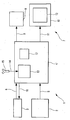
L'unique figure du dessin annexé fera bien comprendre comment l'invention peut être réalisée. Cette figure unique est le schéma synoptique d'un dispositif d'aide à l'approche conforme à l'invention.The sole figure of the appended drawing will make it clear how the invention can be realized. This single figure is the block diagram of an approach aid according to the invention.
Le dispositif 1 conforme à l'invention et représenté schématiquement sur la figure, est destiné à aider un aéronef non représenté, en particulier un avion, lors d'une approche d'un aéroport en vue d'un atterrissage sur une piste d'atterrissage. Plus précisément, ledit dispositif 1 est destiné à aider l'aéronef au moins lors d'une approche avec guidage vertical du type connu APV ("APproach with Vertical guidance" en anglais). Une telle approche APV (qui concerne une approche suivant un axe d'approche) est intermédiaire entre une approche de précision et une approche de non précision. De plus, une telle approche APV présente de façon connue deux niveaux de performance prédéterminés différents : APV1 et APV2. Les hauteurs de décision associées à ces deux niveaux de performance APV1 et APV2 sont comprises entre les hauteurs de décision des approches de précision et les hauteurs de décision des approches de non précision. A titre d'illustration, en ce qui concerne la précision horizontale de navigation (95%), les exigences sont de :
- 220 mètres pour une approche de non précision ;
- 16 mètres pour le niveau de performance APV1 ;
- 16 mètres pour le niveau de performance APV2 ; et
- 16 mètres pour une approche de précision.
- 220 meters for a non-precision approach;
- 16 meters for performance level APV1;
- 16 meters for APV2 performance level; and
- 16 meters for a precision approach.
De plus, en ce qui concerne la précision verticale de navigation (95%), les exigences sont :
- non applicables pour une approche de non précision (absence d'exigence de précision verticale de navigation) ;
- de 20 mètres pour le niveau de performance APV1 ;
de 8 mètres pour le niveau de performance APV2 ; et- de 4 à 6 mètres pour une approche de précision.
- not applicable for a non-precision approach (no requirement for vertical precision of navigation);
- 20 meters for performance level APV1;
- 8 meters for the APV2 performance level; and
- from 4 to 6 meters for a precision approach.
Selon l'invention, ledit dispositif 1 comporte :
- un système de gestion de vol 2, de préférence de type FMS ("Flight Management System" en anglais), qui détermine de façon usuelle l'axe d'approche selon lequel est réalisée l'approche. De façon usuelle, lors d'une phase d'approche, l'aéronef est tout d'abord guidé de manière à capturer cet axe d'approche, c'est-à-dire à le rejoindre, puis, dès qu'il a capturé cet axe d'approche, à le suivre jusqu'à l'atterrissage ;
- un système de référence inertiel 3, par exemple de type ADIRS ("Air Data Inertial Reference System" en anglais), qui élabore de façon usuelle des données de position inertielles, qui reçoit de plus des données de position de l'aéronef, comme précisé ci-dessous, et qui, à l'aide des données de position reçues et des données de position inertielles élaborées, détermine une position de l'aéronef dite position hybride. Dans le cadre de la présente invention, on parle de "position hybride", car la position de l'aéronef est déterminée (de façon usuelle) à partir de données de types différents (données de position, données de position inertielles) ;
- un récepteur multimode d'aide à l'atterrissage 4, de préférence de type MMR ("Multi Mode Receiver" en anglais), qui est relié audit système de gestion de vol 2 par l'intermédiaire d'une liaison 5 et audit système de référence inertiel 3 par
l'intermédiaire d'une liaison 6, qui reçoit des informations relatives audit axe d'approche et à ladite position hybride respectivement desdits systèmes 2et 3, et qui en déduit de façon usuelle d'éventuels écarts angulaires latéraux et verticaux ; et - un système de guidage 7, précisé ci-dessous, qui reçoit lesdits écarts angulaires latéraux et verticaux déterminés par ledit récepteur multimode d'aide à l'atterrissage 4 et qui utilise ces écarts pour le guidage de l'aéronef, ceci dès la capture dudit axe d'approche.
- a
flight management system 2, preferably of the FMS type ("Flight Management System" in English), which determines in the usual way the axis of approach according to which the approach is carried out. In the usual way, during an approach phase, the aircraft is first guided so as to capture this approach axis, that is to say to join it, then, as soon as it has captured this axis of approach, to follow it until landing; - an
inertial reference system 3, for example of the ADIRS type ("Air Data Inertial Reference System" in English), which usually develops inertial position data, which also receives position data from the aircraft, as specified below, and which, using the position data received and the inertial position data developed, determines a position of the so-called hybrid position aircraft. In the context of the present invention, the term "hybrid position" is used because the position of the aircraft is determined (in the usual way) from data of different types (position data, inertial position data); - a multimode
landing aid receiver 4, preferably of the MMR type ("Multi Mode Receiver" in English), which is connected to saidflight management system 2 via a link 5 and to saidinertial reference 3 via alink 6, which receives information relating to said approach axis and to said hybrid position respectively of saidsystems - a
guidance system 7, specified below, which receives said lateral and vertical angular deviations determined by said multimodelanding aid receiver 4 and which uses these deviations for the guidance of the aircraft, this as soon as the capture of said approach axis.
Ledit dispositif d'aide à l'approche 1 conforme à l'invention est donc autonome (de type ABAS précité), puisque les moyens utilisés pour permettre une approche avec guidage vertical (approche APV) se trouvent tous à bord de l'aéronef.Said
De plus, grâce à l'invention, le système de gestion de vol 2, par exemple de type FMS ("Flight Management System" en anglais), est situé hors de la boucle de guidage lors du guidage de l'aéronef le long dudit axe d'approche en vue de l'atterrissage. Ceci présente plusieurs avantages et permet en particulier :
- d'obtenir une position de l'aéronef plus précise et intègre que celle obtenue de façon usuelle par ledit système de gestion de vol 2, puisque l'on utilise ainsi uniquement des systèmes de niveau de développement élevé (système de référence inertiel 3, récepteur multimode d'aide à l'atterrissage 4, système de guidage 7) dans la boucle de position/guidage, ce qui n'est pas le cas pour le système de gestion de vol 2 ;
- de réduire les temps de latence dus au transfert des informations de positionnement dans la boucle de navigation/guidage ; et
- d'améliorer la précision et l'intégrité verticales.
- to obtain a position of the aircraft more accurate and integrated than that obtained in the usual way by said
flight management system 2, since one thus uses only systems of high development level (inertial reference system 3, receivermultimode landing aid 4, guidance system 7) in the position / guidance loop, which is not the case for theflight management system 2; - reduce latency due to the transfer of positioning information in the navigation / guidance loop; and
- improve vertical accuracy and integrity.
Dans un mode de réalisation particulier, ledit système de gestion de vol 2 détermine une position auxiliaire correspondant à la position de l'aéronef et, avant la capture dudit axe d'approche, ledit dispositif d'aide à l'approche 1 conforme à l'invention utilise, de façon usuelle, cette position auxiliaire pour guider l'aéronef. Ainsi, avant la capture de l'axe d'approche, le guidage de l'aéronef est réalisé de façon usuelle, c'est-à-dire avec l'aide de la position calculée par le système de gestion de vol 2. Quant à la position hybride déterminée par le système de référence inertiel 3, elle est prise en compte dès le début de la capture de l'axe d'approche. Les performances notamment verticales concernant cette position, doivent permettre de respecter les niveaux de performance APV1 ou APV2 précités, autorisant la mise en oeuvre d'une approche avec guidage vertical de type APV.In a particular embodiment, said
On notera que ledit récepteur multimode d'aide à l'atterrissage 4 comporte, de façon usuelle :
- au moins une première fonction bord transverse, par exemple de type ILS, MLS ou GLS, permettant de mettre en oeuvre une approche de précision ; et
- une fonction bord transverse, par exemple de type FLS ("FMS Landing System" en anglais) permettant de réaliser une approche de non précision.
- at least one first transverse edge function, for example of the ILS, MLS or GLS type, making it possible to implement a precision approach; and
- a transverse edge function, for example FLS type ("FMS Landing System" in English) to achieve a non-precision approach.
Par conséquent, ledit récepteur multimode d'aide à l'atterrissage 4 est en mesure de permettre la mise en oeuvre de tout type d'approche (précision, non précision, APV).Therefore, said multimode
Par ailleurs, dans un mode de réalisation particulier, ledit système de guidage 7 peut comporter :
- des moyens 8, par exemple un pilote automatique, qui est relié par l'intermédiaire d'une
liaison 9audit récepteur 4 et qui est formé de manière à guider automatiquement l'aéronef, en tenant compte des écarts angulaires latéraux et verticaux reçus dudit récepteur 4 ; et - au moins un moyen de visualisation 10 qui est relié par l'intermédiaire d'une
liaison 11audit récepteur 4 et qui est en mesure d'afficher, sur au moins un écran de visualisation 12 installé dans le poste de pilotage de l'aéronef, des informations relatives auxdits écarts angulaires latéraux et verticaux (et des indications de guidage relatives auxdits écarts). Ainsi, le pilot est en mesure de prendre connaissance de ces écarts et éventuellement de réaliser un guidage manuel de manière à les annuler. Ce moyen de visualisation 10 peut notamment être un moyen d'affichage de type EIS ("Electronic Instrument System" en anglais, c'est-à-dire système d'instrument électronique) ou un système d'alerte de vol de type FWS ("Flight Warning System" en anglais).
- means 8, for example an autopilot, which is connected via a
link 9 to saidreceiver 4 and which is formed so as to automatically guide the aircraft, taking into account the lateral and vertical angular deviations received from saidreceiver 4; and - at least one display means 10 which is connected via a
link 11 to saidreceiver 4 and which is able to display on at least onedisplay screen 12 installed in the cockpit of the aircraft, information relating to said lateral and vertical angular deviations (and guidance indications relating to said deviations). Thus, the pilot is able to take cognizance of these deviations and possibly to carry out manual guidance so as to cancel them. This display means 10 may in particular be an EIS ("electronic instrument system") type of display device or an FWS type of flight alert system (FIG. "Flight Warning System").
Ainsi, le dispositif 1 conforme à l'invention permet d'apporter aussi bien une aide lors d'un guidage automatique (moyens 8) que lors d'un guidage manuel (moyen de visualisation 10).Thus, the
Par ailleurs, dans un mode de réalisation particulier, ledit dispositif 1 comporte de plus un récepteur 13 :
- qui coopère avec un système de positionnement par satellites usuel, par exemple de type GPS ou autre ;
- qui est relié par l'intermédiaire d'une
liaison 14 à une antenne 15 qui est par exemple installée sur le toit de l'aéronef ; - qui est directement intégré dans ledit récepteur multimode d'aide à l'atterrissage 4 ; et
- qui élabore, de façon usuelle, à l'aide de signaux reçus de l'antenne 15, lesdites données de position de l'aéronef qui sont ensuite transmises, au moins audit système de référence inertiel 3 par
l'intermédiaire d'une liaison 16.
- which cooperates with a conventional satellite positioning system, for example GPS or other type;
- which is connected via a
link 14 to anantenna 15 which is for example installed on the roof of the aircraft; - which is directly integrated into said multimode
landing aid receiver 4; and - which, by means of signals received from the
antenna 15, prepares, in the usual way, said position data of the aircraft which are then transmitted, at least to saidinertial reference system 3 via alink 16 .
Dans un mode de réalisation préféré, ledit système de référence inertiel 3, par exemple de type ADIRU ("Air Data / Inertial Reference Unit" en anglais), utilise pour déterminer la position hybride courante de l'aéronef, un algorithme usuel d'hybridation de type "precision-AIME". Un tel algorithme "precision-AIME" est particulièrement précis (généralement ± 6 mètres en horizontale, et ± 9 mètres en verticale) et très performant. Une telle utilisation permet d'augmenter la précision du dispositif d'aide à l'approche 1 conforme à l'invention.In a preferred embodiment, said
En outre, dans un mode de réalisation particulier, ledit récepteur multimode d'aide à l'atterrissage 4 comporte, de plus, un moyen de surveillance 17 intégré. Ce moyen de surveillance 17 surveille des paramètres de performance relatifs à la position hybride fournie par ledit système de référence inertiel 3. Les résultats de cette surveillance sont transmis à un moyen de visualisation (par exemple au moyen de visualisation 10) qui est susceptible de présenter ces résultats à un pilote de l'aéronef. On notera que le moyen de surveillance 17 du récepteur multimode d'aide à l'atterrissage 4 ne transmet pas les résultats de sa surveillance directement au moyen de visualisation, mais à un moyen de guidage usuel qui les consolide, puis les envoie audit moyen de visualiation. Par conséquent, en fonction des performances effectives (notamment verticales) ainsi fournies, le pilote est averti de la capacité de l'aéronef à réaliser (ou non) une approche avec guidage vertical de type APV.In addition, in a particular embodiment, said multimode
Dans ce cas, de préférence, ledit moyen de surveillance 17 peut fournir des résultats qui sont relatifs respectivement aux situations suivantes :
- la performance (ou niveau de performance) APV2 prédéterminée, relative à ladite approche avec guidage vertical APV, est tenue par l'aéronef ;
- ladite performance APV2 n'est plus tenue par l'aéronef, mais la performance (ou niveau de performance) APV1 moins stricte, également relative à ladite approche avec guidage vertical APV, est tenue par l'aéronef ;
- ladite performance APV1 n'est plus tenue par l'aéronef, mais l'approche peut quand même être poursuivie ; et
- les performances sont insuffisantes pour poursuivre l'approche.
- the predetermined performance (or performance level) APV2 relating to said APV vertical guidance approach is maintained by the aircraft;
- said performance APV2 is no longer held by the aircraft, but the performance (or performance level) APV1 less strict, also relating to said approach with APV vertical guidance, is held by the aircraft;
- said APV1 performance is no longer held by the aircraft, but the approach can still be pursued; and
- performance is insufficient to continue the approach.
Claims (7)
- A device for assisting an approach which is mounted on an aircraft and which is intended to assist said aircraft at least during an approach with vertical guidance following an approach axis, said device (1) comprising a guidance system (7) which receives lateral and vertical deviations and uses them for the guidance of the aircraft,
characterized in that it comprises, moreover:- a flight management system (2) which determines said approach axis;- an inertial reference system (3) which formulates inertial position data, which receives position data for the aircraft, and which, with the assistance of said position data received and of said formulated inertial position data, determines a hybrid position of the aircraft; and- a multimode landing assistance receiver (4) which is connected to said flight management system (2) and to said inertial reference system (3), which receives information relating to said approach axis and to said hybrid position, which deduces therefrom lateral and vertical angular deviations, at least as soon as said approach axis is captured, and which transmits these angular deviations to said guidance system (7), said multimode landing assistance receiver (4) comprising an integrated monitoring means (17), which monitors performance parameters relating to the hybrid position provided by said inertial reference system (3), the results of this monitoring being transmitted to a viewing means which is capable of presenting these results to a pilot of the aircraft. - The device as claimed in claim 1,
characterized in that said guidance system (7) comprises means (8) for automatically guiding the aircraft, by taking account of said lateral and vertical angular deviations. - The device as claimed in one of claims 1 and 2,
characterized in that said guidance system (7) comprises at least one viewing means (10) for displaying, on at least one viewing screen (12), said lateral and vertical angular deviations arising from said multimode landing assistance receiver (4) and from the guidance indications relating to said deviations. - The device as claimed in any one of the preceding claims,
characterized in that it comprises, moreover, a receiver (13) which cooperates with a satellite-based positioning system, which is integrated within said multimode landing assistance receiver (4), and which formulates said position data for the aircraft which are thereafter transmitted at least to said inertial reference system (3). - The device as claimed in any one of the preceding claims,
characterized in that said monitoring means (17) is capable of emitting results which relate respectively to the following situations:- a first predetermined performance rating APV2, relating to said approach with vertical guidance, is upheld by the aircraft;- said first performance rating APV2 is not upheld by the aircraft, but a second less strict performance rating APV1, also relating to said approach with vertical guidance, is upheld by the aircraft;- said second performance rating APV1 is not upheld by the aircraft, but the approach can nevertheless be continued; and- the performance ratings are insufficient to continue the approach. - The device as claimed in any one of the preceding claims,
characterized in that said flight management system (2) determines an auxiliary position corresponding to the position of the aircraft and, before said approach axis is captured, said device for assisting an approach (1) uses this auxiliary position to guide the aircraft. - An aircraft,
characterized in that it comprises a device for assisting an approach (1) such as that specified under any one of claims 1 to 6.
Applications Claiming Priority (2)
| Application Number | Priority Date | Filing Date | Title |
|---|---|---|---|
| FR0507504A FR2888636B1 (en) | 2005-07-13 | 2005-07-13 | DEVICE FOR AIDING AN APPROACH WITH VERTICAL GUIDE FOR AN AIRCRAFT |
| PCT/FR2006/001682 WO2007006966A2 (en) | 2005-07-13 | 2006-07-11 | Device for assisting a vertical guidance approach for aircraft |
Publications (2)
| Publication Number | Publication Date |
|---|---|
| EP1902276A2 EP1902276A2 (en) | 2008-03-26 |
| EP1902276B1 true EP1902276B1 (en) | 2014-01-08 |
Family
ID=36499419
Family Applications (1)
| Application Number | Title | Priority Date | Filing Date |
|---|---|---|---|
| EP06778852.1A Not-in-force EP1902276B1 (en) | 2005-07-13 | 2006-07-11 | Device for assisting a vertical guidance approach for aircraft |
Country Status (9)
| Country | Link |
|---|---|
| US (1) | US20080172149A1 (en) |
| EP (1) | EP1902276B1 (en) |
| JP (1) | JP5023060B2 (en) |
| CN (1) | CN101218485B (en) |
| BR (1) | BRPI0613278A2 (en) |
| CA (1) | CA2614541C (en) |
| FR (1) | FR2888636B1 (en) |
| RU (1) | RU2362976C1 (en) |
| WO (1) | WO2007006966A2 (en) |
Families Citing this family (21)
| Publication number | Priority date | Publication date | Assignee | Title |
|---|---|---|---|---|
| FR2904706B1 (en) * | 2006-08-02 | 2014-06-06 | Airbus France | METHOD AND DEVICE FOR DETERMINING A DECISION HEIGHT DURING AN AUTONOMOUS APPROACH TO AN AIRCRAFT |
| FR2913780B1 (en) | 2007-03-13 | 2014-07-18 | Airbus France | METHOD AND DEVICE FOR AIDING THE GUIDANCE OF AN AIRCRAFT |
| FR2917512B1 (en) * | 2007-06-13 | 2011-07-15 | Airbus France | METHOD FOR CONTROLLING AN AIRCRAFT FOR CAPTURING A VERTICAL PROFILE OF A FLIGHT PLAN |
| FR2927455B1 (en) * | 2008-02-08 | 2014-03-21 | Thales Sa | METHODS OF OPTIMIZING THE LOCALIZATION OF AN AIRCRAFT ON THE SOIL AND IN TAKE-OFF AND LANDING PHASES |
| FR2930053B1 (en) | 2008-04-14 | 2013-09-20 | Airbus France | METHOD AND DEVICE FOR GUIDING AN AIRCRAFT |
| SG10201400329YA (en) * | 2008-05-02 | 2014-05-29 | Univ Kyoto | Method of nuclear reprogramming |
| FR2930987B1 (en) * | 2008-05-06 | 2010-05-28 | Airbus France | DEVICE FOR AIDING NAVIGATION AND GUIDANCE OF AN AIRCRAFT, AND SYSTEM COMPRISING SUCH A DEVICE |
| US8099201B1 (en) * | 2008-08-29 | 2012-01-17 | Rockwell Collins, Inc. | Vertical profile display with enhanced temporal depiction of navigation information |
| CN101763116B (en) * | 2008-12-24 | 2012-12-12 | 中国科学院自动化研究所 | Side wind resistance landing flight track tracking control method based on side direction guide |
| US8494693B2 (en) | 2009-08-05 | 2013-07-23 | The Boeing Company | Vertical required navigation performance containment with radio altitude |
| US8121747B2 (en) * | 2009-08-05 | 2012-02-21 | Honeywell International Inc. | Flight management system, process, and program product enabling dynamic switching between non-precision approach modes |
| US9677141B2 (en) | 2011-07-25 | 2017-06-13 | Kyoto University | Method for screening induced pluripotent stem cells |
| FR2989163B1 (en) * | 2012-04-06 | 2014-04-11 | Thales Sa | AN AIRCRAFT AIRCRAFT BASED AIRCRAFT BASED ON A GNSS SYSTEM WITH A REBOUNDING AND DISSIMILAR ARCHITECTURE FOR A HIGH INTEGRITY LEVEL |
| US9097529B2 (en) * | 2012-07-12 | 2015-08-04 | Honeywell International Inc. | Aircraft system and method for improving navigation performance |
| US8928527B2 (en) * | 2013-03-19 | 2015-01-06 | Honeywell International Inc. | Systems and methods for reducing error detection latency in LPV approaches |
| KR101715336B1 (en) * | 2014-10-31 | 2017-03-10 | 한국항공우주연구원 | Integrated Landing Receiver for an Aircraft Landing |
| FR3033924B1 (en) * | 2015-03-16 | 2017-03-03 | Sagem Defense Securite | AUTOMATIC ASSISTANCE METHOD FOR LANDING AN AIRCRAFT |
| CN105836160B (en) * | 2016-05-13 | 2017-03-22 | 北京航天自动控制研究所 | Tilt guidance method for lift type aircraft flying in thin flow region |
| DE102016015689A1 (en) * | 2016-12-23 | 2018-06-28 | Mbda Deutschland Gmbh | Flight path determination device and flight path determination method |
| US10656642B2 (en) | 2017-11-21 | 2020-05-19 | Honeywell International Inc. | Systems and methods for providing predicted mode change data for decoupled vertical navigation (VNAV) and lateral navigation (LNAV) autopilot operations |
| CN112880679B (en) * | 2021-01-11 | 2022-08-16 | 西北工业大学 | FLS virtual beam generation method based on navigation database information |
Family Cites Families (40)
| Publication number | Priority date | Publication date | Assignee | Title |
|---|---|---|---|---|
| GB1094111A (en) * | 1964-04-14 | 1967-12-06 | Elliott Brothers London Ltd | All weather landing system |
| US3309707A (en) * | 1965-03-02 | 1967-03-14 | Cutler Hammer Inc | Guidance computer for aircraft landing system |
| US5361212A (en) * | 1992-11-02 | 1994-11-01 | Honeywell Inc. | Differential GPS landing assistance system |
| US5523949A (en) * | 1994-08-05 | 1996-06-04 | The Boeing Company | Method and apparatus for an improved autopilot system providing for late runway change |
| FR2725808B1 (en) * | 1994-10-18 | 1997-01-03 | Sextant Avionique | OPTOELECTRONIC DEVICE FOR AIDING AIRCRAFT PILOTAGE |
| IL115977A (en) * | 1995-11-14 | 1998-10-30 | Israel Aircraft Ind Ltd | System and method for automatically landing an aircraft |
| US5820080A (en) * | 1996-03-14 | 1998-10-13 | Trimble Navigation Limited | Precision equivalent landing system using gps and an altimeter |
| DE69723483T2 (en) * | 1996-05-14 | 2004-06-03 | Honeywell International Inc. | Autonomous landing system |
| US5945943A (en) * | 1997-09-17 | 1999-08-31 | Trimble Navigation | System for using differential GPS receivers with autopilot systems for category III precision approaches |
| US6112141A (en) * | 1997-10-15 | 2000-08-29 | Dassault Aviation | Apparatus and method for graphically oriented aircraft display and control |
| US6094607A (en) * | 1998-11-27 | 2000-07-25 | Litton Systems Inc. | 3D AIME™ aircraft navigation |
| WO2000023967A1 (en) * | 1998-10-16 | 2000-04-27 | Universal Avionics Systems Corporation | Flight plan intent alert system and method |
| US6785594B1 (en) * | 1999-03-25 | 2004-08-31 | Honeywell International Inc. | Ground proximity warning system and method having a reduced set of input parameters |
| US6995690B1 (en) * | 1999-07-30 | 2006-02-07 | The Boeing Company | Vertical situation display terrain/waypoint swath, range to target speed, and blended airplane reference |
| US6239745B1 (en) * | 1999-07-30 | 2001-05-29 | Rockwell Collins, Inc. | Satellite landing system having instrument landing system look alike guidance |
| US6317688B1 (en) * | 2000-01-31 | 2001-11-13 | Rockwell Collins | Method and apparatus for achieving sole means navigation from global navigation satelite systems |
| US6417802B1 (en) * | 2000-04-26 | 2002-07-09 | Litton Systems, Inc. | Integrated inertial/GPS navigation system |
| US6693559B1 (en) * | 2000-09-19 | 2004-02-17 | Honeywell International Inc. | System and method for flight mode annunciators |
| JP2002092799A (en) * | 2000-09-19 | 2002-03-29 | Toshiba Corp | Landing guide diagnosing system |
| US6711478B2 (en) * | 2000-12-15 | 2004-03-23 | Garmin At, Inc. | Receiver-autonomous vertical integrity monitoring |
| US7216069B2 (en) * | 2001-01-19 | 2007-05-08 | Honeywell International, Inc. | Simulated visual glideslope indicator on aircraft display |
| US7436323B2 (en) * | 2001-02-02 | 2008-10-14 | Honeywell International Inc. | Method, apparatus and computer program product for unstabilized approach alerting |
| US6571155B2 (en) * | 2001-07-02 | 2003-05-27 | The Boeing Company | Assembly, computer program product and method for displaying navigation performance based flight path deviation information |
| US6711479B1 (en) * | 2001-08-30 | 2004-03-23 | Honeywell International, Inc. | Avionics system for determining terminal flightpath |
| US20030132860A1 (en) * | 2001-09-21 | 2003-07-17 | Honeywell International, Inc. | Interface for visual cueing and control for tactical flightpath management |
| US6720891B2 (en) * | 2001-12-26 | 2004-04-13 | The Boeing Company | Vertical situation display terrain/waypoint swath, range to target speed, and blended airplane reference |
| US7133754B2 (en) * | 2002-11-08 | 2006-11-07 | Honeywell International Inc. | System and method for using airport information based on flying environment |
| FR2852686B1 (en) * | 2003-03-19 | 2005-08-05 | Airbus France | AIRCRAFT STEERING SYSTEM, AT LEAST FOR AIRCRAFT DRIVING IN A NON-PRECISION APPROACH FOR LANDING. |
| US7312725B2 (en) * | 2003-07-08 | 2007-12-25 | Supersonic Aerospace International, Llc | Display system for operating a device with reduced out-the-window visibility |
| US6957130B1 (en) * | 2003-10-21 | 2005-10-18 | Garmin At, Inc. | Navigational instrument, method and computer program product for displaying ground traffic information |
| WO2005057133A1 (en) * | 2003-11-25 | 2005-06-23 | Honeywell International, Inc. | Perspective vertical situation display system and method |
| US7373223B2 (en) * | 2004-02-13 | 2008-05-13 | The Boeing Company | Global navigation satellite system landing systems and methods |
| US7075457B1 (en) * | 2004-09-22 | 2006-07-11 | The United States Of America As Represented By The Administrator Of The National Aeronautics And Space Administration (Nasa) | Energy index for aircraft maneuvers |
| US7463954B1 (en) * | 2004-11-29 | 2008-12-09 | Honeywell International Inc. | Terrain augmented display symbology |
| US20060200279A1 (en) * | 2005-03-03 | 2006-09-07 | Ainsworth Robert J | Method of determining a comparison of an aircraft's performance capabilities with performance requirements |
| US7479925B2 (en) * | 2005-03-23 | 2009-01-20 | Honeywell International Inc. | Airport runway collision avoidance system and method |
| US8812181B2 (en) * | 2005-06-29 | 2014-08-19 | Honeywell International Inc. | Methods and systems to accurately display lateral deviation symbology in offset approaches to runways |
| US7640082B2 (en) * | 2006-05-05 | 2009-12-29 | Honeywell International Inc. | System and method for distributively displaying terminal procedure data |
| US8160758B2 (en) * | 2006-05-22 | 2012-04-17 | Honeywell International Inc. | Methods and systems for radar aided aircraft positioning for approaches and landings |
| US8121747B2 (en) * | 2009-08-05 | 2012-02-21 | Honeywell International Inc. | Flight management system, process, and program product enabling dynamic switching between non-precision approach modes |
-
2005
- 2005-07-13 FR FR0507504A patent/FR2888636B1/en not_active Expired - Fee Related
-
2006
- 2006-07-11 EP EP06778852.1A patent/EP1902276B1/en not_active Not-in-force
- 2006-07-11 JP JP2008520916A patent/JP5023060B2/en not_active Expired - Fee Related
- 2006-07-11 CA CA2614541A patent/CA2614541C/en not_active Expired - Fee Related
- 2006-07-11 US US11/994,979 patent/US20080172149A1/en not_active Abandoned
- 2006-07-11 CN CN200680025193XA patent/CN101218485B/en not_active Expired - Fee Related
- 2006-07-11 WO PCT/FR2006/001682 patent/WO2007006966A2/en active Application Filing
- 2006-07-11 RU RU2008105325/28A patent/RU2362976C1/en not_active IP Right Cessation
- 2006-07-11 BR BRPI0613278-2A patent/BRPI0613278A2/en not_active IP Right Cessation
Also Published As
| Publication number | Publication date |
|---|---|
| CA2614541C (en) | 2015-04-21 |
| CN101218485A (en) | 2008-07-09 |
| EP1902276A2 (en) | 2008-03-26 |
| US20080172149A1 (en) | 2008-07-17 |
| WO2007006966A3 (en) | 2007-10-25 |
| RU2362976C1 (en) | 2009-07-27 |
| CA2614541A1 (en) | 2007-01-18 |
| WO2007006966A2 (en) | 2007-01-18 |
| BRPI0613278A2 (en) | 2011-07-19 |
| JP5023060B2 (en) | 2012-09-12 |
| FR2888636B1 (en) | 2007-09-28 |
| JP2009501109A (en) | 2009-01-15 |
| FR2888636A1 (en) | 2007-01-19 |
| CN101218485B (en) | 2011-11-23 |
Similar Documents
| Publication | Publication Date | Title |
|---|---|---|
| EP1902276B1 (en) | Device for assisting a vertical guidance approach for aircraft | |
| CA2457278C (en) | Process and device to assist the piloting of an aircraft on a non-precision approach during the landing phase | |
| CA2640318C (en) | Device for aiding the piloting of an aircraft during an approach phase for the purpose of landing | |
| EP1971973B1 (en) | System for piloting an aircraft, | |
| EP1971974B1 (en) | Method and device for assisting the flying of an aircraft during an autonomous approach | |
| EP1999435B1 (en) | Aircraft guidance system | |
| FR2897975A1 (en) | Aircraft e.g. civil transport aircraft, steering assisting method for pilot, involves presenting, on display screen, characteristic symbol positioned on stability axis at position relative to axes representing altitude and distance values | |
| FR3053779A1 (en) | APPARATUS AND METHOD FOR CALCULATING PREDICTION OF ESTIMATED NAVIGATION PERFORMANCE | |
| EP1893946A2 (en) | Displaying method and device for an aircraft following a flight plan | |
| FR2888955A1 (en) | METHOD AND DEVICE FOR SECURING AUTOMATIC LOW ALTITUDE FLIGHT OF AN AIRCRAFT | |
| FR2980618A1 (en) | METHOD AND SYSTEM FOR DETERMINING A POSITION INFORMATION OF AN AIRCRAFT DURING AN APPROACH TO A LANDING TRAIL. | |
| EP1482277B1 (en) | Device and system for emergency display in an aircraft | |
| FR2901893A1 (en) | Aircraft`s e.g. airbus A320 type civil transport aircraft, control information e.g. commanded roll, monitoring device, has alerting system generating signal when difference between control information is higher than preset threshold value | |
| EP3346282B1 (en) | Electronic monitoring device for monitoring at least one radionavigation signal during an approach phase to a landing runway, related monitoring method and computer program | |
| FR2908219A1 (en) | Aircraft e.g. civilian cargo airplane, guiding device, has guiding unit provided with aircraft guiding rules, and processing all guiding controls of aircraft irrespective of guiding modes, where controls are transmitted to activation unit | |
| FR3053780A1 (en) | APPARATUS AND METHOD FOR CALCULATING NAVIGATION PERFORMANCE PREDICTION | |
| FR2912243A1 (en) | Engine failure management assisting method for multi-engine cargo aircraft, involves determining aircraft guiding setpoints e.g. speed and altitude setpoints, to rejoin airport and transmitting setpoints to system, during failure detection | |
| EP1460504A1 (en) | System for piloting an aircraft, at least for piloting the aircraft during a non precision approach to landing | |
| EP2996008A1 (en) | A method of facilitating the approach to a platform | |
| FR3044810A1 (en) | SYSTEM FOR AIDING THE FLIGHT MANAGEMENT OF AN AIRCRAFT DURING A LANDING PHASE. | |
| FR2937156A1 (en) | METHOD AND DEVICE FOR MONITORING THE NAVIGATION CAPACITY OF AN AIRCRAFT DURING A FLOATING PHASE CLOSE TO THE SOIL. | |
| EP1459979A1 (en) | Method and device for determining at least one information regarding the vertical position of an aircraft | |
| FR2998065A1 (en) | SYSTEM FOR ANTICIPATING THE NAVIGATION ACCURACIES REQUIRED | |
| FR2815145A1 (en) | Method of navigation of an aircraft during its approach phase, uses global positioning satellite data to estimate pseudo-speed components combined with flight parameter values to generate head up display during landing | |
| FR2958759A1 (en) | METHOD AND DEVICE FOR RECLAIMING THE POSITION OF AN AIRCRAFT ON A FLIGHT |
Legal Events
| Date | Code | Title | Description |
|---|---|---|---|
| PUAI | Public reference made under article 153(3) epc to a published international application that has entered the european phase |
Free format text: ORIGINAL CODE: 0009012 |
|
| 17P | Request for examination filed |
Effective date: 20071212 |
|
| AK | Designated contracting states |
Kind code of ref document: A2 Designated state(s): AT BE BG CH CY CZ DE DK EE ES FI FR GB GR HU IE IS IT LI LT LU LV MC NL PL PT RO SE SI SK TR |
|
| AX | Request for extension of the european patent |
Extension state: AL BA HR MK YU |
|
| RAX | Requested extension states of the european patent have changed |
Extension state: BA Extension state: MK Extension state: HR Extension state: RS Extension state: AL |
|
| RAP1 | Party data changed (applicant data changed or rights of an application transferred) |
Owner name: AIRBUS OPERATIONS |
|
| RAP1 | Party data changed (applicant data changed or rights of an application transferred) |
Owner name: AIRBUS OPERATIONS (SAS) |
|
| DAX | Request for extension of the european patent (deleted) | ||
| 17Q | First examination report despatched |
Effective date: 20130125 |
|
| GRAP | Despatch of communication of intention to grant a patent |
Free format text: ORIGINAL CODE: EPIDOSNIGR1 |
|
| INTG | Intention to grant announced |
Effective date: 20130902 |
|
| GRAS | Grant fee paid |
Free format text: ORIGINAL CODE: EPIDOSNIGR3 |
|
| GRAA | (expected) grant |
Free format text: ORIGINAL CODE: 0009210 |
|
| AK | Designated contracting states |
Kind code of ref document: B1 Designated state(s): AT BE BG CH CY CZ DE DK EE ES FI FR GB GR HU IE IS IT LI LT LU LV MC NL PL PT RO SE SI SK TR |
|
| REG | Reference to a national code |
Ref country code: GB Ref legal event code: FG4D Free format text: NOT ENGLISH |
|
| REG | Reference to a national code |
Ref country code: CH Ref legal event code: EP |
|
| REG | Reference to a national code |
Ref country code: IE Ref legal event code: FG4D Free format text: LANGUAGE OF EP DOCUMENT: FRENCH |
|
| REG | Reference to a national code |
Ref country code: AT Ref legal event code: REF Ref document number: 649008 Country of ref document: AT Kind code of ref document: T Effective date: 20140215 |
|
| REG | Reference to a national code |
Ref country code: DE Ref legal event code: R096 Ref document number: 602006039981 Country of ref document: DE Effective date: 20140220 |
|
| REG | Reference to a national code |
Ref country code: AT Ref legal event code: MK05 Ref document number: 649008 Country of ref document: AT Kind code of ref document: T Effective date: 20140108 |
|
| REG | Reference to a national code |
Ref country code: NL Ref legal event code: VDEP Effective date: 20140108 |
|
| REG | Reference to a national code |
Ref country code: LT Ref legal event code: MG4D |
|
| PG25 | Lapsed in a contracting state [announced via postgrant information from national office to epo] |
Ref country code: LT Free format text: LAPSE BECAUSE OF FAILURE TO SUBMIT A TRANSLATION OF THE DESCRIPTION OR TO PAY THE FEE WITHIN THE PRESCRIBED TIME-LIMIT Effective date: 20140108 Ref country code: IS Free format text: LAPSE BECAUSE OF FAILURE TO SUBMIT A TRANSLATION OF THE DESCRIPTION OR TO PAY THE FEE WITHIN THE PRESCRIBED TIME-LIMIT Effective date: 20140508 |
|
| PG25 | Lapsed in a contracting state [announced via postgrant information from national office to epo] |
Ref country code: ES Free format text: LAPSE BECAUSE OF FAILURE TO SUBMIT A TRANSLATION OF THE DESCRIPTION OR TO PAY THE FEE WITHIN THE PRESCRIBED TIME-LIMIT Effective date: 20140108 Ref country code: FI Free format text: LAPSE BECAUSE OF FAILURE TO SUBMIT A TRANSLATION OF THE DESCRIPTION OR TO PAY THE FEE WITHIN THE PRESCRIBED TIME-LIMIT Effective date: 20140108 Ref country code: SE Free format text: LAPSE BECAUSE OF FAILURE TO SUBMIT A TRANSLATION OF THE DESCRIPTION OR TO PAY THE FEE WITHIN THE PRESCRIBED TIME-LIMIT Effective date: 20140108 Ref country code: AT Free format text: LAPSE BECAUSE OF FAILURE TO SUBMIT A TRANSLATION OF THE DESCRIPTION OR TO PAY THE FEE WITHIN THE PRESCRIBED TIME-LIMIT Effective date: 20140108 Ref country code: NL Free format text: LAPSE BECAUSE OF FAILURE TO SUBMIT A TRANSLATION OF THE DESCRIPTION OR TO PAY THE FEE WITHIN THE PRESCRIBED TIME-LIMIT Effective date: 20140108 Ref country code: PT Free format text: LAPSE BECAUSE OF FAILURE TO SUBMIT A TRANSLATION OF THE DESCRIPTION OR TO PAY THE FEE WITHIN THE PRESCRIBED TIME-LIMIT Effective date: 20140508 Ref country code: CY Free format text: LAPSE BECAUSE OF FAILURE TO SUBMIT A TRANSLATION OF THE DESCRIPTION OR TO PAY THE FEE WITHIN THE PRESCRIBED TIME-LIMIT Effective date: 20140108 |
|
| PG25 | Lapsed in a contracting state [announced via postgrant information from national office to epo] |
Ref country code: LV Free format text: LAPSE BECAUSE OF FAILURE TO SUBMIT A TRANSLATION OF THE DESCRIPTION OR TO PAY THE FEE WITHIN THE PRESCRIBED TIME-LIMIT Effective date: 20140108 |
|
| REG | Reference to a national code |
Ref country code: DE Ref legal event code: R097 Ref document number: 602006039981 Country of ref document: DE |
|
| PG25 | Lapsed in a contracting state [announced via postgrant information from national office to epo] |
Ref country code: CZ Free format text: LAPSE BECAUSE OF FAILURE TO SUBMIT A TRANSLATION OF THE DESCRIPTION OR TO PAY THE FEE WITHIN THE PRESCRIBED TIME-LIMIT Effective date: 20140108 Ref country code: RO Free format text: LAPSE BECAUSE OF FAILURE TO SUBMIT A TRANSLATION OF THE DESCRIPTION OR TO PAY THE FEE WITHIN THE PRESCRIBED TIME-LIMIT Effective date: 20140108 Ref country code: EE Free format text: LAPSE BECAUSE OF FAILURE TO SUBMIT A TRANSLATION OF THE DESCRIPTION OR TO PAY THE FEE WITHIN THE PRESCRIBED TIME-LIMIT Effective date: 20140108 Ref country code: DK Free format text: LAPSE BECAUSE OF FAILURE TO SUBMIT A TRANSLATION OF THE DESCRIPTION OR TO PAY THE FEE WITHIN THE PRESCRIBED TIME-LIMIT Effective date: 20140108 |
|
| PLBE | No opposition filed within time limit |
Free format text: ORIGINAL CODE: 0009261 |
|
| STAA | Information on the status of an ep patent application or granted ep patent |
Free format text: STATUS: NO OPPOSITION FILED WITHIN TIME LIMIT |
|
| PG25 | Lapsed in a contracting state [announced via postgrant information from national office to epo] |
Ref country code: SK Free format text: LAPSE BECAUSE OF FAILURE TO SUBMIT A TRANSLATION OF THE DESCRIPTION OR TO PAY THE FEE WITHIN THE PRESCRIBED TIME-LIMIT Effective date: 20140108 Ref country code: PL Free format text: LAPSE BECAUSE OF FAILURE TO SUBMIT A TRANSLATION OF THE DESCRIPTION OR TO PAY THE FEE WITHIN THE PRESCRIBED TIME-LIMIT Effective date: 20140108 |
|
| 26N | No opposition filed |
Effective date: 20141009 |
|
| REG | Reference to a national code |
Ref country code: DE Ref legal event code: R097 Ref document number: 602006039981 Country of ref document: DE Effective date: 20141009 |
|
| PG25 | Lapsed in a contracting state [announced via postgrant information from national office to epo] |
Ref country code: LU Free format text: LAPSE BECAUSE OF FAILURE TO SUBMIT A TRANSLATION OF THE DESCRIPTION OR TO PAY THE FEE WITHIN THE PRESCRIBED TIME-LIMIT Effective date: 20140711 |
|
| REG | Reference to a national code |
Ref country code: CH Ref legal event code: PL |
|
| REG | Reference to a national code |
Ref country code: IE Ref legal event code: MM4A |
|
| PG25 | Lapsed in a contracting state [announced via postgrant information from national office to epo] |
Ref country code: LI Free format text: LAPSE BECAUSE OF NON-PAYMENT OF DUE FEES Effective date: 20140731 Ref country code: CH Free format text: LAPSE BECAUSE OF NON-PAYMENT OF DUE FEES Effective date: 20140731 |
|
| PG25 | Lapsed in a contracting state [announced via postgrant information from national office to epo] |
Ref country code: SI Free format text: LAPSE BECAUSE OF FAILURE TO SUBMIT A TRANSLATION OF THE DESCRIPTION OR TO PAY THE FEE WITHIN THE PRESCRIBED TIME-LIMIT Effective date: 20140108 |
|
| REG | Reference to a national code |
Ref country code: FR Ref legal event code: PLFP Year of fee payment: 10 |
|
| PG25 | Lapsed in a contracting state [announced via postgrant information from national office to epo] |
Ref country code: IE Free format text: LAPSE BECAUSE OF NON-PAYMENT OF DUE FEES Effective date: 20140711 |
|
| PG25 | Lapsed in a contracting state [announced via postgrant information from national office to epo] |
Ref country code: MC Free format text: LAPSE BECAUSE OF FAILURE TO SUBMIT A TRANSLATION OF THE DESCRIPTION OR TO PAY THE FEE WITHIN THE PRESCRIBED TIME-LIMIT Effective date: 20140108 |
|
| PG25 | Lapsed in a contracting state [announced via postgrant information from national office to epo] |
Ref country code: BG Free format text: LAPSE BECAUSE OF FAILURE TO SUBMIT A TRANSLATION OF THE DESCRIPTION OR TO PAY THE FEE WITHIN THE PRESCRIBED TIME-LIMIT Effective date: 20140108 |
|
| PG25 | Lapsed in a contracting state [announced via postgrant information from national office to epo] |
Ref country code: GR Free format text: LAPSE BECAUSE OF FAILURE TO SUBMIT A TRANSLATION OF THE DESCRIPTION OR TO PAY THE FEE WITHIN THE PRESCRIBED TIME-LIMIT Effective date: 20140409 Ref country code: IT Free format text: LAPSE BECAUSE OF FAILURE TO SUBMIT A TRANSLATION OF THE DESCRIPTION OR TO PAY THE FEE WITHIN THE PRESCRIBED TIME-LIMIT Effective date: 20140108 |
|
| REG | Reference to a national code |
Ref country code: FR Ref legal event code: PLFP Year of fee payment: 11 |
|
| PG25 | Lapsed in a contracting state [announced via postgrant information from national office to epo] |
Ref country code: HU Free format text: LAPSE BECAUSE OF FAILURE TO SUBMIT A TRANSLATION OF THE DESCRIPTION OR TO PAY THE FEE WITHIN THE PRESCRIBED TIME-LIMIT; INVALID AB INITIO Effective date: 20060711 Ref country code: BE Free format text: LAPSE BECAUSE OF FAILURE TO SUBMIT A TRANSLATION OF THE DESCRIPTION OR TO PAY THE FEE WITHIN THE PRESCRIBED TIME-LIMIT Effective date: 20140731 Ref country code: TR Free format text: LAPSE BECAUSE OF FAILURE TO SUBMIT A TRANSLATION OF THE DESCRIPTION OR TO PAY THE FEE WITHIN THE PRESCRIBED TIME-LIMIT Effective date: 20140108 |
|
| REG | Reference to a national code |
Ref country code: FR Ref legal event code: PLFP Year of fee payment: 12 |
|
| REG | Reference to a national code |
Ref country code: FR Ref legal event code: PLFP Year of fee payment: 13 |
|
| PGFP | Annual fee paid to national office [announced via postgrant information from national office to epo] |
Ref country code: DE Payment date: 20190719 Year of fee payment: 14 |
|
| PGFP | Annual fee paid to national office [announced via postgrant information from national office to epo] |
Ref country code: GB Payment date: 20200727 Year of fee payment: 15 Ref country code: FR Payment date: 20200722 Year of fee payment: 15 |
|
| REG | Reference to a national code |
Ref country code: DE Ref legal event code: R119 Ref document number: 602006039981 Country of ref document: DE |
|
| PG25 | Lapsed in a contracting state [announced via postgrant information from national office to epo] |
Ref country code: DE Free format text: LAPSE BECAUSE OF NON-PAYMENT OF DUE FEES Effective date: 20210202 |
|
| GBPC | Gb: european patent ceased through non-payment of renewal fee |
Effective date: 20210711 |
|
| PG25 | Lapsed in a contracting state [announced via postgrant information from national office to epo] |
Ref country code: GB Free format text: LAPSE BECAUSE OF NON-PAYMENT OF DUE FEES Effective date: 20210711 |
|
| PG25 | Lapsed in a contracting state [announced via postgrant information from national office to epo] |
Ref country code: FR Free format text: LAPSE BECAUSE OF NON-PAYMENT OF DUE FEES Effective date: 20210731 |