EP1837673A1 - Apparatus and process for a global navigation satellite system meeting safety of live performance requirements - Google Patents
Apparatus and process for a global navigation satellite system meeting safety of live performance requirements Download PDFInfo
- Publication number
- EP1837673A1 EP1837673A1 EP20060005846 EP06005846A EP1837673A1 EP 1837673 A1 EP1837673 A1 EP 1837673A1 EP 20060005846 EP20060005846 EP 20060005846 EP 06005846 A EP06005846 A EP 06005846A EP 1837673 A1 EP1837673 A1 EP 1837673A1
- Authority
- EP
- European Patent Office
- Prior art keywords
- sis
- signal
- space
- cont
- acc
- Prior art date
- Legal status (The legal status is an assumption and is not a legal conclusion. Google has not performed a legal analysis and makes no representation as to the accuracy of the status listed.)
- Granted
Links
- 238000000034 method Methods 0.000 title claims description 24
- 238000012544 monitoring process Methods 0.000 claims description 28
- 238000012502 risk assessment Methods 0.000 claims description 26
- 230000003068 static effect Effects 0.000 claims description 16
- 230000003044 adaptive effect Effects 0.000 description 5
- 238000005259 measurement Methods 0.000 description 5
- 230000002547 anomalous effect Effects 0.000 description 4
- 238000013213 extrapolation Methods 0.000 description 3
- 230000005540 biological transmission Effects 0.000 description 2
- 238000004364 calculation method Methods 0.000 description 2
- 238000001514 detection method Methods 0.000 description 2
- 238000007619 statistical method Methods 0.000 description 2
- 230000003416 augmentation Effects 0.000 description 1
- 238000004891 communication Methods 0.000 description 1
- 230000007123 defense Effects 0.000 description 1
- 230000001939 inductive effect Effects 0.000 description 1
Images

Classifications
-
- G—PHYSICS
- G01—MEASURING; TESTING
- G01S—RADIO DIRECTION-FINDING; RADIO NAVIGATION; DETERMINING DISTANCE OR VELOCITY BY USE OF RADIO WAVES; LOCATING OR PRESENCE-DETECTING BY USE OF THE REFLECTION OR RERADIATION OF RADIO WAVES; ANALOGOUS ARRANGEMENTS USING OTHER WAVES
- G01S19/00—Satellite radio beacon positioning systems; Determining position, velocity or attitude using signals transmitted by such systems
- G01S19/01—Satellite radio beacon positioning systems transmitting time-stamped messages, e.g. GPS [Global Positioning System], GLONASS [Global Orbiting Navigation Satellite System] or GALILEO
- G01S19/13—Receivers
- G01S19/20—Integrity monitoring, fault detection or fault isolation of space segment
-
- G—PHYSICS
- G01—MEASURING; TESTING
- G01S—RADIO DIRECTION-FINDING; RADIO NAVIGATION; DETERMINING DISTANCE OR VELOCITY BY USE OF RADIO WAVES; LOCATING OR PRESENCE-DETECTING BY USE OF THE REFLECTION OR RERADIATION OF RADIO WAVES; ANALOGOUS ARRANGEMENTS USING OTHER WAVES
- G01S19/00—Satellite radio beacon positioning systems; Determining position, velocity or attitude using signals transmitted by such systems
- G01S19/01—Satellite radio beacon positioning systems transmitting time-stamped messages, e.g. GPS [Global Positioning System], GLONASS [Global Orbiting Navigation Satellite System] or GALILEO
- G01S19/03—Cooperating elements; Interaction or communication between different cooperating elements or between cooperating elements and receivers
- G01S19/08—Cooperating elements; Interaction or communication between different cooperating elements or between cooperating elements and receivers providing integrity information, e.g. health of satellites or quality of ephemeris data
Definitions
- the invention relates to satellite systems that provide navigation services.
- GNSS Global Navigation Satellite Systems
- MEO Medium Earth Orbit
- SBAS Satellite Based Augmentation Systems
- the invention is not restricted to these systems.
- the invention can apply in all areas where navigation services are deemed to meet performance requirement including accuracy, integrity and continuity criteria or any combined subset of these criteria.
- GNSS application domain including but not limited to the aviation domain, the telecommunication domain, the maritime domain, the power grid control domain, the terrestrial fleet management domain, the precision agriculture domain, the defense and homeland security domain, the intelligent transport systems and other GNSS application known in the art.
- the service performances are defined in terms of user position accuracy (U_Acc), user position continuity (U_Cont) and user position integrity (U_Int) versus predefined alert limits (U_AL).
- the user position error refers to the difference between a measured or estimated position and the true position at any user location.
- the user position accuracy (U_Acc) refers to 0.95 percentile ("2-sigma") of user position error (UE) distribution model at a given user location.
- the user position continuity risk refers to the probability of having, in a coming bounded time interval, a discontinuity of the positioning service, e.g., a probability of 10 -5 within a time interval of 15 seconds.
- signal in space continuity risk refers to the probability of having, in a coming bounded time interval, a discontinuity of the signal in space of a given Satellite, e.g., a probability of 3 ⁇ 10 -6 within a time interval of 15 seconds.
- the discontinuity can be caused by various factors including signal broadcast interruption or integrity flag being raised by the ground against the considered satellite.
- user position integrity risk refers to the probability of having, in a coming bounded time interval, a position error equal or beyond defined vertical/alert limits (U_AL), e.g., a probability of 10 -7 within a time interval of 150 seconds.
- signal in space integrity risk refers to the probability of having, at user level, in a coming bounded time interval and for a given satellite, a signal in space anomalous error, e.g., a probability of 10 -6 within a time interval of 150 seconds.
- the signal in space integrity risk (SiS_Int) can materialize through various factors including on board clock instabilities, on board transponder path delay instabilities, unpredicted maneuver, ephemeris and clock errors, etc.
- the distribution of magnitude of unflagged signal in space feared event is over-bounded thanks to (SiS_Int) and to the defined signal in space Alert Limit (SiS_AL).
- signal in space static integrity risk refers to the probability of having, at user level, in a coming bounded time interval and for a given satellite, a signal in space anomalous error, with dynamic lower than SiS_VRL and no ground segment flag provision under the time to alert requirement conditions, e.g., a probability of 10 -6 within a time interval of 150 seconds.
- the signal in space static integrity risk can materialize through various factors including on board clock instabilities, on board transponder path delay instabilities, unpredicted maneuver, ephemeris and clock errors, etc.
- the distribution of magnitude of unflagged signal in space static feared event is over-bounded thanks to SiS_IntS and to the defined signal in space Alert Limit (SiS_AL).
- signal in space dynamic integrity risk refers to the probability of having, at user level, in a coming bounded time interval and for a given satellite, a signal in space anomalous error, with dynamic higher than SiS_VRL and no ground segment flag provision under the time to alert requirement conditions, e.g., a probability of 10 -6 within a time interval of 150 seconds.
- the signal in space dynamic integrity risk can materialize through various factors including on board clock instabilities, on board transponder path delay instabilities, unpredicted maneuver, ephemeris and clock errors etc.
- the magnitude of the signal in space feared event is over-bounded thanks to SiS_IntD, to the defined time to alert TTA and to the defined signal in space variation rate limit SiS_VRL.
- the navigation performance requirement for SoL services include user position accuracy (U_Acc), user position continuity (U_Cont) and user position integrity (U_Int) versus predefined vertical and horizontal alert limits (U_AL).
- U_Acc user position accuracy
- U_Cont user position continuity
- U_Int user position integrity
- U_AL predefined vertical and horizontal alert limits
- SiS_Acc signal in space accuracy
- SiS_MA signal in space monitoring accuracy
- signal in space alert limit refers to the estimated signal in space error limit above which the ground component of the satellite system provides integrity flag (IF).
- signal in space variation rate limit refers to the estimated signal in space error variation rate limit above which the ground component of the satellite system provides integrity flag (IF). Combined with defined SiS_IntD, SiS_MA and TTA, these quantities provide an over bound of the signal in space error in dynamic failure mode.
- the product SiS_VRL*TTA is the equivalent of defined quantity SiS_AL in static failure mode.
- time to alert refers to the maximum time delay between the appearance of an alert condition and the reception at user level of the subsequent integrity flag provided by the ground component of the satellite system.
- estimated signal in space error refers to the ground component estimation of the signal in space error SISE.
- estimated signal in space variation rate refers to the ground component estimation of the signal in space variation rate (eSISVR).
- eSISVR ground component estimation of the signal in space variation rate
- the prior art has the disadvantage that firstly it makes no distinction between static and dynamic failure modes (privation of easy detection of particular kind of failure (ramps, steps)) and secondly supposes all of the defined above quantities are hard-coded in user algorithms, except signal in space accuracy (SiS_Acc) and signal in space monitoring accuracy (SiS_MA).
- Hard-coded values have the disadvantage that the system is not adaptive to future evolution, that the system is not adaptive to receiver autonomous integrity monitoring facility, that the system is not adaptive to low satellites underperformances and that large margins are necessary inducing oversizing.
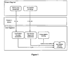
- the satellite system of the prior art consists of a ground segment and a user segment.
- the ground segment of the prior art consists of a SiS Accuracy assessment, which determines a signal in space accuracy (SiS_Acc), and a SiS real time monitoring, which determines a integrity flag (IF) and a signal in space monitoring accuracy (SiS_MA).
- the ground segment broadcasts the signal in space accuracy (SiS_Acc), the integrity flag (IF), and the signal in space monitoring accuracy (SiS_MA) through the space segment to the user segment.
- the user segment of the prior art consists of a user position accuracy assessment, a user position integrity risk assessment, and a critical satellite counting function.
- the user position accuracy assessment determines a user position accuracy (U_Acc) using the signal in space accuracy (U_Acc).
- the user position integrity risk assessment determines a user position integrity risk (U_Int). Further, the critical satellite counting function determines the number of critical satellites.
- the ground segment of a satellite system determines and broadcasts to he user (via possibly different communication medium) the expected performances of each satellite signal in space (SiS), including signal in space accuracy (SiS_Acc), signal in space continuity (SiS_Cont), signal in space static integrity (SiS_IntS) versus signal in space alert limit (SiS_AL) and signal in space monitoring accuracy (SiS_MA), signal in space dynamic integrity (SiS_IntD) versus a signal in space variation rate limit (SiS_VRL), signal in space monitoring accuracy (SiS_MA).
- SiS_Acc signal in space accuracy
- SiS_Cont signal in space continuity
- SiS_IntS signal in space alert limit
- SiS_MA signal in space monitoring accuracy
- SiS_MA signal in space dynamic integrity
- SiS_IntD signal in space dynamic integrity
- SiS_VRL signal in space monitoring accuracy
- SiS_MA signal in space monitoring accuracy
- In general medium refers to space segment or another satellite transmission system
- the user segment e.g. a user receiver will autonomously determine the user position performance comprising user position accuracy (U_Acc), user position continuity (U_Cont), and user position integrity (U_Int) versus user position alert limit (U_AL).
- the user segment will declare the service available.
- the ground component of the satellite system monitors in real time the residual error of each satellite signal (SiSE) with the signal in space monitoring accuracy (SIS_MA) and broadcasts a DON'T USE integrity flag (IF) if the estimated signal in space error (eSiSE) of a given satellite is beyond the signal in space alert limit (SiS_AL) or the estimated variation rate of the signal in space error is beyond the signal in space variation rate limit (SiS_VRL).
- IF DON'T USE integrity flag
- the system comprises three elements the ground segment, the broadcast process and the user segment.
- the ground segment monitors the satellite signal in space against accuracy, integrity and continuity criteria.
- the broadcast process provides signal in space performance characteristics to the user segment over a Space Segment, e.g. an arbitrary combination of a broadcast of signal performance process (B1) using the MEO constellation, a broadcast of signal performance process (B2) using the GEO satellite, and a broadcast of signal performance process (B3) using another broadcast medium (like Digital Audio Broadcast over terrestrial means), or another broadcast medium. It is especially disclosed that the information can be broadcast over any medium (MEO/GEO satellites or other terrestrial means).
- These signal in space performance characteristics include the integrity flag (IF), the applied signal in space alert limit (SiS_AL), the signal in space variation rate limit (SiS_VRL) and the ground segment signal in space monitoring accuracy (SiS_MA).
- the user segment uses the signal in space accuracy (SiS_Acc), the signal in space static and dynamic integrity risk (SiS_Int; SiS_IntS, SiS_IntD), the signal in space continuity risk (SiS_Cont), the integrity flag (IF), the signal in space alert limit (SiS_AL) and the signal in space variation rate limit (SiS_VRL) made available by the ground segment, to compute the user position accuracy (U_Acc), the user position integrity risk (U_Int), and the user position continuity risk (U_Cont).
- the SoL navigation service comprises the ground segment, the broadcast processes, and the user segment.
- the ground segment comprises a SiS accuracy assessment (A1), a SiS continuity risk assessement (A2), a SiS integrity risk assessment (A3), and a SiS real time monitoring (A4).
- the SiS accuracy assessment (A1) determines the signal in space accuracy (SiS_Acc).
- the SiS accuracy assessment (A1) comprises a regular assessment, for each satellite, of the signal in space accuracy (SiS_Acc). This assessment can be done e.g. by a computation of the standard deviation of the signal in space Error (SiSE) over a certain time frame. This computation can further be based on the pseudo range measurement collected from a network of reference receivers.
- the SiS accuracy assessment (A1) sends the signal in space accuracy (SiS_Acc) to the user position accuracy assessment (C1) of the User Segment.
- the SiS continuity risk assessment (A2) determines the signal in space continuity (SiS_Cont) based on history analysis and extrapolation method.
- the SiS continuity risk assessment (A2) comprises a regular assessment of the signal in space continuity (SiS_Cont) as defined above for each satellite of the considered satellite system.
- the assessment of the signal in space continuity (SiS_Cont) can be done for instance by a computation based on the statistical analysis of observed discontinuities of the signal in space Error (SiSE) and an extrapolation thereof. This computation can further be based on the pseudo range measurement collected from a network of reference receivers.
- the SiS continuity risk assessment (A2) sends the satellite signal continuity (SiS_Cont) to the user position continuity risk assessment (C2) of the User Segment.
- the SiS integrity risk assessment (A3) determines the signal in space static and dynamic integrity (SiS_Int; SiS_IntS, SiS_IntD).
- the SiS integrity risk assessment (A3) comprises a regular assessment of the signal in space static and dynamic integrity (SiS_Int; SiS_IntS, SiS_IntD) as defined above.
- the assessment of the signal in space static and dynamic integrity (SiS_Int; SiS_IntS, SiS_IntD) can be done for instance by a computation based on the statistical analysis of observed signal in space error (SiSE) anomalous ramps or brutal variations and extrapolation thereof. This computation can further be based on the pseudo range measurement collected from a network of reference receivers.
- the SiS integrity risk assessment (A3) sends the satellite signal integrity (SiS_Int; SiS_IntS, SiS_IntD) to the user position integrity risk assessment (C3) of the User Segment.
- the SiS real time monitoring (A4) determines the integrity flag (IF), the signal in space monitoring accuracy (SiS_MA), the signal in space alert limit (SiS_AL), and the signal in space variation rate limit (SiS_VRL).
- the SiS real time monitoring (A4) comprises a real time estimation, for each satellites, of the signal in space Error (SiSE) and signal in space Error variation rate (SiSEVR) and a real time check that the estimated signal in space error (eSiSE) does not exceed a threshold called signal in space alert limit (SiS_AL) and the signal in space estimated variation rate does not exceed a defined threshold called the signal in space variation rate limit (SiS_VRL).
- the estimation can be done for instance by a computation based on real time pseudo range measurement collected from a network of reference receivers.
- the accuracy of the measurement is provided to the user through signal in space monitoring accuracy value (SiS_MA).
- the SiS real time monitoring (A4) sends the integrity flag (IF), the signal in space monitoring accuracy (SiS_MA), the signal in space alert limit (SiS_AL), and the signal in space variation rate limit (SiS_VRL) to the user position accuracy assessment (C1), the user position continuity risk assessment (C2), and the user position integrity risk assessment (C3) of the User Segment.
- eSiSE real time estimated signal in space error
- SiS_AL signal in space alert limit
- eSiSEVR real time estimated signal in space variation rate limit
- IF Integrity Flag
- the broadcast processes comprise an arbitrary combination of a broadcast of signal performance process (B1) using the MEO constellation, a broadcast of signal performance process (B2) using the GEO satellite, and a broadcast of signal performance process (B3) using another broadcast medium (like Digital Audio Broadcast over terrestrial means).
- the combination of broadcast medium is determined by data rate requirement (e.g., the data rate necessary for the service), the reliability (continuity risk) requirement, the cost and the required efficiency.
- the broadcast processes comprise the broadcasting to the user the ground determined signal in space performance data including the signal in space accuracy (SiS_Acc), the signal in space continuity risk (SiS_Cont), the signal in space static and dynamic integrity risk (SiS_Int; SiS_IntS, SiS_IntD), the signal in space monitoring accuracy (SiS_MA), the signal in space alert limit (SiS_AL), the signal in space variation rate limit (SiS_VRL), and the integrity flag (IF) related to each satellite.
- This broadcast can go over different medium including the navigation satellite relaying these data to the user segments, e.g. user receivers.
- the user segment e.g. a user receiver, comprises a user position accuracy assessment (C1), a user position continuity risk assessment (C2), a user position integrity risk assessment (C3), and a user position real time monitoring (C4).
- C1 user position accuracy assessment
- C2 user position continuity risk assessment
- C3 user position integrity risk assessment
- C4 user position real time monitoring
- the user position accuracy assessment (C1) determines user position accuracy (U_Acc).
- the user position accuracy assessment (C1) determines the user position accuracy (U_Acc) taking as input the received signal in space accuracy (SiS_Acc) of the various satellites in view.
- the user accuracy determination is computed from the different SiS_Acc parameters, according to a statistical error model. In the current state of art, centered Gaussian model is used.
- the user position accuracy assessment (C1) sends the user position accuracy (U_Acc) to the user position real time monitoring (C4).
- the user position continuity risk assessment (C2) determines a user position continuity risk (U_Cont).
- the user position continuity risk assessment (C2) determines the user position continuity risk (U_Cont) considering among other input the received signal in space continuity risk (SiS_Cont) of the various satellites in view. Only the signal in space continuity risk SIS_Cont of critical satellites is to be considered in user continuity risk (U_Cont) computation. In the state of arts, critical satellites are counted and should be less than six for the service to be available.
- the user position continuity risk assessment (C2) sends the user position continuity risk (U_Cont) to the user position real time monitoring (C4).
- the user position integrity risk assessment (C3) determines a user position integrity risk (U_Int).
- the user position integrity risk assessment (C3) determines the user position integrity risk (U_Int) considering among other input the received signal in space accuracy (SiS_Acc), the received signal in space integrity risk (SiS_Int), the received signal in space alert limit (SiS_AL), the received signal in space monitoring accuracy (SiS_MA), the received signal in space variation rate limit (SiS_VRL) and the received time to alert (TTA) of the various satellites in view.
- the user integrity risk determination is computed from the different integrity parameters, according to a statistical error model. In the current state of art, centered and biased Gaussian model are used. After the assessment the user position integrity risk assessment (C3) sends the user position integrity risk (U_Int) to the user position real time monitoring (C4).
- the user position real time monitoring (C4) monitors in real time the following conditions: the user position accuracy (U_Acc) determined by the user position accuracy assessment (C1) is meeting the SoL service accuracy requirement, the user position continuity risk (U_Cont) determined by the user position continuity risk assessment (C2) is meeting the SoL service integrity requirement, and the user position integrity risk (U_Int) determined by the user position integrity risk assessment (C3) is meeting the SoL service continuity requirement.
- the user segment shall declare the SoL positioning service available if various conditions are met including the conditions just described.
- the invention defines the features to be implemented on the ground component of the satellite system and on the User segment of the satellite system so as to meet these Safety of Life performances in an efficient and certifiable manner.
- a ground segment (A1, A2, A3, A4) determines information (SiS_Acc, SiS_Cont, SiS_IntS, SiS_IntD, SiS_MA, SiS_AL, SiS_VRL, TTA) needed for a user position performance (U_Acc, U_Cont, U_Int).
- the ground segment (A1, A2, A3, A4) broadcasts the information (SiS_Acc, SiS_Cont, SiS_IntS, SiS_IntD, SiS_MA, SiS_AL, SiS_VRL, TTA) to a user segment (C1, C2, C3, C4).
- the user segment (C1, C2, C3, C4) autonomously determines the user position performance (U_Acc, U_Cont, U_Int).
- the process also comprises the step that the broadcast of the information (SiS_Acc, SiS_Cont, SiS_IntS, SiS_IntD, SiS_MA, SiS_AL, SiS_VRL, TTA) to the user segment (C1, C2, C3, C4) is done via a broadcast process as described above. Further details of the process result for those skilled in the art from the description of the satellite system above.
Landscapes
- Engineering & Computer Science (AREA)
- Radar, Positioning & Navigation (AREA)
- Remote Sensing (AREA)
- Computer Security & Cryptography (AREA)
- Computer Networks & Wireless Communication (AREA)
- Physics & Mathematics (AREA)
- General Physics & Mathematics (AREA)
- Position Fixing By Use Of Radio Waves (AREA)
Abstract
Description
- The invention relates to satellite systems that provide navigation services. Examples of such systems are generic Global Navigation Satellite Systems (GNSS) such as Medium Earth Orbit (MEO) constellation based system (like the American GPS, the Russian GLONASS or the European Galileo), and generic Satellite Based Augmentation Systems (SBAS) like for instance the European EGNOS, the American WAAS or the Japanese MSAS. However, these are only examples. The invention is not restricted to these systems. The invention can apply in all areas where navigation services are deemed to meet performance requirement including accuracy, integrity and continuity criteria or any combined subset of these criteria. It can apply in many GNSS application domain, including but not limited to the aviation domain, the telecommunication domain, the maritime domain, the power grid control domain, the terrestrial fleet management domain, the precision agriculture domain, the defense and homeland security domain, the intelligent transport systems and other GNSS application known in the art.
- For navigation services in aviation and other safety of life (SoL) domains, the service performances are defined in terms of user position accuracy (U_Acc), user position continuity (U_Cont) and user position integrity (U_Int) versus predefined alert limits (U_AL).
- According to the applicable aviation and other SoL standard requirements, the following definitions apply.
- The user position error (UE) refers to the difference between a measured or estimated position and the true position at any user location. The user position accuracy (U_Acc) refers to 0.95 percentile ("2-sigma") of user position error (UE) distribution model at a given user location.
- Further, the user position continuity risk (U_Cont) refers to the probability of having, in a coming bounded time interval, a discontinuity of the positioning service, e.g., a probability of 10-5 within a time interval of 15 seconds.
- Further, signal in space continuity risk (SiS_Cont) refers to the probability of having, in a coming bounded time interval, a discontinuity of the signal in space of a given Satellite, e.g., a probability of 3·10-6 within a time interval of 15 seconds. The discontinuity can be caused by various factors including signal broadcast interruption or integrity flag being raised by the ground against the considered satellite.
- Further, user position integrity risk (U_Int) refers to the probability of having, in a coming bounded time interval, a position error equal or beyond defined vertical/alert limits (U_AL), e.g., a probability of 10-7 within a time interval of 150 seconds.
- Further, signal in space integrity risk (SiS_Int) refers to the probability of having, at user level, in a coming bounded time interval and for a given satellite, a signal in space anomalous error, e.g., a probability of 10-6 within a time interval of 150 seconds. The signal in space integrity risk (SiS_Int) can materialize through various factors including on board clock instabilities, on board transponder path delay instabilities, unpredicted maneuver, ephemeris and clock errors, etc. The distribution of magnitude of unflagged signal in space feared event is over-bounded thanks to (SiS_Int) and to the defined signal in space Alert Limit (SiS_AL).
- Further, signal in space static integrity risk (SiS_IntS) refers to the probability of having, at user level, in a coming bounded time interval and for a given satellite, a signal in space anomalous error, with dynamic lower than SiS_VRL and no ground segment flag provision under the time to alert requirement conditions, e.g., a probability of 10-6 within a time interval of 150 seconds. The signal in space static integrity risk (SiS_IntS) can materialize through various factors including on board clock instabilities, on board transponder path delay instabilities, unpredicted maneuver, ephemeris and clock errors, etc. The distribution of magnitude of unflagged signal in space static feared event is over-bounded thanks to SiS_IntS and to the defined signal in space Alert Limit (SiS_AL).
- Further, signal in space dynamic integrity risk (SiS_IntD) refers to the probability of having, at user level, in a coming bounded time interval and for a given satellite, a signal in space anomalous error, with dynamic higher than SiS_VRL and no ground segment flag provision under the time to alert requirement conditions, e.g., a probability of 10-6 within a time interval of 150 seconds. The signal in space dynamic integrity risk (SiS_IntD) can materialize through various factors including on board clock instabilities, on board transponder path delay instabilities, unpredicted maneuver, ephemeris and clock errors etc. The magnitude of the signal in space feared event is over-bounded thanks to SiS_IntD, to the defined time to alert TTA and to the defined signal in space variation rate limit SiS_VRL.
- Especially, the navigation performance requirement for SoL services include user position accuracy (U_Acc), user position continuity (U_Cont) and user position integrity (U_Int) versus predefined vertical and horizontal alert limits (U_AL). At any given point in time and space, the navigation SoL service is declared available if only the user position accuracy (U_Acc), the user position continuity (U_Cont), and the user position integrity (U_Int) are below thresholds defined by the applicable SoL standard.
- Further, signal in space accuracy (SiS_Acc) refers to a quantity characterizing the spread of the signal in space error distribution in fault free mode.
- Further, signal in space monitoring accuracy (SiS_MA) refers to a quantity characterizing the spread of the signal in space monitoring error distribution. Combined with defined SiS_AL and SiS_Int/SiS_IntS, these quantities provide an over-bound of the signal in space error in failure mode.
- Further, signal in space alert limit (SiS_AL) refers to the estimated signal in space error limit above which the ground component of the satellite system provides integrity flag (IF). Combined with defined SiS_MA and SiS_Int/SiS_IntS, these quantities provide an over-bound of the signal in space error in failure mode/static failure mode.
- Further, signal in space variation rate limit (SiS_VRL) refers to the estimated signal in space error variation rate limit above which the ground component of the satellite system provides integrity flag (IF). Combined with defined SiS_IntD, SiS_MA and TTA, these quantities provide an over bound of the signal in space error in dynamic failure mode.
- In dynamic failure mode, the product SiS_VRL*TTA is the equivalent of defined quantity SiS_AL in static failure mode.
- Further, time to alert (TTA) refers to the maximum time delay between the appearance of an alert condition and the reception at user level of the subsequent integrity flag provided by the ground component of the satellite system.
- Further, estimated signal in space error (eSISE) refers to the ground component estimation of the signal in space error SISE.
- Further, estimated signal in space variation rate refers to the ground component estimation of the signal in space variation rate (eSISVR).
The prior art has the disadvantage that firstly it makes no distinction between static and dynamic failure modes (privation of easy detection of particular kind of failure (ramps, steps)) and secondly supposes all of the defined above quantities are hard-coded in user algorithms, except signal in space accuracy (SiS_Acc) and signal in space monitoring accuracy (SiS_MA). Hard-coded values have the disadvantage that the system is not adaptive to future evolution, that the system is not adaptive to receiver autonomous integrity monitoring facility, that the system is not adaptive to low satellites underperformances and that large margins are necessary inducing oversizing. - It is an object of the invention to provide a satellite system and a process capable of determining the integrity risk and the continuity risk at any user location.
- The problem is solved by a satellite system according to claim 1 and a process according to claim 4.
- It is an advantage of the present invention that the broadcast of all information necessary for risk calculation enables the system to be adaptive to future satellites performances evolution (no value should be hardcoded).
- It is a further advantage of the present invention that the broadcast of different information relevant to different classes of receiver (variable RAIM capabilities, i.e. capabilities referring to ramp detection, receiver coupled to inertial system, etc.) enables the service to be adaptive to user specificity.
- It is a further advantage of the present invention that the broadcast of all information necessary to risk calculation enables to reduce the margin which should have been taken with hard coded and thus to optimize the system.
- Fig. 1
- shows the satellite system according to the prior art
- Fig. 2
- shows the satellite system according to the invention
- A satellite system of the prior art is shown in Fig. 1. The satellite system of the prior art consists of a ground segment and a user segment. The ground segment of the prior art consists of a SiS Accuracy assessment, which determines a signal in space accuracy (SiS_Acc), and a SiS real time monitoring, which determines a integrity flag (IF) and a signal in space monitoring accuracy (SiS_MA). The ground segment broadcasts the signal in space accuracy (SiS_Acc), the integrity flag (IF), and the signal in space monitoring accuracy (SiS_MA) through the space segment to the user segment. The user segment of the prior art consists of a user position accuracy assessment, a user position integrity risk assessment, and a critical satellite counting function. The user position accuracy assessment determines a user position accuracy (U_Acc) using the signal in space accuracy (U_Acc). The user position integrity risk assessment determines a user position integrity risk (U_Int). Further, the critical satellite counting function determines the number of critical satellites.
- According to the invention the ground segment of a satellite system determines and broadcasts to he user (via possibly different communication medium) the expected performances of each satellite signal in space (SiS), including signal in space accuracy (SiS_Acc), signal in space continuity (SiS_Cont), signal in space static integrity (SiS_IntS) versus signal in space alert limit (SiS_AL) and signal in space monitoring accuracy (SiS_MA), signal in space dynamic integrity (SiS_IntD) versus a signal in space variation rate limit (SiS_VRL), signal in space monitoring accuracy (SiS_MA). In general medium refers to space segment or another satellite transmission system or ground transmission system (e.g. radio). Based on the signal in space accuracy (SiS_Acc), the signal in space continuity (SiS_Cont), the signal in space static integrity (SiS_IntS), the signal in space alert limit (SiS_AL), the signal in space monitoring accuracy (SiS_MA), signal in space dynamic integrity (SiSIntD), and signal in space variation rate limit (SiS_VRL) data received for each satellite in view, the user segment, e.g. a user receiver will autonomously determine the user position performance comprising user position accuracy (U_Acc), user position continuity (U_Cont), and user position integrity (U_Int) versus user position alert limit (U_AL).
- If the User position performance determined e.g. by the user segment is within the SoL performance requirement, the user segment will declare the service available.
- Parallel to the above process, and to guarantee the broadcast values signal in space accuracy (SiS_Acc), signal in space continuity (SiS_Cont), signal in space static integrity (SiS_IntS), signal in space alert limit (SiS_AL), signal in space monitoring accuracy (SiS_MA), signal in space dynamic integrity (SiS_IntD), and signal in space variation rate limit (SiS_VRL), the ground component of the satellite system monitors in real time the residual error of each satellite signal (SiSE) with the signal in space monitoring accuracy (SIS_MA) and broadcasts a DON'T USE integrity flag (IF) if the estimated signal in space error (eSiSE) of a given satellite is beyond the signal in space alert limit (SiS_AL) or the estimated variation rate of the signal in space error is beyond the signal in space variation rate limit (SiS_VRL).
- The invention is now described in greater detail. According to Fig. 2, the system comprises three elements the ground segment, the broadcast process and the user segment. The ground segment monitors the satellite signal in space against accuracy, integrity and continuity criteria. The broadcast process provides signal in space performance characteristics to the user segment over a Space Segment, e.g. an arbitrary combination of a broadcast of signal performance process (B1) using the MEO constellation, a broadcast of signal performance process (B2) using the GEO satellite, and a broadcast of signal performance process (B3) using another broadcast medium (like Digital Audio Broadcast over terrestrial means), or another broadcast medium. It is especially disclosed that the information can be broadcast over any medium (MEO/GEO satellites or other terrestrial means). These signal in space performance characteristics include the integrity flag (IF), the applied signal in space alert limit (SiS_AL), the signal in space variation rate limit (SiS_VRL) and the ground segment signal in space monitoring accuracy (SiS_MA). Further, the user segment uses the signal in space accuracy (SiS_Acc), the signal in space static and dynamic integrity risk (SiS_Int; SiS_IntS, SiS_IntD), the signal in space continuity risk (SiS_Cont), the integrity flag (IF), the signal in space alert limit (SiS_AL) and the signal in space variation rate limit (SiS_VRL) made available by the ground segment, to compute the user position accuracy (U_Acc), the user position integrity risk (U_Int), and the user position continuity risk (U_Cont).
- According to the invention the SoL navigation service, the implementation of the SoL navigation service comprises the ground segment, the broadcast processes, and the user segment.
- The ground segment comprises a SiS accuracy assessment (A1), a SiS continuity risk assessement (A2), a SiS integrity risk assessment (A3), and a SiS real time monitoring (A4).
- The SiS accuracy assessment (A1) determines the signal in space accuracy (SiS_Acc). The SiS accuracy assessment (A1) comprises a regular assessment, for each satellite, of the signal in space accuracy (SiS_Acc). This assessment can be done e.g. by a computation of the standard deviation of the signal in space Error (SiSE) over a certain time frame. This computation can further be based on the pseudo range measurement collected from a network of reference receivers. After the assessment, the SiS accuracy assessment (A1) sends the signal in space accuracy (SiS_Acc) to the user position accuracy assessment (C1) of the User Segment.
- The SiS continuity risk assessment (A2) determines the signal in space continuity (SiS_Cont) based on history analysis and extrapolation method. The SiS continuity risk assessment (A2) comprises a regular assessment of the signal in space continuity (SiS_Cont) as defined above for each satellite of the considered satellite system. The assessment of the signal in space continuity (SiS_Cont) can be done for instance by a computation based on the statistical analysis of observed discontinuities of the signal in space Error (SiSE) and an extrapolation thereof. This computation can further be based on the pseudo range measurement collected from a network of reference receivers. After the assessment, the SiS continuity risk assessment (A2) sends the satellite signal continuity (SiS_Cont) to the user position continuity risk assessment (C2) of the User Segment.
- The SiS integrity risk assessment (A3) determines the signal in space static and dynamic integrity (SiS_Int; SiS_IntS, SiS_IntD). The SiS integrity risk assessment (A3) comprises a regular assessment of the signal in space static and dynamic integrity (SiS_Int; SiS_IntS, SiS_IntD) as defined above. The assessment of the signal in space static and dynamic integrity (SiS_Int; SiS_IntS, SiS_IntD) can be done for instance by a computation based on the statistical analysis of observed signal in space error (SiSE) anomalous ramps or brutal variations and extrapolation thereof. This computation can further be based on the pseudo range measurement collected from a network of reference receivers. After the assessment, the SiS integrity risk assessment (A3) sends the satellite signal integrity (SiS_Int; SiS_IntS, SiS_IntD) to the user position integrity risk assessment (C3) of the User Segment.
- The SiS real time monitoring (A4) determines the integrity flag (IF), the signal in space monitoring accuracy (SiS_MA), the signal in space alert limit (SiS_AL), and the signal in space variation rate limit (SiS_VRL). The SiS real time monitoring (A4) comprises a real time estimation, for each satellites, of the signal in space Error (SiSE) and signal in space Error variation rate (SiSEVR) and a real time check that the estimated signal in space error (eSiSE) does not exceed a threshold called signal in space alert limit (SiS_AL) and the signal in space estimated variation rate does not exceed a defined threshold called the signal in space variation rate limit (SiS_VRL). The estimation can be done for instance by a computation based on real time pseudo range measurement collected from a network of reference receivers. The accuracy of the measurement is provided to the user through signal in space monitoring accuracy value (SiS_MA). After the assessment, the SiS real time monitoring (A4) sends the integrity flag (IF), the signal in space monitoring accuracy (SiS_MA), the signal in space alert limit (SiS_AL), and the signal in space variation rate limit (SiS_VRL) to the user position accuracy assessment (C1), the user position continuity risk assessment (C2), and the user position integrity risk assessment (C3) of the User Segment.
- If the real time estimated signal in space error (eSiSE) of a given satellite is beyond the signal in space alert limit (SiS_AL) or the real time estimated signal in space variation rate (eSiSEVR) is beyond the signal in space variation rate limit (SiS_VRL), an Integrity Flag (IF) is raised and broadcast to the user so that this satellite is excluded by the user from its input to position computation.
- The broadcast processes comprise an arbitrary combination of a broadcast of signal performance process (B1) using the MEO constellation, a broadcast of signal performance process (B2) using the GEO satellite, and a broadcast of signal performance process (B3) using another broadcast medium (like Digital Audio Broadcast over terrestrial means).
- The combination of broadcast medium is determined by data rate requirement (e.g., the data rate necessary for the service), the reliability (continuity risk) requirement, the cost and the required efficiency.
- The broadcast processes (B1, B2, B3) comprise the broadcasting to the user the ground determined signal in space performance data including the signal in space accuracy (SiS_Acc), the signal in space continuity risk (SiS_Cont), the signal in space static and dynamic integrity risk (SiS_Int; SiS_IntS, SiS_IntD), the signal in space monitoring accuracy (SiS_MA), the signal in space alert limit (SiS_AL), the signal in space variation rate limit (SiS_VRL), and the integrity flag (IF) related to each satellite. This broadcast can go over different medium including the navigation satellite relaying these data to the user segments, e.g. user receivers.
- The user segment, e.g. a user receiver, comprises a user position accuracy assessment (C1), a user position continuity risk assessment (C2), a user position integrity risk assessment (C3), and a user position real time monitoring (C4).
- The user position accuracy assessment (C1) determines user position accuracy (U_Acc). The user position accuracy assessment (C1) determines the user position accuracy (U_Acc) taking as input the received signal in space accuracy (SiS_Acc) of the various satellites in view. The user accuracy determination is computed from the different SiS_Acc parameters, according to a statistical error model. In the current state of art, centered Gaussian model is used. After the assessment, the user position accuracy assessment (C1) sends the user position accuracy (U_Acc) to the user position real time monitoring (C4).
- The user position continuity risk assessment (C2) determines a user position continuity risk (U_Cont). The user position continuity risk assessment (C2) determines the user position continuity risk (U_Cont) considering among other input the received signal in space continuity risk (SiS_Cont) of the various satellites in view. Only the signal in space continuity risk SIS_Cont of critical satellites is to be considered in user continuity risk (U_Cont) computation. In the state of arts, critical satellites are counted and should be less than six for the service to be available. After the assessment, the user position continuity risk assessment (C2) sends the user position continuity risk (U_Cont) to the user position real time monitoring (C4).
- The user position integrity risk assessment (C3) determines a user position integrity risk (U_Int). The user position integrity risk assessment (C3) determines the user position integrity risk (U_Int) considering among other input the received signal in space accuracy (SiS_Acc), the received signal in space integrity risk (SiS_Int), the received signal in space alert limit (SiS_AL), the received signal in space monitoring accuracy (SiS_MA), the received signal in space variation rate limit (SiS_VRL) and the received time to alert (TTA) of the various satellites in view. The user integrity risk determination is computed from the different integrity parameters, according to a statistical error model. In the current state of art, centered and biased Gaussian model are used. After the assessment the user position integrity risk assessment (C3) sends the user position integrity risk (U_Int) to the user position real time monitoring (C4).
- The user position real time monitoring (C4) monitors in real time the following conditions: the user position accuracy (U_Acc) determined by the user position accuracy assessment (C1) is meeting the SoL service accuracy requirement, the user position continuity risk (U_Cont) determined by the user position continuity risk assessment (C2) is meeting the SoL service integrity requirement, and the user position integrity risk (U_Int) determined by the user position integrity risk assessment (C3) is meeting the SoL service continuity requirement.
- The user segment shall declare the SoL positioning service available if various conditions are met including the conditions just described.
- The invention defines the features to be implemented on the ground component of the satellite system and on the User segment of the satellite system so as to meet these Safety of Life performances in an efficient and certifiable manner.
- It is further disclosed a process for determining an integrity risk and a continuity risk for a satellite system. In a first step of the process a ground segment (A1, A2, A3, A4) determines information (SiS_Acc, SiS_Cont, SiS_IntS, SiS_IntD, SiS_MA, SiS_AL, SiS_VRL, TTA) needed for a user position performance (U_Acc, U_Cont, U_Int). Next the ground segment (A1, A2, A3, A4) broadcasts the information (SiS_Acc, SiS_Cont, SiS_IntS, SiS_IntD, SiS_MA, SiS_AL, SiS_VRL, TTA) to a user segment (C1, C2, C3, C4). Then, the user segment (C1, C2, C3, C4) autonomously determines the user position performance (U_Acc, U_Cont, U_Int). The process also comprises the step that the broadcast of the information (SiS_Acc, SiS_Cont, SiS_IntS, SiS_IntD, SiS_MA, SiS_AL, SiS_VRL, TTA) to the user segment (C1, C2, C3, C4) is done via a broadcast process as described above. Further details of the process result for those skilled in the art from the description of the satellite system above.
Claims (8)
- Satellite system for providing a navigation service comprising a ground segment (A1, A2, A3, A4) and a user segment (C1, C2, C3, C4), characterized in that the ground segment (A1, A2, A3, A4) provides information (SiS_Acc, SiS_Cont, SiS_IntS, SiS_IntD, SiS_MA, SiS_AL, SiS_VRL, TTA) to enable the user segment (C1, C2, C3, C4) to autonomously determine the user position performance (U_Acc, U_Cont, U_Int).
- Satellite system according to claim 1 characterized in that the information (SiS_Acc, SiS_Cont, SiS_IntS, SiS_IntD, SiS_MA, SiS_AL, SiS_VRL, TTA) is broadcast to the user segment (C1, C2, C3, C4) via a broadcast process.
- Satellite system according to claim 2 characterized in that the broadcast process comprises a satellite or a terrestrial means or an arbitrary combination of satellites and terrestrial means for broadcasting the information (SiS_Acc, SiS_Cont, SiS_IntS, SiS_IntD, SiS_MA, SiS_AL, SiS_VRL, TTA) to the user segment (C1, C2, C3, C4).
- Satellite system according to one of the claims 1 to 3 characterized in that the ground segment (A1, A2, A3, A4) comprises a SiS continuity risk assessment (A2) determining a signal in space continuity (SiS_Cont) and/or a SiS integrity risk assessment (A3) determining a signal in space static integrity (SiS_IntS) and/or a signal in space dynamic integrity (SiS_IntD).
- Satellite system according to one of the claims 1 to 4 characterized in that the user segment (C1, C2, C3) comprises a user position continuity risk assessment (C2) determining a user position continuity risk (U_Cont).
- Satellite system according to one of the claims 1 to 5 characterized in that the information (SiS_Acc, SiS_Cont, SiS_IntS, SiS_IntD, SiS_MA, SiS_AL, SiS_VRL, TTA) comprises at least one of the parameters signal in space accuracy (SiS_Acc), signal in space continuity (SiS_Cont), signal in space static integrity (SiS_IntS), signal in space dynamic integrity (SiS_IntD), signal in space monitoring accuracy (SiS_MA), signal in space alert limit (SiS_AL), time to alert (TTA) and/or signal in space variation rate limit (SiS_VRL).
- Satellite system according to one of the claims 1 to 6 characterized in that the user position performance (U_Acc, U_Cont, U_Int) comprises at least one of the parameters user position continuity risk (U_Cont), and/or user position integrity risk (U_Int).
- Process for determining an integrity risk and a continuity risk for a satellite system comprising the steps of
a ground segment (A1, A2, A3, A4) determines information (SiS_Acc, SiS_Cont, SiS_IntS, SiS_IntD, SiS_MA, SiS_AL, SiS_VRL, TTA) needed for a user position performance (U_Acc, U_Cont, U_Int),
the ground segment (A1, A2, A3, A4) broadcasts the information (SiS_Acc, SiS_Cont, SiS_IntS, SiS_IntD, SiS_MA, SiS_AL, SiS_VRL, TTA) to a user segment (C1, C2, C3, C4), and
the user segment (C1, C2, C3, C4) autonomously determines the user position performance (U_Acc, U_Cont, U_Int).
Priority Applications (2)
| Application Number | Priority Date | Filing Date | Title |
|---|---|---|---|
| EP06005846.8A EP1837673B1 (en) | 2006-03-22 | 2006-03-22 | Apparatus and process for a global navigation satellite system meeting safety of live performance requirements |
| US11/723,704 US7576691B2 (en) | 2006-03-22 | 2007-03-21 | Apparatus and process for a global navigation satellite system meeting safety of life performance requirements |
Applications Claiming Priority (1)
| Application Number | Priority Date | Filing Date | Title |
|---|---|---|---|
| EP06005846.8A EP1837673B1 (en) | 2006-03-22 | 2006-03-22 | Apparatus and process for a global navigation satellite system meeting safety of live performance requirements |
Publications (2)
| Publication Number | Publication Date |
|---|---|
| EP1837673A1 true EP1837673A1 (en) | 2007-09-26 |
| EP1837673B1 EP1837673B1 (en) | 2015-10-14 |
Family
ID=36931555
Family Applications (1)
| Application Number | Title | Priority Date | Filing Date |
|---|---|---|---|
| EP06005846.8A Expired - Lifetime EP1837673B1 (en) | 2006-03-22 | 2006-03-22 | Apparatus and process for a global navigation satellite system meeting safety of live performance requirements |
Country Status (2)
| Country | Link |
|---|---|
| US (1) | US7576691B2 (en) |
| EP (1) | EP1837673B1 (en) |
Families Citing this family (7)
| Publication number | Priority date | Publication date | Assignee | Title |
|---|---|---|---|---|
| DE102008037174B4 (en) * | 2008-08-11 | 2011-07-07 | Astrium GmbH, 82024 | Method and device for optimizing the accuracy of the position determination and / or for reducing the integrity risk of a receiver in a global navigation satellite system |
| EP2169417B1 (en) * | 2008-09-29 | 2012-10-31 | Astrium GmbH | Method and device method for detecting frequency jumps of a navigation satellite's master clock |
| DE102010004617A1 (en) * | 2010-01-13 | 2011-07-14 | Astrium GmbH, 82024 | Improvement of integrity communication in a satellite navigation system |
| DE102010007700A1 (en) * | 2010-02-10 | 2011-08-11 | Astrium GmbH, 82024 | Method for enhancement of integrity communication in mobile navigation device, involves receiving and evaluating information for distribution of clock synchronization errors while observation precision is measured based on information |
| ITTO20110686A1 (en) * | 2011-07-28 | 2013-01-29 | Sisvel Technology Srl | METHOD TO GUARANTEE THE CONTINUITY OF SERVICE OF A PERSONAL NAVIGATION AND RELATIVE DEVICE |
| CN103596126A (en) * | 2012-08-15 | 2014-02-19 | 中兴通讯股份有限公司 | Personalized enhancement service method, network side device, and mobile user device |
| CN114114345B (en) * | 2022-01-27 | 2022-05-13 | 航天宏图信息技术股份有限公司 | Big data-based Beidou RNSS intelligent operation and maintenance method |
Citations (1)
| Publication number | Priority date | Publication date | Assignee | Title |
|---|---|---|---|---|
| US20040088111A1 (en) | 2002-11-01 | 2004-05-06 | Honeywell International Inc. | Apparatus for improved integrity of wide area differential satellite navigation systems |
Family Cites Families (10)
| Publication number | Priority date | Publication date | Assignee | Title |
|---|---|---|---|---|
| US5650770A (en) * | 1994-10-27 | 1997-07-22 | Schlager; Dan | Self-locating remote monitoring systems |
| US7085637B2 (en) * | 1997-10-22 | 2006-08-01 | Intelligent Technologies International, Inc. | Method and system for controlling a vehicle |
| WO1998043372A1 (en) * | 1997-03-21 | 1998-10-01 | The Board Of Trustees Of The Leland Stanford Junior University | A system using leo satellites for centimeter-level navigation |
| US6639541B1 (en) * | 2000-08-29 | 2003-10-28 | The United States Of America As Represented By The Secretary Of The Navy | Device and method for detecting, measuring, and reporting low-level interference at a receiver |
| AU2002334708A1 (en) * | 2001-10-01 | 2003-04-14 | Kline And Walker, Llc | Pfn/trac system faa upgrades for accountable remote and robotics control |
| US7164383B2 (en) * | 2002-09-25 | 2007-01-16 | The Board Of Regents Of The University Of Oklahoma | Navigation system using locally augmented GPS |
| US20050018795A1 (en) * | 2003-05-30 | 2005-01-27 | Cmc Electronics Inc. | Low cost, high integrity digital signal processing |
| WO2004111675A1 (en) * | 2003-06-13 | 2004-12-23 | Harvey A Stephen | Security system including a method and system for acquiring gps satellite position |
| US20060047413A1 (en) * | 2003-12-02 | 2006-03-02 | Lopez Nestor Z | GNSS navigation solution integrity in non-controlled environments |
| US7548196B2 (en) * | 2005-02-15 | 2009-06-16 | Fagan John E | Navigation system using external monitoring |
-
2006
- 2006-03-22 EP EP06005846.8A patent/EP1837673B1/en not_active Expired - Lifetime
-
2007
- 2007-03-21 US US11/723,704 patent/US7576691B2/en not_active Expired - Fee Related
Patent Citations (1)
| Publication number | Priority date | Publication date | Assignee | Title |
|---|---|---|---|---|
| US20040088111A1 (en) | 2002-11-01 | 2004-05-06 | Honeywell International Inc. | Apparatus for improved integrity of wide area differential satellite navigation systems |
Non-Patent Citations (3)
| Title |
|---|
| J. FERNOW, D. O'LAUGHLIN: "Estimating Continuity of GNSS", ION GPS/GNSS PROCEEDINGS, 21 September 2004 (2004-09-21) - 24 September 2004 (2004-09-24), US, pages 2113 - 2123, XP002397833 * |
| OEHLER V ET AL: "The Galileo Integrity Concept", INTERNATIONAL TECHNICAL MEETING OF THE SATELLITE DIVISION OF THE INSTITUTE OF NAVIGATION, WASHINGTON, DC, US, 21 September 2004 (2004-09-21), pages 604 - 615, XP002375520 * |
| P. OBER, R. FARNWORTH, E. BREEUWER, D. VAN WILLIGEN: "SBAS Integrity Verification", ION GPS/GNSS PROCEEDINGS, 11 September 2001 (2001-09-11), US, pages 1805 - 1830, XP002397832 * |
Also Published As
| Publication number | Publication date |
|---|---|
| EP1837673B1 (en) | 2015-10-14 |
| US7576691B2 (en) | 2009-08-18 |
| US20070285310A1 (en) | 2007-12-13 |
Similar Documents
| Publication | Publication Date | Title |
|---|---|---|
| Du et al. | Vulnerabilities and integrity of precise point positioning for intelligent transport systems: Overview and analysis | |
| EP3627188B1 (en) | Correction information integrity monitoring in navigation satellite system positioning methods, systems, and devices | |
| Hewitson et al. | GNSS receiver autonomous integrity monitoring (RAIM) performance analysis | |
| US10295674B2 (en) | System and method for determining protection level | |
| US7576691B2 (en) | Apparatus and process for a global navigation satellite system meeting safety of life performance requirements | |
| US20100033370A1 (en) | Gnss navigation solution integrity in non-controlled environments | |
| US9921314B2 (en) | Using code minus carrier measurements to mitigate spatial decorrelation errors caused by ionosphere delays | |
| CN108490459B (en) | Method and system for applying precision and risk balance to GNSS position service | |
| EP2648018B1 (en) | An improved RAIM algorithm | |
| CN104732085A (en) | Satellite navigation satellite-based augmentation system availability prediction method | |
| Blanch et al. | Architectures for advanced RAIM: Offline and online | |
| El-Mowafy | Pilot evaluation of integrating GLONASS, Galileo and BeiDou with GPS in ARAIM | |
| Blanch et al. | Position error bound calculation for GNSS using measurement residuals | |
| Tang et al. | Ephemeris type A fault analysis and mitigation for LAAS | |
| Walter et al. | Future architectures to provide aviation integrity | |
| Khanafseh et al. | ARAIM integrity support message parameter validation by online ground monitoring | |
| CN113625308A (en) | Method and system for detecting satellite space signal abnormity | |
| Van Dyke et al. | GPS integrity failure modes and effects analysis | |
| CN113740885A (en) | Base station and satellite fault simulation system based on network differential positioning service | |
| Blanch et al. | A clock and ephemeris algorithm for dual frequency SBAS | |
| Blanch et al. | Advanced RAIM system architecture with a long latency integrity support message | |
| US20120274511A1 (en) | Satellite Based Augmentation System | |
| US10514463B2 (en) | Ground-based system and method to monitor for excessive delay gradients using long reference receiver separation distances | |
| Magdaleno et al. | SBAS Guidelines for Shipborne Receiver and EGNOS Performances based on IMO Res. A. 1046 (27) | |
| Pirazzi et al. | A GNSS integrity monitoring station with Software Defined Radio and low cost receivers |
Legal Events
| Date | Code | Title | Description |
|---|---|---|---|
| PUAI | Public reference made under article 153(3) epc to a published international application that has entered the european phase |
Free format text: ORIGINAL CODE: 0009012 |
|
| AK | Designated contracting states |
Kind code of ref document: A1 Designated state(s): AT BE BG CH CY CZ DE DK EE ES FI FR GB GR HU IE IS IT LI LT LU LV MC NL PL PT RO SE SI SK TR |
|
| AX | Request for extension of the european patent |
Extension state: AL BA HR MK YU |
|
| 17P | Request for examination filed |
Effective date: 20080225 |
|
| 17Q | First examination report despatched |
Effective date: 20080407 |
|
| AKX | Designation fees paid |
Designated state(s): DE FR GB IT |
|
| REG | Reference to a national code |
Ref country code: DE Ref legal event code: R079 Ref document number: 602006046903 Country of ref document: DE Free format text: PREVIOUS MAIN CLASS: G01S0001000000 Ipc: G01S0019200000 |
|
| GRAP | Despatch of communication of intention to grant a patent |
Free format text: ORIGINAL CODE: EPIDOSNIGR1 |
|
| RIC1 | Information provided on ipc code assigned before grant |
Ipc: G01S 19/08 20100101ALI20150415BHEP Ipc: G01S 19/20 20100101AFI20150415BHEP |
|
| INTG | Intention to grant announced |
Effective date: 20150504 |
|
| RIN1 | Information on inventor provided before grant (corrected) |
Inventor name: BOUTTEAU, BERTRAND Inventor name: TRAUTENBERG, DR. HANS L. Inventor name: FAVIN-LEVEQUE, HUGUES |
|
| RAP1 | Party data changed (applicant data changed or rights of an application transferred) |
Owner name: AIRBUS DS GMBH |
|
| GRAS | Grant fee paid |
Free format text: ORIGINAL CODE: EPIDOSNIGR3 |
|
| GRAA | (expected) grant |
Free format text: ORIGINAL CODE: 0009210 |
|
| AK | Designated contracting states |
Kind code of ref document: B1 Designated state(s): DE FR GB IT |
|
| REG | Reference to a national code |
Ref country code: GB Ref legal event code: FG4D |
|
| REG | Reference to a national code |
Ref country code: DE Ref legal event code: R096 Ref document number: 602006046903 Country of ref document: DE |
|
| REG | Reference to a national code |
Ref country code: FR Ref legal event code: PLFP Year of fee payment: 11 |
|
| PGFP | Annual fee paid to national office [announced via postgrant information from national office to epo] |
Ref country code: GB Payment date: 20160321 Year of fee payment: 11 Ref country code: FR Payment date: 20160321 Year of fee payment: 11 |
|
| REG | Reference to a national code |
Ref country code: DE Ref legal event code: R097 Ref document number: 602006046903 Country of ref document: DE |
|
| PGFP | Annual fee paid to national office [announced via postgrant information from national office to epo] |
Ref country code: DE Payment date: 20160330 Year of fee payment: 11 |
|
| PLBE | No opposition filed within time limit |
Free format text: ORIGINAL CODE: 0009261 |
|
| STAA | Information on the status of an ep patent application or granted ep patent |
Free format text: STATUS: NO OPPOSITION FILED WITHIN TIME LIMIT |
|
| PGFP | Annual fee paid to national office [announced via postgrant information from national office to epo] |
Ref country code: IT Payment date: 20160324 Year of fee payment: 11 |
|
| 26N | No opposition filed |
Effective date: 20160715 |
|
| REG | Reference to a national code |
Ref country code: DE Ref legal event code: R119 Ref document number: 602006046903 Country of ref document: DE |
|
| GBPC | Gb: european patent ceased through non-payment of renewal fee |
Effective date: 20170322 |
|
| REG | Reference to a national code |
Ref country code: FR Ref legal event code: ST Effective date: 20171130 |
|
| PG25 | Lapsed in a contracting state [announced via postgrant information from national office to epo] |
Ref country code: DE Free format text: LAPSE BECAUSE OF NON-PAYMENT OF DUE FEES Effective date: 20171003 Ref country code: FR Free format text: LAPSE BECAUSE OF NON-PAYMENT OF DUE FEES Effective date: 20170331 |
|
| PG25 | Lapsed in a contracting state [announced via postgrant information from national office to epo] |
Ref country code: GB Free format text: LAPSE BECAUSE OF NON-PAYMENT OF DUE FEES Effective date: 20170322 Ref country code: IT Free format text: LAPSE BECAUSE OF NON-PAYMENT OF DUE FEES Effective date: 20170322 |