EP1832844A1 - Navigation system - Google Patents
Navigation system Download PDFInfo
- Publication number
- EP1832844A1 EP1832844A1 EP07103827A EP07103827A EP1832844A1 EP 1832844 A1 EP1832844 A1 EP 1832844A1 EP 07103827 A EP07103827 A EP 07103827A EP 07103827 A EP07103827 A EP 07103827A EP 1832844 A1 EP1832844 A1 EP 1832844A1
- Authority
- EP
- European Patent Office
- Prior art keywords
- lane
- vehicle
- traffic
- distance
- climbing
- Prior art date
- Legal status (The legal status is an assumption and is not a legal conclusion. Google has not performed a legal analysis and makes no representation as to the accuracy of the status listed.)
- Granted
Links
Images


Classifications
-
- G—PHYSICS
- G01—MEASURING; TESTING
- G01C—MEASURING DISTANCES, LEVELS OR BEARINGS; SURVEYING; NAVIGATION; GYROSCOPIC INSTRUMENTS; PHOTOGRAMMETRY OR VIDEOGRAMMETRY
- G01C21/00—Navigation; Navigational instruments not provided for in groups G01C1/00 - G01C19/00
- G01C21/26—Navigation; Navigational instruments not provided for in groups G01C1/00 - G01C19/00 specially adapted for navigation in a road network
- G01C21/34—Route searching; Route guidance
- G01C21/36—Input/output arrangements for on-board computers
- G01C21/3626—Details of the output of route guidance instructions
- G01C21/3658—Lane guidance
-
- G—PHYSICS
- G08—SIGNALLING
- G08G—TRAFFIC CONTROL SYSTEMS
- G08G1/00—Traffic control systems for road vehicles
- G08G1/09—Arrangements for giving variable traffic instructions
- G08G1/0962—Arrangements for giving variable traffic instructions having an indicator mounted inside the vehicle, e.g. giving voice messages
- G08G1/0968—Systems involving transmission of navigation instructions to the vehicle
- G08G1/096805—Systems involving transmission of navigation instructions to the vehicle where the transmitted instructions are used to compute a route
- G08G1/096811—Systems involving transmission of navigation instructions to the vehicle where the transmitted instructions are used to compute a route where the route is computed offboard
-
- G—PHYSICS
- G08—SIGNALLING
- G08G—TRAFFIC CONTROL SYSTEMS
- G08G1/00—Traffic control systems for road vehicles
- G08G1/09—Arrangements for giving variable traffic instructions
- G08G1/0962—Arrangements for giving variable traffic instructions having an indicator mounted inside the vehicle, e.g. giving voice messages
- G08G1/0968—Systems involving transmission of navigation instructions to the vehicle
- G08G1/096855—Systems involving transmission of navigation instructions to the vehicle where the output is provided in a suitable form to the driver
- G08G1/096861—Systems involving transmission of navigation instructions to the vehicle where the output is provided in a suitable form to the driver where the immediate route instructions are output to the driver, e.g. arrow signs for next turn
-
- B—PERFORMING OPERATIONS; TRANSPORTING
- B60—VEHICLES IN GENERAL
- B60W—CONJOINT CONTROL OF VEHICLE SUB-UNITS OF DIFFERENT TYPE OR DIFFERENT FUNCTION; CONTROL SYSTEMS SPECIALLY ADAPTED FOR HYBRID VEHICLES; ROAD VEHICLE DRIVE CONTROL SYSTEMS FOR PURPOSES NOT RELATED TO THE CONTROL OF A PARTICULAR SUB-UNIT
- B60W30/00—Purposes of road vehicle drive control systems not related to the control of a particular sub-unit, e.g. of systems using conjoint control of vehicle sub-units, or advanced driver assistance systems for ensuring comfort, stability and safety or drive control systems for propelling or retarding the vehicle
- B60W30/10—Path keeping
- B60W30/12—Lane keeping
-
- B—PERFORMING OPERATIONS; TRANSPORTING
- B60—VEHICLES IN GENERAL
- B60W—CONJOINT CONTROL OF VEHICLE SUB-UNITS OF DIFFERENT TYPE OR DIFFERENT FUNCTION; CONTROL SYSTEMS SPECIALLY ADAPTED FOR HYBRID VEHICLES; ROAD VEHICLE DRIVE CONTROL SYSTEMS FOR PURPOSES NOT RELATED TO THE CONTROL OF A PARTICULAR SUB-UNIT
- B60W50/00—Details of control systems for road vehicle drive control not related to the control of a particular sub-unit, e.g. process diagnostic or vehicle driver interfaces
- B60W50/08—Interaction between the driver and the control system
- B60W50/14—Means for informing the driver, warning the driver or prompting a driver intervention
Definitions
- the present invention relates to a navigation system for providing guidance when needed regarding traffic lanes when a passing lane, a climbing lane, or a lane for slower traffic becomes within a predetermined distance and, in particular, for improving ease of driving for a driver.
- Such a navigation apparatus detects a current position of the vehicle by means of a GPS receiver, obtains map data corresponding to the current position through a data storage medium such as a DVD-ROM or an HDD, or a network, and displays the map on an LCD monitor.
- the navigation apparatus provides traffic guidance when the vehicle with the navigation apparatus approaches an intersection, a passing lane, a climbing lane, or a lane for slower traffic and the guidance supports the driver so that the driver can drive comfortably.
- a navigation apparatus disclosed in the patent document Japanese Unexamined Patent Application Publication No.
- 2002-341758 provides advance traffic lane information to a driver by means of images and/or audio guidance when there is traffic lane information that the driver should be made aware of such as information about a climbing lane or a passing lane according to a route to a searched destination.
- the navigation apparatus disclosed in the patent document provides guidance regarding traffic lanes every time the vehicle approaches a climbing lane or a passing lane on the basis of the vehicle position data and map data.
- the driver does not need such guidance regarding traffic lanes, depending on the situation in which the vehicle travels. For example, it is unnecessary to provide guidance regarding traffic lanes such as a passing lane, a climbing lane, or a lane for slower traffic when heavy traffic is present because the driver cannot change traffic lanes. It is also unnecessary to provide guidance regarding traffic lanes when there is no vehicle other than the driver's vehicle because the driver's vehicle may not obstruct traffic or there is no vehicle to obstruct the driver's vehicle, that is, the driver does not have to change traffic lanes. If the navigation apparatus keeps providing guidance regarding traffic lanes whatever the situation is, it might cause the driver to lose concentration. In fact, some users think that unnecessary guidance is bothersome.
- a navigation system (1) comprising: a map data storage device (22) for storing map data including a roadway network; a vehicle position detecting device (12) for detecting a current vehicle position of a vehicle; an approach detecting device (11) for detecting whether the vehicle has approached a passing lane, a climbing lane, or a lane for slower traffic within a predetermined distance on the basis of the current vehicle position detected by the vehicle position detecting device and map data; and a traffic lane guidance device (14, 16) for providing guidance regarding the passing lane, the climbing lane, or the lane for slower traffic, provided that the approach detecting device has detected the vehicle has approached the passing lane, the climbing lane, or the lane for slower traffic within the predetermined distance, and: a distance detecting device (3, 4) for detecting a distance to another vehicle near the vehicle, wherein: the traffic lane guidance device provides guidance regarding the traffic lane on the basis of the distance detected by the distance detecting device
- a navigation system (1) comprising: a map data storage device (22) for storing map data including a roadway network; a vehicle position detecting device (12) for detecting a current vehicle position of a vehicle; an approach detecting device (11) for detecting whether the vehicle has approached a passing lane, a climbing lane, or a lane for slower traffic within a predetermined distance on the basis of the current vehicle position detected by the vehicle position detecting device and map data; and a traffic lane guidance device (14, 16) for providing guidance regarding the passing lane, the climbing lane, or the lane for slower traffic, provided that the approach detecting device has detected that the vehicle has approached the passing lane, the climbing lane, or the lane for slower traffic within the predetermined distance, and: a vehicle speed detecting device (5) for detecting a vehicle speed, wherein: the traffic lane guidance device provides guidance regarding the traffic lane on the basis of the vehicle speed detected by the vehicle speed detecting device.
- a vehicle speed detecting device (5) for detecting a vehicle speed
- the traffic lane guidance device (14, 16) provides guidance regarding the traffic lane on the basis of the distance detected by the distance detecting device (3, 4) and the vehicle speed detected by the vehicle speed detecting device (5).
- a leading distance determining device (11) for determining whether a leading distance to a vehicle to the rear of the vehicle is within a predetermined distance on the basis of the result of the detection performed by the distance detecting device (3, 4), wherein: the traffic lane guidance device (14, 16) provides guidance regarding a climbing lane or a lane for slower traffic, provided that the leading distance determining device determines that the leading distance is equal to or less than a predetermined distance.
- the navigation system (1) comprising: a following distance determining device (11) for determining whether a following distance to a vehicle ahead of the vehicle is within a predetermined distance on the basis of the result of the detection performed by the distance detecting device (3, 4), wherein: the traffic lane guidance device (14, 16) provides guidance regarding a passing lane, provided that the distance determining device determines that the distance is equal to or less than a predetermined distance.
- Various exemplary implementations of the principles described herein provide the navigation system (1), further comprising: a congestion information obtaining device (17) for obtaining congestion information, wherein: the traffic lane guidance device (14, 16) provides guidance regarding the traffic lane on the basis of congestion information obtained by the congestion information obtaining device.
- a congestion determining device (11) for determining whether a link in which the vehicle is currently traveling is congested on the basis of congestion information obtained by the congestion information obtaining device (17), wherein: the traffic lane guidance device (14, 16) does not provide guidance regarding a passing lane, a climbing lane, or a lane for slower traffic even if the approach detecting device (11) detects that the vehicle has approached the passing lane, the climbing lane, or the lane for slower traffic within a predetermined distance, provided that the congestion determining device determines that the link in which the vehicle is currently traveling is congested.
- a navigation system (1) comprising: a map data storage device (22) for storing map data including a roadway network; a vehicle position detecting device (12) for detecting a current vehicle position of a vehicle; an approach detecting device (11) for detecting whether the vehicle has approached a passing lane, a climbing lane, or a lane for slower traffic within a predetermined distance on the basis of the current vehicle position detected by the vehicle position detecting device and map data; and a traffic lane guidance device for providing guidance regarding the passing lane, the climbing lane, or the lane for slower traffic, provided that the approach detecting device has detected that the vehicle has approached the passing lane, the climbing lane, or the lane for slower traffic within the predetermined distance, and: a congestion information obtaining device (17) for obtaining congestion information, wherein: the traffic lane guidance device (14, 16) provides guidance regarding the traffic lane on the basis of congestion information obtained by the congestion information obtaining device.
- the navigation system when a vehicle approaches a passing lane, a climbing lane, or a lane for slower traffic within a predetermined distance, the navigation system detects distances between the vehicle and other vehicles near the vehicle and provides guidance regarding traffic lane on the basis of the detected distances. Therefore, it may be possible to provide guidance regarding traffic lane when needed on the basis of positional relationships of vehicles around the vehicle. No guidance is provided when the vehicle does not need guidance regarding traffic lane, so that a driver of the vehicle may drive without increasing his/her level of distraction and it may reduce the data processing burden related to guidance on the navigation system.
- the navigation system detects a vehicle speed when a vehicle approaches a passing lane, a climbing lane, or a lane for slower traffic within a predetermined distance, and provides guidance regarding the traffic lane on the basis of the detected vehicle speed. Therefore, it may be possible to provide guidance regarding traffic lane when needed on the basis of speed relationships of vehicles around the vehicle. No guidance is provided when the vehicle does not need guidance regarding traffic lane, so that the driver of the vehicle may drive without increasing his/her level of distraction.
- the navigation system detects following/leading distances and speeds of vehicles around the vehicle when a vehicle approaches a passing lane, a climbing lane, or a lane for slower traffic within a predetermined distance, and provides guidance regarding traffic lane on the basis of the detected following/leading distances and the vehicle speeds. Therefore, it may be possible to provide guidance regarding traffic lane when needed on the basis of position relationships and speed relationships of vehicles around the vehicle. No guidance is provided when the vehicle does not need guidance regarding traffic lane, so that the driver of the vehicle may drive without increasing his/her level of distraction.
- the navigation system provides guidance regarding a climbing lane or a lane for slower traffic when it is determined that the leading distance to the vehicle in the rear of the vehicle is equal to or less than a predetermined distance.
- the navigation system may provide guidance. As a result, it may increase convenience of the user.
- the navigation system provides guidance regarding a passing lane when it is determined that the following distance to the vehicle ahead of the vehicle is equal to or less than a predetermined distance.
- the navigation system may provide guidance. As a result, it may increase convenience of the user.
- the navigation system obtains congestion information when a vehicle approaches a passing lane, a climbing lane, or a lane for slower traffic within a predetermined distance, and provides guidance regarding traffic lane on the basis of the detected distances and the vehicle speeds as well as the obtained congestion information. Therefore, it may be possible to provide guidance regarding traffic lane when needed on the basis of the congestion on a link in which the vehicle is currently traveling. No guidance is provided when the vehicle does not need guidance regarding traffic lane, so that the driver of the vehicle may drive without increasing his/her level of distraction.
- the navigation system When it is determined that the link on which the vehicle is currently traveling is congested, the navigation system does not provide guidance regarding traffic lane even if the vehicle has approached a passing lane, a climbing lane, or a lane for slower traffic within a predetermined distance. No guidance is provided when the vehicle does not need guidance regarding traffic lane such as when the driver can not change traffic lanes, so that a driver of the vehicle may drive without increasing his/her level of distraction and it may reduce the data processing burden related to guidance on the navigation system.
- the navigation system obtains congestion information when a vehicle approaches a passing lane, a climbing lane, or a lane for slower traffic within a predetermined distance, and provides guidance regarding traffic lane on the basis of the obtained congestion information. Therefore, it may be possible to provide guidance regarding traffic lane when needed on the basis of the congestion on the link in which the vehicle is currently traveling. No guidance is provided when the vehicle does not need guidance regarding traffic lane, so that the driver of the vehicle may drive without increasing his/her level of distraction.
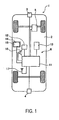
- FIG. 1 is a diagram showing a structure outline of a navigation system according to the current embodiment of the invention.
- FIG. 2 is a block diagram showing a frame format of a control system in the navigation system according to the current embodiment of the invention.
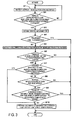
- FIG. 3 is a flowchart showing a first traffic lane guidance processing program according to the current embodiment of the invention.
- FIG. 4 is a diagram showing a frame format of a position relationships between a vehicle which is traveling from a main line to a climbing lane and vehicles which are traveling around the vehicle at a given time.
- FIG. 5 is a flowchart showing a second traffic lane guidance processing program according to the current embodiment of the invention.
- FIG. 6 is a diagram showing a frame format of a position relationships between a vehicle which is traveling from a main line to a passing lane and vehicles which are traveling around the vehicle at a given time.
- FIG. 1 is a diagram showing the structural outline of the navigation system 1 according to the current embodiment.
- FIG. 2 is a block diagram showing a control system of the navigation system 1 according to the current embodiment.
- the navigation system 1 of the current embodiment may include a front radar device (following distance detecting means) 3, a rear radar device (leading distance detecting means) 4, a vehicle speed sensor (vehicle speed detecting means) 5, and a navigation apparatus 6 mounted on a vehicle 2.
- the navigation apparatus 6 may further include a navigation ECU (approach detecting means, leading distance determining means, following distance determining means, congestion determining means) 11, a current position detecting section (vehicle position detecting means) 12, a data storage section (map data storage means) 13, an LCD display (traffic lane guidance means) 14, a touch panel 15, a speaker (traffic lane guidance means) 16, and a communication device (congestion information obtaining means) 17.
- the front radar device 3 is attached at the center of the upper side of a front car registration plate on the vehicle 2 and may include a radio wave transmitter and a radio wave receiver.
- the radio wave transmitter radiates a radio wave to in front of the vehicle 2 and the radio wave reflected off an object in front of the vehicle 2 (more specifically, another vehicle) is received by the radio wave receiver.
- the radio wave receiver As a result, it may be possible to detect a distance between the vehicle 2 and a vehicle ahead and a relative speed on the basis of the strength and wavelength of the reflected wave.
- the rear radar device 4 is attached at the center of the upper side of a rear car registration plate on the vehicle 2 and may include a radio wave transmitter and a radio wave receiver as in the case of the front radar device 3.
- the radio wave transmitter radiates a radio wave from the rear of the vehicle 2 and the radio wave reflected off an object to the rear of the vehicle 2 (more specifically, another vehicle) is received by the radio wave receiver.
- the radio wave receiver As a result, it may be possible to detect a distance between the vehicle 2 and a vehicle behind and a relative speed on the basis of the strength and wavelength of the reflected wave.
- the vehicle speed sensor 5 is a sensor for detecting a travel distance of the vehicle or the vehicle speed.
- the vehicle speed sensor 5 produces a pulse according to a rotation of wheels of the vehicle 2 and outputs the pulse signal to the navigation ECU 11.
- the navigation ECU 11 calculates the rotational speed of the wheels and the travel distance by counting the produced pulses.
- the current position detecting section 12 may include a GPS 31, a geomagnetic sensor 32, a distance sensor 33, a steering sensor 34, a gyro sensor 35 as a direction detecting section, and an altimeter (not shown), and may detect a position, a direction, and/or a distance to an object (for example, an intersection) in relation to the current vehicle 2.
- the GPS 31 detects a current vehicle position of the vehicle 2 and a current time by receiving an electric wave provided by a satellite
- the geomagnetic sensor 32 detects a vehicle direction on the basis of measuring the earth's magnetic field
- the distance sensor 33 detects a distance between predetermined points on a road.
- the distance sensor 33 a sensor for measuring a rotational speed of vehicle wheels (not shown) and detecting a distance on the basis of the rotational speed or another sensor for measuring an acceleration, integrating the acceleration twice, and determining the distance may be used.
- the steering sensor 34 detects a steering angle of the vehicle.
- a steering angle of the vehicle For example, an optical rotation sensor or a rotation resistance sensor attached on a rotating part of a steering wheel (not shown), or an angle sensor attached to a wheel may be used as the steering sensor 34.
- the gyro sensor 35 detects an angle of traverse of the vehicle.
- a gas-rate gyro or a vibration gyro may be used as the gyro sensor 35.
- the direction of the vehicle may be detected by integrating the angle of traverse detected by the gyro sensor 35.
- the data storage section 13 may include a hard disk (not shown) as an external storage device and as a storage medium, a map information DB 22 and a link statistics DB 23 which are stored in the hard disk, and a storage head (not shown) as a driver for reading out a predetermined program or for writing predetermined data on the hard disk.
- the hard disk is used as the external storage device and the storage media of the data storage section 13.
- a magnetic disk such as a flexible disk may be used as the external storage device instead.
- a memory card, a magnetic tape, a magnetic drum, a CD, an MD, a DVD, an optical disc, an MO, an IC card, or an optical card may be used as the external storage device as well.
- the map information DB 22 and the link statistics DB 23 will be described in detail later.
- the navigation ECU (Electronic Control Unit) 11 may include a CPU 41 as a calculating device and a control device for controlling the entire navigation apparatus 6, a RAM 42 for being used as a working memory when the CPU 41 executes various types of calculations and for storing route data according to a searched route, a ROM 43 for storing a control program, a first traffic lane guidance processing program (FIG. 3), and a second traffic lane guidance processing program (FIG. 5), and an internal storage device such as a flash memory 44 for storing a program read out from the ROM 43.
- the first traffic lane guidance processing program is a program for providing guidance regarding traffic lanes, provided that predetermined conditions are met when the vehicle approaches a climbing lane or a lane for slower traffic within a predetermined distance.
- the second traffic lane guidance processing program is a program for providing guidance regarding traffic lanes, provided that predetermined conditions are met when the vehicle approaches a passing lane within a predetermined distance.
- a semiconductor memory or a magnetic core memory may be used as the RAM 42, the ROM 43, or the flash memory 44.
- an MPU may be used as the calculating device and the control device instead of the CPU 41.
- various programs are stored in the ROM 43 and various data is stored in the data storage section 13.
- programs and data may be read out from the same external storage device or a memory card and may be written on the flash memory 44, so that the programs and data may be updated by replacing the memory card.
- the LCD display 14 is display means for displaying, for example, an operation guidance, an operation menu, a key guidance, a route from a current position to a destination, guidance information along the route, traffic information, news, a weather report, date and time, mails, and/or TV programs.
- characters and/or symbols for providing guidance regarding a traffic lane when the vehicle approaches a passing lane, a climbing lane, or a lane for slower traffic within a predetermined distance may be displayed on the LCD display 14.
- a CRT display, a plasma display, or a hologram device for projecting hologram images on a windshield of the vehicle may be used instead of the LCD display 14.
- the touch panel 15 is attached on the front side of the LCD display 14.
- the coordinates of the point where the user touched are specified and it may be determined where the user touched and what points the user touched after the initially touched point on the touch panel on the basis of the detected coordinates.
- a keyboard, a mouse, a remote control device, a joystick, a light pen, or a stylus pen may be used instead of the touch panel 15.
- the speaker 16 outputs an audio guidance for a traveling route on the basis of the direction supplied from the navigation ECU 11.
- the audio guidance may be "Please turn right at XX intersection 300 m ahead.” or "The climbing lane is coming up.”
- an audio guidance regarding a traffic lane is output when the vehicle approaches a passing lane, a climbing lane, or a lane for slower traffic within a predetermined distance.
- the audio guidance output from the speaker 16 may be not only a synthetic sound but various types of sound effects or various guidance information prerecorded on a tape or a memory.
- the communication device 17 is a beacon receiver for receiving traffic information, for example, congestion information, regulation information, parking area information, and traffic accident information transferred from a traffic information center such as VICS (®: Vehicle Information and Communication System) as an electric wave or an optical wave through an electric wave beacon device or an optical wave beacon device which is located along roads.
- a network device for communicating through a network such as an LAN, a WAN, an intranet, a mobile phone line network, a telephone line network, a public communication network, a private communication network, or the Internet may be used.
- the communication device 17 may include an FM receiver, so that not only information from the information center but also FM broadcast information such as news and a weather report may be received as an FM broadcast through an FM broadcast station.
- the beacon receiver and the FM receiver may be unitized and mounted as a VICS receiver. However, the beacon receiver and the FM receiver may be mounted individually if needed.
- map information DB 22 stored in the data storage section 13 map data needed for route guidance and a map display is stored.
- map display data for displaying a map, intersection data, link data 24 regarding roads (road links), node data 25 regarding node points, search data for searching for a route, facility data regarding facilities, and/or detection data for detecting points may be included in the map information DB 22.
- the data regarding road links may include data indicating a width of a road formed by links, a grade, a cant, a bank, a condition of a road surface, the number of traffic lanes, a point where the number of traffic lanes decreases, a point where a road becomes narrow, and/or a crossing place.
- the data regarding corner may include data indicating a curvature radius, an intersection, a T-shaped intersection, and/or a start/end point of a corner.
- the data regarding road attribute may include data indicating a passing lane, a climbing lane, and a lane for slower traffic.
- the data regarding road type may include data indicating a national road, a prefectural road, a narrow street, a highway, an urban highway, a tollway, and/or a toll bridge. Further, according to such tollways, data regarding an entrance/exit of the tollways (a ramp way) and a tollbooth (an interchange) may be included.
- link data for traffic lanes data indicating a starting/ending point of a passing lane, a climbing lane, or a lane for slower traffic may be stored.
- node data 25 coordinates (position) of a node point such as a fork in a road (including an intersection and a T-shaped intersection) or points which are set on a road at intervals of a predetermined distance depending on a curvature radius of the road, a node attribute indicating whether a node is on an intersection, a connected link number list for listing link IDs of links which are connected to nodes, an adjoining node number list for listing node numbers of adjoining nodes of a link, and/or a height of a node point (altitude) may be stored.
- a node point such as a fork in a road (including an intersection and a T-shaped intersection) or points which are set on a road at intervals of a predetermined distance depending on a curvature radius of the road, a node attribute indicating whether a node is on an intersection, a connected link number list for listing link IDs of links which are connected to nodes, an adjoining node number list for listing node numbers
- Search data is used for searching for a route to a set destination and displaying the route.
- search data may include route display data for displaying a travel time necessary for passing through a link and a route selected by a route search on an LCD display 14.
- Cost data may also be included in search data.
- Cost data is used for calculating a search cost such as a cost necessary for passing through a node (hereinafter referred to as node cost) and a cost for a link forming a road (hereinafter referred to as link cost).
- Node cost is basically set for a node at an intersection.
- a value of a node cost is determined on the basis of, for example, an existence or nonexistence of a traffic light, a travel direction of the vehicle when the vehicle passes through an intersection (that is, a right/left turn at the intersection).
- Link cost is determined on the basis of data regarding a road attribute, a road type, a width of a road, the number of traffic lanes on a link, and/or a length of a link.
- facility data data regarding, for example, a hotel, a hospital, a gas station, a parking area, a sightseeing facility, an interchange, a restaurant, and a service area in various areas is stored in association with facility IDs to specify such facilities.
- audio output data to output certain information from the speaker 16 of the navigation apparatus 6 is stored in the map information DB 22.
- the navigation apparatus 6 searches for a route from both sides, that is, from a starting point and from a destination, along links and nodes in map data.
- the search cost (the node cost and the link cost) accumulated from the starting point is added to the search cost accumulated from the destination point, that is, the total cost of the route is calculated. Then a route with the minimum total cost is set as the route for which guidance is to be given.
- the link statistics DB 23 is a DB in which map data such as an average link travel time, an average vehicle speed, and/or a congestion degree of a link is stored.
- the navigation ECU 11 calculates a travel time necessary for traveling to a set destination and a predicted arrival time at the destination on the basis of the average link travel time stored in the link statistics DB 23 and provides guidance.
- the navigation ECU 11 further coordinates link costs for route searching on the basis of the congestion degree.
- the navigation system 1 before guidance regarding a climbing lane or a lane for slower traffic is provided, the navigation system 1 compares the vehicle speed of the vehicle with the average vehicle speed on a link and determines whether the guidance regarding a traffic lane should be provided (S8 in FIG. 3) .
- Data in the map information DB 22 and the link statistics DB 23 may be updated when information is transferred from a storage medium such as a DVD and/or an external device, for example, a memory card, or when information is downloaded from a specified information center through the communication device 17.
- FIG. 3 is a flowchart showing the first traffic lane guidance processing program of the current embodiment.
- the first traffic lane guidance processing program is executed at predetermined intervals (for example, at 4 m intervals) after the ignition switch of the vehicle is turned on.
- the program is for providing guidance regarding a traffic lane when the vehicle approaches a climbing lane or a lane for slower traffic within a predetermined distance, provided that certain conditions are met.
- the program described in flowcharts of FIGs. 3 and 5 is stored in the RAM 42 or the ROM 43 of the navigation apparatus 6 and is executed by the CPU 41.
- the CPU 41 detects the current vehicle position and the travel direction by means of the current position detecting section 12 in Step 1 (hereinafter referred to as S1) and further detects the vehicle speed by counting pulses output from the vehicle speed sensor 5.
- the CPU 41 determines whether the vehicle has approached a start point of a climbing lane or a lane for slower traffic within a predetermined distance (500 m in the current embodiment) on the basis of map data stored in the map information DB 22. Note that, the processing in S1 and S2 is equal to the processing executed by the approach detecting means.
- FIG. 4 is a diagram showing a positional relationship between a vehicle 61, which is traveling from a main lane 51 to a climbing lane 52, and other vehicles 62 through 65, which are traveling around the vehicle 61, at a given time.
- a distance A between the starting point of the climbing lane 52 and the vehicle 61 is equal to or less than a predetermined distance (500 m in the current embodiment).
- the CPU 41 obtains traffic information from, for example, the traffic information center through the communication device 17 in S3.
- traffic information obtained in S3 may include congestion information, in particular, for specifying a congestion condition of a link.
- the CPU 41 determines whether a link in which the vehicle is currently traveling is congested on the basis of traffic information obtained in S3.
- the processing in S4 is equal to the processing executed by the congestion determining means.
- the procedure goes to S5.
- the following distance and the relative speed to the vehicle ahead are detected on the basis of the detection by the front radar device 3 and the leading distance from and the relative speed to the vehicle behind are detected on the basis of the detection by the rear radar device 4. More specifically, according to FIG. 4, the following distances or leading distance and the relative speeds for both of the vehicle ahead 62 and the vehicle behind 63 are detected in S5.
- the CPU 41 determines whether another vehicle is located to the rear of the vehicle within a predetermined distance (within 100 m in the current embodiment) on the basis of the result of the detection in S5. More specifically, in FIG. 4, it is determined whether the leading distance B between the vehicle 61 and the vehicle behind 63 is equal to or less than a predetermined distance (100 m in the current embodiment).
- the CPU 41 provides guidance regarding the climbing lane or the lane for slower traffic (S10). More specifically, an audio guidance such as "a climbing lane (the lane for slower traffic) is coming up" is output from the speaker 16 and characters or a symbol indicating the approach of the climbing lane or the lane for slower traffic is displayed on the LCD display 14. The user may easily recognize the approach of the climbing lane or the lane for slower traffic.
- the CPU 41 determines whether another vehicle is located in front of the vehicle within a predetermined distance (in the current embodiment, within 100 m) on the basis of the result of the detection in S5 and further determines whether the speed of the vehicle in front of the vehicle is equal to or less than the vehicle speed. More specifically, in FIG. 4, it is determined whether a following distance C between the vehicle ahead 62 and the vehicle 61 is equal to or less than a predetermined distance (in the current embodiment, 100 m) and whether the vehicle speed V2 of the vehicle ahead 62 is equal to or less than the vehicle speed V1 of the vehicle 61.
- the first traffic lane guidance processing program is terminated without providing guidance regarding a traffic lane.
- the CPU 41 provides guidance regarding the climbing lane or the lane for slower traffic to the user (S10) .
- FIG. 5 is a flowchart showing the second traffic lane guidance processing program according to the current embodiment.
- the second traffic lane guidance processing program is executed at predetermined intervals (for example, at 4 m intervals) after the ignition switch of the vehicle is turned on and provides guidance regarding a traffic lane if the vehicle approaches a passing lane within a predetermined distance and if certain conditions met.
- the CPU 41 detects the current vehicle position and the travel direction by the current position detecting section 12 in S11 and further detects the vehicle speed by counting pulses output from the vehicle speed sensor 5.
- the CPU 41 determines whether the vehicle has approached a start point of a passing lane within a predetermined distance (500 m in the current embodiment) on the basis of the current vehicle position detected in S11 and map data stored in the map information DB 22. Note that, the processing in S11 and S12 is equal to the processing by the approach detecting means.
- FIG. 6 is a diagram showing a frame format of a position relationship between a vehicle 81, which is traveling from a main lane 71 to a passing lane 72, and other vehicles 82 through 85, which are traveling around the vehicle 81, at a given time.
- a distance D between the starting point of the passing lane 72 and the vehicle 81 is equal to or less than a predetermined distance (500 m in the current embodiment).
- the CPU 41 obtains traffic information from, for example, the traffic information center through the communication device 17 in S13.
- traffic information obtained in S13 may include congestion information especially for specifying a congestion condition of a link.
- the CPU 41 determines whether a link on which the vehicle is currently traveling is congested on the basis of traffic information obtained in S13.
- the procedure goes to S15.
- the following distance and the relative speed to the vehicle ahead are detected on the basis of the detection by the front radar device 3. More specifically, according to FIG. 6, the following distance and the relative speed to the vehicle 82 which is in front of the vehicle 81 are detected in S15.
- the CPU 41 determines whether another vehicle is located in front of the vehicle within a predetermined distance (within 100 m in the current embodiment) on the basis of the result of the detection in S15. More specifically, in FIG. 6, it is determined whether the following distance E between the vehicle 81 and the vehicle ahead 82 is equal to or less than a predetermined distance (100 m in the current embodiment).
- the second traffic lane guidance processing program is terminated without providing guidance regarding traffic lane.
- the CPU 41 provides guidance regarding the passing lane (S19). More specifically, an audio guidance such as "the passing lane is coming up” is output from the speaker 16 and characters or a symbol indicating the approach of the passing lane is displayed on the LCD display 14. The user may easily recognize the approach of the passing lane.
- the CPU 41 provides guidance regarding the passing lane to the user (S19).
- the second traffic lane guidance processing program is terminated without providing guidance regarding traffic lane.
- the navigation system 1 detects a distance to another vehicle near the vehicle and/or the relative speed to the vehicle (S5).
- S10 guidance regarding the climbing lane or the lane for slower traffic is provided (S10).
- the navigation system 1 detects distances and relative speeds to vehicles around the vehicle (S5).
- the front radar device 3 and the rear radar device 4 detect following/leading distances to a vehicle ahead or to a vehicle behind and relative speeds to such vehicles.
- a camera for imaging an area surrounding the vehicle may be attached on the vehicle and it may be possible to detect following/leading distances and/or relative speeds on the basis of images obtained by the camera. It may also be possible to detect following/leading distances and/or relative speeds by communicating with vehicles each other.
- a navigation system detects, provided that a vehicle approaches a climbing lane or a lane for slower traffic within a predetermined distance, a distance to another vehicle near the vehicle and a relative speed to the vehicle, and further provided that a distance between the vehicle and a vehicle in the rear of the vehicle is shorter than a predetermined distance or that a distance between the vehicle and a vehicle ahead is shorter than a predetermined distance and the speed of the vehicle ahead is faster than the vehicle speed, the navigation system provides guidance regarding the climbing lane or the lane for slower traffic.
Abstract
Description
- The present invention relates to a navigation system for providing guidance when needed regarding traffic lanes when a passing lane, a climbing lane, or a lane for slower traffic becomes within a predetermined distance and, in particular, for improving ease of driving for a driver.
- In recent years, navigation apparatuses for enabling a driver of a vehicle to easily navigate to a destination have become very popular. Such a navigation apparatus detects a current position of the vehicle by means of a GPS receiver, obtains map data corresponding to the current position through a data storage medium such as a DVD-ROM or an HDD, or a network, and displays the map on an LCD monitor. The navigation apparatus provides traffic guidance when the vehicle with the navigation apparatus approaches an intersection, a passing lane, a climbing lane, or a lane for slower traffic and the guidance supports the driver so that the driver can drive comfortably. For example, a navigation apparatus disclosed in the patent document (
Japanese Unexamined Patent Application Publication No. 2002-341758 - The navigation apparatus disclosed in the patent document provides guidance regarding traffic lanes every time the vehicle approaches a climbing lane or a passing lane on the basis of the vehicle position data and map data. However, there are times the driver does not need such guidance regarding traffic lanes, depending on the situation in which the vehicle travels. For example, it is unnecessary to provide guidance regarding traffic lanes such as a passing lane, a climbing lane, or a lane for slower traffic when heavy traffic is present because the driver cannot change traffic lanes. It is also unnecessary to provide guidance regarding traffic lanes when there is no vehicle other than the driver's vehicle because the driver's vehicle may not obstruct traffic or there is no vehicle to obstruct the driver's vehicle, that is, the driver does not have to change traffic lanes. If the navigation apparatus keeps providing guidance regarding traffic lanes whatever the situation is, it might cause the driver to lose concentration. In fact, some users think that unnecessary guidance is bothersome.
- Accordingly, it is an object for the present invention to provide a navigation system for providing guidance regarding a passing lane, a climbing lane, or a lane for slower traffic when needed and for improving convenience of a user.
- To solve the problems described above, various exemplary implementations of the principles described herein provide a navigation system (1), comprising: a map data storage device (22) for storing map data including a roadway network; a vehicle position detecting device (12) for detecting a current vehicle position of a vehicle; an approach detecting device (11) for detecting whether the vehicle has approached a passing lane, a climbing lane, or a lane for slower traffic within a predetermined distance on the basis of the current vehicle position detected by the vehicle position detecting device and map data; and a traffic lane guidance device (14, 16) for providing guidance regarding the passing lane, the climbing lane, or the lane for slower traffic, provided that the approach detecting device has detected the vehicle has approached the passing lane, the climbing lane, or the lane for slower traffic within the predetermined distance, and: a distance detecting device (3, 4) for detecting a distance to another vehicle near the vehicle, wherein: the traffic lane guidance device provides guidance regarding the traffic lane on the basis of the distance detected by the distance detecting device.
- Various exemplary implementations of the principles described herein provide a navigation system (1), comprising: a map data storage device (22) for storing map data including a roadway network; a vehicle position detecting device (12) for detecting a current vehicle position of a vehicle; an approach detecting device (11) for detecting whether the vehicle has approached a passing lane, a climbing lane, or a lane for slower traffic within a predetermined distance on the basis of the current vehicle position detected by the vehicle position detecting device and map data; and a traffic lane guidance device (14, 16) for providing guidance regarding the passing lane, the climbing lane, or the lane for slower traffic, provided that the approach detecting device has detected that the vehicle has approached the passing lane, the climbing lane, or the lane for slower traffic within the predetermined distance, and: a vehicle speed detecting device (5) for detecting a vehicle speed, wherein: the traffic lane guidance device provides guidance regarding the traffic lane on the basis of the vehicle speed detected by the vehicle speed detecting device.
- Various exemplary implementations of the principles described herein provide the navigation system (1), further comprising: a vehicle speed detecting device (5) for detecting a vehicle speed, wherein: the traffic lane guidance device (14, 16) provides guidance regarding the traffic lane on the basis of the distance detected by the distance detecting device (3, 4) and the vehicle speed detected by the vehicle speed detecting device (5).
- Various exemplary implementations of the principles described herein provide the navigation system (1), further comprising: a leading distance determining device (11) for determining whether a leading distance to a vehicle to the rear of the vehicle is within a predetermined distance on the basis of the result of the detection performed by the distance detecting device (3, 4), wherein: the traffic lane guidance device (14, 16) provides guidance regarding a climbing lane or a lane for slower traffic, provided that the leading distance determining device determines that the leading distance is equal to or less than a predetermined distance.
- Various exemplary implementations of the principles described herein provide the navigation system (1), comprising: a following distance determining device (11) for determining whether a following distance to a vehicle ahead of the vehicle is within a predetermined distance on the basis of the result of the detection performed by the distance detecting device (3, 4), wherein: the traffic lane guidance device (14, 16) provides guidance regarding a passing lane, provided that the distance determining device determines that the distance is equal to or less than a predetermined distance.
- Various exemplary implementations of the principles described herein provide the navigation system (1), further comprising: a congestion information obtaining device (17) for obtaining congestion information, wherein: the traffic lane guidance device (14, 16) provides guidance regarding the traffic lane on the basis of congestion information obtained by the congestion information obtaining device.
- Various exemplary implementations of the principles described herein provide the navigation system (1), further comprising: a congestion determining device (11) for determining whether a link in which the vehicle is currently traveling is congested on the basis of congestion information obtained by the congestion information obtaining device (17), wherein: the traffic lane guidance device (14, 16) does not provide guidance regarding a passing lane, a climbing lane, or a lane for slower traffic even if the approach detecting device (11) detects that the vehicle has approached the passing lane, the climbing lane, or the lane for slower traffic within a predetermined distance, provided that the congestion determining device determines that the link in which the vehicle is currently traveling is congested.
- Various exemplary implementations of the principles described herein provide a navigation system (1), comprising: a map data storage device (22) for storing map data including a roadway network; a vehicle position detecting device (12) for detecting a current vehicle position of a vehicle; an approach detecting device (11) for detecting whether the vehicle has approached a passing lane, a climbing lane, or a lane for slower traffic within a predetermined distance on the basis of the current vehicle position detected by the vehicle position detecting device and map data; and a traffic lane guidance device for providing guidance regarding the passing lane, the climbing lane, or the lane for slower traffic, provided that the approach detecting device has detected that the vehicle has approached the passing lane, the climbing lane, or the lane for slower traffic within the predetermined distance, and: a congestion information obtaining device (17) for obtaining congestion information, wherein: the traffic lane guidance device (14, 16) provides guidance regarding the traffic lane on the basis of congestion information obtained by the congestion information obtaining device.
- According to the navigation system with the structure described above, when a vehicle approaches a passing lane, a climbing lane, or a lane for slower traffic within a predetermined distance, the navigation system detects distances between the vehicle and other vehicles near the vehicle and provides guidance regarding traffic lane on the basis of the detected distances. Therefore, it may be possible to provide guidance regarding traffic lane when needed on the basis of positional relationships of vehicles around the vehicle. No guidance is provided when the vehicle does not need guidance regarding traffic lane, so that a driver of the vehicle may drive without increasing his/her level of distraction and it may reduce the data processing burden related to guidance on the navigation system.
- The navigation system detects a vehicle speed when a vehicle approaches a passing lane, a climbing lane, or a lane for slower traffic within a predetermined distance, and provides guidance regarding the traffic lane on the basis of the detected vehicle speed. Therefore, it may be possible to provide guidance regarding traffic lane when needed on the basis of speed relationships of vehicles around the vehicle. No guidance is provided when the vehicle does not need guidance regarding traffic lane, so that the driver of the vehicle may drive without increasing his/her level of distraction.
- The navigation system detects following/leading distances and speeds of vehicles around the vehicle when a vehicle approaches a passing lane, a climbing lane, or a lane for slower traffic within a predetermined distance, and provides guidance regarding traffic lane on the basis of the detected following/leading distances and the vehicle speeds. Therefore, it may be possible to provide guidance regarding traffic lane when needed on the basis of position relationships and speed relationships of vehicles around the vehicle. No guidance is provided when the vehicle does not need guidance regarding traffic lane, so that the driver of the vehicle may drive without increasing his/her level of distraction.
- The navigation system provides guidance regarding a climbing lane or a lane for slower traffic when it is determined that the leading distance to the vehicle in the rear of the vehicle is equal to or less than a predetermined distance. When the vehicle should change the traveling traffic lane to the climbing lane or the lane for slower traffic not to obstruct the vehicle behind, the navigation system may provide guidance. As a result, it may increase convenience of the user.
- The navigation system provides guidance regarding a passing lane when it is determined that the following distance to the vehicle ahead of the vehicle is equal to or less than a predetermined distance. When the vehicle should change the traveling traffic lane to the passing lane not to be obstructed by the vehicle ahead of the vehicle, the navigation system may provide guidance. As a result, it may increase convenience of the user.
- The navigation system obtains congestion information when a vehicle approaches a passing lane, a climbing lane, or a lane for slower traffic within a predetermined distance, and provides guidance regarding traffic lane on the basis of the detected distances and the vehicle speeds as well as the obtained congestion information. Therefore, it may be possible to provide guidance regarding traffic lane when needed on the basis of the congestion on a link in which the vehicle is currently traveling. No guidance is provided when the vehicle does not need guidance regarding traffic lane, so that the driver of the vehicle may drive without increasing his/her level of distraction.
- When it is determined that the link on which the vehicle is currently traveling is congested, the navigation system does not provide guidance regarding traffic lane even if the vehicle has approached a passing lane, a climbing lane, or a lane for slower traffic within a predetermined distance. No guidance is provided when the vehicle does not need guidance regarding traffic lane such as when the driver can not change traffic lanes, so that a driver of the vehicle may drive without increasing his/her level of distraction and it may reduce the data processing burden related to guidance on the navigation system.
- The navigation system obtains congestion information when a vehicle approaches a passing lane, a climbing lane, or a lane for slower traffic within a predetermined distance, and provides guidance regarding traffic lane on the basis of the obtained congestion information. Therefore, it may be possible to provide guidance regarding traffic lane when needed on the basis of the congestion on the link in which the vehicle is currently traveling. No guidance is provided when the vehicle does not need guidance regarding traffic lane, so that the driver of the vehicle may drive without increasing his/her level of distraction.
- FIG. 1 is a diagram showing a structure outline of a navigation system according to the current embodiment of the invention.
- FIG. 2 is a block diagram showing a frame format of a control system in the navigation system according to the current embodiment of the invention.
- FIG. 3 is a flowchart showing a first traffic lane guidance processing program according to the current embodiment of the invention.
- FIG. 4 is a diagram showing a frame format of a position relationships between a vehicle which is traveling from a main line to a climbing lane and vehicles which are traveling around the vehicle at a given time.
- FIG. 5 is a flowchart showing a second traffic lane guidance processing program according to the current embodiment of the invention.
- FIG. 6 is a diagram showing a frame format of a position relationships between a vehicle which is traveling from a main line to a passing lane and vehicles which are traveling around the vehicle at a given time.
- A navigation system according to an embodiment of the present invention is described below with reference to the attached figures.
- First, a structural outline of a
navigation system 1 according to the current embodiment is described with reference to FIGs. 1 and 2. FIG. 1 is a diagram showing the structural outline of thenavigation system 1 according to the current embodiment. FIG. 2 is a block diagram showing a control system of thenavigation system 1 according to the current embodiment. - As shown in FIGs. 1 and 2, the
navigation system 1 of the current embodiment may include a front radar device (following distance detecting means) 3, a rear radar device (leading distance detecting means) 4, a vehicle speed sensor (vehicle speed detecting means) 5, and anavigation apparatus 6 mounted on avehicle 2. Thenavigation apparatus 6 may further include a navigation ECU (approach detecting means, leading distance determining means, following distance determining means, congestion determining means) 11, a current position detecting section (vehicle position detecting means) 12, a data storage section (map data storage means) 13, an LCD display (traffic lane guidance means) 14, atouch panel 15, a speaker (traffic lane guidance means) 16, and a communication device (congestion information obtaining means) 17. - The
front radar device 3 is attached at the center of the upper side of a front car registration plate on thevehicle 2 and may include a radio wave transmitter and a radio wave receiver. The radio wave transmitter radiates a radio wave to in front of thevehicle 2 and the radio wave reflected off an object in front of the vehicle 2 (more specifically, another vehicle) is received by the radio wave receiver. As a result, it may be possible to detect a distance between thevehicle 2 and a vehicle ahead and a relative speed on the basis of the strength and wavelength of the reflected wave. - The
rear radar device 4 is attached at the center of the upper side of a rear car registration plate on thevehicle 2 and may include a radio wave transmitter and a radio wave receiver as in the case of thefront radar device 3. The radio wave transmitter radiates a radio wave from the rear of thevehicle 2 and the radio wave reflected off an object to the rear of the vehicle 2 (more specifically, another vehicle) is received by the radio wave receiver. As a result, it may be possible to detect a distance between thevehicle 2 and a vehicle behind and a relative speed on the basis of the strength and wavelength of the reflected wave. - The
vehicle speed sensor 5 is a sensor for detecting a travel distance of the vehicle or the vehicle speed. Thevehicle speed sensor 5 produces a pulse according to a rotation of wheels of thevehicle 2 and outputs the pulse signal to thenavigation ECU 11. The navigation ECU 11 calculates the rotational speed of the wheels and the travel distance by counting the produced pulses. - Next, each element of the
navigation apparatus 6 will be described. The currentposition detecting section 12 may include aGPS 31, ageomagnetic sensor 32, adistance sensor 33, asteering sensor 34, agyro sensor 35 as a direction detecting section, and an altimeter (not shown), and may detect a position, a direction, and/or a distance to an object (for example, an intersection) in relation to thecurrent vehicle 2. - More specifically, the
GPS 31 detects a current vehicle position of thevehicle 2 and a current time by receiving an electric wave provided by a satellite, thegeomagnetic sensor 32 detects a vehicle direction on the basis of measuring the earth's magnetic field, and thedistance sensor 33 detects a distance between predetermined points on a road. For example, as thedistance sensor 33, a sensor for measuring a rotational speed of vehicle wheels (not shown) and detecting a distance on the basis of the rotational speed or another sensor for measuring an acceleration, integrating the acceleration twice, and determining the distance may be used. - The
steering sensor 34 detects a steering angle of the vehicle. For example, an optical rotation sensor or a rotation resistance sensor attached on a rotating part of a steering wheel (not shown), or an angle sensor attached to a wheel may be used as thesteering sensor 34. - The
gyro sensor 35 detects an angle of traverse of the vehicle. For example, a gas-rate gyro or a vibration gyro may be used as thegyro sensor 35. Also, the direction of the vehicle may be detected by integrating the angle of traverse detected by thegyro sensor 35. - The
data storage section 13 may include a hard disk (not shown) as an external storage device and as a storage medium, amap information DB 22 and alink statistics DB 23 which are stored in the hard disk, and a storage head (not shown) as a driver for reading out a predetermined program or for writing predetermined data on the hard disk. Note that, according to the current embodiment, the hard disk is used as the external storage device and the storage media of thedata storage section 13. However, a magnetic disk such as a flexible disk may be used as the external storage device instead. Further, a memory card, a magnetic tape, a magnetic drum, a CD, an MD, a DVD, an optical disc, an MO, an IC card, or an optical card may be used as the external storage device as well. Note that, themap information DB 22 and thelink statistics DB 23 will be described in detail later. - The navigation ECU (Electronic Control Unit) 11 may include a
CPU 41 as a calculating device and a control device for controlling theentire navigation apparatus 6, aRAM 42 for being used as a working memory when theCPU 41 executes various types of calculations and for storing route data according to a searched route, aROM 43 for storing a control program, a first traffic lane guidance processing program (FIG. 3), and a second traffic lane guidance processing program (FIG. 5), and an internal storage device such as aflash memory 44 for storing a program read out from theROM 43. The first traffic lane guidance processing program is a program for providing guidance regarding traffic lanes, provided that predetermined conditions are met when the vehicle approaches a climbing lane or a lane for slower traffic within a predetermined distance. The second traffic lane guidance processing program is a program for providing guidance regarding traffic lanes, provided that predetermined conditions are met when the vehicle approaches a passing lane within a predetermined distance. Note that, a semiconductor memory or a magnetic core memory may be used as theRAM 42, theROM 43, or theflash memory 44. Also, an MPU may be used as the calculating device and the control device instead of theCPU 41. - According to the current embodiment, various programs are stored in the
ROM 43 and various data is stored in thedata storage section 13. However, programs and data may be read out from the same external storage device or a memory card and may be written on theflash memory 44, so that the programs and data may be updated by replacing the memory card. - The
LCD display 14 is display means for displaying, for example, an operation guidance, an operation menu, a key guidance, a route from a current position to a destination, guidance information along the route, traffic information, news, a weather report, date and time, mails, and/or TV programs. In particular, in thenavigation apparatus 6 of the current embodiment, characters and/or symbols for providing guidance regarding a traffic lane when the vehicle approaches a passing lane, a climbing lane, or a lane for slower traffic within a predetermined distance may be displayed on theLCD display 14. Note that, a CRT display, a plasma display, or a hologram device for projecting hologram images on a windshield of the vehicle may be used instead of theLCD display 14. - The
touch panel 15 is attached on the front side of theLCD display 14. When the user touches thetouch panel 15, the coordinates of the point where the user touched are specified and it may be determined where the user touched and what points the user touched after the initially touched point on the touch panel on the basis of the detected coordinates. Note that, a keyboard, a mouse, a remote control device, a joystick, a light pen, or a stylus pen may be used instead of thetouch panel 15. - The
speaker 16 outputs an audio guidance for a traveling route on the basis of the direction supplied from thenavigation ECU 11. For example, the audio guidance may be "Please turn right at XX intersection 300 m ahead." or "The climbing lane is coming up." In particular, in thenavigation apparatus 6 according to the current embodiment, an audio guidance regarding a traffic lane is output when the vehicle approaches a passing lane, a climbing lane, or a lane for slower traffic within a predetermined distance. Note that, the audio guidance output from thespeaker 16 may be not only a synthetic sound but various types of sound effects or various guidance information prerecorded on a tape or a memory. - The
communication device 17 is a beacon receiver for receiving traffic information, for example, congestion information, regulation information, parking area information, and traffic accident information transferred from a traffic information center such as VICS (®: Vehicle Information and Communication System) as an electric wave or an optical wave through an electric wave beacon device or an optical wave beacon device which is located along roads. As thecommunication device 17, for example, a network device for communicating through a network such as an LAN, a WAN, an intranet, a mobile phone line network, a telephone line network, a public communication network, a private communication network, or the Internet may be used. Thecommunication device 17 may include an FM receiver, so that not only information from the information center but also FM broadcast information such as news and a weather report may be received as an FM broadcast through an FM broadcast station. Note that, the beacon receiver and the FM receiver may be unitized and mounted as a VICS receiver. However, the beacon receiver and the FM receiver may be mounted individually if needed. - Next, the
map information DB 22 stored in thedata storage section 13 will be described. In themap information DB 22, map data needed for route guidance and a map display is stored. For example, map display data for displaying a map, intersection data,link data 24 regarding roads (road links),node data 25 regarding node points, search data for searching for a route, facility data regarding facilities, and/or detection data for detecting points may be included in themap information DB 22. - As
link data 24, data regarding road links forming roads, data regarding a corner, data regarding a road attribute, and/or data regarding a road type may be stored. The data regarding road links may include data indicating a width of a road formed by links, a grade, a cant, a bank, a condition of a road surface, the number of traffic lanes, a point where the number of traffic lanes decreases, a point where a road becomes narrow, and/or a crossing place. The data regarding corner may include data indicating a curvature radius, an intersection, a T-shaped intersection, and/or a start/end point of a corner. The data regarding road attribute may include data indicating a passing lane, a climbing lane, and a lane for slower traffic. The data regarding road type may include data indicating a national road, a prefectural road, a narrow street, a highway, an urban highway, a tollway, and/or a toll bridge. Further, according to such tollways, data regarding an entrance/exit of the tollways (a ramp way) and a tollbooth (an interchange) may be included. As link data for traffic lanes, data indicating a starting/ending point of a passing lane, a climbing lane, or a lane for slower traffic may be stored. - As
node data 25, coordinates (position) of a node point such as a fork in a road (including an intersection and a T-shaped intersection) or points which are set on a road at intervals of a predetermined distance depending on a curvature radius of the road, a node attribute indicating whether a node is on an intersection, a connected link number list for listing link IDs of links which are connected to nodes, an adjoining node number list for listing node numbers of adjoining nodes of a link, and/or a height of a node point (altitude) may be stored. - Search data is used for searching for a route to a set destination and displaying the route. For example, search data may include route display data for displaying a travel time necessary for passing through a link and a route selected by a route search on an
LCD display 14. Cost data may also be included in search data. Cost data is used for calculating a search cost such as a cost necessary for passing through a node (hereinafter referred to as node cost) and a cost for a link forming a road (hereinafter referred to as link cost). - Node cost is basically set for a node at an intersection. In the
navigation apparatus 6 of the current embodiment, a value of a node cost is determined on the basis of, for example, an existence or nonexistence of a traffic light, a travel direction of the vehicle when the vehicle passes through an intersection (that is, a right/left turn at the intersection). - Link cost is determined on the basis of data regarding a road attribute, a road type, a width of a road, the number of traffic lanes on a link, and/or a length of a link.
- As facility data, data regarding, for example, a hotel, a hospital, a gas station, a parking area, a sightseeing facility, an interchange, a restaurant, and a service area in various areas is stored in association with facility IDs to specify such facilities. Note that, audio output data to output certain information from the
speaker 16 of thenavigation apparatus 6 is stored in themap information DB 22. - According to the current embodiment, the
navigation apparatus 6 searches for a route from both sides, that is, from a starting point and from a destination, along links and nodes in map data. At the point where the search started from the starting point overlaps with the search started from the destination, the search cost (the node cost and the link cost) accumulated from the starting point is added to the search cost accumulated from the destination point, that is, the total cost of the route is calculated. Then a route with the minimum total cost is set as the route for which guidance is to be given. - Next, a
link statistics DB 23 stored in thedata storage section 13 will be described. Thelink statistics DB 23 is a DB in which map data such as an average link travel time, an average vehicle speed, and/or a congestion degree of a link is stored. Thenavigation ECU 11 calculates a travel time necessary for traveling to a set destination and a predicted arrival time at the destination on the basis of the average link travel time stored in thelink statistics DB 23 and provides guidance. Thenavigation ECU 11 further coordinates link costs for route searching on the basis of the congestion degree. In thenavigation system 1 of the current embodiment, before guidance regarding a climbing lane or a lane for slower traffic is provided, thenavigation system 1 compares the vehicle speed of the vehicle with the average vehicle speed on a link and determines whether the guidance regarding a traffic lane should be provided (S8 in FIG. 3) . - Data in the
map information DB 22 and thelink statistics DB 23 may be updated when information is transferred from a storage medium such as a DVD and/or an external device, for example, a memory card, or when information is downloaded from a specified information center through thecommunication device 17. - Next, a first traffic lane guidance processing program executed by the
navigation ECU 11 of thenavigation system 1 with the structure described above will be described with reference to FIG. 3. FIG. 3 is a flowchart showing the first traffic lane guidance processing program of the current embodiment. The first traffic lane guidance processing program is executed at predetermined intervals (for example, at 4 m intervals) after the ignition switch of the vehicle is turned on. The program is for providing guidance regarding a traffic lane when the vehicle approaches a climbing lane or a lane for slower traffic within a predetermined distance, provided that certain conditions are met. Note that, the program described in flowcharts of FIGs. 3 and 5 is stored in theRAM 42 or theROM 43 of thenavigation apparatus 6 and is executed by theCPU 41. - In the first traffic lane guidance processing program, the
CPU 41 detects the current vehicle position and the travel direction by means of the currentposition detecting section 12 in Step 1 (hereinafter referred to as S1) and further detects the vehicle speed by counting pulses output from thevehicle speed sensor 5. - In S2, the
CPU 41 determines whether the vehicle has approached a start point of a climbing lane or a lane for slower traffic within a predetermined distance (500 m in the current embodiment) on the basis of map data stored in themap information DB 22. Note that, the processing in S1 and S2 is equal to the processing executed by the approach detecting means. - FIG. 4 is a diagram showing a positional relationship between a
vehicle 61, which is traveling from amain lane 51 to aclimbing lane 52, andother vehicles 62 through 65, which are traveling around thevehicle 61, at a given time. In the processing of S2 described above, it is determined whether a distance A between the starting point of theclimbing lane 52 and thevehicle 61 is equal to or less than a predetermined distance (500 m in the current embodiment). - When it is determined that the vehicle is more than the predetermined distance away from the starting point of the climbing lane or the lane for slower traffic (S2=NO), the procedure returns to S1 and a current vehicle position is detected again. When it is determined that the vehicle has approached the starting point of the climbing lane or the lane for slower traffic within the predetermined distance (S2=YES), the procedure goes to S3.
- The
CPU 41 obtains traffic information from, for example, the traffic information center through thecommunication device 17 in S3. Note that, traffic information obtained in S3 may include congestion information, in particular, for specifying a congestion condition of a link. - Next in S4, the
CPU 41 determines whether a link in which the vehicle is currently traveling is congested on the basis of traffic information obtained in S3. When it is determined that the link is congested (S4=YES), it is predictable that the driver of the vehicle cannot change traffic lanes even if guidance regarding the climbing lane or the lane for slower traffic is provided. Therefore, no guidance is provided no matter how long or short a following/leading distance to a vehicle ahead/behind is, and the first traffic lane guidance processing program is terminated. Note that, the processing in S4 is equal to the processing executed by the congestion determining means. - When it is determined that the link is not congested (S4=NO), the procedure goes to S5. The following distance and the relative speed to the vehicle ahead are detected on the basis of the detection by the
front radar device 3 and the leading distance from and the relative speed to the vehicle behind are detected on the basis of the detection by therear radar device 4. More specifically, according to FIG. 4, the following distances or leading distance and the relative speeds for both of the vehicle ahead 62 and the vehicle behind 63 are detected in S5. - Next in S6, the
CPU 41 determines whether another vehicle is located to the rear of the vehicle within a predetermined distance (within 100 m in the current embodiment) on the basis of the result of the detection in S5. More specifically, in FIG. 4, it is determined whether the leading distance B between thevehicle 61 and the vehicle behind 63 is equal to or less than a predetermined distance (100 m in the current embodiment). - When it is determined that there is no vehicle to the rear of the vehicle within a predetermined distance (S6=NO), it is predictable that the vehicle is not obstructing other vehicles and that the vehicle does not need to change the traveling traffic lane to a climbing lane or a lane for slower traffic. Therefore, guidance regarding traffic lane is not provided and the first traffic lane guidance processing program is terminated.
- When it is determined that another vehicle is located to the rear of the vehicle within a predetermined distance (S6=YES), it is further determined whether the distance between the vehicle and the vehicle behind is less than a predetermined distance (in the current embodiment, the predetermined distance depends on the vehicle speed (for example, 30 m in case that the vehicle is traveling at 30 km/h)) (S7). More specifically, in FIG. 4, it is determined whether the leading distance B between the
vehicle 61 and the vehicle behind 63 is less than a predetermined distance (in the current embodiment, the predetermined distance depends on the vehicle speed) in S7. Note that, the processing in S7 is equal to the processing executed by the leading distance determining means. - When it is determined that the leading distance to the vehicle behind is shorter than a predetermined distance (S7=YES), it is predictable that the vehicle should change the traveling traffic lane to the climbing lane or the lane for slower traffic so as not to obstruct the vehicle behind. Therefore, the
CPU 41 provides guidance regarding the climbing lane or the lane for slower traffic (S10). More specifically, an audio guidance such as "a climbing lane (the lane for slower traffic) is coming up" is output from thespeaker 16 and characters or a symbol indicating the approach of the climbing lane or the lane for slower traffic is displayed on theLCD display 14. The user may easily recognize the approach of the climbing lane or the lane for slower traffic. - When it is determined that the leading distance to the vehicle behind is greater than a predetermined distance (S7=NO), it is further determined whether the vehicle speed is less than an average speed of a link in which the vehicle is currently traveling on the basis of the result of the detection in S1 and the average vehicle speed of the link stored in the link statistics DB 23 (S8).
- When it is determined that the vehicle speed is less than the average speed of the link in which the vehicle is currently traveling (S8=YES), the procedure goes to S9. When it is determined that the vehicle speed is greater than the average speed of the link in which the vehicle is currently traveling (S8=NO), it is predictable that the vehicle does not need to change the traveling traffic lane to the climbing lane or the lane for slower traffic because the vehicle may not be obstructing the vehicle behind as long as the vehicle keeps its current speed. Therefore, the first traffic lane guidance processing program is terminated without providing guidance regarding traffic lanes.
- In S9, the
CPU 41 determines whether another vehicle is located in front of the vehicle within a predetermined distance (in the current embodiment, within 100 m) on the basis of the result of the detection in S5 and further determines whether the speed of the vehicle in front of the vehicle is equal to or less than the vehicle speed. More specifically, in FIG. 4, it is determined whether a following distance C between the vehicle ahead 62 and thevehicle 61 is equal to or less than a predetermined distance (in the current embodiment, 100 m) and whether the vehicle speed V2 of the vehicle ahead 62 is equal to or less than the vehicle speed V1 of thevehicle 61. - When it is determined that another vehicle is located in front of the vehicle within a predetermined distance and that the speed of the vehicle ahead is equal to or less than the vehicle speed (S9=YES), it is predictable that the traffic on the link is slow and that the vehicle does not need to change the traveling traffic lane to the climbing lane or the lane for slower traffic because the vehicle may not be obstructing vehicles to the rear of itself as long as the vehicle keeps its current speed. Therefore, the first traffic lane guidance processing program is terminated without providing guidance regarding a traffic lane.
- When there is no vehicle in front of the vehicle within a predetermined distance or even if another vehicle is located in front of the vehicle within a predetermined distance, when the speed of the vehicle ahead is greater than the vehicle speed (S9=NO), it is predictable that the vehicle should change the traveling traffic lane to the climbing lane or the lane for slower traffic so as not to obstruct a vehicle to the rear of the vehicle. Therefore, the
CPU 41 provides guidance regarding the climbing lane or the lane for slower traffic to the user (S10) . - Next, a second traffic lane guidance processing program executed by the
navigation ECU 11 of thenavigation system 1 will be described with reference to FIG. 5. FIG. 5 is a flowchart showing the second traffic lane guidance processing program according to the current embodiment. The second traffic lane guidance processing program is executed at predetermined intervals (for example, at 4 m intervals) after the ignition switch of the vehicle is turned on and provides guidance regarding a traffic lane if the vehicle approaches a passing lane within a predetermined distance and if certain conditions met. - In the second traffic lane guidance processing program, the
CPU 41 detects the current vehicle position and the travel direction by the currentposition detecting section 12 in S11 and further detects the vehicle speed by counting pulses output from thevehicle speed sensor 5. - In S12, the
CPU 41 determines whether the vehicle has approached a start point of a passing lane within a predetermined distance (500 m in the current embodiment) on the basis of the current vehicle position detected in S11 and map data stored in themap information DB 22. Note that, the processing in S11 and S12 is equal to the processing by the approach detecting means. - FIG. 6 is a diagram showing a frame format of a position relationship between a
vehicle 81, which is traveling from amain lane 71 to a passinglane 72, andother vehicles 82 through 85, which are traveling around thevehicle 81, at a given time. In the processing of S12 described above, it is determined whether a distance D between the starting point of the passinglane 72 and thevehicle 81 is equal to or less than a predetermined distance (500 m in the current embodiment). - When it is determined that the vehicle is more than the predetermined distance away from the starting point of the passing lane (S12=NO), the procedure returns to S11 and a current vehicle position is detected again. When it is determined that the vehicle approached the starting point of the passing lane within the predetermined distance (S12=YES), the procedure goes to S13.
- The
CPU 41 obtains traffic information from, for example, the traffic information center through thecommunication device 17 in S13. Note that, traffic information obtained in S13 may include congestion information especially for specifying a congestion condition of a link. - Next in S14, the
CPU 41 determines whether a link on which the vehicle is currently traveling is congested on the basis of traffic information obtained in S13. When it is determined that the link is congested (S14=YES), it is predictable that the driver of the vehicle can not change traffic lanes even if guidance regarding the passing lane is provided. Therefore, no guidance is provided no matter how long or short following/leading distances to other vehicles ahead and behind are, and the second traffic lane guidance processing program is terminated. Note that, the processing in S14 is equal to the processing executed by the congestion determining means. - When it is determined that the link is not congested (S14=NO), the procedure goes to S15. The following distance and the relative speed to the vehicle ahead are detected on the basis of the detection by the
front radar device 3. More specifically, according to FIG. 6, the following distance and the relative speed to thevehicle 82 which is in front of thevehicle 81 are detected in S15. - Next in S16, the
CPU 41 determines whether another vehicle is located in front of the vehicle within a predetermined distance (within 100 m in the current embodiment) on the basis of the result of the detection in S15. More specifically, in FIG. 6, it is determined whether the following distance E between thevehicle 81 and the vehicle ahead 82 is equal to or less than a predetermined distance (100 m in the current embodiment). - When it is determined that there is no vehicle in front of the vehicle within the predetermined distance (S16=NO), it is predictable that the travel of the vehicle may be not obstructed by other vehicles and that the vehicle may not need to change the traveling traffic lane to the passing lane. Therefore, the second traffic lane guidance processing program is terminated without providing guidance regarding traffic lane.
- When it is determined that another vehicle is located in front of the vehicle within a predetermined distance (S16=YES), it is further determined whether the distance between the vehicle and the vehicle ahead of the vehicle is less than a predetermined distance (in the current embodiment, the predetermined distance depends on the vehicle speed (for example, 30 m in case that the vehicle travels at 30 km/h)) (S17). More specifically, in FIG. 6, it is determined whether the following distance E between the
vehicle 81 and the vehicle ahead 82 is shorter than a predetermined distance (in the current embodiment, the predetermined distance depends on the vehicle speed) in S17. Note that, the processing in S17 is equal to the processing executed by the distance determining means. - When it is determined that the following distance to the vehicle ahead is shorter than the predetermined distance (S17=YES), it is predictable that the vehicle should change the traveling traffic lane to the passing lane so that the vehicle may not be obstructed by the vehicle ahead. Therefore, the
CPU 41 provides guidance regarding the passing lane (S19). More specifically, an audio guidance such as "the passing lane is coming up" is output from thespeaker 16 and characters or a symbol indicating the approach of the passing lane is displayed on theLCD display 14. The user may easily recognize the approach of the passing lane. - When it is determined that the following distance to the vehicle ahead is longer than the predetermined distance (S17=NO), it is further determined whether the speed of the vehicle ahead is equal to or slower than the vehicle speed on the basis of the result of the detection in S15 (S18). More specifically, in FIG. 6, it is determined whether the speed V4 of the vehicle ahead 82 is equal to or slower than the speed V3 of the
vehicle 81 in S18. - When it is determined that the speed of the vehicle ahead is equal to or slower than the vehicle speed (S18=YES), it is predictable that the vehicle should change the traveling traffic lane to the passing lane because the vehicle ahead may possibly obstruct the vehicle in the future. Therefore, the
CPU 41 provides guidance regarding the passing lane to the user (S19). - When it is determined that the speed of the vehicle ahead is faster than the vehicle speed (S18=NO), it is predictable that the vehicle may not need to change the traveling traffic lane to the passing lane because other vehicles may not obstruct the vehicle. Therefore, the second traffic lane guidance processing program is terminated without providing guidance regarding traffic lane.
- As described in detail above, when the vehicle approaches a climbing lane or a lane for slower traffic within a predetermined distance (S2=YES), the
navigation system 1 detects a distance to another vehicle near the vehicle and/or the relative speed to the vehicle (S5). When a distance between the vehicle and a vehicle in the rear of the vehicle is shorter than a predetermined distance (S7=YES) or when a distance between the vehicle and a vehicle ahead is shorter than a predetermined distance and the speed of the vehicle ahead is faster than the vehicle speed (S9=NO), guidance regarding the climbing lane or the lane for slower traffic is provided (S10). That is, it may be possible to provide guidance regarding the climbing lane or the lane for slower traffic when needed on the basis of the position relationships with other vehicles around the vehicle and the relative speeds. When the vehicle approaches a passing lane within a predetermined distance (S12=YES), thenavigation system 1 detects distances and relative speeds to vehicles around the vehicle (S5). When the following distance between the vehicle and a vehicle ahead is shorter than a predetermined distance (S17=YES) or when the speed of the vehicle ahead is equal to or slower than the vehicle speed (S18=YES), guidance regarding the passing lane is provided (S19). That is, it may be possible to provide guidance regarding the passing lane when needed on the basis of the position relationships with other vehicles around the vehicle and the relative speeds. In case of that no guidance is needed, unnecessary guidance regarding traffic lanes is not provided and the driver may concentrate on driving. It may also reduce data processing burden on thenavigation system 1. - When it is determined that the leading distance between the vehicle and the vehicle in the rear of the vehicle is equal to or less than a predetermined distance (S7=YES), guidance regarding the climbing lane or the lane for slower traffic is provided. Therefore, when the vehicle should change the traveling traffic lane to the climbing lane or the lane for slower traffic not to obstruct the vehicle in the rear of the vehicle, suitable guidance may be provided to the vehicle and it may increase convenience of the user.
- When it is determined that a link on which the vehicle is currently traveling is congested (S4=YES, S14=YES), guidance regarding traffic lanes is not provided even when the vehicle approaches a passing lane, a climbing lane, or a lane for slower traffic within a predetermined distance. That is, when the driver does not need guidance regarding traffic lane such as when the driver can not change traffic lanes, it may be possible not to provide unnecessary guidance regarding traffic lane. As a result, the driver may concentrate on driving and it may reduce data processing burden on the
navigation system 1. - Note that, the invention is not to be construed as limited to the particular embodiments disclosed. Further, variations and changes may be made by others, and equivalents employed, without departing from the sprit of the present invention.
- For example, according to the current embodiment, the
front radar device 3 and therear radar device 4 detect following/leading distances to a vehicle ahead or to a vehicle behind and relative speeds to such vehicles. However, a camera for imaging an area surrounding the vehicle may be attached on the vehicle and it may be possible to detect following/leading distances and/or relative speeds on the basis of images obtained by the camera. It may also be possible to detect following/leading distances and/or relative speeds by communicating with vehicles each other. - A navigation system detects, provided that a vehicle approaches a climbing lane or a lane for slower traffic within a predetermined distance, a distance to another vehicle near the vehicle and a relative speed to the vehicle, and further provided that a distance between the vehicle and a vehicle in the rear of the vehicle is shorter than a predetermined distance or that a distance between the vehicle and a vehicle ahead is shorter than a predetermined distance and the speed of the vehicle ahead is faster than the vehicle speed, the navigation system provides guidance regarding the climbing lane or the lane for slower traffic.
Claims (8)
- A navigation system (1), comprising:map data storage means (13) for storing map data including a roadway network;vehicle position detecting means (12) for detecting a current vehicle position of a vehicle (2, 61, 81);approach detecting means (12) for detecting whether the vehicle approached a passing lane (72), a climbing lane (52), or a lane for slower traffic within a predetermined distance on the basis of the current vehicle position detected by the vehicle position detecting means and map data; andtraffic lane guidance means (14, 16) for providing guidance regarding the passing lane, the climbing lane, or the lane for slower traffic, provided that the approach detecting means detected that the vehicle approached the passing lane, the climbing lane, or the lane for slower traffic within the predetermined distance, and:distance detecting means (3, 4) for detecting a distance to another vehicle (62 through 65, 82 through 85) near the vehicle, wherein:the traffic lane guidance means provides guidance regarding the passing lane, the climbing lane, or the lane for slower traffic on the basis of the distance detected by the distance detecting means.
- A navigation system (1), comprising:map data storage means (13) for storing map data including a roadway network;vehicle position detecting means (12) for detecting a current vehicle position of a vehicle (2, 61, 81);approach detecting means (12) for detecting whether the vehicle approached a passing lane (72), a climbing lane (52), or a lane for slower traffic within a predetermined distance on the basis of the current vehicle position detected by the vehicle position detecting means and map data; andtraffic lane guidance means (14, 16) for providing guidance regarding the passing lane, the climbing lane, or the lane for slower traffic, provided that the approach detecting means detected that the vehicle approached the passing lane, the climbing lane, or the lane for slower traffic within the predetermined distance, and:vehicle speed detecting means (5) for detecting a vehicle speed, wherein:the traffic lane guidance means provides guidance regarding the passing lane, the climbing lane, or the lane for slower traffic on the basis of the vehicle speed detected by the vehicle speed detecting means.
- The navigation system according to Claim 1, further comprising:vehicle speed detecting means for detecting a vehicle speed, wherein:the traffic lane guidance means provides guidance regarding the passing lane, the climbing lane, or the lane for slower traffic on the basis of the distance detected by the distance detecting means and the vehicle speed detected by the vehicle speed detecting means.
- The navigation system according to any one of Claim 1 or 3, further comprising:leading distance determining means for determining whether a leading distance to a vehicle to the rear of the vehicle is within a predetermined distance on the basis of the result of the detection performed by the distance detecting means, wherein:the traffic lane guidance means provides guidance regarding a climbing lane or a lane for slower traffic, provided that the leading distance determining means determined that the leading distance is equal to or less than a predetermined distance.
- The navigation system according to any one of Claim 1, 3, or 4, further comprising:following distance determining means for determining whether a following distance to a vehicle ahead of the vehicle is within a predetermined distance on the basis of the result of the detection performed by the distance detecting means, wherein:the traffic lane guidance means provides guidance regarding a passing lane, provided that the following distance determining means determined that the following distance is equal to or less than a predetermined distance.
- The navigation system according to any one of Claims 1 through 5, further comprising:congestion information obtaining means for obtaining congestion information, wherein:the traffic lane guidance means provides guidance regarding the passing lane, the climbing lane, or the lane for slower traffic on the basis of congestion information obtained by the congestion information obtaining means.
- The navigation system according to Claim 6, further comprising:congestion determining means for determining whether a link in which the vehicle is currently traveling is congested on the basis of congestion information obtained by the congestion information obtaining means, wherein:the traffic lane guidance means does not provide guidance regarding the passing lane, the climbing lane, or the lane for slower traffic even if the approach detecting means detects that the vehicle has approached the passing lane, the climbing lane, or the lane for slower traffic within the predetermined distance, provided that the congestion determining means determined that the link in which the vehicle is currently traveling is congested.
- A navigation system (1), comprising:map data storage means (13) for storing map data including a roadway network;vehicle position detecting means (12) for detecting a current vehicle position of a vehicle (2, 61, 81);approach detecting means (12) for detecting whether the vehicle approached a passing lane (72), a climbing lane (52), or a lane for slower traffic within a predetermined distance on the basis of the current vehicle position detected by the vehicle position detecting means and map data; andtraffic lane guidance means (14, 16) for providing guidance regarding the passing lane, the climbing lane, or the lane for slower traffic, provided that the approach detecting means detected that the vehicle approached the passing lane, the climbing lane, or the lane for slower traffic within the predetermined distance, and:congestion information obtaining means (17) for obtaining congestion information, wherein:the traffic lane guidance means provides guidance regarding the passing lane, the climbing lane, or the lane for slower traffic on the basis of congestion information obtained by the congestion information obtaining means.
Applications Claiming Priority (1)
| Application Number | Priority Date | Filing Date | Title |
|---|---|---|---|
| JP2006063545A JP2007240338A (en) | 2006-03-09 | 2006-03-09 | Navigation system |
Publications (2)
| Publication Number | Publication Date |
|---|---|
| EP1832844A1 true EP1832844A1 (en) | 2007-09-12 |
| EP1832844B1 EP1832844B1 (en) | 2009-11-04 |
Family
ID=38124009
Family Applications (1)
| Application Number | Title | Priority Date | Filing Date |
|---|---|---|---|
| EP07103827A Not-in-force EP1832844B1 (en) | 2006-03-09 | 2007-03-09 | Navigation system |
Country Status (5)
| Country | Link |
|---|---|
| US (1) | US8060300B2 (en) |
| EP (1) | EP1832844B1 (en) |
| JP (1) | JP2007240338A (en) |
| AT (1) | ATE447699T1 (en) |
| DE (1) | DE602007003037D1 (en) |
Cited By (2)
| Publication number | Priority date | Publication date | Assignee | Title |
|---|---|---|---|---|
| EP2894616A1 (en) * | 2014-01-14 | 2015-07-15 | Kapsch TrafficCom AG | Onboard unit and driver information method |
| CN109697881A (en) * | 2019-01-15 | 2019-04-30 | 南通大学 | A kind of detour guidance method based on Real-time Road congestion information |
Families Citing this family (15)
| Publication number | Priority date | Publication date | Assignee | Title |
|---|---|---|---|---|
| JP4801481B2 (en) * | 2006-03-30 | 2011-10-26 | クラリオン株式会社 | Navigation device, navigation system |
| US8775061B2 (en) * | 2009-01-19 | 2014-07-08 | Toyota Jidosha Kabushiki Kaisha | Vehicle control device |
| JP5276479B2 (en) * | 2009-03-06 | 2013-08-28 | 本田技研工業株式会社 | Vehicle driving support device |
| US20110301813A1 (en) * | 2010-06-07 | 2011-12-08 | Denso International America, Inc. | Customizable virtual lane mark display |
| EP2487461B1 (en) * | 2011-02-09 | 2015-10-07 | Harman Becker Automotive Systems GmbH | Vehicle navigation device and method |
| US8504270B2 (en) | 2011-02-16 | 2013-08-06 | Bayerische Motoren Werke Aktiengesellschaft | Traffic broadcast system |
| US9286800B2 (en) * | 2012-12-30 | 2016-03-15 | Robert Gordon | Guidance assist vehicle module |
| US9053636B2 (en) * | 2012-12-30 | 2015-06-09 | Robert Gordon | Management center module for advanced lane management assist for automated vehicles and conventionally driven vehicles |
| US20140313023A1 (en) * | 2013-03-15 | 2014-10-23 | Chih-Kuei Hu | Active vehicle safety system and a method for operation thereof |
| US20160264047A1 (en) * | 2015-03-12 | 2016-09-15 | GM Global Technology Operations LLC | Systems and methods for a passing lane vehicle rear approach alert |
| DE102015208007A1 (en) * | 2015-04-30 | 2016-11-03 | Conti Temic Microelectronic Gmbh | Method for carrying out a lane change in a motor vehicle |
| KR20190023550A (en) * | 2017-08-29 | 2019-03-08 | 현대자동차주식회사 | Driving assist system using navigation information and operating method thereof |
| US10475338B1 (en) | 2018-09-27 | 2019-11-12 | Melodie Noel | Monitoring and reporting traffic information |
| CN113016014B (en) * | 2018-11-14 | 2023-01-03 | 本田技研工业株式会社 | Analysis device and analysis method |
| CN111486859A (en) * | 2019-01-28 | 2020-08-04 | 阿里巴巴集团控股有限公司 | Method and device for generating navigation guide line and electronic equipment |
Citations (6)
| Publication number | Priority date | Publication date | Assignee | Title |
|---|---|---|---|---|
| EP0803853A1 (en) * | 1996-04-24 | 1997-10-29 | Aisin Aw Co., Ltd. | Navigation system for vehicles |
| JP2002341758A (en) * | 2001-05-15 | 2002-11-29 | Alpine Electronics Inc | Navigation device |
| US20030033082A1 (en) * | 2001-08-13 | 2003-02-13 | Pioneer Corporation | Navigation system and navigation method for movable body, program storage device and computer data signal embodied in carrier wave |
| EP1491857A1 (en) * | 2003-06-26 | 2004-12-29 | Harman Becker Automotive Systems GmbH | Method for assisting navigation and navigation system |
| US20050246096A1 (en) * | 2004-04-29 | 2005-11-03 | Alexander Bracht | Advance road viewing for passing process |
| US20060009904A1 (en) * | 2004-07-07 | 2006-01-12 | Denso Corporation | Vehicular navigation system |
Family Cites Families (8)
| Publication number | Priority date | Publication date | Assignee | Title |
|---|---|---|---|---|
| JP3143063B2 (en) * | 1996-06-07 | 2001-03-07 | 株式会社日立製作所 | Travel control device for moving objects |
| JP4433606B2 (en) * | 2000-12-21 | 2010-03-17 | ソニー株式会社 | Car operation instruction device, car operation instruction system |
| JP3966170B2 (en) * | 2002-12-05 | 2007-08-29 | 株式会社デンソー | Driving assistance device |
| JP3738762B2 (en) * | 2003-02-06 | 2006-01-25 | 日産自動車株式会社 | Vehicle travel control device |
| JP4096881B2 (en) * | 2004-01-14 | 2008-06-04 | トヨタ自動車株式会社 | Vehicle speed control device |
| JP4161969B2 (en) * | 2005-01-24 | 2008-10-08 | 株式会社デンソー | Navigation device and program |
| US20070018801A1 (en) * | 2005-07-25 | 2007-01-25 | Novotny Steven J | Digital voice/visual warning, alert, and status system for vehicles utilizing laser sensors |
| US7444241B2 (en) * | 2005-12-09 | 2008-10-28 | Gm Global Technology Operations, Inc. | Method for detecting or predicting vehicle cut-ins |
-
2006
- 2006-03-09 JP JP2006063545A patent/JP2007240338A/en active Pending
-
2007
- 2007-03-09 EP EP07103827A patent/EP1832844B1/en not_active Not-in-force
- 2007-03-09 DE DE602007003037T patent/DE602007003037D1/en active Active
- 2007-03-09 US US11/715,981 patent/US8060300B2/en not_active Expired - Fee Related
- 2007-03-09 AT AT07103827T patent/ATE447699T1/en not_active IP Right Cessation
Patent Citations (6)
| Publication number | Priority date | Publication date | Assignee | Title |
|---|---|---|---|---|
| EP0803853A1 (en) * | 1996-04-24 | 1997-10-29 | Aisin Aw Co., Ltd. | Navigation system for vehicles |
| JP2002341758A (en) * | 2001-05-15 | 2002-11-29 | Alpine Electronics Inc | Navigation device |
| US20030033082A1 (en) * | 2001-08-13 | 2003-02-13 | Pioneer Corporation | Navigation system and navigation method for movable body, program storage device and computer data signal embodied in carrier wave |
| EP1491857A1 (en) * | 2003-06-26 | 2004-12-29 | Harman Becker Automotive Systems GmbH | Method for assisting navigation and navigation system |
| US20050246096A1 (en) * | 2004-04-29 | 2005-11-03 | Alexander Bracht | Advance road viewing for passing process |
| US20060009904A1 (en) * | 2004-07-07 | 2006-01-12 | Denso Corporation | Vehicular navigation system |
Cited By (3)
| Publication number | Priority date | Publication date | Assignee | Title |
|---|---|---|---|---|
| EP2894616A1 (en) * | 2014-01-14 | 2015-07-15 | Kapsch TrafficCom AG | Onboard unit and driver information method |
| US9618355B2 (en) | 2014-01-14 | 2017-04-11 | Kapsch Trafficcom Ag | Onboard unit and method for providing information to a driver |
| CN109697881A (en) * | 2019-01-15 | 2019-04-30 | 南通大学 | A kind of detour guidance method based on Real-time Road congestion information |
Also Published As
| Publication number | Publication date |
|---|---|
| US8060300B2 (en) | 2011-11-15 |
| EP1832844B1 (en) | 2009-11-04 |
| US20070213924A1 (en) | 2007-09-13 |
| ATE447699T1 (en) | 2009-11-15 |
| DE602007003037D1 (en) | 2009-12-17 |
| JP2007240338A (en) | 2007-09-20 |
Similar Documents
| Publication | Publication Date | Title |
|---|---|---|
| EP1832844B1 (en) | Navigation system | |
| JP4905348B2 (en) | Vehicle guidance apparatus and computer program | |
| EP2141678A1 (en) | Driving support system | |
| JP4811063B2 (en) | Traffic data calculation system | |
| JP2007178126A (en) | Travel link specification system | |
| EP4035960A1 (en) | Drive assistance device and computer program | |
| JP2007240198A (en) | Navigation apparatus | |
| JP4561722B2 (en) | Driving assistance device | |
| JP2006267079A (en) | Navigation apparatus | |
| JP4577197B2 (en) | Navigation device | |
| JP2007178209A (en) | Map display device | |
| JP5353744B2 (en) | Vehicle travel guidance device, vehicle travel guidance method, and computer program | |
| JP2007078489A (en) | Navigation device | |
| JP4766139B2 (en) | Travel link identification system | |
| JP2008014760A (en) | Navigation device | |
| JP4211505B2 (en) | Navigation system and program | |
| JP2007263886A (en) | Navigation device | |
| JP2007263698A (en) | Navigation device | |
| JP4702221B2 (en) | Navigation device | |
| US20090105936A1 (en) | Route guidance apparatus, route guidance method, route guidance program and computer-readable recording medium | |
| JP2007155462A (en) | Navigation device | |
| JP2009193593A (en) | Travel link specification system | |
| JP4561355B2 (en) | Navigation device | |
| JP4502053B2 (en) | Navigation system and program | |
| JP2010243349A (en) | Navigation device |
Legal Events
| Date | Code | Title | Description |
|---|---|---|---|
| PUAI | Public reference made under article 153(3) epc to a published international application that has entered the european phase |
Free format text: ORIGINAL CODE: 0009012 |
|
| AK | Designated contracting states |
Kind code of ref document: A1 Designated state(s): AT BE BG CH CY CZ DE DK EE ES FI FR GB GR HU IE IS IT LI LT LU LV MC MT NL PL PT RO SE SI SK TR |
|
| AX | Request for extension of the european patent |
Extension state: AL BA HR MK YU |
|
| 17P | Request for examination filed |
Effective date: 20080307 |
|
| AKX | Designation fees paid |
Designated state(s): AT BE BG CH CY CZ DE DK EE ES FI FR GB GR HU IE IS IT LI LT LU LV MC MT NL PL PT RO SE SI SK TR |
|
| 17Q | First examination report despatched |
Effective date: 20080428 |
|
| GRAP | Despatch of communication of intention to grant a patent |
Free format text: ORIGINAL CODE: EPIDOSNIGR1 |
|
| GRAS | Grant fee paid |
Free format text: ORIGINAL CODE: EPIDOSNIGR3 |
|
| GRAA | (expected) grant |
Free format text: ORIGINAL CODE: 0009210 |
|
| AK | Designated contracting states |
Kind code of ref document: B1 Designated state(s): AT BE BG CH CY CZ DE DK EE ES FI FR GB GR HU IE IS IT LI LT LU LV MC MT NL PL PT RO SE SI SK TR |
|
| REG | Reference to a national code |
Ref country code: GB Ref legal event code: FG4D |
|
| REG | Reference to a national code |
Ref country code: CH Ref legal event code: EP |
|
| REG | Reference to a national code |
Ref country code: IE Ref legal event code: FG4D |
|
| REF | Corresponds to: |
Ref document number: 602007003037 Country of ref document: DE Date of ref document: 20091217 Kind code of ref document: P |
|
| NLV1 | Nl: lapsed or annulled due to failure to fulfill the requirements of art. 29p and 29m of the patents act | ||
| LTIE | Lt: invalidation of european patent or patent extension |
Effective date: 20091104 |
|
| PG25 | Lapsed in a contracting state [announced via postgrant information from national office to epo] |
Ref country code: PT Free format text: LAPSE BECAUSE OF FAILURE TO SUBMIT A TRANSLATION OF THE DESCRIPTION OR TO PAY THE FEE WITHIN THE PRESCRIBED TIME-LIMIT Effective date: 20100304 Ref country code: LT Free format text: LAPSE BECAUSE OF FAILURE TO SUBMIT A TRANSLATION OF THE DESCRIPTION OR TO PAY THE FEE WITHIN THE PRESCRIBED TIME-LIMIT Effective date: 20091104 Ref country code: SE Free format text: LAPSE BECAUSE OF FAILURE TO SUBMIT A TRANSLATION OF THE DESCRIPTION OR TO PAY THE FEE WITHIN THE PRESCRIBED TIME-LIMIT Effective date: 20091104 Ref country code: IS Free format text: LAPSE BECAUSE OF FAILURE TO SUBMIT A TRANSLATION OF THE DESCRIPTION OR TO PAY THE FEE WITHIN THE PRESCRIBED TIME-LIMIT Effective date: 20100304 Ref country code: FI Free format text: LAPSE BECAUSE OF FAILURE TO SUBMIT A TRANSLATION OF THE DESCRIPTION OR TO PAY THE FEE WITHIN THE PRESCRIBED TIME-LIMIT Effective date: 20091104 Ref country code: ES Free format text: LAPSE BECAUSE OF FAILURE TO SUBMIT A TRANSLATION OF THE DESCRIPTION OR TO PAY THE FEE WITHIN THE PRESCRIBED TIME-LIMIT Effective date: 20100215 |
|
| PG25 | Lapsed in a contracting state [announced via postgrant information from national office to epo] |
Ref country code: LV Free format text: LAPSE BECAUSE OF FAILURE TO SUBMIT A TRANSLATION OF THE DESCRIPTION OR TO PAY THE FEE WITHIN THE PRESCRIBED TIME-LIMIT Effective date: 20091104 Ref country code: SI Free format text: LAPSE BECAUSE OF FAILURE TO SUBMIT A TRANSLATION OF THE DESCRIPTION OR TO PAY THE FEE WITHIN THE PRESCRIBED TIME-LIMIT Effective date: 20091104 Ref country code: PL Free format text: LAPSE BECAUSE OF FAILURE TO SUBMIT A TRANSLATION OF THE DESCRIPTION OR TO PAY THE FEE WITHIN THE PRESCRIBED TIME-LIMIT Effective date: 20091104 Ref country code: CY Free format text: LAPSE BECAUSE OF FAILURE TO SUBMIT A TRANSLATION OF THE DESCRIPTION OR TO PAY THE FEE WITHIN THE PRESCRIBED TIME-LIMIT Effective date: 20091104 |
|
| PG25 | Lapsed in a contracting state [announced via postgrant information from national office to epo] |
Ref country code: BE Free format text: LAPSE BECAUSE OF FAILURE TO SUBMIT A TRANSLATION OF THE DESCRIPTION OR TO PAY THE FEE WITHIN THE PRESCRIBED TIME-LIMIT Effective date: 20091104 Ref country code: AT Free format text: LAPSE BECAUSE OF FAILURE TO SUBMIT A TRANSLATION OF THE DESCRIPTION OR TO PAY THE FEE WITHIN THE PRESCRIBED TIME-LIMIT Effective date: 20091104 |
|
| PG25 | Lapsed in a contracting state [announced via postgrant information from national office to epo] |
Ref country code: BG Free format text: LAPSE BECAUSE OF FAILURE TO SUBMIT A TRANSLATION OF THE DESCRIPTION OR TO PAY THE FEE WITHIN THE PRESCRIBED TIME-LIMIT Effective date: 20100204 Ref country code: RO Free format text: LAPSE BECAUSE OF FAILURE TO SUBMIT A TRANSLATION OF THE DESCRIPTION OR TO PAY THE FEE WITHIN THE PRESCRIBED TIME-LIMIT Effective date: 20091104 Ref country code: EE Free format text: LAPSE BECAUSE OF FAILURE TO SUBMIT A TRANSLATION OF THE DESCRIPTION OR TO PAY THE FEE WITHIN THE PRESCRIBED TIME-LIMIT Effective date: 20091104 Ref country code: DK Free format text: LAPSE BECAUSE OF FAILURE TO SUBMIT A TRANSLATION OF THE DESCRIPTION OR TO PAY THE FEE WITHIN THE PRESCRIBED TIME-LIMIT Effective date: 20091104 |
|
| PG25 | Lapsed in a contracting state [announced via postgrant information from national office to epo] |
Ref country code: SK Free format text: LAPSE BECAUSE OF FAILURE TO SUBMIT A TRANSLATION OF THE DESCRIPTION OR TO PAY THE FEE WITHIN THE PRESCRIBED TIME-LIMIT Effective date: 20091104 Ref country code: CZ Free format text: LAPSE BECAUSE OF FAILURE TO SUBMIT A TRANSLATION OF THE DESCRIPTION OR TO PAY THE FEE WITHIN THE PRESCRIBED TIME-LIMIT Effective date: 20091104 |
|
| PLBE | No opposition filed within time limit |
Free format text: ORIGINAL CODE: 0009261 |
|
| STAA | Information on the status of an ep patent application or granted ep patent |
Free format text: STATUS: NO OPPOSITION FILED WITHIN TIME LIMIT |
|
| 26N | No opposition filed |
Effective date: 20100805 |
|
| PG25 | Lapsed in a contracting state [announced via postgrant information from national office to epo] |
Ref country code: GR Free format text: LAPSE BECAUSE OF FAILURE TO SUBMIT A TRANSLATION OF THE DESCRIPTION OR TO PAY THE FEE WITHIN THE PRESCRIBED TIME-LIMIT Effective date: 20100205 Ref country code: MC Free format text: LAPSE BECAUSE OF NON-PAYMENT OF DUE FEES Effective date: 20100331 |
|
| PG25 | Lapsed in a contracting state [announced via postgrant information from national office to epo] |
Ref country code: IE Free format text: LAPSE BECAUSE OF NON-PAYMENT OF DUE FEES Effective date: 20100309 |
|
| PG25 | Lapsed in a contracting state [announced via postgrant information from national office to epo] |
Ref country code: IT Free format text: LAPSE BECAUSE OF FAILURE TO SUBMIT A TRANSLATION OF THE DESCRIPTION OR TO PAY THE FEE WITHIN THE PRESCRIBED TIME-LIMIT Effective date: 20091104 |
|
| PG25 | Lapsed in a contracting state [announced via postgrant information from national office to epo] |
Ref country code: MT Free format text: LAPSE BECAUSE OF FAILURE TO SUBMIT A TRANSLATION OF THE DESCRIPTION OR TO PAY THE FEE WITHIN THE PRESCRIBED TIME-LIMIT Effective date: 20091104 |
|
| REG | Reference to a national code |
Ref country code: CH Ref legal event code: PL |
|
| PG25 | Lapsed in a contracting state [announced via postgrant information from national office to epo] |
Ref country code: LI Free format text: LAPSE BECAUSE OF NON-PAYMENT OF DUE FEES Effective date: 20110331 Ref country code: CH Free format text: LAPSE BECAUSE OF NON-PAYMENT OF DUE FEES Effective date: 20110331 |
|
| PG25 | Lapsed in a contracting state [announced via postgrant information from national office to epo] |
Ref country code: NL Free format text: LAPSE BECAUSE OF FAILURE TO SUBMIT A TRANSLATION OF THE DESCRIPTION OR TO PAY THE FEE WITHIN THE PRESCRIBED TIME-LIMIT Effective date: 20091104 Ref country code: LU Free format text: LAPSE BECAUSE OF NON-PAYMENT OF DUE FEES Effective date: 20100309 Ref country code: HU Free format text: LAPSE BECAUSE OF FAILURE TO SUBMIT A TRANSLATION OF THE DESCRIPTION OR TO PAY THE FEE WITHIN THE PRESCRIBED TIME-LIMIT Effective date: 20100505 |
|
| PG25 | Lapsed in a contracting state [announced via postgrant information from national office to epo] |
Ref country code: TR Free format text: LAPSE BECAUSE OF FAILURE TO SUBMIT A TRANSLATION OF THE DESCRIPTION OR TO PAY THE FEE WITHIN THE PRESCRIBED TIME-LIMIT Effective date: 20091104 |
|
| REG | Reference to a national code |
Ref country code: FR Ref legal event code: PLFP Year of fee payment: 9 |
|
| PGFP | Annual fee paid to national office [announced via postgrant information from national office to epo] |
Ref country code: DE Payment date: 20150305 Year of fee payment: 9 |
|
| PGFP | Annual fee paid to national office [announced via postgrant information from national office to epo] |
Ref country code: FR Payment date: 20150309 Year of fee payment: 9 Ref country code: GB Payment date: 20150304 Year of fee payment: 9 |
|
| REG | Reference to a national code |
Ref country code: DE Ref legal event code: R119 Ref document number: 602007003037 Country of ref document: DE |
|
| GBPC | Gb: european patent ceased through non-payment of renewal fee |
Effective date: 20160309 |
|
| REG | Reference to a national code |
Ref country code: FR Ref legal event code: ST Effective date: 20161130 |
|
| PG25 | Lapsed in a contracting state [announced via postgrant information from national office to epo] |
Ref country code: FR Free format text: LAPSE BECAUSE OF NON-PAYMENT OF DUE FEES Effective date: 20160331 Ref country code: DE Free format text: LAPSE BECAUSE OF NON-PAYMENT OF DUE FEES Effective date: 20161001 Ref country code: GB Free format text: LAPSE BECAUSE OF NON-PAYMENT OF DUE FEES Effective date: 20160309 |