EP1771025B1 - Location dependent adressing for GSM-R systems - Google Patents
Location dependent adressing for GSM-R systems Download PDFInfo
- Publication number
- EP1771025B1 EP1771025B1 EP06019401A EP06019401A EP1771025B1 EP 1771025 B1 EP1771025 B1 EP 1771025B1 EP 06019401 A EP06019401 A EP 06019401A EP 06019401 A EP06019401 A EP 06019401A EP 1771025 B1 EP1771025 B1 EP 1771025B1
- Authority
- EP
- European Patent Office
- Prior art keywords
- location
- calling device
- functional entity
- information
- quadtree
- Prior art date
- Legal status (The legal status is an assumption and is not a legal conclusion. Google has not performed a legal analysis and makes no representation as to the accuracy of the status listed.)
- Active
Links
Images






Classifications
-
- H—ELECTRICITY
- H04—ELECTRIC COMMUNICATION TECHNIQUE
- H04W—WIRELESS COMMUNICATION NETWORKS
- H04W4/00—Services specially adapted for wireless communication networks; Facilities therefor
- H04W4/02—Services making use of location information
-
- H—ELECTRICITY
- H04—ELECTRIC COMMUNICATION TECHNIQUE
- H04W—WIRELESS COMMUNICATION NETWORKS
- H04W8/00—Network data management
- H04W8/26—Network addressing or numbering for mobility support
- H04W8/265—Network addressing or numbering for mobility support for initial activation of new user
-
- H—ELECTRICITY
- H04—ELECTRIC COMMUNICATION TECHNIQUE
- H04W—WIRELESS COMMUNICATION NETWORKS
- H04W84/00—Network topologies
- H04W84/02—Hierarchically pre-organised networks, e.g. paging networks, cellular networks, WLAN [Wireless Local Area Network] or WLL [Wireless Local Loop]
-
- H—ELECTRICITY
- H04—ELECTRIC COMMUNICATION TECHNIQUE
- H04W—WIRELESS COMMUNICATION NETWORKS
- H04W88/00—Devices specially adapted for wireless communication networks, e.g. terminals, base stations or access point devices
- H04W88/18—Service support devices; Network management devices
Definitions
- the invention relates to location-based addressing, for example for application to GSM-R (Groupe Special Mobile-Rail) applications.
- GSM-R Groupe Special Mobile-Rail
- GSM-R is a variant of GSM that has been developed for rail operations. It extends existing GSM by adding new frequencies and parameters etc. for use by railroad operators, and provides a new customer base for GSM platforms. Before GSM-R, it was common to have multiple different communication standards being used in a railroad yard, for example yard workers, engineers and controllers might be operating with handsets using different standards. GSM-R is an effort to standardize the communications used across Europe for railroad communications.
- location dependent addressing must be made available.
- a caller is capable of dialing a special short code that is associated with a particular function, for example a dispatcher.
- the location dependent addressing system is responsible for determining the nearest party that meets that functional description, i.e. the nearest dispatcher. The call is then connected through to that nearest dispatcher.
- location information in the form of a cell identifier that identifies the cell that the caller resides in would be sufficient. This would be true assuming that the location dependent service is common within an entire cell.
- eLDA enhanced location dependent address
- eLDA specifies mechanisms for transmitting more detailed location information through the network. With eLDA, the entity responsible for looking up the location dependent address is now given more information than just the cell identifier.
- GPS global positioning system
- International patent application publication WO 00/51267 discloses a method for determining whether a location associated with a wireless station, such as a cellular telephone, is located within an area of interest.
- the area of interest is defined using a quadtree representation of an area that includes the area of interest and identifying nodes within the quadtree that represent the area of interest.
- a publication entitled " GSK-R System Procurement Guide” by A F Neele and A T Wootton, 23 May 2003 provides an overview of GSM-R and gives a single point reference for all of the relevant documentation.
- the publication further describes various design options available and how these implementations can be made to result in an interoperable EIRENE (European integrated railway enhanced network) compliant system.
- the publication also provides guidance on issues, which have an effect on implementation and interoperability, but are not comprehensively covered in the EIRENE specifications.
- the invention provides a method comprising receiving a call setup request requesting a connection between a calling device and a location dependent functional entity; looking up connection information to a particular intrance of the location dependent functional entity as a function of location of the calling device; using the connection information for initiating the establishment of a connection between said calling device and said instance of the location dependent functional entity, wherein, at least one location dependent functional entity storing a plurality of hierarchical spatial representations in the form of quadtrees each defining different connection information using the cell identifier of the call the calling device resides in which of the plurality of quadtrees to use. in said step of looking up
- information, identifying the particular location dependent functional entity is identified by a GSM-R short code.
- the information identifying the particular location comprises latitude and longicude information.
- storing the quadtree comprises storing higher resolution nodes in the quadtree for areas where a higher resolution location-based lookup is to be provided.
- the method as summarized above implemented in a service control point.
- the invention provides a system comprising the features of claim 6.
- the hierarchical spatial representation-based lookup function is implemented in a service control point.
- the system is a GSM-R system.
- FIG. 1 shown is a schematic view of an example system employing quadtree-based lookup to deliver location dependent addressing provided by an embodiment of the invention.
- Shown is a train track 10 passing through a series of cells 12,14,16,18 that line the track 10.
- the cells 12,14,16,18 form part of a wireless access network 24.
- Also shown are two dispatcher jurisdictions 20,22. It can be seen that part of the track 10 is located within jurisdiction 20 and part of the track is located within jurisdiction 22, and that the boundaries of the dispatcher jurisdictions are not generally in common with boundaries of the cells.
- a mobile station 32 equipped with a GPS (global positioning system) capability or some other location determining capability is shown travelling on a train 33 within cell 12.
- GPS global positioning system
- the details of the access infrastructure within the cells 12,14,16,18 forming part of the wireless access network 24 are not shown. Also shown is a quadtree-based lookup function 26 in communication with and/or forming part of the wireless access network 24. Also shown is a dispatcher 34 in communication with the wireless access network 24 through connection 30.
- the request is received by the wireless access network 24.
- the call is an eLDA call
- the call is originated to a short code
- the request includes both the short code associated with a request for a dispatcher and the GPS latitude and longitude.
- the request includes location information and something that can be associated with a particular location dependent information element, as detailed below.
- the wireless access network 24 sends a query for the location dependent destination of the call using the short code and the latitude and longitude to the quadtree-based lookup function 26 (more generally, to a hierarchical spatial representation lookup function as detailed below).
- the query also includes a coarse location identifier such as a cell identifier.
- a coarse location identifier such as a cell identifier. This can either be included in the original call by the mobile station, or added by the network, for example by base stations, base station controllers (not shown), a mobile switching centre or other network elements.
- the quadtree-based lookup function 26 responds with the appropriate destination, and the wireless access network 24 then sets up connection 30 to the appropriate dispatcher 34. It is of course to be understood that many of the interconnections are logical in Figure 1 and there may be other intervening infrastructures.
- the quadtree-based lookup function is broken down along geographical boundaries, for example by providing one quadtree-based lookup function per country.
- the location dependent addressing function is provided in the quadtree-based lookup function that is shown distinct from the wireless access network, more generally it can be provided in any appropriate manner that may or may not form part of the wireless access network, for example in a switch.
- the quadtree-based lookup function 26 is responsible for taking the location information and the short code, and determining the appropriate target. For the particular example illustrated, it is assumed that it is a dispatcher that is being requested (the current standard stipulates that short code 1200 is used to request a dispatcher). The two jurisdictions 20,22 in Figure 1 are assumed to be for dispatchers.
- the quadtree-based lookup function 26 is responsible for determining which of the jurisdictions 20,22 (more generally there would be a larger number) the caller is located in, and then mapping that to an appropriate dispatcher, and returning this information to the wireless access network 24.
- dispatcher 34 is the current destination for calls within jurisdiction 20.
- a new method of mapping location information to jurisdiction is implemented by the quadtree-based lookup function 26.
- the jurisdictions are assumed to be dispatcher jurisdictions. However, in a given implementation, the jurisdiction can be application dependent, and in fact there can be multiple different jurisdictions that are defined for different functional entities that may be co-extensive for some functions, or completely independent.
- the GSM-R application it is the short code that specifies which functional entity is being requested. More generally, other methods of requesting a particular functional entity can be employed. For example, a full telephone number, instant message URI, SIP address associated with the bearer or media type could be used.
- this information can be used for more than just setting up a voice call. For example, it can be used for establishing a FAX or data call, directing an SMS or an IM, or establishing an IP or a SIP connection. Any value which unambiguously identifies a network element could be used.
- FIG. 2 shown is an example of a coverage area that will be used for the purpose of describing how the data structure is generated.
- the coverage area falls within four corners P 1 ,P 2 ,P 3 ,P 4 each having associated latitude and longitude.
- the region is divided into polygons that follow jurisdictional boundaries. In the illustrated example, it can be seen that there are 16 polygons defining 16 different jurisdictions. Typically, the jurisdictions are defined by the operator since the operator will be responsible for deciding where jurisdiction will lie.
- There might be a different map such as the one shown in Figure 2 for different functional entities. For example there might be a first map for dispatchers, and a second map for power controllers, etc., that represents the same geographical area.
- each polygon is assigned a respective colour or other graphically unique display characteristic.
- the 16 polygons shown in Figure 2 are each shown with a different colour, although for the purpose of a black and white figure, different hatchings are shown.
- Each colour is directly associated with a respective jurisdiction, e.g. a respective dispatcher jurisdiction. Because of the unique color associated with each jurisdiction within the overall geographical region, jurisdictions with disjoint regions can also be supported. Generally, each region can be disjoint or contiguous.
- a quadtree is a mapping approach that progressively refines a map area into increasingly small quadrants until an entire quadrant is covered by one colour.
- the mapping of polygons into quadtrees provides storage compression and lookup speed as will be described in further detail below.
- Quadtrees are explained in detail in Irene Gargantini, "An Effective Way to Represent Quadtrees", Communication of the ACM, Vol. 25, No. 12, pp 905-910, 1982 , No. 12, pp 905-910, 1982 , and in Hana Samet, "The Quadtree and Related Hierarchical Data Structures, ACM Computing Survey, vol. 16, no. 2, pp 187-260, 1984 .
- the map of Figure 2 is mapped to an associated graphic consisting of rows of pixels, each pixel having a colour corresponding to the polygon region in which it resides.
- the resolution of the graphic combined with the precision of the GPS co-ordinates, will define the resolution of the location lookup capability.
- the graphic in Figure 2 is mapped to a 512 x 512 pixel graphic.
- Each pixel has (x,y) coordinates. Corner P1 is associated with (0,0), corner P2 is associated with (0,511), corner P3 is associated with (511,0), and corner P4 is associated with (511,511).
- an area one third the width and one third the height of France or approximately 250 km by 250 km a low resolution image of 500 by 500 pixels would allow resolution to an area of 500m by 500m.
- An overlay map of 1.8 km by 1.8 km for each area containing a train yard could be represented by a graphic of 600 by 600 pixels in order to support a 3 meter resolution that is desirable for locations within the train yard.
- a simple example of a quadtree is indicated at 100 in Figure 2 .
- Note the quadtree of Figure 2 is shown to illustrate how quadtrees work, and does not map to the graphic 50.
- the top node 102 covers the whole graphic 50 and is shown divided into four quadrants 104,106,108,110.
- the four quadrants are defined in terms of the pixels that made up the graphic.
- the quadrant 104 is defined by upper left and lower right corners (0,0) and (255,255) respectively.
- the other quadrants are similarly defined.
- each quadrant For each quadrant, if the entire area of the quadrant is assigned a single colour for all pixels in the quadrant, then the encoding of that quadrant is complete. On the other hand, if the particular quadrant does not have a single colour associated with it, then that quadrant is broken down again into four further quadrants. In the illustrated example, each of the four quadrants 104,106,108,110 of the top node 102 has been broken down into four quadrants in respective second-level nodes 112,114,116,118. For a second-level node 112, it can be seen that the top two quadrants are all one colour, and as such the encoding of these quadrants is done.
- the lower right quadrant of that node 112 is also one colour and as such the encoding of that node is done.
- a third-level node 120 divides that quadrant into four further quadrants as shown. A similar process is repeated for each second-level node with each tree branch ending when each quadrant is coloured by only a single colour.
- a latitude and longitude of a calling party can be used to very efficiently lookup the jurisdiction associated with the caller's location.
- the quadtree allows a complex data structure (in this case, a geographical map of jurisdictions) to be efficiently and compactly stored, minimizing the data requirements.
- GSM-R networks typically have strict call set-up duration guidelines. Fast lookup of dispatchers from GPS co-ordinates would be advantageous in reducing call set-up times.
- Using quadtrees allows the number of recursions to be reduced/minimized, and provides a time-efficient method of looking up dispatcher information during an e-LDA call.
- this solution allows maps of variable granularity. Furthermore, in this solution, maps may overlap. Train operators can therefore have a map specifying a large part of a country side with more granular maps showing detailed areas in areas such as switching yards or train stations. As well, at any quadrant of the quadtree node, a submap with finer pixel resolution may also be referenced such that all child nodes of the node containing the map reference will resolve to the finer level of detail. This is the second of the two methods provided for allowing arbitrary levels of detail without requiring overly large graphics to represent a region.
- a coarse location indicator for example a cell identifier
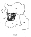
- the map of Figure 2 may form part of a larger area such as illustrated in Figure 3 .
- the larger area is the country of France and is shown divided into five different areas/maps 300,302,304,306,308.
- the differing maps may be stored with differing resolution to allow more or less detail as may be required.
- the coarse location identifier can be used to select between the maps in the area of overlap.
- the selection of which map to choose can be either determined using additional information from the initial request received or from the contents of the quadtree based on a map reference existing at a particular quadtree node.
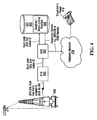
- FIG. 4 shown is a particular example of a detailed call flow provided by an embodiment of the invention.
- Call flow steps are shown implemented between a mobile station, in this case a cab radio 400 equipped with GPS, a wireless network consisting of a base station and/or base station controller (BTS/BSC) 402 and a mobile switching centre 404, and a quadtree-based lookup function 405 implemented in an SCP (service control point) 406.
- SCP service control point
- a telephony network 408 and a dispatcher's telephone 410.
- UUIE user to user information element
- the BTS/BSC 402 forwards a call set-up request to the MSC 404 containing the short code and the GPS information.
- the MSC 404 then sends a query to the SCP 406.
- the query contains the location information consisting of a cell identifier, and the UUIE contents that among other things includes the GPS information.
- the SCP 406 decodes the UUIE contents to obtain the GPS information.
- the SCP uses the short code and the cell identifier to identify the appropriate map to select. Once the map is selected, the quadtree lookup is performed in order to determine the corresponding dispatcher.
- the SCP then directs the MSC 404 to route the call to that dispatcher's telephone number. In the illustrated example, this takes place through telephony network 408.
- FIG. 5 An example of a GSM-R network is shown in Figure 5 .
- a mobile switching centre 500 and two base station controllers 502,504.
- Base station control 502 is servicing base stations 506,508 and base station controller 504 is shown servicing base stations 510,512,514.
- Each base station has a respective wireless coverage area.
- shown are a series of radios 516 in the coverage areas of the base stations.
- the mobile switching centre 500 might also have other connectivity for allowing the GSM-R system to be connected to other networks such as the PSTN (Public Switch Telephone Network) 520, telephone network 522, other EIRENE (European Integrated Railway Radio Enhanced Network) system 524, data network 526, or a PABX (Private Automatic Branch Exchange) 528.
- PSTN Public Switch Telephone Network
- EIRENE European Integrated Railway Radio Enhanced Network
- PABX Primary Broadband Exchange
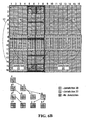
- Figure 6A shows an example of how a lookup might proceed in an 8 x 8 pixel graphic.
- the graphic is shown divided into two jurisdictions, namely jurisdiction A 600 and jurisdiction B 602.
- the figure also shows that the jurisdictions are divided by a river 604.
- each pixel represents about 3 metres squared which is about the useful limit of normal GPS resolution.
- Jurisdiction boundaries will not be precisely smooth since they must conform to pixel boundaries.
- the resulting quadtree is generally indicated at 606 and is completely defined by six nodes labelled Node 1, Node 2, Node 3, Node 4, Node 5, Node 6.
- Node 1 shows the original graphic divided into four quadrants. All co-ordinates in the lower right quadrant have jurisdiction B. Similarly, all co-ordinates in the upper left quadrant point to Node 2 which shows three quadrants that are completely within jurisdiction A, and a fourth quadrant that points to Node 4. Node 4 shows three quadrants in jurisdiction A and a fourth quadrant entirely in jurisdiction B. Similarly, the upper right hand quadrant of Node 1 points to Node 3. In Node 3, the two right hand quadrants all have jurisdiction B. The upper left hand quadrant points to Node 5 and the lower left quadrant points to Node 6.
- spatial storage structure is in this case a quadtree, but other hierarchical spatial representations can alternatively be employed.
- a structure could be employed to reference regions within a hexagonal mesh.
- the quadtree is preferred and detailed here because of the simplicity of the calculations that results from the direct correlation of the measurements axis with the pixel axis.
- the method generally involves storing a hierarchical spatial representation that defines a value of a location dependent information element for a geographical coverage area.
- the location dependent information element was one of various functional entities such as dispatchers or power controllers, and the hierarchical spatial representation as a quadtree that stores a colour or other graphical display characteristic for each jurisdiction that is mappable to a respective instance of the functional entity.
- the method can be applied to any location dependent information elements, and other hierarchical spatial representations can be employed.
- Storage of the location dependent information element using a hierarchical spatial representation is done at step 7-1.
- step 7-2 for a particular location within the geographical coverage area, the value of the location dependent information element is looked up using the hierarchical spatial representation.
- the method of Figure 7 may be implemented in any one or appropriate combination of hardware, firmware, and software. Preferably, implementations allow automatic execution.
- step 7-1 above involves storing a graphic consisting of a set of polygons each having a respective colour that is associated with a respective value of the location dependent information element.
- the hierarchical spatial representation defines and stores the colour of each pixel in the graphic.
- the particular location can be converted into co-ordinates of a pixel within the graphic.
- the colour of the pixel is then determined using the stored hierarchical spatial representation and the colour of the pixel is mapped to the location dependent information element.
- colour is a human factors requirement that enables the visualization of the jurisdiction map.
- the colours allow a human correlation of a jurisdiction to a map region.
- a geographical information system can then create a pixel based graphic where each colour's pixel represents a particular jurisdiction.
- the pixel based graphic is then converted into a quadtree which encodes the pixel colour information, which also still represents jurisdictions, into an efficient reference structure.
- colour or more generally graphical display characteristics can be employed to allow a visualization of the jurisdiction map. More generally, assuming either that visualization is not a requirement, or independent visualization system is available, the quadtree can be used to store any information that represents the jurisdictions/location dependent information elements. This can be information that requires a further mapping to determine the jurisdiction/location dependent information element as was the case for colour, or the information can be full or partial jurisdiction/location dependent information per se.
- the information as looked up includes, potentially among other information, connection information that allows for a connection to be made to a destination functional entity.
- connection information might be a telephone number of a particular location dependent functional entity. Alternatively it could be an IP address, SIP URI, SS7 Point Code or any appropriate network element identifier.
- the connection information can consist of connection information for use in the GSM-R numbering plan.
- the connection information can be a functional number, which can be further resolved by the GSM-R network into a physical number (either an MSISDN or ISDN number), or a physical MSISDN or ISDN number may be directly returned.
- the method further involves initiating the establishment of a connection between the calling device and the geographically dependent functional entity. This may involve performing a call set up for example.
- a respective quadtree is stored for each of a set of different location dependent information elements.
- a first quadtree might be stored for dispatchers while a second quadtree stored for power controllers.
- multiple quadtrees can be stored for any set of location dependent information elements. In that case, in order to perform the lookup, the location is required, but also a selection of a particular one of the location dependent information elements is required. In the above example, this has been achieved by the end user dialing a particular short code. However, more generally any appropriate mechanism for selecting a particular one of the location dependent information elements to lookup can be employed.
- the location information has consisted of GPS data. More generally, this can be any location information that defines the location of the calling party to the requisite resolution. This may come in the form of latitude and longitude, but does not necessarily need to so long as whatever form the location information takes, it can be mapped to the quadtree. In some embodiments, coarse location information is used to determine which of a plurality of different quadtrees to use. In the above detailed description, a particular example of this was given where a cell identifier was used to decide which of a set of maps to use.
- the quadtree-based lookup functionality is implemented in a service control point.
- Service control points are a well-known mechanism providing additional functionality outside the central controller or switch.
- the relevant network element Upon receipt of a call set up request or other communication, the relevant network element will trigger a query to the SCP.
- the trigger to initiate activities on the SCP will be receipt of a particular short code.
- other triggers can alternatively be employed.
- the lookup function does not need to be implemented in a SCP and may or may not involve the use of a trigger-based mechanism. It is most efficient to implement the lookup a single time in a centrally located manner. However, if storage space were less of a requirement, the lookup information could be replicated in multiple distributed locations.
- the function might be implemented in base stations, base station controllers or mobile switching centres to name a few examples.
- the particular MSC BSC BTS hierarchy is a particular example of how GSM-R systems might be implemented. Other network hierarchies can alternatively be employed.
- Figure 8 shows a specific example of how a data structure might be stored for the example quadtree of Figure 6A .
- the arrangement of an array of the six nodes is shown such that position in the array is a function of the position within the quadtree.
- Subelements within a node are either identifiers of a pixel color or a pointer to a child node. Any subelement with its most significant bit set is interpreted as a pixel color.
- the array has four subelements for each node. For example, with respect to Node 1, the first subelement contains a pointer to Node 2, which is located at position 4. The second subelement contains a pointer to Node 3, which is located at position 8.
- the third and fourth subelements contain 0x81, which indicates that the third and fourth quadrants are in jurisdiction B.
- Another embodiment provides a computer readable medium having computer executable instructions stored thereon for implementing the methods described herein.
Landscapes
- Engineering & Computer Science (AREA)
- Computer Networks & Wireless Communication (AREA)
- Signal Processing (AREA)
- Databases & Information Systems (AREA)
- Mobile Radio Communication Systems (AREA)
- Position Fixing By Use Of Radio Waves (AREA)
Description
- The invention relates to location-based addressing, for example for application to GSM-R (Groupe Special Mobile-Rail) applications.
- GSM-R is a variant of GSM that has been developed for rail operations. It extends existing GSM by adding new frequencies and parameters etc. for use by railroad operators, and provides a new customer base for GSM platforms. Before GSM-R, it was common to have multiple different communication standards being used in a railroad yard, for example yard workers, engineers and controllers might be operating with handsets using different standards. GSM-R is an effort to standardize the communications used across Europe for railroad communications.
- One of the requirements of the GSM-R network is that location dependent addressing must be made available. Through location dependent addressing, a caller is capable of dialing a special short code that is associated with a particular function, for example a dispatcher. The location dependent addressing system is responsible for determining the nearest party that meets that functional description, i.e. the nearest dispatcher. The call is then connected through to that nearest dispatcher. Originally, it was thought that location information in the form of a cell identifier that identifies the cell that the caller resides in would be sufficient. This would be true assuming that the location dependent service is common within an entire cell. However, it was recognized that there was a general industry problem with using only the cell identifier for location information. More precision was needed. This is because in some systems, typical cells might be six kilometers in radius, and this is not precise enough. For example there might be 25 train tracks in a train station and there may be different dispatchers assigned for different train tracks. In such a case, the location information would need to be precise enough to be associated with a particular train track. eLDA (enhanced location dependent address) is the industry's response to this requirement for more precision. eLDA specifies mechanisms for transmitting more detailed location information through the network. With eLDA, the entity responsible for looking up the location dependent address is now given more information than just the cell identifier.
- It has been recognized that GPS (global positioning system) data might be useful in this context. The standard as implemented today specifies that upon dialing one of a set of stipulated short codes, GPS co-ordinates are connected from the dialing party and transmitted to a function responsible for performing a location dependent addressing. The cell identifier is also included. The system is then responsible for determining the appropriate location dependent party to handle the call. The standard is silent as to how the GPS data is used in implementing this function.
- International patent application publication
WO 00/51267 - A publication entitled "location dependent addressing using GSM-R cellular positioning" by Liao Min and Zhong Zhangdui, Proceedings of the 16th International Conference on Communication Technology, vol. 1, 2000, pages: 748 - 753 analyzes the possibility of using GSM-R positioning in LDA (location dependent addressing). The characteristic of GSM-R compatible with cellular positioning is given. A location system model as well as positioning techniques suitable for a GSM-R system are presented.
- A publication entitled "GSK-R System Procurement Guide" by A F Neele and A T Wootton, 23 May 2003, provides an overview of GSM-R and gives a single point reference for all of the relevant documentation. The publication further describes various design options available and how these implementations can be made to result in an interoperable EIRENE (European integrated railway enhanced network) compliant system. The publication also provides guidance on issues, which have an effect on implementation and interoperability, but are not comprehensively covered in the EIRENE specifications.
- According to one broad aspect, the invention provides a method comprising receiving a call setup request requesting a connection between a calling device and a location dependent functional entity; looking up connection information to a particular intrance of the location dependent functional entity as a function of location of the calling device; using the connection information for initiating the establishment of a connection between said calling device and said instance of the location dependent functional entity, wherein, at least one location dependent functional entity storing a plurality of hierarchical spatial representations in the form of quadtrees each defining different connection information using the cell identifier of the call the calling device resides in which of the plurality of quadtrees to use. in said step of looking up
- In some embodiments, information, identifying the particular location dependent functional entity is identified by a GSM-R short code.
- In some embodiments, the information identifying the particular location comprises latitude and longicude information.
- In some embodiments, storing the quadtree comprises storing higher resolution nodes in the quadtree for areas where a higher resolution location-based lookup is to be provided.
- In some embodiments, the method as summarized above implemented in a service control point.
- According to another broad aspect, the invention provides a system comprising the features of
claim 6. - In some embodiments, the hierarchical spatial representation-based lookup function is implemented in a service control point.
- In some embodiments, the system is a GSM-R system.
- Preferred embodiments of the invention will now be described with reference to the attached drawings in which:
-
Figure 1 is a schematic diagram of a system provided by an embodiment of the invention employing quadtree-based lookup; -
Figure 2 is an example of a map that has been divided into polygons and stored using a quadtree; -
Figure 3 shows the map ofFigure 2 as part of a larger overall map; -
Figure 4 shows an example of a call flow for performing dispatcher lookup as provided by an embodiment of the invention; -
Figure 5 is a system diagram of an example GSM-R network; -
Figures 6A and6B are detailed examples of how 8 x 8 and 16 x 16 pixel graphics can be stored efficiently using a quadtree; -
Figure 7 is a flowchart of an example method of using a hierarchical spatial representation to lookup a value of a location dependent information element; and -
Figure 8 is an example of a data structure for storing the quadtree ofFigure 6A . - Referring now to
Figure 1 , shown is a schematic view of an example system employing quadtree-based lookup to deliver location dependent addressing provided by an embodiment of the invention. Shown is atrain track 10 passing through a series ofcells track 10. Thecells wireless access network 24. Also shown are twodispatcher jurisdictions track 10 is located withinjurisdiction 20 and part of the track is located withinjurisdiction 22, and that the boundaries of the dispatcher jurisdictions are not generally in common with boundaries of the cells. Amobile station 32 equipped with a GPS (global positioning system) capability or some other location determining capability is shown travelling on atrain 33 withincell 12. The details of the access infrastructure within thecells wireless access network 24 are not shown. Also shown is a quadtree-basedlookup function 26 in communication with and/or forming part of thewireless access network 24. Also shown is adispatcher 34 in communication with thewireless access network 24 throughconnection 30. - In operation, when a new call is originated by a user within one of the cells (for example using
mobile station 32 within cell 12), the request is received by thewireless access network 24. For example, if the call is an eLDA call, the call is originated to a short code, and the request includes both the short code associated with a request for a dispatcher and the GPS latitude and longitude. More generally, the request includes location information and something that can be associated with a particular location dependent information element, as detailed below. Thewireless access network 24 sends a query for the location dependent destination of the call using the short code and the latitude and longitude to the quadtree-based lookup function 26 (more generally, to a hierarchical spatial representation lookup function as detailed below). - In some embodiments, the query also includes a coarse location identifier such as a cell identifier. This can either be included in the original call by the mobile station, or added by the network, for example by base stations, base station controllers (not shown), a mobile switching centre or other network elements. The quadtree-based
lookup function 26 responds with the appropriate destination, and thewireless access network 24 then sets upconnection 30 to theappropriate dispatcher 34. It is of course to be understood that many of the interconnections are logical inFigure 1 and there may be other intervening infrastructures. - Preferably, the quadtree-based lookup function is broken down along geographical boundaries, for example by providing one quadtree-based lookup function per country. Note that while in the illustrated example, the location dependent addressing function is provided in the quadtree-based lookup function that is shown distinct from the wireless access network, more generally it can be provided in any appropriate manner that may or may not form part of the wireless access network, for example in a switch. The quadtree-based
lookup function 26 is responsible for taking the location information and the short code, and determining the appropriate target. For the particular example illustrated, it is assumed that it is a dispatcher that is being requested (the current standard stipulates that short code 1200 is used to request a dispatcher). The twojurisdictions Figure 1 are assumed to be for dispatchers. As such, the quadtree-basedlookup function 26 is responsible for determining which of thejurisdictions 20,22 (more generally there would be a larger number) the caller is located in, and then mapping that to an appropriate dispatcher, and returning this information to thewireless access network 24. In the illustrated example,dispatcher 34 is the current destination for calls withinjurisdiction 20. - A new method of mapping location information to jurisdiction is implemented by the quadtree-based
lookup function 26. In the description that follows, the jurisdictions are assumed to be dispatcher jurisdictions. However, in a given implementation, the jurisdiction can be application dependent, and in fact there can be multiple different jurisdictions that are defined for different functional entities that may be co-extensive for some functions, or completely independent. In the GSM-R application, it is the short code that specifies which functional entity is being requested. More generally, other methods of requesting a particular functional entity can be employed. For example, a full telephone number, instant message URI, SIP address associated with the bearer or media type could be used. - Furthermore, more generally, once the jurisdiction is determined, this information can be used for more than just setting up a voice call. For example, it can be used for establishing a FAX or data call, directing an SMS or an IM, or establishing an IP or a SIP connection. Any value which unambiguously identifies a network element could be used.
- To begin, the method by which a geographical coverage area is efficiently stored in a data structure for lookup purposes will be described.
- Referring to
Figure 2 , shown is an example of a coverage area that will be used for the purpose of describing how the data structure is generated. The coverage area falls within four corners P1,P2,P3,P4 each having associated latitude and longitude. The region is divided into polygons that follow jurisdictional boundaries. In the illustrated example, it can be seen that there are 16 polygons defining 16 different jurisdictions. Typically, the jurisdictions are defined by the operator since the operator will be responsible for deciding where jurisdiction will lie. There might be a different map such as the one shown inFigure 2 for different functional entities. For example there might be a first map for dispatchers, and a second map for power controllers, etc., that represents the same geographical area. - For the purpose of graphical rendering, each polygon is assigned a respective colour or other graphically unique display characteristic. As such, the 16 polygons shown in
Figure 2 are each shown with a different colour, although for the purpose of a black and white figure, different hatchings are shown. Each colour is directly associated with a respective jurisdiction, e.g. a respective dispatcher jurisdiction. Because of the unique color associated with each jurisdiction within the overall geographical region, jurisdictions with disjoint regions can also be supported. Generally, each region can be disjoint or contiguous. - The information is stored using a quadtree. A quadtree is a mapping approach that progressively refines a map area into increasingly small quadrants until an entire quadrant is covered by one colour. The mapping of polygons into quadtrees provides storage compression and lookup speed as will be described in further detail below. Quadtrees are explained in detail in Irene Gargantini, "An Effective Way to Represent Quadtrees", Communication of the ACM, Vol. 25, No. 12, pp 905-910, 1982, No. 12, pp 905-910, 1982 , and in Hana Samet, "The Quadtree and Related Hierarchical Data Structures, ACM Computing Survey, vol. 16, no. 2, pp 187-260, 1984.
- To begin, the map of
Figure 2 is mapped to an associated graphic consisting of rows of pixels, each pixel having a colour corresponding to the polygon region in which it resides. The resolution of the graphic, combined with the precision of the GPS co-ordinates, will define the resolution of the location lookup capability. For the purpose of example, it is assumed that the graphic inFigure 2 is mapped to a 512 x 512 pixel graphic. Each pixel has (x,y) coordinates. Corner P1 is associated with (0,0), corner P2 is associated with (0,511), corner P3 is associated with (511,0), and corner P4 is associated with (511,511). For the region indicated inFigure 3 described below, an area one third the width and one third the height of France or approximately 250 km by 250 km, a low resolution image of 500 by 500 pixels would allow resolution to an area of 500m by 500m. An overlay map of 1.8 km by 1.8 km for each area containing a train yard could be represented by a graphic of 600 by 600 pixels in order to support a 3 meter resolution that is desirable for locations within the train yard. - A simple example of a quadtree is indicated at 100 in
Figure 2 . Note the quadtree ofFigure 2 is shown to illustrate how quadtrees work, and does not map to the graphic 50. Thetop node 102 covers the whole graphic 50 and is shown divided into four quadrants 104,106,108,110. The four quadrants are defined in terms of the pixels that made up the graphic. Thus, thequadrant 104 is defined by upper left and lower right corners (0,0) and (255,255) respectively. The other quadrants are similarly defined. - For each quadrant, if the entire area of the quadrant is assigned a single colour for all pixels in the quadrant, then the encoding of that quadrant is complete. On the other hand, if the particular quadrant does not have a single colour associated with it, then that quadrant is broken down again into four further quadrants. In the illustrated example, each of the four quadrants 104,106,108,110 of the
top node 102 has been broken down into four quadrants in respective second-level nodes 112,114,116,118. For a second-level node 112, it can be seen that the top two quadrants are all one colour, and as such the encoding of these quadrants is done. Similarly, the lower right quadrant of thatnode 112 is also one colour and as such the encoding of that node is done. For the remaining quadrant ofnode 112, a third-level node 120 divides that quadrant into four further quadrants as shown. A similar process is repeated for each second-level node with each tree branch ending when each quadrant is coloured by only a single colour. - Once the information has been encoded into a quadtree as defined above, a latitude and longitude of a calling party can be used to very efficiently lookup the jurisdiction associated with the caller's location.
- The quadtree allows a complex data structure (in this case, a geographical map of jurisdictions) to be efficiently and compactly stored, minimizing the data requirements.
- Furthermore, GSM-R networks typically have strict call set-up duration guidelines. Fast lookup of dispatchers from GPS co-ordinates would be advantageous in reducing call set-up times. Using quadtrees allows the number of recursions to be reduced/minimized, and provides a time-efficient method of looking up dispatcher information during an e-LDA call.
- By specifying the number of pixels in a given map, this solution allows maps of variable granularity. Furthermore, in this solution, maps may overlap. Train operators can therefore have a map specifying a large part of a country side with more granular maps showing detailed areas in areas such as switching yards or train stations. As well, at any quadrant of the quadtree node, a submap with finer pixel resolution may also be referenced such that all child nodes of the node containing the map reference will resolve to the finer level of detail. This is the second of the two methods provided for allowing arbitrary levels of detail without requiring overly large graphics to represent a region.
- Typically, a coarse location indicator, for example a cell identifier, could be used to determine which map to use when there are multiple maps. For example, the map of
Figure 2 may form part of a larger area such as illustrated inFigure 3 . In this case, the larger area is the country of France and is shown divided into five different areas/maps 300,302,304,306,308. The differing maps may be stored with differing resolution to allow more or less detail as may be required. In the event maps overlap, the coarse location identifier can be used to select between the maps in the area of overlap. - More generally, the selection of which map to choose can be either determined using additional information from the initial request received or from the contents of the quadtree based on a map reference existing at a particular quadtree node.
- Referring now to
Figure 4 , shown is a particular example of a detailed call flow provided by an embodiment of the invention. Call flow steps are shown implemented between a mobile station, in this case acab radio 400 equipped with GPS, a wireless network consisting of a base station and/or base station controller (BTS/BSC) 402 and amobile switching centre 404, and a quadtree-basedlookup function 405 implemented in an SCP (service control point) 406. Also shown is atelephony network 408 and a dispatcher'stelephone 410. To begin, when an operator of thecab radio 400 dials a short code, GPS information is obtained and included in the UUIE (user to user information element) that is transmitted to the BTS/BSC 402. The BTS/BSC 402 forwards a call set-up request to theMSC 404 containing the short code and the GPS information. TheMSC 404 then sends a query to theSCP 406. The query contains the location information consisting of a cell identifier, and the UUIE contents that among other things includes the GPS information. - Next, the
SCP 406 decodes the UUIE contents to obtain the GPS information. The SCP uses the short code and the cell identifier to identify the appropriate map to select. Once the map is selected, the quadtree lookup is performed in order to determine the corresponding dispatcher. The SCP then directs theMSC 404 to route the call to that dispatcher's telephone number. In the illustrated example, this takes place throughtelephony network 408. - For the purpose of context, an example of a GSM-R network is shown in
Figure 5 . There is amobile switching centre 500 and two base station controllers 502,504.Base station control 502 is servicing base stations 506,508 andbase station controller 504 is shown servicing base stations 510,512,514. Each base station has a respective wireless coverage area. In the illustrated example, shown are a series ofradios 516 in the coverage areas of the base stations. Themobile switching centre 500 might also have other connectivity for allowing the GSM-R system to be connected to other networks such as the PSTN (Public Switch Telephone Network) 520,telephone network 522, other EIRENE (European Integrated Railway Radio Enhanced Network)system 524,data network 526, or a PABX (Private Automatic Branch Exchange) 528. Also shown is anSCP 530 that is responsible for performing the location dependent lookups. -
Figure 6A shows an example of how a lookup might proceed in an 8 x 8 pixel graphic. In this case, the graphic is shown divided into two jurisdictions, namelyjurisdiction A 600 andjurisdiction B 602. The figure also shows that the jurisdictions are divided by ariver 604. In this example, each pixel represents about 3 metres squared which is about the useful limit of normal GPS resolution. Jurisdiction boundaries will not be precisely smooth since they must conform to pixel boundaries. - The resulting quadtree is generally indicated at 606 and is completely defined by six nodes labelled
Node 1,Node 2,Node 3,Node 4,Node 5,Node 6.Node 1 shows the original graphic divided into four quadrants. All co-ordinates in the lower right quadrant have jurisdiction B. Similarly, all co-ordinates in the upper left quadrant point toNode 2 which shows three quadrants that are completely within jurisdiction A, and a fourth quadrant that points toNode 4.Node 4 shows three quadrants in jurisdiction A and a fourth quadrant entirely in jurisdiction B. Similarly, the upper right hand quadrant ofNode 1 points toNode 3. InNode 3, the two right hand quadrants all have jurisdiction B. The upper left hand quadrant points toNode 5 and the lower left quadrant points toNode 6. InNode 5, the two left quadrants are jurisdiction A while the two right quadrants are jurisdiction B. InNode 6, the upper left quadrant is jurisdiction A while the remaining quadrants are jurisdiction B. At this point, all of the quadrants have a single colour and as such no further breakdown is required. - With this particular example, a quadtree for an 8 x 8 pixel graphic has been illustrated. The obvious way to store information for each pixel of an 8 x 8 graphic would require a 64 byte matrix, assuming one byte per pixel of colour data. In contrast, with the above-described method of storage, only 24 bytes are required, assuming an optimal arrangement of pointers and one byte pixel colour data as a quadrant array. In this particular instance, a maximum of three compares is required for retrieval while some co-ordinates require only a single compare. Another example is shown in
Figure 6B where a quadtree for a trainyard having jurisdictions cells - The choice of spatial storage structure is in this case a quadtree, but other hierarchical spatial representations can alternatively be employed. For example, a structure could be employed to reference regions within a hexagonal mesh. The quadtree is preferred and detailed here because of the simplicity of the calculations that results from the direct correlation of the measurements axis with the pixel axis.
- The above-described embodiments have focussed on GSM-R applications. More generally, the methods described herein can be applied to any system in which a lookup of a value of a particular location dependent information element needs to be performed. Referring to the flowchart of
Figure 7 , the method generally involves storing a hierarchical spatial representation that defines a value of a location dependent information element for a geographical coverage area. In particular examples that were given above, the location dependent information element was one of various functional entities such as dispatchers or power controllers, and the hierarchical spatial representation as a quadtree that stores a colour or other graphical display characteristic for each jurisdiction that is mappable to a respective instance of the functional entity. However, the method can be applied to any location dependent information elements, and other hierarchical spatial representations can be employed. Storage of the location dependent information element using a hierarchical spatial representation is done at step 7-1. At step 7-2, for a particular location within the geographical coverage area, the value of the location dependent information element is looked up using the hierarchical spatial representation. - The method of
Figure 7 may be implemented in any one or appropriate combination of hardware, firmware, and software. Preferably, implementations allow automatic execution. - In a particular implementation, step 7-1 above involves storing a graphic consisting of a set of polygons each having a respective colour that is associated with a respective value of the location dependent information element. The hierarchical spatial representation defines and stores the colour of each pixel in the graphic.
- To use the graphic stored as such, the particular location can be converted into co-ordinates of a pixel within the graphic. The colour of the pixel is then determined using the stored hierarchical spatial representation and the colour of the pixel is mapped to the location dependent information element.
- The use of colour is a human factors requirement that enables the visualization of the jurisdiction map. The colours allow a human correlation of a jurisdiction to a map region. A geographical information system can then create a pixel based graphic where each colour's pixel represents a particular jurisdiction. The pixel based graphic is then converted into a quadtree which encodes the pixel colour information, which also still represents jurisdictions, into an efficient reference structure.
- As indicated above, colour or more generally graphical display characteristics can be employed to allow a visualization of the jurisdiction map. More generally, assuming either that visualization is not a requirement, or independent visualization system is available, the quadtree can be used to store any information that represents the jurisdictions/location dependent information elements. This can be information that requires a further mapping to determine the jurisdiction/location dependent information element as was the case for colour, or the information can be full or partial jurisdiction/location dependent information per se.
- Preferably, the information as looked up includes, potentially among other information, connection information that allows for a connection to be made to a destination functional entity. For example, the connection information might be a telephone number of a particular location dependent functional entity. Alternatively it could be an IP address, SIP URI, SS7 Point Code or any appropriate network element identifier. For the particular detailed example given above where the quadtree is used to lookup a particular dispatcher, the connection information can consist of connection information for use in the GSM-R numbering plan. The connection information can be a functional number, which can be further resolved by the GSM-R network into a physical number (either an MSISDN or ISDN number), or a physical MSISDN or ISDN number may be directly returned.
- In some embodiments the method further involves initiating the establishment of a connection between the calling device and the geographically dependent functional entity. This may involve performing a call set up for example.
- In some implementations, a respective quadtree is stored for each of a set of different location dependent information elements. For example, a first quadtree might be stored for dispatchers while a second quadtree stored for power controllers. More generally, multiple quadtrees can be stored for any set of location dependent information elements. In that case, in order to perform the lookup, the location is required, but also a selection of a particular one of the location dependent information elements is required. In the above example, this has been achieved by the end user dialing a particular short code. However, more generally any appropriate mechanism for selecting a particular one of the location dependent information elements to lookup can be employed.
- In the detailed examples above, the location information has consisted of GPS data. More generally, this can be any location information that defines the location of the calling party to the requisite resolution. This may come in the form of latitude and longitude, but does not necessarily need to so long as whatever form the location information takes, it can be mapped to the quadtree. In some embodiments, coarse location information is used to determine which of a plurality of different quadtrees to use. In the above detailed description, a particular example of this was given where a cell identifier was used to decide which of a set of maps to use.
- In some embodiments, the quadtree-based lookup functionality is implemented in a service control point. Service control points are a well-known mechanism providing additional functionality outside the central controller or switch. Upon receipt of a call set up request or other communication, the relevant network element will trigger a query to the SCP. In the particular example, the trigger to initiate activities on the SCP will be receipt of a particular short code. However, other triggers can alternatively be employed. More generally, it is readily apparent that the lookup function does not need to be implemented in a SCP and may or may not involve the use of a trigger-based mechanism. It is most efficient to implement the lookup a single time in a centrally located manner. However, if storage space were less of a requirement, the lookup information could be replicated in multiple distributed locations. For example, the function might be implemented in base stations, base station controllers or mobile switching centres to name a few examples. The particular MSC BSC BTS hierarchy is a particular example of how GSM-R systems might be implemented. Other network hierarchies can alternatively be employed.
-
Figure 8 shows a specific example of how a data structure might be stored for the example quadtree ofFigure 6A . The arrangement of an array of the six nodes is shown such that position in the array is a function of the position within the quadtree. Subelements within a node are either identifiers of a pixel color or a pointer to a child node. Any subelement with its most significant bit set is interpreted as a pixel color. The array has four subelements for each node. For example, with respect toNode 1, the first subelement contains a pointer toNode 2, which is located atposition 4. The second subelement contains a pointer toNode 3, which is located atposition 8. The third and fourth subelements contain 0x81, which indicates that the third and fourth quadrants are in jurisdiction B. - It is to be understood that the example discussed with reference to
Figure 8 is a very specific example. There are many ways that a quadtree can be stored. Any suitable data structure allowing reading and writing of the quadtree may be implemented. - Another embodiment provides a computer readable medium having computer executable instructions stored thereon for implementing the methods described herein.
- Numerous modifications and variations of the present invention are possible in light of the above teachings. It is therefore to be understood that within the scope of the appended claims, the invention may be practiced otherwise than as specifically described herein.
Claims (10)
- A method for location-dependent addressing in a wireless access network (24) having cells with cell identifiers, comprising:receiving a call setup request requesting a connection between a calling device (32, 400, 516) and a location-dependent functional entity;looking up (7-2) connection information to a particular instance (34, 41C) of the location-dependent functional entity as a function of the location of the calling device (32, 400, 516); andusing the connection information for initiating the establishment of a connection between said calling device (32, 400, 516) and said instance (34, 410) of the location-dependent functional entity;characterized by:for at least one location-dependent functional entity, storing (7-1) a plurality of hierarchical spatial representations in the form of quadtrees (100, 606) each defining different connection information;using the cell identifier of the cell the calling device (32, 400, 516) resides in to determine which of the plurality of quadtrees (100, 606) to use in said step of looking up (7-2).
- The method of claim 1, characterized in that the particular location-dependent functional entity is identified by a GSM-R short code.
- The method of claim 1 or 2, characterized in that the location of the calling device (32, 400, 516) is identified by latitude and longitude information.
- The method of any one of claims 1 to 3, characterized in that storing the quadtrees (100, 606) comprises storing higher resolution nodes (112, 114, 116, 118, 120) in the quadtrees (100, 606) for areas where a higher resolution location-based look-up (7-2) is to be provided.
- The method of any one of claims 1 to 4 implemented in a service control point (406, 530).
- A system for location-dependent addressing for a wireless access network (24) having cells with cell identifiers, configured to receive a call setup request requesting a connection between a calling device (32, 400, 516) and a location-dependent functional entity, to look-up (7-2) connection information to a particular instance (34, 410) of the location-dependent functional entity as a function of the location of the calling device (32, 400, 516), and to use the connection information for initiating the establishment of a connection between said calling device (32, 400, 516) and said instance (34, 410) of the location-dependent functional entity; characterized by:means for storing (7-1), for at least one location-dependent functional entity, a plurality of hierarchical spatial representations in the form of quadtrees (100, 606) each defining different connection information, andmeans for using the cell identifier of the cell the calling device (32, 400, 516) resides in to determine which of the plurality of quadtrees (100, 606) to use in said look-up (7-2).
- The system of claim 6, characterized in that the system is a GSM-R system.
- The system of claims 6 or 7, characterized in that the location of the calling device (32, 400, 516) is identified by latitude and longitude information.
- The system of any one of claims 6 to 8, characterized in that the quadtree-based look-up (7-2) is implemented in a service control point (406, 530).
- One or more computer readable media having computer executable instructions for executing the method of any of claims 1 to 5.
Priority Applications (2)
| Application Number | Priority Date | Filing Date | Title |
|---|---|---|---|
| SI200631597T SI1771025T1 (en) | 2005-09-30 | 2006-09-15 | Location dependent adressing for GSM-R systems |
| PL06019401T PL1771025T3 (en) | 2005-09-30 | 2006-09-15 | Location dependent adressing for GSM-R systems |
Applications Claiming Priority (1)
| Application Number | Priority Date | Filing Date | Title |
|---|---|---|---|
| US11/239,346 US20070077942A1 (en) | 2005-09-30 | 2005-09-30 | Location-based addressing |
Publications (3)
| Publication Number | Publication Date |
|---|---|
| EP1771025A2 EP1771025A2 (en) | 2007-04-04 |
| EP1771025A3 EP1771025A3 (en) | 2007-12-19 |
| EP1771025B1 true EP1771025B1 (en) | 2013-03-13 |
Family
ID=37671989
Family Applications (1)
| Application Number | Title | Priority Date | Filing Date |
|---|---|---|---|
| EP06019401A Active EP1771025B1 (en) | 2005-09-30 | 2006-09-15 | Location dependent adressing for GSM-R systems |
Country Status (4)
| Country | Link |
|---|---|
| US (1) | US20070077942A1 (en) |
| EP (1) | EP1771025B1 (en) |
| PL (1) | PL1771025T3 (en) |
| SI (1) | SI1771025T1 (en) |
Families Citing this family (13)
| Publication number | Priority date | Publication date | Assignee | Title |
|---|---|---|---|---|
| US12439340B2 (en) | 2007-08-14 | 2025-10-07 | Mpanion, Inc. | Real-time location and presence using a push-location client and server |
| US8489111B2 (en) | 2007-08-14 | 2013-07-16 | Mpanion, Inc. | Real-time location and presence using a push-location client and server |
| US8050690B2 (en) | 2007-08-14 | 2011-11-01 | Mpanion, Inc. | Location based presence and privacy management |
| US8583079B2 (en) | 2007-08-14 | 2013-11-12 | Mpanion, Inc. | Rich presence status based on location, activity, availability and transit status of a user |
| CN101321367B (en) * | 2008-07-22 | 2011-10-12 | 北京六捷科技有限公司 | Monitoring system and method for railway locomotive integration radio communication apparatus |
| US8504073B2 (en) | 2008-08-12 | 2013-08-06 | Teaneck Enterprises, Llc | Customized content delivery through the use of arbitrary geographic shapes |
| US7921223B2 (en) | 2008-12-08 | 2011-04-05 | Lemi Technology, Llc | Protected distribution and location based aggregation service |
| RU2405280C1 (en) * | 2009-05-21 | 2010-11-27 | Открытое акционерное общество "Российские железные дороги" (ОАО "РЖД") | System of subscriber selection in digital train radio communication |
| CN101616461B (en) * | 2009-07-14 | 2011-07-20 | 北京交通大学 | System for realizing double mode vehicular terminal and method thereof |
| CN102019944B (en) * | 2010-11-23 | 2012-09-19 | 华为技术有限公司 | Train operation control method, automatic train protection (ATP) system and China train control system 3 (CTCS-3) control unit |
| WO2012129741A1 (en) * | 2011-03-25 | 2012-10-04 | 上海磁浮交通发展有限公司 | Train-ground wireless communication system for rail transit and cellular handover method thereof |
| CN102233886B (en) * | 2011-05-16 | 2013-11-13 | 铁道部运输局 | CTCS (China Train Control System)-2 train operation control system |
| CN109768850B (en) * | 2019-03-11 | 2021-06-29 | 北京经纬恒润科技股份有限公司 | An in-vehicle communication method and system |
Family Cites Families (3)
| Publication number | Priority date | Publication date | Assignee | Title |
|---|---|---|---|---|
| EP0952744A3 (en) * | 1998-04-23 | 2000-12-20 | Nortel Networks Limited | A mobile telecommunications system supporting the use of functional numbers |
| US6212392B1 (en) * | 1999-02-26 | 2001-04-03 | Signal Soft Corp. | Method for determining if the location of a wireless communication device is within a specified area |
| US7177623B2 (en) * | 2003-07-02 | 2007-02-13 | The United States Of America As Represented By The Secretary Of The Army | Localized cellular awareness and tracking of emergencies |
-
2005
- 2005-09-30 US US11/239,346 patent/US20070077942A1/en not_active Abandoned
-
2006
- 2006-09-15 EP EP06019401A patent/EP1771025B1/en active Active
- 2006-09-15 SI SI200631597T patent/SI1771025T1/en unknown
- 2006-09-15 PL PL06019401T patent/PL1771025T3/en unknown
Also Published As
| Publication number | Publication date |
|---|---|
| US20070077942A1 (en) | 2007-04-05 |
| EP1771025A3 (en) | 2007-12-19 |
| PL1771025T3 (en) | 2013-12-31 |
| SI1771025T1 (en) | 2013-07-31 |
| EP1771025A2 (en) | 2007-04-04 |
Similar Documents
| Publication | Publication Date | Title |
|---|---|---|
| US5619552A (en) | Arrangement and method for location registration | |
| CN1106779C (en) | Cellular communication system, positioning system and method for transmitting position information of roaming mobile station | |
| EP1771025A2 (en) | Location dependent adressing for GSM-R systems | |
| US7072666B1 (en) | Method and system for communicating location in a cellular wireless system | |
| US6636742B1 (en) | Tracking of mobile terminal equipment in a mobile communications system | |
| US6330454B1 (en) | System and method for locating mobile units operating within a wireless communication system | |
| US6529735B1 (en) | Method and arrangement in a communication network | |
| US20040229620A1 (en) | Method and system for routing a telephone call | |
| WO1999027716A1 (en) | Regulatory database within the intelligent network | |
| RU2267865C2 (en) | Method for calling external client of intellectual network in roaming mode | |
| FI96156B (en) | Method and Device for Forming Data Transfer Connection to Data Transfer Devices Located on a Defined Call Area | |
| US7469147B2 (en) | Location services in a packet radio network | |
| CA2299278A1 (en) | Geographical database for radio system | |
| US20050003797A1 (en) | Localized cellular awareness and tracking of emergencies | |
| WO1998016076A1 (en) | Mobile network geographic address translation | |
| JP2008312234A (en) | Location-dependent services in mobile communication systems | |
| US20040198362A1 (en) | Procedure and system for setting up a telecommunication connection | |
| US20080081620A1 (en) | Apparatus, and Associated Method, for Estimating the Location of a GAN-Capable Mobile Station | |
| FI111213B (en) | Procedure for controlling calls from a subscriber's location | |
| CN101420660A (en) | Method for controlling short message transceiving scope of VPN customer | |
| US20030100304A1 (en) | System and method of providing access to intelligent network services from a plurality of telecommunications networks | |
| US20080280617A1 (en) | Target Base Station - Based Media Gateway Selection in a Distributed Mobile Switching Center Environment | |
| US6847815B1 (en) | Method for detecting, on a telecommunication network side, the complexity, on the telecommunication network side, of a telecommunication link between two subscribers in order to determine the rate, and device for realising the same | |
| Kerihuel et al. | How the intelligent network will federate services related to mobility | |
| CN116887305A (en) | A satellite-ground integrated network capability opening method, device and storage medium |
Legal Events
| Date | Code | Title | Description |
|---|---|---|---|
| PUAI | Public reference made under article 153(3) epc to a published international application that has entered the european phase |
Free format text: ORIGINAL CODE: 0009012 |
|
| AK | Designated contracting states |
Kind code of ref document: A2 Designated state(s): AT BE BG CH CY CZ DE DK EE ES FI FR GB GR HU IE IS IT LI LT LU LV MC NL PL PT RO SE SI SK TR |
|
| AX | Request for extension of the european patent |
Extension state: AL BA HR MK YU |
|
| PUAL | Search report despatched |
Free format text: ORIGINAL CODE: 0009013 |
|
| AK | Designated contracting states |
Kind code of ref document: A3 Designated state(s): AT BE BG CH CY CZ DE DK EE ES FI FR GB GR HU IE IS IT LI LT LU LV MC NL PL PT RO SE SI SK TR |
|
| AX | Request for extension of the european patent |
Extension state: AL BA HR MK YU |
|
| RIC1 | Information provided on ipc code assigned before grant |
Ipc: H04Q 7/38 20060101AFI20070201BHEP Ipc: G06F 17/30 20060101ALI20071109BHEP |
|
| 16A | New documents despatched to applicant after publication of the search report |
Effective date: 20071218 |
|
| 17P | Request for examination filed |
Effective date: 20080606 |
|
| 17Q | First examination report despatched |
Effective date: 20080710 |
|
| AKX | Designation fees paid |
Designated state(s): AT BE BG CH CY CZ DE DK EE ES FI FR GB GR HU IE IS IT LI LT LU LV MC NL PL PT RO SE SI SK TR |
|
| RAP1 | Party data changed (applicant data changed or rights of an application transferred) |
Owner name: KAPSCH CARRIERCOM FRANCE S.A.S. |
|
| REG | Reference to a national code |
Ref country code: DE Ref legal event code: R079 Ref document number: 602006034993 Country of ref document: DE Free format text: PREVIOUS MAIN CLASS: H04Q0007380000 Ipc: H04W0004020000 |
|
| RIC1 | Information provided on ipc code assigned before grant |
Ipc: H04W 4/02 20090101AFI20120521BHEP |
|
| GRAP | Despatch of communication of intention to grant a patent |
Free format text: ORIGINAL CODE: EPIDOSNIGR1 |
|
| GRAP | Despatch of communication of intention to grant a patent |
Free format text: ORIGINAL CODE: EPIDOSNIGR1 |
|
| GRAS | Grant fee paid |
Free format text: ORIGINAL CODE: EPIDOSNIGR3 |
|
| GRAA | (expected) grant |
Free format text: ORIGINAL CODE: 0009210 |
|
| AK | Designated contracting states |
Kind code of ref document: B1 Designated state(s): AT BE BG CH CY CZ DE DK EE ES FI FR GB GR HU IE IS IT LI LT LU LV MC NL PL PT RO SE SI SK TR |
|
| REG | Reference to a national code |
Ref country code: GB Ref legal event code: FG4D |
|
| REG | Reference to a national code |
Ref country code: CH Ref legal event code: EP Ref country code: AT Ref legal event code: REF Ref document number: 601409 Country of ref document: AT Kind code of ref document: T Effective date: 20130315 |
|
| REG | Reference to a national code |
Ref country code: IE Ref legal event code: FG4D |
|
| REG | Reference to a national code |
Ref country code: DE Ref legal event code: R096 Ref document number: 602006034993 Country of ref document: DE Effective date: 20130508 |
|
| REG | Reference to a national code |
Ref country code: RO Ref legal event code: EPE |
|
| RAP2 | Party data changed (patent owner data changed or rights of a patent transferred) |
Owner name: KAPSCH CARRIERCOM FRANCE S.A.S. |
|
| PG25 | Lapsed in a contracting state [announced via postgrant information from national office to epo] |
Ref country code: ES Free format text: LAPSE BECAUSE OF FAILURE TO SUBMIT A TRANSLATION OF THE DESCRIPTION OR TO PAY THE FEE WITHIN THE PRESCRIBED TIME-LIMIT Effective date: 20130624 Ref country code: BG Free format text: LAPSE BECAUSE OF FAILURE TO SUBMIT A TRANSLATION OF THE DESCRIPTION OR TO PAY THE FEE WITHIN THE PRESCRIBED TIME-LIMIT Effective date: 20130613 Ref country code: SE Free format text: LAPSE BECAUSE OF FAILURE TO SUBMIT A TRANSLATION OF THE DESCRIPTION OR TO PAY THE FEE WITHIN THE PRESCRIBED TIME-LIMIT Effective date: 20130313 Ref country code: LT Free format text: LAPSE BECAUSE OF FAILURE TO SUBMIT A TRANSLATION OF THE DESCRIPTION OR TO PAY THE FEE WITHIN THE PRESCRIBED TIME-LIMIT Effective date: 20130313 |
|
| REG | Reference to a national code |
Ref country code: NL Ref legal event code: VDEP Effective date: 20130313 |
|
| REG | Reference to a national code |
Ref country code: LT Ref legal event code: MG4D |
|
| PG25 | Lapsed in a contracting state [announced via postgrant information from national office to epo] |
Ref country code: LV Free format text: LAPSE BECAUSE OF FAILURE TO SUBMIT A TRANSLATION OF THE DESCRIPTION OR TO PAY THE FEE WITHIN THE PRESCRIBED TIME-LIMIT Effective date: 20130313 Ref country code: GR Free format text: LAPSE BECAUSE OF FAILURE TO SUBMIT A TRANSLATION OF THE DESCRIPTION OR TO PAY THE FEE WITHIN THE PRESCRIBED TIME-LIMIT Effective date: 20130614 Ref country code: FI Free format text: LAPSE BECAUSE OF FAILURE TO SUBMIT A TRANSLATION OF THE DESCRIPTION OR TO PAY THE FEE WITHIN THE PRESCRIBED TIME-LIMIT Effective date: 20130313 |
|
| REG | Reference to a national code |
Ref country code: SK Ref legal event code: T3 Ref document number: E 14323 Country of ref document: SK |
|
| PG25 | Lapsed in a contracting state [announced via postgrant information from national office to epo] |
Ref country code: BE Free format text: LAPSE BECAUSE OF FAILURE TO SUBMIT A TRANSLATION OF THE DESCRIPTION OR TO PAY THE FEE WITHIN THE PRESCRIBED TIME-LIMIT Effective date: 20130313 |
|
| PG25 | Lapsed in a contracting state [announced via postgrant information from national office to epo] |
Ref country code: IS Free format text: LAPSE BECAUSE OF FAILURE TO SUBMIT A TRANSLATION OF THE DESCRIPTION OR TO PAY THE FEE WITHIN THE PRESCRIBED TIME-LIMIT Effective date: 20130713 Ref country code: PT Free format text: LAPSE BECAUSE OF FAILURE TO SUBMIT A TRANSLATION OF THE DESCRIPTION OR TO PAY THE FEE WITHIN THE PRESCRIBED TIME-LIMIT Effective date: 20130715 Ref country code: NL Free format text: LAPSE BECAUSE OF FAILURE TO SUBMIT A TRANSLATION OF THE DESCRIPTION OR TO PAY THE FEE WITHIN THE PRESCRIBED TIME-LIMIT Effective date: 20130313 Ref country code: EE Free format text: LAPSE BECAUSE OF FAILURE TO SUBMIT A TRANSLATION OF THE DESCRIPTION OR TO PAY THE FEE WITHIN THE PRESCRIBED TIME-LIMIT Effective date: 20130313 |
|
| PG25 | Lapsed in a contracting state [announced via postgrant information from national office to epo] |
Ref country code: CY Free format text: LAPSE BECAUSE OF FAILURE TO SUBMIT A TRANSLATION OF THE DESCRIPTION OR TO PAY THE FEE WITHIN THE PRESCRIBED TIME-LIMIT Effective date: 20130313 |
|
| REG | Reference to a national code |
Ref country code: PL Ref legal event code: T3 |
|
| PLBE | No opposition filed within time limit |
Free format text: ORIGINAL CODE: 0009261 |
|
| STAA | Information on the status of an ep patent application or granted ep patent |
Free format text: STATUS: NO OPPOSITION FILED WITHIN TIME LIMIT |
|
| PG25 | Lapsed in a contracting state [announced via postgrant information from national office to epo] |
Ref country code: DK Free format text: LAPSE BECAUSE OF FAILURE TO SUBMIT A TRANSLATION OF THE DESCRIPTION OR TO PAY THE FEE WITHIN THE PRESCRIBED TIME-LIMIT Effective date: 20130313 |
|
| 26N | No opposition filed |
Effective date: 20131216 |
|
| PG25 | Lapsed in a contracting state [announced via postgrant information from national office to epo] |
Ref country code: IT Free format text: LAPSE BECAUSE OF FAILURE TO SUBMIT A TRANSLATION OF THE DESCRIPTION OR TO PAY THE FEE WITHIN THE PRESCRIBED TIME-LIMIT Effective date: 20130313 |
|
| REG | Reference to a national code |
Ref country code: DE Ref legal event code: R097 Ref document number: 602006034993 Country of ref document: DE Effective date: 20131216 |
|
| PG25 | Lapsed in a contracting state [announced via postgrant information from national office to epo] |
Ref country code: MC Free format text: LAPSE BECAUSE OF FAILURE TO SUBMIT A TRANSLATION OF THE DESCRIPTION OR TO PAY THE FEE WITHIN THE PRESCRIBED TIME-LIMIT Effective date: 20130313 |
|
| REG | Reference to a national code |
Ref country code: CH Ref legal event code: PL |
|
| REG | Reference to a national code |
Ref country code: IE Ref legal event code: MM4A |
|
| PG25 | Lapsed in a contracting state [announced via postgrant information from national office to epo] |
Ref country code: LI Free format text: LAPSE BECAUSE OF NON-PAYMENT OF DUE FEES Effective date: 20130930 Ref country code: IE Free format text: LAPSE BECAUSE OF NON-PAYMENT OF DUE FEES Effective date: 20130915 Ref country code: CH Free format text: LAPSE BECAUSE OF NON-PAYMENT OF DUE FEES Effective date: 20130930 |
|
| PG25 | Lapsed in a contracting state [announced via postgrant information from national office to epo] |
Ref country code: TR Free format text: LAPSE BECAUSE OF FAILURE TO SUBMIT A TRANSLATION OF THE DESCRIPTION OR TO PAY THE FEE WITHIN THE PRESCRIBED TIME-LIMIT Effective date: 20130313 |
|
| PG25 | Lapsed in a contracting state [announced via postgrant information from national office to epo] |
Ref country code: HU Free format text: LAPSE BECAUSE OF FAILURE TO SUBMIT A TRANSLATION OF THE DESCRIPTION OR TO PAY THE FEE WITHIN THE PRESCRIBED TIME-LIMIT; INVALID AB INITIO Effective date: 20060915 Ref country code: LU Free format text: LAPSE BECAUSE OF NON-PAYMENT OF DUE FEES Effective date: 20130915 |
|
| REG | Reference to a national code |
Ref country code: FR Ref legal event code: PLFP Year of fee payment: 11 |
|
| REG | Reference to a national code |
Ref country code: FR Ref legal event code: PLFP Year of fee payment: 12 |
|
| REG | Reference to a national code |
Ref country code: FR Ref legal event code: PLFP Year of fee payment: 13 |
|
| PGFP | Annual fee paid to national office [announced via postgrant information from national office to epo] |
Ref country code: SE Payment date: 20181211 Year of fee payment: 17 |
|
| PGFP | Annual fee paid to national office [announced via postgrant information from national office to epo] |
Ref country code: SK Payment date: 20180905 Year of fee payment: 13 Ref country code: SI Payment date: 20180904 Year of fee payment: 13 Ref country code: CZ Payment date: 20180903 Year of fee payment: 13 |
|
| PG25 | Lapsed in a contracting state [announced via postgrant information from national office to epo] |
Ref country code: RO Free format text: LAPSE BECAUSE OF NON-PAYMENT OF DUE FEES Effective date: 20190915 |
|
| PG25 | Lapsed in a contracting state [announced via postgrant information from national office to epo] |
Ref country code: CZ Free format text: LAPSE BECAUSE OF NON-PAYMENT OF DUE FEES Effective date: 20190915 |
|
| REG | Reference to a national code |
Ref country code: SK Ref legal event code: MM4A Ref document number: E 14323 Country of ref document: SK Effective date: 20190915 |
|
| PG25 | Lapsed in a contracting state [announced via postgrant information from national office to epo] |
Ref country code: SI Free format text: LAPSE BECAUSE OF NON-PAYMENT OF DUE FEES Effective date: 20190916 Ref country code: SK Free format text: LAPSE BECAUSE OF NON-PAYMENT OF DUE FEES Effective date: 20190915 |
|
| REG | Reference to a national code |
Ref country code: SI Ref legal event code: KO00 Effective date: 20200723 |
|
| PGFP | Annual fee paid to national office [announced via postgrant information from national office to epo] |
Ref country code: DE Payment date: 20250919 Year of fee payment: 20 |
|
| PGFP | Annual fee paid to national office [announced via postgrant information from national office to epo] |
Ref country code: PL Payment date: 20250821 Year of fee payment: 20 |
|
| PGFP | Annual fee paid to national office [announced via postgrant information from national office to epo] |
Ref country code: GB Payment date: 20250923 Year of fee payment: 20 |
|
| PGFP | Annual fee paid to national office [announced via postgrant information from national office to epo] |
Ref country code: AT Payment date: 20250728 Year of fee payment: 20 Ref country code: FR Payment date: 20250922 Year of fee payment: 20 |