EP1736735A1 - Travel time database generating device and method - Google Patents
Travel time database generating device and method Download PDFInfo
- Publication number
- EP1736735A1 EP1736735A1 EP06012649A EP06012649A EP1736735A1 EP 1736735 A1 EP1736735 A1 EP 1736735A1 EP 06012649 A EP06012649 A EP 06012649A EP 06012649 A EP06012649 A EP 06012649A EP 1736735 A1 EP1736735 A1 EP 1736735A1
- Authority
- EP
- European Patent Office
- Prior art keywords
- link
- travel
- travel time
- vehicle
- information
- Prior art date
- Legal status (The legal status is an assumption and is not a legal conclusion. Google has not performed a legal analysis and makes no representation as to the accuracy of the status listed.)
- Withdrawn
Links
- 238000000034 method Methods 0.000 title claims abstract description 24
- 230000008569 process Effects 0.000 claims description 11
- 230000005540 biological transmission Effects 0.000 description 11
- 238000010586 diagram Methods 0.000 description 8
- 238000006073 displacement reaction Methods 0.000 description 5
- 230000029305 taxis Effects 0.000 description 4
- 230000008859 change Effects 0.000 description 2
- 230000002159 abnormal effect Effects 0.000 description 1
- 238000004891 communication Methods 0.000 description 1
- 230000007812 deficiency Effects 0.000 description 1
- 230000000694 effects Effects 0.000 description 1
- 230000006870 function Effects 0.000 description 1
- 238000012986 modification Methods 0.000 description 1
- 230000004048 modification Effects 0.000 description 1
- 230000003287 optical effect Effects 0.000 description 1
- 239000004065 semiconductor Substances 0.000 description 1
Images


Classifications
-
- G—PHYSICS
- G01—MEASURING; TESTING
- G01C—MEASURING DISTANCES, LEVELS OR BEARINGS; SURVEYING; NAVIGATION; GYROSCOPIC INSTRUMENTS; PHOTOGRAMMETRY OR VIDEOGRAMMETRY
- G01C21/00—Navigation; Navigational instruments not provided for in groups G01C1/00 - G01C19/00
- G01C21/26—Navigation; Navigational instruments not provided for in groups G01C1/00 - G01C19/00 specially adapted for navigation in a road network
- G01C21/34—Route searching; Route guidance
-
- G—PHYSICS
- G08—SIGNALLING
- G08G—TRAFFIC CONTROL SYSTEMS
- G08G1/00—Traffic control systems for road vehicles
- G08G1/01—Detecting movement of traffic to be counted or controlled
- G08G1/0104—Measuring and analyzing of parameters relative to traffic conditions
Definitions
- Conventional navigation devices search for an optimum route from a set departure point to a set destination based on road map information and display the route on a display unit.
- the optimum route may be determined such that it has a shortest distance and/or shortest required time from a departure point to a destination.
- some conventional navigation devices consider traffic information. For example, every time a vehicle passes through a predetermined road section, the vehicle may send to a traffic information center information the amount of time required to pass through the predetermined road section. Based on this information, the traffic information center may estimate a state of traffic on the road section by statistically processing the received information from a plurality of vehicles.
- a searchable traffic database may be created including the estimated sate of traffic on various roads. See, for example, Japanese Unexamined Patent Application Publication No. 2004-20288 .
- the information on the time required to pass through the predetermined road section(s) is sent every time a participating vehicle passes through a predetermined road section.
- the number of transmissions from the vehicles may be large and duplicative.
- the transmission cost may be large. It might reduce the number of transmissions per vehicle, for example, to send the information for that vehicle together at predetermined times.
- the volume of information for such a transmission is larger, the time for every transmission may be longer and the transmission cost may not be substantially reduced.
- a required time for processing may be increased.
- a travel time database generating device, method, and program that may reduce transmission volumes and/or processing times may be provided.
- Various exemplary implementations of the principles described herein provide travel time database generating systems, methods, and programs that may receive a vehicle's present location information and may calculate a link travel time for each link included in the present location information.
- the systems, methods, and programs may generate a travel time database including link travel times by estimating a travel route between the vehicle's present locations detected every predetermined time period and calculating a link travel time of links included in the estimated travel route.
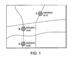
- Fig. 1 is an exemplary diagram illustrating displacement of a vehicle's present location
- Fig. 2 is an exemplary diagram illustrating links included in a vehicle's travel route
- Fig. 3 is an exemplary diagram illustrating displacement of a vehicle's present location
- Fig. 4 is an exemplary diagram illustrating links included in a vehicle's travel route
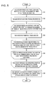
- Fig. 5 illustrates an exemplary travel time database generating method
- a travel time database generating device may physically, functionally, or conceptually include a present location database that may store information on the present location of a plurality of vehicles obtained during a predetermined period and a server.
- the controller may process the vehicle's present location information stored in the present location database, may calculate a link travel time as information for each link, may statistically process the calculated link travel time of each link; and may generate a travel time database that stores the link travel time after the statistical processing.
- the present location database may be information on the present location of vehicles sent every predetermined time period to for example, a center, such as an information center.
- the information may include stored present location information that an on-vehicle device mounted in a vehicle, such as, an automobile, a truck, a bus and/or a motorcycle accumulated during the predetermined period.
- the predetermined time period may be preset and may be set arbitrarily.
- the vehicle may be pre-registered by the center and may have a registration ID.
- the on-vehicle device may also or alternatively be pre-registered.
- the information center may physically, functionally, and/or conceptually include a communicator that may receive the present location information from the on-vehicle device and a memory.
- the memory may store the present location information received from the on-vehicle device and may include, for example, a semiconductor memory, a magnetic disk, and/or an optical disk.
- the on-vehicle device may be, for example, a vehicle navigation device with a wireless communication function or any other device that is provided with, for example, a present location detector and a transmitter.
- the present location detector may detect a present location using for example, a GPS (Global Positioning System), a geomagnetic sensor, a distance sensor, a steering sensor, a beacon sensor, and/or a gyro sensor.
- the transmitter may send to the information center every predetermined time period the present location information.
- the present location information may include vehicle identification information and/or a coordinate value that indicates a present location detected by the present location detector.
- the vehicle may be a taxi that belongs to a taxi company
- the information center may be a traffic control center in the taxi company.
- Each of the on-vehicle devices of a plurality of taxis of the taxi company may send the present location information every predetermined time period to the traffic control center.
- a traffic control server in the traffic control center may store each of the received taxis' present location information in a memory.
- the traffic control center may determine each of the taxis' traffic situations.
- Each of the stored taxis' present location information for example, may be used in the present location database.
- the vehicle may be a truck that belongs to a transportation company
- the information center may be a traffic control center in the transportation company.
- Each of the on-vehicle devices of a plurality of trucks of the transportation company may send present location information every predetermined time period to the traffic control center.
- a traffic control server in the traffic control center may store each of the received trucks' present location information in a memory.
- the traffic control center may determine each of the trucks' traffic situations and, as a result, update/determine a delivery status of each truckload.
- Each of the stored trucks' present location information in the memory may be used in the present location database.
- the vehicle may be a bus that belongs to a bus company
- the information center may be a traffic control center in the bus company.
- Each of the on-vehicle devices of a plurality of buses of the bus company may send present location information every predetermined time period to the traffic control center.
- a traffic control server in the traffic control center may store each of the received buses' present location information in a memory.
- the traffic control center may determine each of the route buses' traffic situation. Using each of the received buses' present location information and/or traffic situation as bus location system information, the traffic control center may, for example, display a coming bus's location on a display at a bus stop.
- Each of the stored buses' present location information in the memory may be used in the present location database.
- the server such as the server in the information center may physically, functionally, and/or conceptually include a memory and a controller.
- the memory may be a storage medium that stores map information including, for example, road information and/or search information.
- the controller may estimate a travel route between points through which a vehicle passes based on a displacement of the vehicle's present location, may calculate a link travel time of links included in the estimated travel route, and may statistically process the calculated link travel time of each link.
- each road may consist of a plurality of componential units called links.
- Each link may be separated and defined by, for example, an intersection, an intersection having more than three roads, a curve, and/or a point at which the road type changes.
- node refers to a point connecting two links.
- a node may be, for example, an intersection, an intersection having more than three roads, a curve, and/or a point at which the road type changes.
- the road information may include information on, for example, road intersections (including a fork and/or a T-junction), nodes, and links.
- Link data may include, for example, an identification number for link, a link ID, coordinates of starting and ending link points, and/or a distance from starting link point to ending link point.
- the server may calculate a congestion degree and/or a driving speed as link information on each link based on the link travel time of each link.
- the link information for each link stored in the travel time database may include, for example, a congestion degree and/or a driving speed as well as the link travel time.
- the travel time database may include change factors of the link information as well as the link information.
- the change factors may be, for example, a time factor, a calendar factor, a climate factor, and/or an incidental factor.
- the time factor may be a short time period (for example, about 15 minutes), a long time period (for example, about 1 hour), or other time periods with wider divisions (such as, for example, morning, afternoon, evening, night and/or midnight). Even if traveling the same link, its link travel time, congestion degree and/or driving speed may depend on the time period.
- Calendar factors may include, for example, a day of the week, a date and/or a season. Even if traveling the same link, its link travel time, congestion degree and/or driving speed may depend on a day of the week (for example, weekday or weekend days, the fifth, tenth, fifteenth, twentieth, twenty fifth, thirtieth days of a month, days in a successive holiday period, days after a successive holiday period, Bon holiday; New Year's holiday, and/or days in a summer vacation).
- Incidental factors may include, for example, accidents, a traffic restriction and/or an event such as a festival and/or a sports competition. Thus, even if traveling the same link, its link travel time, congestion degree and/or driving speed may depend on one or more incidental factors.
- a link travel time is calculated based on present location information e
- the exemplary methods may be implemented, for example, by one or more components of the above-described travel time database generating device.
- the exemplary structure of the above-described a travel time database generating device may be referenced in the description, it should be appreciated that the structure is exemplary and the exemplary method need not be limited by any of the above-described exemplary structure.
- Fig. 1 is a first exemplary diagram illustrating displacement of a vehicle's present location.
- vehicle ⁇ is represented traveling on a road on a map.
- An on-vehicle device of the vehicle ⁇ may send present location information, for example, about every 5 minutes (predetermined time period), and pass through point A, point B and point C consecutively.
- the point A, point B, and point C may be points at which the present location of the vehicle is detected.
- a date and a time shown at each point indicate when points were detected as the vehicle's present location.
- the controller of the server may, for example, estimate a travel route between 2 detected present locations of a particular vehicle, e.g., a travel route between point A and point B of the vehicle ⁇ .
- the controller may access map information stored in a memory; perform a route search, estimate the travel route, and identify the links that the vehicle ⁇ traveled on between point A and point B.
- nodes and links may be identified.
- small circles may represent nodes and big circles may represent point A and point B.
- Lines between each node may represent links, three digit numbers under each link may represent link ID, and numbers in parenthesis under each link ID may represent a distance from a starting point to an ending point of link, i.e., a link length (for example, in meters). Numbers above links including point A and point B may represent distance (for example, in meters) from a node to point A or point B.
- the controller may divide the travel time from point A to point B.
- the travel time may be divided, for example, in proportion to the link length of each link.
- the travel time from point A to point B is the same as the predetermined time period, that is, 5 minutes in this example.
- the link travel time for the link having ID 101 is 111.1 seconds and the link travel time for the link having ID 300 is 66.7 seconds. In this way, the travel times link ID 101 and link ID 300 are calculated at point A, for example at the time: 10:00 am.
- the travel times may not be calculated because, for example, their whole link lengths are not included in a distance range from point A to point B.
- the server may estimate a travel route from point A to point B and, in the same way as described above, calculate a travel time of links whose whole lengths are included in a distance range from point B to point C. Continuously, the same operation may be performed repeatedly for each distance range between points crossed every predetermined time period.
- the controller of the server may additionally or alternatively execute a statistical processing of the link travel times of the identical link in the identical time period.
- Fig. 3 is an exemplary diagram illustrating displacement of a vehicle's present location
- Fig. 4 is an exemplary diagram illustrating links included in a travel route
- the link travel time may be similarly calculated.
- the time period may be accordingly set, for example, as 5 minutes period, 30 minutes period, or 1 hour period.
- the server may generate a travel time database by executing a statistical processing of the calculated link travel time by processing the present location information in the identical time period.
- the time period is set as 15 minutes.
- 10:00 am -11:00 am may be divided into 4 time periods: 10:00 am -10:15 am, 10:15 am -10:30 am, 10:30 am -10:45 am and 10:45 am -11:00 am.
- the present location information for vehicle ⁇ during 10:00 am -10:15 am is included in the identical time period as that for vehicle ⁇ , described above.
- vehicle ⁇ is represented traveling on a road on a map.
- An on-vehicle device of the vehicle ⁇ may send present location information every predetermined time period, for example, every 5 minutes, and pass through point A', point B' and point C' consecutively.
- the point A', point B', and point C' may be points at which the present location of the vehicle is detected.
- a date and a time shown at each point indicate when points were detected as the vehicle's present location.
- the present location information in the example shown in Fig. 3 is present location information included in the identical time period (10:00 am - 10: 15 am) to that of the example shown in Fig. 1.
- the server may estimate a travel route between point A' and point B', similarly to the exemplary implementation shown in Fig. 1.
- nodes and links may be identified.
- Fig. 4 is the type of diagram as Fig. 2, only shown with respect to vehicle ⁇ .
- the controller may divide the travel time in proportion to the link length of each link. As a result the, the distance from point A' to point B' may be calculated, the distance from point A' to point B' may be divided by the travel time from point A' to point B' (e.g., 5 min). Accordingly, the average travel speed from point A' to point B' may be calculated.
- link ID 101 when the travel time from point A' to point B' is divided in proportion to the link length of each link, the travel time for link ID 101 is 91.8 seconds, the travel time for link ID 300 is 55.1 seconds, and the travel time for link ID 301 is 101.0 seconds. In such a way, link ID 101, link ID 300 and link ID 301 travel times may be calculated at point A, at the time: 10:01 am.
- the link travel time in the example shown in Fig. 1 and the link travel time in the example shown in Fig. 3 because their time period as a factor is identical, they may be statistically processed. For example, an average value of the link travel times may be calculated by the statistical processing, wherein the average travel time for link ID 101 is 101.5 seconds, the average travel time for link ID 300 is 60.9 seconds, and the average travel time for link ID 301 is 101.0 seconds. It should be noted that because there is only one sample for link ID 301, the average link travel time is based only on that sample, shown in Fig. 3.
- link ID 101 and link ID 300 when compared with the example shown in Fig. 1, their link travel times are shorter and the roads corresponding to those links may be considered less busy. Accordingly, by increasing the number of object samples of the statistical processing, detailed and highly accurate information on for example, travel time of each link may be obtained based on the present location information on a traveling vehicle every determined time period.
- the server may start operations by accessing the present location database.
- the server starts the first loop and repeats the loop the number of times of all travel information (step S1). That is, the server repeats the operations of steps S2-S6, described below, for the present location information of all travel information.
- the present location database the present location information of enough samples to execute the statistical processing is stored.
- the present location information is obtained present location information obtained during the traveling of a number of participating vehicles (such as for example vehicles ⁇ and ⁇ ).
- the server then obtains the one-travel information for one participating vehicle from the present location database (step S2).
- one-travel information is the present location information that an on-vehicle device mounted in the participating vehicle sends every predetermined time period from a start-up to a stop of an engine of the vehicle, i.e., from a departure to a destination of the vehicle. If the vehicle visits several destinations in a day, a plurality of travel information may be stored as, for example, one-day information.
- the present location information stored in the present location database may be one-travel information, one-day information; however it may preferably be information during a predetermined time period, for example, as long as several days.
- the stored travel information includes a plurality of travel information on each of the plurality of vehicles. For example, if a plurality of travel information on each of a vehicle ⁇ , a vehicle ⁇ , a vehicle ⁇ ,..., and a vehicle ⁇ is stored in the present location database, the first time step S2 is executed in the loop, the first travel information of the vehicle ⁇ may be obtained.
- the server starts a second loop and repeats the loop the time of combinations for the obtained location information, that is, the present location information in one-travel information obtained from the present location database (step S3).
- the server repeats the operations described below, for each combinations of the present location information, starting with combinations of the present location information on point A and point B, combinations of the present location information on point B and point C, combinations of the present location information on point C and point D,..., and so on up to combinations of the present location information on point N-1 and point N.
- the sever may estimate a travel route (step S4).
- the server may search for a route by accessing the map information stored in the memory, estimate a travel route between point A and point B, and identify links the vehicle ⁇ travels on.
- the server next allocates time between the time points at which location information is obtained, that is, the travel time between points at which the present location information is obtained, based on a link length of each link included in the travel route (step S5).
- the server may allocate the travel time between point A and point B based on a link length of each link included in the estimated travel route. Accordingly, the travel time of each link at the time point of point A may be calculated.
- the second loop ends (step S6).
- another one-travel information is obtained, and the second loop starts again. If a plurality of the one-travel information for one vehicle is stored in the present location database, each of the one-travel information for that vehicle may be obtained consecutively and the second loop operation may be performed on each one-travel information. After finishing the second loop operation for all travel information on the current vehicle, one-travel information on a next vehicle is obtained, and the second loop starts again.
- the server repeats the operations of obtaining one-travel information and starting second loop for all of the travel information.
- the first loop ends (step S7). In other words, when for all travel information of all vehicles, the travel times of each link included in the travel route has been calculated, the first loop ends.
- the server calculates statistical values of a plurality of the obtained link travel times of each link and ends the process (step S8).
- the controller may statistically process a plurality of the obtained travel times of each link and calculate link travel times as statistical values for each link.
- the statistical processing of the travel times may include any kind of statistical process, for example, calculating an average value of the plurality of the travel times for each link, excluding abnormal values. Accordingly, a travel time database storing link travel times as statistic values may be generated.
- the travel time database in a navigation device for vehicles may be available as statistical traffic information when executing navigation process, such as a route search process to a destination.
- a calculated congestion degree and/or a travel speed of each link based on the link travel time of each link may be stored in the travel time database.
- the travel time database may be installed in a traffic information center to transmit a link travel time, a congestion degree and/or a travel speed of each link to navigation devices for vehicles.
- the travel time database may provide a link travel time, a congestion degree and/or a travel speed of each link with a server that is installed in a traffic information center and executes navigation processing.
- the travel time database may be available for a GIS (Geographic Information System) and/or an electronic map as a system that integrates, analyzes a variety of information and/or clearly draws a map based on a location and/or a place by linking letters, numbers and/or images with a map in a computer.
- GIS Geographic Information System
- the travel time database generating device may estimate a vehicle's travel route based on the vehicle's present location information sent every predetermined time period, calculate a link travel time of links included in the estimated travel route and thereby generate a travel time database. Accordingly, a mounted on-vehicle device does not need to send to a center the travel time of links on which a vehicle travels. Instead, it only sends the present location data every predetermined time period. Therefore, the number of transmissions and transmission data volume may be reduced, and a travel time database with high accuracy may be generated based on obtained information at a lower transmission cost.
- a navigation device for vehicles a server installed in a traffic information center, or a server of a geographic information system and an electronic map providing system may execute online or offline processing of the present location information and calculate the link travel time of each link.
- a controller allocates a travel time between 2 present locations based on a link length of each link included in a travel route
- a hypothetical link length may be calculated from its real link length in accordance with road type.
- a travel time may be allocated based on the hypothetical link length of each link.
- the road type may take into consideration, for example, an expressway and/or a general road, and presence or absence of traffic signals and/or railroad crossings.
- a hypothetical link length value may equal its real link length multiplied by 0.5 as a coefficient in accordance with a road type.
- the hypothetical link length for the expressway link may be 400 m.
- a hypothetical link length value may equal its real link length multiplied by 1.0 as a coefficient in accordance with a road type.
- a hypothetical link length value may equal its real link length multiplied by 0.9 as a coefficient in accordance with a road type.
- a hypothetical link length value may equal its real link length multiplied by 1.5 as a coefficient in accordance with a road type.
- 120 may be added to a real link length or previously determined hypothetical link length of the link to obtain the hypothetical link length.
- the hypothetical link length may be calculated from its real link length in accordance with the road type and the travel time may be allocated based on the hypothetical link length of each link.
- the travel time may be allocated based on the hypothetical link length of each link.
Landscapes
- Engineering & Computer Science (AREA)
- Radar, Positioning & Navigation (AREA)
- Remote Sensing (AREA)
- Physics & Mathematics (AREA)
- General Physics & Mathematics (AREA)
- Chemical & Material Sciences (AREA)
- Analytical Chemistry (AREA)
- Automation & Control Theory (AREA)
- Traffic Control Systems (AREA)
- Navigation (AREA)
- Instructional Devices (AREA)
Abstract
Description
- The disclosure of
Japanese Patent Application No. 2005-180975 filed on June 21, 2005 - Related technical fields include travel time database generating devices, methods, and programs.
- Conventional navigation devices search for an optimum route from a set departure point to a set destination based on road map information and display the route on a display unit. During the search, the optimum route may be determined such that it has a shortest distance and/or shortest required time from a departure point to a destination.
- In order that the optimum route may be set in view of an actual volume of traffic and/or a congestion state, some conventional navigation devices consider traffic information. For example, every time a vehicle passes through a predetermined road section, the vehicle may send to a traffic information center information the amount of time required to pass through the predetermined road section. Based on this information, the traffic information center may estimate a state of traffic on the road section by statistically processing the received information from a plurality of vehicles. A searchable traffic database may be created including the estimated sate of traffic on various roads. See, for example,
Japanese Unexamined Patent Application Publication No. 2004-20288 - According to the above conventional systems, the information on the time required to pass through the predetermined road section(s) is sent every time a participating vehicle passes through a predetermined road section. Thus, the number of transmissions from the vehicles may be large and duplicative. Also, for each transmission, because a variety of information may be sent, the transmission cost may be large. It might reduce the number of transmissions per vehicle, for example, to send the information for that vehicle together at predetermined times. However, in such a case, because the volume of information for such a transmission is larger, the time for every transmission may be longer and the transmission cost may not be substantially reduced. Furthermore, a required time for processing may be increased.
- At least, in view of one or more the above-described deficiencies in conventional systems, a travel time database generating device, method, and program that may reduce transmission volumes and/or processing times may be provided.
- Various exemplary implementations of the principles described herein provide travel time database generating systems, methods, and programs that may receive a vehicle's present location information and may calculate a link travel time for each link included in the present location information. The systems, methods, and programs may generate a travel time database including link travel times by estimating a travel route between the vehicle's present locations detected every predetermined time period and calculating a link travel time of links included in the estimated travel route.
- Exemplary implementations will now be described with reference to the accompanying drawings, wherein:
- Fig. 1 is an exemplary diagram illustrating displacement of a vehicle's present location;
- Fig. 2 is an exemplary diagram illustrating links included in a vehicle's travel route;
- Fig. 3 is an exemplary diagram illustrating displacement of a vehicle's present location;
- Fig. 4 is an exemplary diagram illustrating links included in a vehicle's travel route;
- Fig. 5 illustrates an exemplary travel time database generating method;
- According to various exemplary implementations of the principles described herein, a travel time database generating device may physically, functionally, or conceptually include a present location database that may store information on the present location of a plurality of vehicles obtained during a predetermined period and a server. The controller may process the vehicle's present location information stored in the present location database, may calculate a link travel time as information for each link, may statistically process the calculated link travel time of each link; and may generate a travel time database that stores the link travel time after the statistical processing.
- The present location database may be information on the present location of vehicles sent every predetermined time period to for example, a center, such as an information center. The information may include stored present location information that an on-vehicle device mounted in a vehicle, such as, an automobile, a truck, a bus and/or a motorcycle accumulated during the predetermined period. The predetermined time period may be preset and may be set arbitrarily.
- In such a case, the vehicle may be pre-registered by the center and may have a registration ID. The on-vehicle device may also or alternatively be pre-registered. The information center may physically, functionally, and/or conceptually include a communicator that may receive the present location information from the on-vehicle device and a memory. The memory may store the present location information received from the on-vehicle device and may include, for example, a semiconductor memory, a magnetic disk, and/or an optical disk.
- The on-vehicle device may be, for example, a vehicle navigation device with a wireless communication function or any other device that is provided with, for example, a present location detector and a transmitter. The present location detector may detect a present location using for example, a GPS (Global Positioning System), a geomagnetic sensor, a distance sensor, a steering sensor, a beacon sensor, and/or a gyro sensor. The transmitter may send to the information center every predetermined time period the present location information. The present location information may include vehicle identification information and/or a coordinate value that indicates a present location detected by the present location detector.
- For example, the vehicle may be a taxi that belongs to a taxi company, and the information center may be a traffic control center in the taxi company. Each of the on-vehicle devices of a plurality of taxis of the taxi company may send the present location information every predetermined time period to the traffic control center. A traffic control server in the traffic control center may store each of the received taxis' present location information in a memory. Thus, the traffic control center may determine each of the taxis' traffic situations. Each of the stored taxis' present location information, for example, may be used in the present location database.
- [0018] As another example, the vehicle may be a truck that belongs to a transportation company, and the information center may be a traffic control center in the transportation company. Each of the on-vehicle devices of a plurality of trucks of the transportation company may send present location information every predetermined time period to the traffic control center. A traffic control server in the traffic control center may store each of the received trucks' present location information in a memory. Thus, the traffic control center may determine each of the trucks' traffic situations and, as a result, update/determine a delivery status of each truckload. Each of the stored trucks' present location information in the memory may be used in the present location database.
- As another example, the vehicle may be a bus that belongs to a bus company, and the information center may be a traffic control center in the bus company. Each of the on-vehicle devices of a plurality of buses of the bus company may send present location information every predetermined time period to the traffic control center. A traffic control server in the traffic control center may store each of the received buses' present location information in a memory. Thus, the traffic control center may determine each of the route buses' traffic situation. Using each of the received buses' present location information and/or traffic situation as bus location system information, the traffic control center may, for example, display a coming bus's location on a display at a bus stop. Each of the stored buses' present location information in the memory may be used in the present location database.
- The server, such as the server in the information center may physically, functionally, and/or conceptually include a memory and a controller. The memory may be a storage medium that stores map information including, for example, road information and/or search information. The controller may estimate a travel route between points through which a vehicle passes based on a displacement of the vehicle's present location, may calculate a link travel time of links included in the estimated travel route, and may statistically process the calculated link travel time of each link.
- As used herein, the term "link" refers to, for example, a road or portion of a road. For example, according to one type of road data, each road may consist of a plurality of componential units called links. Each link may be separated and defined by, for example, an intersection, an intersection having more than three roads, a curve, and/or a point at which the road type changes. As used herein the term "node" refers to a point connecting two links. A node may be, for example, an intersection, an intersection having more than three roads, a curve, and/or a point at which the road type changes.
- The road information may include information on, for example, road intersections (including a fork and/or a T-junction), nodes, and links. Link data may include, for example, an identification number for link, a link ID, coordinates of starting and ending link points, and/or a distance from starting link point to ending link point.
- The server may calculate a congestion degree and/or a driving speed as link information on each link based on the link travel time of each link. In other words, the link information for each link stored in the travel time database may include, for example, a congestion degree and/or a driving speed as well as the link travel time. Furthermore, the travel time database may include change factors of the link information as well as the link information.
- The change factors may be, for example, a time factor, a calendar factor, a climate factor, and/or an incidental factor. For example, the time factor may be a short time period (for example, about 15 minutes), a long time period (for example, about 1 hour), or other time periods with wider divisions (such as, for example, morning, afternoon, evening, night and/or midnight). Even if traveling the same link, its link travel time, congestion degree and/or driving speed may depend on the time period.
- Calendar factors may include, for example, a day of the week, a date and/or a season. Even if traveling the same link, its link travel time, congestion degree and/or driving speed may depend on a day of the week (for example, weekday or weekend days, the fifth, tenth, fifteenth, twentieth, twenty fifth, thirtieth days of a month, days in a successive holiday period, days after a successive holiday period, Bon holiday; New Year's holiday, and/or days in a summer vacation).
Incidental factors may include, for example, accidents, a traffic restriction and/or an event such as a festival and/or a sports competition. Thus, even if traveling the same link, its link travel time, congestion degree and/or driving speed may depend on one or more incidental factors. - Hereinafter, an exemplary database generating methods will be described with reference to Figs. 1-5. For ease of explanation as operation wherein a link travel time is calculated based on present location information e will be described. The exemplary methods may be implemented, for example, by one or more components of the above-described travel time database generating device. However, even though the exemplary structure of the above-described a travel time database generating device may be referenced in the description, it should be appreciated that the structure is exemplary and the exemplary method need not be limited by any of the above-described exemplary structure.
- Fig. 1 is a first exemplary diagram illustrating displacement of a vehicle's present location. As shown in Fig. 1, vehicle α is represented traveling on a road on a map. An on-vehicle device of the vehicle α may send present location information, for example, about every 5 minutes (predetermined time period), and pass through point A, point B and point C consecutively. The point A, point B, and point C may be points at which the present location of the vehicle is detected. In Fig. 1, a date and a time shown at each point indicate when points were detected as the vehicle's present location.
- The controller of the server may, for example, estimate a travel route between 2 detected present locations of a particular vehicle, e.g., a travel route between point A and point B of the vehicle α. In such a case, the controller may access map information stored in a memory; perform a route search, estimate the travel route, and identify the links that the vehicle α traveled on between point A and point B. In this way, as shown in Fig. 2., nodes and links may be identified. In Fig. 2, small circles may represent nodes and big circles may represent point A and point B. Lines between each node may represent links, three digit numbers under each link may represent link ID, and numbers in parenthesis under each link ID may represent a distance from a starting point to an ending point of link, i.e., a link length (for example, in meters). Numbers above links including point A and point B may represent distance (for example, in meters) from a node to point A or point B.
- The controller may divide the travel time from point A to point B. The travel time may be divided, for example, in proportion to the link length of each link. In the example of Fig. 2, the distance in meters from point A to point B may be calculated by the following formula (1):

The travel time from point A to point B is the same as the predetermined time period, that is, 5 minutes in this example. Accordingly, the average travel speed from point A to point B is calculated by the following formula (2):
Based on the above calculations, when the travel time from point A to point B is divided in proportion to the link length of each link, for example, the link travel time for thelink having ID 101 is 111.1 seconds and the link travel time for thelink having ID 300 is 66.7 seconds. In this way, the travel times linkID 101 andlink ID 300 are calculated at point A, for example at the time: 10:00 am. - For
link ID 100 andlink ID 301, the travel times may not be calculated because, for example, their whole link lengths are not included in a distance range from point A to point B. - Next, the server may estimate a travel route from point A to point B and, in the same way as described above, calculate a travel time of links whose whole lengths are included in a distance range from point B to point C. Continuously, the same operation may be performed repeatedly for each distance range between points crossed every predetermined time period.
- Next, the controller of the server may additionally or alternatively execute a statistical processing of the link travel times of the identical link in the identical time period. Fig. 3 is an exemplary diagram illustrating displacement of a vehicle's present location and Fig. 4 is an exemplary diagram illustrating links included in a travel route
- Based on present location information in the identical time period to the one in the exemplary implementation shown in the Fig. 1, and furthermore the present location information sent by a different vehicle β from the vehicle α, the link travel time may be similarly calculated. The time period may be accordingly set, for example, as 5 minutes period, 30 minutes period, or 1 hour period. The server may generate a travel time database by executing a statistical processing of the calculated link travel time by processing the present location information in the identical time period. In this example, the time period is set as 15 minutes. For example, 10:00 am -11:00 am may be divided into 4 time periods: 10:00 am -10:15 am, 10:15 am -10:30 am, 10:30 am -10:45 am and 10:45 am -11:00 am. Accordingly, the present location information for vehicle β during 10:00 am -10:15 am is included in the identical time period as that for vehicle α, described above.
- As shown in Fig. 3, vehicle β is represented traveling on a road on a map. An on-vehicle device of the vehicle β may send present location information every predetermined time period, for example, every 5 minutes, and pass through point A', point B' and point C' consecutively. The point A', point B', and point C' may be points at which the present location of the vehicle is detected. In Fig. 3, a date and a time shown at each point indicate when points were detected as the vehicle's present location. Considering the date and time, it may be noted that the present location information in the example shown in Fig. 3 is present location information included in the identical time period (10:00 am - 10: 15 am) to that of the example shown in Fig. 1.
- The server may estimate a travel route between point A' and point B', similarly to the exemplary implementation shown in Fig. 1. As shown in Fig. 4, nodes and links may be identified. Fig. 4 is the type of diagram as Fig. 2, only shown with respect to vehicle β. As discussed above, the controller may divide the travel time in proportion to the link length of each link. As a result the, the distance from point A' to point B' may be calculated, the distance from point A' to point B' may be divided by the travel time from point A' to point B' (e.g., 5 min). Accordingly, the average travel speed from point A' to point B' may be calculated. Based on the above, when the travel time from point A' to point B' is divided in proportion to the link length of each link, the travel time for
link ID 101 is 91.8 seconds, the travel time forlink ID 300 is 55.1 seconds, and the travel time forlink ID 301 is 101.0 seconds. In such a way,link ID 101,link ID 300 andlink ID 301 travel times may be calculated at point A, at the time: 10:01 am. - Regarding the link travel time in the example shown in Fig. 1 and the link travel time in the example shown in Fig. 3, because their time period as a factor is identical, they may be statistically processed. For example, an average value of the link travel times may be calculated by the statistical processing, wherein the average travel time for
link ID 101 is 101.5 seconds, the average travel time forlink ID 300 is 60.9 seconds, and the average travel time forlink ID 301 is 101.0 seconds. It should be noted that because there is only one sample forlink ID 301, the average link travel time is based only on that sample, shown in Fig. 3. - As such a result of the statistical processing, it will be noted that
link ID 101 andlink ID 300, when compared with the example shown in Fig. 1, their link travel times are shorter and the roads corresponding to those links may be considered less busy. Accordingly, by increasing the number of object samples of the statistical processing, detailed and highly accurate information on for example, travel time of each link may be obtained based on the present location information on a traveling vehicle every determined time period. - Next, the above travel time database generating method will be summarized with reference to Fig. 5. First, for example, the server may start operations by accessing the present location database. As shown in Fig. 5, the server starts the first loop and repeats the loop the number of times of all travel information (step S1). That is, the server repeats the operations of steps S2-S6, described below, for the present location information of all travel information. In the present location database, the present location information of enough samples to execute the statistical processing is stored. The present location information is obtained present location information obtained during the traveling of a number of participating vehicles (such as for example vehicles α and β).
- The server then obtains the one-travel information for one participating vehicle from the present location database (step S2). As used herein "one-travel information" is the present location information that an on-vehicle device mounted in the participating vehicle sends every predetermined time period from a start-up to a stop of an engine of the vehicle, i.e., from a departure to a destination of the vehicle. If the vehicle visits several destinations in a day, a plurality of travel information may be stored as, for example, one-day information. The present location information stored in the present location database may be one-travel information, one-day information; however it may preferably be information during a predetermined time period, for example, as long as several days. Because there is a plurality of participating vehicles sending the present location information, the stored travel information includes a plurality of travel information on each of the plurality of vehicles. For example, if a plurality of travel information on each of a vehicle α, a vehicle β, a vehicle γ,..., and a vehicle ω is stored in the present location database, the first time step S2 is executed in the loop, the first travel information of the vehicle α may be obtained.
- Next, the server starts a second loop and repeats the loop the time of combinations for the obtained location information, that is, the present location information in one-travel information obtained from the present location database (step S3). For example, if the obtained present location information in the first travel information of the vehicle α as one-travel information is present location information of point A, point B, point C, point D, ..., point N-1 and point N, the server repeats the operations described below, for each combinations of the present location information, starting with combinations of the present location information on point A and point B, combinations of the present location information on point B and point C, combinations of the present location information on point C and point D,..., and so on up to combinations of the present location information on point N-1 and point N.
- Then, the sever may estimate a travel route (step S4). As described in the example shown in Fig. 1, the server may search for a route by accessing the map information stored in the memory, estimate a travel route between point A and point B, and identify links the vehicle α travels on.
- The server next allocates time between the time points at which location information is obtained, that is, the travel time between points at which the present location information is obtained, based on a link length of each link included in the travel route (step S5). As described in the example shown in Fig. 1, the server may allocate the travel time between point A and point B based on a link length of each link included in the estimated travel route. Accordingly, the travel time of each link at the time point of point A may be calculated.
- When the server has repeated the above-described operations for each combination of the obtained location information of the present location information included in one-travel information obtained from the present location database, the second loop ends (step S6). Next, another one-travel information is obtained, and the second loop starts again. If a plurality of the one-travel information for one vehicle is stored in the present location database, each of the one-travel information for that vehicle may be obtained consecutively and the second loop operation may be performed on each one-travel information. After finishing the second loop operation for all travel information on the current vehicle, one-travel information on a next vehicle is obtained, and the second loop starts again.
- The server repeats the operations of obtaining one-travel information and starting second loop for all of the travel information. When the present location information on all travel information has been processed, the first loop ends (step S7). In other words, when for all travel information of all vehicles, the travel times of each link included in the travel route has been calculated, the first loop ends.
- Next, the server calculates statistical values of a plurality of the obtained link travel times of each link and ends the process (step S8). For example, as described above, the controller may statistically process a plurality of the obtained travel times of each link and calculate link travel times as statistical values for each link. The statistical processing of the travel times may include any kind of statistical process, for example, calculating an average value of the plurality of the travel times for each link, excluding abnormal values. Accordingly, a travel time database storing link travel times as statistic values may be generated.
- The travel time database in a navigation device for vehicles may be available as statistical traffic information when executing navigation process, such as a route search process to a destination. In such a case, a calculated congestion degree and/or a travel speed of each link based on the link travel time of each link may be stored in the travel time database. For example, the travel time database may be installed in a traffic information center to transmit a link travel time, a congestion degree and/or a travel speed of each link to navigation devices for vehicles. The travel time database may provide a link travel time, a congestion degree and/or a travel speed of each link with a server that is installed in a traffic information center and executes navigation processing. The travel time database may be available for a GIS (Geographic Information System) and/or an electronic map as a system that integrates, analyzes a variety of information and/or clearly draws a map based on a location and/or a place by linking letters, numbers and/or images with a map in a computer.
- For example, the travel time database generating device may estimate a vehicle's travel route based on the vehicle's present location information sent every predetermined time period, calculate a link travel time of links included in the estimated travel route and thereby generate a travel time database. Accordingly, a mounted on-vehicle device does not need to send to a center the travel time of links on which a vehicle travels. Instead, it only sends the present location data every predetermined time period. Therefore, the number of transmissions and transmission data volume may be reduced, and a travel time database with high accuracy may be generated based on obtained information at a lower transmission cost.
- In the above examples, only a case in which a server processes present location information and calculates a link travel time of each link is described. However, a navigation device for vehicles, a server installed in a traffic information center, or a server of a geographic information system and an electronic map providing system may execute online or offline processing of the present location information and calculate the link travel time of each link.
- In the above examples, only a case in which a mounted on-vehicle device sends coordinates indicating present locations to an information center is described. However, instead of coordinates, a link ID or a distance from an edge of link may be sent to the information center.
- In the above examples, only a case in which a mounted on-vehicle device sends information every predetermined time period to an information center is described. However, instead of every predetermined time period, the information may be sent to the center at predetermined times.
- Next, another example will be described. Explanations are omitted of operations and/or effects that are similar to the above described examples.
- When a controller allocates a travel time between 2 present locations based on a link length of each link included in a travel route, a hypothetical link length may be calculated from its real link length in accordance with road type. As a result, a travel time may be allocated based on the hypothetical link length of each link.
- Herein, the road type may take into consideration, for example, an expressway and/or a general road, and presence or absence of traffic signals and/or railroad crossings.
- For example, when a road type of a link is an expressway, a hypothetical link length value may equal its real link length multiplied by 0.5 as a coefficient in accordance with a road type. Thus, if the real link length of the expressway link is 800 m, the hypothetical link length for the expressway link may be 400 m. When the road type of a link is a general double-lane road, a hypothetical link length value may equal its real link length multiplied by 1.0 as a coefficient in accordance with a road type.
- When the road type of a link is a general 4 or more-lane road, a hypothetical link length value may equal its real link length multiplied by 0.9 as a coefficient in accordance with a road type. When the road type of link is a general road without centerline, a hypothetical link length value may equal its real link length multiplied by 1.5 as a coefficient in accordance with a road type. Furthermore, in any of the above examples, when there is a traffic signal or a railroad crossing at an edge of a link, 120 may be added to a real link length or previously determined hypothetical link length of the link to obtain the hypothetical link length.
- In the above example, the hypothetical link length may be calculated from its real link length in accordance with the road type and the travel time may be allocated based on the hypothetical link length of each link. Thus, a more accurate travel time may be calculated.
- While various features have been described in conjunction with the examples outlined above, various alternatives, modifications, variations, and/or improvements of those features and/or examples may be possible. Accordingly, the examples, as set forth above, are intended to be illustrative. Various changes may be made without departing from the broad spirit and scope of the underlying principles.
It is explicitly stated that all features disclosed in the description and/or the claims are intended to be disclosed separately and independently from each other for the purpose of original disclosure as well as for the purpose of restricting the claimed invention independent of the composition of the features in the embodiments and/or the claims. It is explicitly stated that all value ranges or indications of groups of entities disclose every possible intermediate value or intermediate entity for the purpose of original disclosure as well as for the purpose of restricting the claimed invention, in particular as limits of value ranges.
Claims (10)
- A travel time database generating device, comprising a controller that:receives a vehicle's present location information including the vehicle's present locations detected every predetermined time period;calculates a link travel time for each link; andgenerates a travel time database including link travel times by:estimating a travel route between the vehicle's present locations detected every predetermined time period; andcalculating a link travel time of links included in the estimated travel route.
- The travel time database generating device of claim 1, wherein the controller statistically processes the calculated link travel time of each link.
- The travel time database generating device of one of claims 1 or 2, further comprising a memory that stores a present location database that stores information on the present location of a plurality of vehicles obtained during the predetermined time period.
- The travel time database generating device of one of claims 1 to 3, wherein the controller:estimates the travel route between two consecutively detected present locations of the vehicle by accessing map information and performing a route search; andidentifies links which the vehicle traveled on.
- The travel time database generating device of one of claims 1 to 4, wherein the controller calculates a link travel time of each link by allocating the travel time between consecutively detected present locations based on a link length of each link included in the travel route.
- The travel time database generating device of one of claims 2 to 5, wherein the controller statistically processes link travel times for identical links in identical time periods.
- The travel time database generating device of claim 5, wherein the link length of each link is an actual link length.
- The travel time database generating device of claim 5, wherein the link length of each link is a value that equals an actual link length multiplied by a coefficient, the coefficient for each link based on a respective road type of each link.
- An information server, comprising the travel time database generating device of claim 1.
- A travel time database generating method, comprising:receiving a vehicle's present location information including the vehicle's present locations detected every predetermined time period;calculating a link travel time for each link; andgenerating a travel time database including link travel times by:estimating a travel route between the vehicle's present locations detected every predetermined time period; andcalculating a link travel time of links included in the estimated travel route.
Applications Claiming Priority (1)
| Application Number | Priority Date | Filing Date | Title |
|---|---|---|---|
| JP2005180975A JP2007004290A (en) | 2005-06-21 | 2005-06-21 | Travel time database creation device |
Publications (1)
| Publication Number | Publication Date |
|---|---|
| EP1736735A1 true EP1736735A1 (en) | 2006-12-27 |
Family
ID=36950259
Family Applications (1)
| Application Number | Title | Priority Date | Filing Date |
|---|---|---|---|
| EP06012649A Withdrawn EP1736735A1 (en) | 2005-06-21 | 2006-06-20 | Travel time database generating device and method |
Country Status (4)
| Country | Link |
|---|---|
| US (1) | US20070001873A1 (en) |
| EP (1) | EP1736735A1 (en) |
| JP (1) | JP2007004290A (en) |
| CN (1) | CN1884973A (en) |
Cited By (3)
| Publication number | Priority date | Publication date | Assignee | Title |
|---|---|---|---|---|
| GB2480264A (en) * | 2010-05-10 | 2011-11-16 | Thales Holdings Uk Plc | Telemetry apparatus and method for finding the most likely path taken by a vehicle |
| WO2012104393A1 (en) * | 2011-02-03 | 2012-08-09 | Tomtom Development Germany Gmbh | Method of generating expected average speeds of travel |
| CN106846807A (en) * | 2017-03-09 | 2017-06-13 | 北京公共交通控股(集团)有限公司 | A kind of public transport road chain speed determines method and device |
Families Citing this family (47)
| Publication number | Priority date | Publication date | Assignee | Title |
|---|---|---|---|---|
| US8577594B2 (en) * | 2006-10-25 | 2013-11-05 | Motorola Mobility Llc | Apparatus and method for route navigation of multiple destinations |
| JP2008186082A (en) * | 2007-01-26 | 2008-08-14 | Toyota Motor Corp | Information creation system |
| JP4491472B2 (en) * | 2007-03-27 | 2010-06-30 | 日立オートモティブシステムズ株式会社 | Traffic information system |
| US8892112B2 (en) | 2011-07-21 | 2014-11-18 | At&T Mobility Ii Llc | Selection of a radio access bearer resource based on radio access bearer resource historical information |
| US8326319B2 (en) | 2009-01-23 | 2012-12-04 | At&T Mobility Ii Llc | Compensation of propagation delays of wireless signals |
| DE112010001585T5 (en) | 2009-04-08 | 2012-10-11 | Komatsu Ltd. | Mobile body and system for managing mobile body inventory information |
| JP5424754B2 (en) * | 2009-07-13 | 2014-02-26 | 株式会社豊田中央研究所 | Link travel time calculation device and program |
| JP2011038794A (en) * | 2009-08-06 | 2011-02-24 | Sumitomo Electric System Solutions Co Ltd | Route search device, route search method, computer program, and map database |
| JP5544797B2 (en) * | 2009-09-10 | 2014-07-09 | 富士通株式会社 | Vehicle travel position data processing method, program, and vehicle travel position data processing apparatus |
| US8224349B2 (en) | 2010-02-25 | 2012-07-17 | At&T Mobility Ii Llc | Timed fingerprint locating in wireless networks |
| US8254959B2 (en) | 2010-02-25 | 2012-08-28 | At&T Mobility Ii Llc | Timed fingerprint locating for idle-state user equipment in wireless networks |
| US9053513B2 (en) | 2010-02-25 | 2015-06-09 | At&T Mobility Ii Llc | Fraud analysis for a location aware transaction |
| US9008684B2 (en) | 2010-02-25 | 2015-04-14 | At&T Mobility Ii Llc | Sharing timed fingerprint location information |
| US9196157B2 (en) | 2010-02-25 | 2015-11-24 | AT&T Mobolity II LLC | Transportation analytics employing timed fingerprint location information |
| US10527448B2 (en) * | 2010-03-24 | 2020-01-07 | Telenav, Inc. | Navigation system with traffic estimation using pipeline scheme mechanism and method of operation thereof |
| US8447328B2 (en) | 2010-08-27 | 2013-05-21 | At&T Mobility Ii Llc | Location estimation of a mobile device in a UMTS network |
| US9009629B2 (en) | 2010-12-01 | 2015-04-14 | At&T Mobility Ii Llc | Motion-based user interface feature subsets |
| US8612410B2 (en) | 2011-06-30 | 2013-12-17 | At&T Mobility Ii Llc | Dynamic content selection through timed fingerprint location data |
| US9462497B2 (en) | 2011-07-01 | 2016-10-04 | At&T Mobility Ii Llc | Subscriber data analysis and graphical rendering |
| CN102298839B (en) * | 2011-07-12 | 2013-08-28 | 北京世纪高通科技有限公司 | Method and device for computing OD travel time |
| US8761799B2 (en) | 2011-07-21 | 2014-06-24 | At&T Mobility Ii Llc | Location analytics employing timed fingerprint location information |
| US8897802B2 (en) | 2011-07-21 | 2014-11-25 | At&T Mobility Ii Llc | Selection of a radio access technology resource based on radio access technology resource historical information |
| US9519043B2 (en) | 2011-07-21 | 2016-12-13 | At&T Mobility Ii Llc | Estimating network based locating error in wireless networks |
| US8923134B2 (en) | 2011-08-29 | 2014-12-30 | At&T Mobility Ii Llc | Prioritizing network failure tickets using mobile location data |
| US8666390B2 (en) | 2011-08-29 | 2014-03-04 | At&T Mobility Ii Llc | Ticketing mobile call failures based on geolocated event data |
| US8762048B2 (en) | 2011-10-28 | 2014-06-24 | At&T Mobility Ii Llc | Automatic travel time and routing determinations in a wireless network |
| US8909247B2 (en) | 2011-11-08 | 2014-12-09 | At&T Mobility Ii Llc | Location based sharing of a network access credential |
| US9026133B2 (en) | 2011-11-28 | 2015-05-05 | At&T Mobility Ii Llc | Handset agent calibration for timing based locating systems |
| US8970432B2 (en) | 2011-11-28 | 2015-03-03 | At&T Mobility Ii Llc | Femtocell calibration for timing based locating systems |
| US8925104B2 (en) | 2012-04-13 | 2014-12-30 | At&T Mobility Ii Llc | Event driven permissive sharing of information |
| US8929827B2 (en) | 2012-06-04 | 2015-01-06 | At&T Mobility Ii Llc | Adaptive calibration of measurements for a wireless radio network |
| US9094929B2 (en) | 2012-06-12 | 2015-07-28 | At&T Mobility Ii Llc | Event tagging for mobile networks |
| US9326263B2 (en) | 2012-06-13 | 2016-04-26 | At&T Mobility Ii Llc | Site location determination using crowd sourced propagation delay and location data |
| US9046592B2 (en) | 2012-06-13 | 2015-06-02 | At&T Mobility Ii Llc | Timed fingerprint locating at user equipment |
| US8938258B2 (en) | 2012-06-14 | 2015-01-20 | At&T Mobility Ii Llc | Reference based location information for a wireless network |
| US8897805B2 (en) | 2012-06-15 | 2014-11-25 | At&T Intellectual Property I, L.P. | Geographic redundancy determination for time based location information in a wireless radio network |
| US9408174B2 (en) | 2012-06-19 | 2016-08-02 | At&T Mobility Ii Llc | Facilitation of timed fingerprint mobile device locating |
| US8892054B2 (en) | 2012-07-17 | 2014-11-18 | At&T Mobility Ii Llc | Facilitation of delay error correction in timing-based location systems |
| US9351223B2 (en) | 2012-07-25 | 2016-05-24 | At&T Mobility Ii Llc | Assignment of hierarchical cell structures employing geolocation techniques |
| CN103077610A (en) * | 2012-12-31 | 2013-05-01 | 清华大学 | Road trip time estimating method and system |
| CN103730005B (en) * | 2014-01-22 | 2017-01-18 | 广东欧珀移动通信有限公司 | Method and system for predicting journey running time |
| JP6324101B2 (en) * | 2014-02-21 | 2018-05-16 | 株式会社ゼンリン | TRAVEL TIME DATA PREPARATION DEVICE, TRAVEL TIME DATA PREPARATION METHOD, AND PROGRAM |
| KR101550731B1 (en) | 2014-03-11 | 2015-09-07 | 주식회사 트라콤 | Method And System For Producing Passage Velocities For Link Sections |
| US9351111B1 (en) | 2015-03-06 | 2016-05-24 | At&T Mobility Ii Llc | Access to mobile location related information |
| US9955802B2 (en) | 2015-04-08 | 2018-05-01 | Fasteners For Retail, Inc. | Divider with selectively securable track assembly |
| US10516972B1 (en) | 2018-06-01 | 2019-12-24 | At&T Intellectual Property I, L.P. | Employing an alternate identifier for subscription access to mobile location information |
| DE102019203739A1 (en) * | 2018-12-20 | 2020-06-25 | Continental Automotive Gmbh | Data storage, computing unit and method for performing a function of a vehicle |
Citations (3)
| Publication number | Priority date | Publication date | Assignee | Title |
|---|---|---|---|---|
| US5933100A (en) * | 1995-12-27 | 1999-08-03 | Mitsubishi Electric Information Technology Center America, Inc. | Automobile navigation system with dynamic traffic data |
| US20010029425A1 (en) * | 2000-03-17 | 2001-10-11 | David Myr | Real time vehicle guidance and traffic forecasting system |
| US20050107945A1 (en) * | 2002-01-15 | 2005-05-19 | Andreas Hiller | Method for determining a travel time |
Family Cites Families (9)
| Publication number | Priority date | Publication date | Assignee | Title |
|---|---|---|---|---|
| JP2669175B2 (en) * | 1991-03-28 | 1997-10-27 | 日産自動車株式会社 | In-vehicle map display device |
| US5272638A (en) * | 1991-05-31 | 1993-12-21 | Texas Instruments Incorporated | Systems and methods for planning the scheduling travel routes |
| JP3327264B2 (en) * | 1999-10-13 | 2002-09-24 | 株式会社デンソー | Route setting device and navigation device |
| US6480783B1 (en) * | 2000-03-17 | 2002-11-12 | Makor Issues And Rights Ltd. | Real time vehicle guidance and forecasting system under traffic jam conditions |
| US20040246147A1 (en) * | 2000-12-08 | 2004-12-09 | Von Grabe J. B. | Real time vehicular routing and traffic guidance system |
| FI114832B (en) * | 2001-11-05 | 2004-12-31 | Elisa Matkapuhelinpalvelut Oy | Procedures and systems for collecting traffic data |
| US7355528B2 (en) * | 2003-10-16 | 2008-04-08 | Hitachi, Ltd. | Traffic information providing system and car navigation system |
| JP2005134427A (en) * | 2003-10-28 | 2005-05-26 | Pioneer Electronic Corp | Traffic condition notifying device, system thereof, method thereof, program thereof, and recording medium recording the program |
| US7026958B2 (en) * | 2003-11-07 | 2006-04-11 | The Boeing Company | Method and system of utilizing satellites to transmit traffic congestion information to vehicles |
-
2005
- 2005-06-21 JP JP2005180975A patent/JP2007004290A/en active Pending
-
2006
- 2006-06-02 US US11/445,147 patent/US20070001873A1/en not_active Abandoned
- 2006-06-16 CN CNA2006100928650A patent/CN1884973A/en active Pending
- 2006-06-20 EP EP06012649A patent/EP1736735A1/en not_active Withdrawn
Patent Citations (3)
| Publication number | Priority date | Publication date | Assignee | Title |
|---|---|---|---|---|
| US5933100A (en) * | 1995-12-27 | 1999-08-03 | Mitsubishi Electric Information Technology Center America, Inc. | Automobile navigation system with dynamic traffic data |
| US20010029425A1 (en) * | 2000-03-17 | 2001-10-11 | David Myr | Real time vehicle guidance and traffic forecasting system |
| US20050107945A1 (en) * | 2002-01-15 | 2005-05-19 | Andreas Hiller | Method for determining a travel time |
Cited By (10)
| Publication number | Priority date | Publication date | Assignee | Title |
|---|---|---|---|---|
| GB2480264A (en) * | 2010-05-10 | 2011-11-16 | Thales Holdings Uk Plc | Telemetry apparatus and method for finding the most likely path taken by a vehicle |
| WO2012104393A1 (en) * | 2011-02-03 | 2012-08-09 | Tomtom Development Germany Gmbh | Method of generating expected average speeds of travel |
| WO2012104392A1 (en) * | 2011-02-03 | 2012-08-09 | Tomtom Development Germany Gmbh | Generating jam related segment data |
| CN103459983A (en) * | 2011-02-03 | 2013-12-18 | 通腾发展德国公司 | Method to generate expected average travel speed |
| EP2674722A3 (en) * | 2011-02-03 | 2014-09-10 | TomTom Development Germany GmbH | Method of determining a deviation from expected jam conditions |
| CN103459983B (en) * | 2011-02-03 | 2016-12-07 | 通腾发展德国公司 | Method to generate expected average travel speed |
| US9620007B2 (en) | 2011-02-03 | 2017-04-11 | Tomtom Traffic B.V. | Method of generating expected average speeds of travel |
| US9685076B2 (en) | 2011-02-03 | 2017-06-20 | Tomtom Traffic B.V. | Generating segment data |
| CN106846807A (en) * | 2017-03-09 | 2017-06-13 | 北京公共交通控股(集团)有限公司 | A kind of public transport road chain speed determines method and device |
| CN106846807B (en) * | 2017-03-09 | 2019-11-12 | 北京公共交通控股(集团)有限公司 | A kind of public transport road chain speed determines method and device |
Also Published As
| Publication number | Publication date |
|---|---|
| JP2007004290A (en) | 2007-01-11 |
| US20070001873A1 (en) | 2007-01-04 |
| CN1884973A (en) | 2006-12-27 |
Similar Documents
| Publication | Publication Date | Title |
|---|---|---|
| US20070001873A1 (en) | Travel time database generating device, method and program | |
| EP3745087B1 (en) | Method, apparatus, and computer program product for determining lane level vehicle speed profiles | |
| US11067404B2 (en) | Vehicle usage-based pricing alerts | |
| US10915914B2 (en) | Method, apparatus, and computer program product for incentivizing travel along road segments | |
| US7233861B2 (en) | Prediction of vehicle operator destinations | |
| US11662215B2 (en) | Method, apparatus, and computer program product for anonymizing trajectories | |
| JP3879742B2 (en) | Traffic regulation judgment method, regular service route judgment method, program and device | |
| US11703337B2 (en) | Method, apparatus, and computer program product for anonymizing trajectories | |
| WO2011053336A1 (en) | Method of analyzing points of interest with probe data | |
| JP2008242674A (en) | Traffic information system | |
| JP4501619B2 (en) | Navigation system | |
| EP4012680A1 (en) | Method, apparatus and computer program product for detecting a lane closure using probe data | |
| CN106133802B (en) | Device and method for estimating travel speed | |
| JP2005091304A (en) | Travel route estimation method, center device and program in travel route estimation system | |
| US12205047B2 (en) | Method, apparatus, and computer program product for anonymized parking likelihood estimation | |
| US20220028267A1 (en) | Method, apparatus, and computer program product for anonymizing trajectories | |
| JP3705249B2 (en) | Travel time calculation device and navigation system | |
| WO2023021790A1 (en) | External information acquisition device, external information acquisition method, and computer program | |
| JP2004240543A (en) | Mobile travel time providing device | |
| US20220178711A1 (en) | Methods and systems for detecting an environmental zone in a region | |
| US20220180739A1 (en) | Method, apparatus and computer program product for detecting a lane shift using probe data | |
| Niebel et al. | Telematics for the Analysis of Vehicle Fleet Fuel Consumption | |
| EP4421450A1 (en) | Method, apparatus, and computer program product for anonymizing trajectories | |
| JP2025150018A (en) | Guidance system |
Legal Events
| Date | Code | Title | Description |
|---|---|---|---|
| PUAI | Public reference made under article 153(3) epc to a published international application that has entered the european phase |
Free format text: ORIGINAL CODE: 0009012 |
|
| AK | Designated contracting states |
Kind code of ref document: A1 Designated state(s): AT BE BG CH CY CZ DE DK EE ES FI FR GB GR HU IE IS IT LI LT LU LV MC NL PL PT RO SE SI SK TR |
|
| AX | Request for extension of the european patent |
Extension state: AL BA HR MK YU |
|
| 17P | Request for examination filed |
Effective date: 20070612 |
|
| 17Q | First examination report despatched |
Effective date: 20070802 |
|
| AKX | Designation fees paid |
Designated state(s): AT BE BG CH CY CZ DE DK EE ES FI FR GB GR HU IE IS IT LI LT LU LV MC NL PL PT RO SE SI SK TR |
|
| GRAP | Despatch of communication of intention to grant a patent |
Free format text: ORIGINAL CODE: EPIDOSNIGR1 |
|
| STAA | Information on the status of an ep patent application or granted ep patent |
Free format text: STATUS: THE APPLICATION IS DEEMED TO BE WITHDRAWN |
|
| 18D | Application deemed to be withdrawn |
Effective date: 20100206 |