EP1597841B1 - Method and system for monitoring mobile communication terminal position determination performance by using wireless communication network and a-gps - Google Patents
Method and system for monitoring mobile communication terminal position determination performance by using wireless communication network and a-gps Download PDFInfo
- Publication number
- EP1597841B1 EP1597841B1 EP04708079.1A EP04708079A EP1597841B1 EP 1597841 B1 EP1597841 B1 EP 1597841B1 EP 04708079 A EP04708079 A EP 04708079A EP 1597841 B1 EP1597841 B1 EP 1597841B1
- Authority
- EP
- European Patent Office
- Prior art keywords
- mobile communication
- message
- communication terminal
- lbs
- gps
- Prior art date
- Legal status (The legal status is an assumption and is not a legal conclusion. Google has not performed a legal analysis and makes no representation as to the accuracy of the status listed.)
- Expired - Lifetime
Links
- 238000010295 mobile communication Methods 0.000 title claims description 106
- 238000000034 method Methods 0.000 title claims description 20
- 238000004891 communication Methods 0.000 title claims description 19
- 238000012544 monitoring process Methods 0.000 title claims description 14
- 238000012360 testing method Methods 0.000 claims description 19
- 238000005259 measurement Methods 0.000 claims description 12
- 230000005540 biological transmission Effects 0.000 claims description 9
- 239000000284 extract Substances 0.000 claims description 3
- 108091006146 Channels Proteins 0.000 description 6
- 238000011156 evaluation Methods 0.000 description 4
- 238000005516 engineering process Methods 0.000 description 3
- 238000012545 processing Methods 0.000 description 3
- 230000035945 sensitivity Effects 0.000 description 3
- 230000001413 cellular effect Effects 0.000 description 2
- 238000006243 chemical reaction Methods 0.000 description 2
- 238000010586 diagram Methods 0.000 description 2
- 238000012546 transfer Methods 0.000 description 2
- 238000012937 correction Methods 0.000 description 1
- 230000007547 defect Effects 0.000 description 1
- 238000011161 development Methods 0.000 description 1
- 230000000694 effects Effects 0.000 description 1
- 239000002360 explosive Substances 0.000 description 1
- 238000012423 maintenance Methods 0.000 description 1
- 229920001690 polydopamine Polymers 0.000 description 1
- 230000011664 signaling Effects 0.000 description 1
- 238000012876 topography Methods 0.000 description 1
Images

Classifications
-
- G—PHYSICS
- G01—MEASURING; TESTING
- G01S—RADIO DIRECTION-FINDING; RADIO NAVIGATION; DETERMINING DISTANCE OR VELOCITY BY USE OF RADIO WAVES; LOCATING OR PRESENCE-DETECTING BY USE OF THE REFLECTION OR RERADIATION OF RADIO WAVES; ANALOGOUS ARRANGEMENTS USING OTHER WAVES
- G01S5/00—Position-fixing by co-ordinating two or more direction or position line determinations; Position-fixing by co-ordinating two or more distance determinations
- G01S5/02—Position-fixing by co-ordinating two or more direction or position line determinations; Position-fixing by co-ordinating two or more distance determinations using radio waves
- G01S5/0205—Details
- G01S5/021—Calibration, monitoring or correction
-
- H—ELECTRICITY
- H04—ELECTRIC COMMUNICATION TECHNIQUE
- H04W—WIRELESS COMMUNICATION NETWORKS
- H04W64/00—Locating users or terminals or network equipment for network management purposes, e.g. mobility management
Definitions
- the present disclosure relates to a method and a system for monitoring performance pertinent to a position determination of a mobile communication terminal, and more particularly to a method and system for monitoring performance pertinent to position determination of a mobile communication terminal by using various parameters defined in IS (Interim Standard) -801-1 in determining position of a mobile communication terminal in wireless/mobile communication network environment using an A-GPS scheme.
- IS Interim Standard
- Wireless Internet refers to an environment or technology which allows a moving user to access the Internet through a wireless network.
- the wireless Internet services have also been greatly developed.
- LBS Location Based Service
- the LBS can be used in various applications and conditions, such as emergency assistance, criminal tracking, GIS (Geographic Information System), difference of mobile communication fees according to locations, traffic information, vehicle navigation, logistics control and location-based CRM (Customer Relationship Management).
- GIS Geographic Information System
- CRM Customer Relationship Management
- a GPS Global Positioning System
- GPS Global Positioning System
- the GPS is a worldwide navigation and positioning system which determines the location of an object on earth by using 24 GPS satellites orbiting the earth at an elevation of approximately 20,000 km.
- the GPS uses radio waves in a bandwidth of 1.5 GHz.
- Ground control stations which monitor the GPS satellites receive information transmitted from the satellites and synchronize transmission time. Users can monitor their locations by using GPS receivers.
- the GPS determines the location of an object by triangulation using four satellites. Three satellites are used for accurate triangulation, and a fourth satellite is in orbit to correct a timing error.
- a position fix is performed by measuring distance between the satellites and a GPS receiver.
- the distance between the satellites and the GPS receiver can be obtained by multiplying the light speed by a wave propagation time between the satellite and the GPS receiver, in which the wave propagation time can be obtained by calculating time difference between the transmission time at the satellite and the reception time at the GPS receiver equipped with an internal clock.
- the GPS has numerous advantages that, among others, it is open to anyone in the world, there is no constraint in the number of users, both a real-time position fix and a continuous tracking are possible and accuracy of position fix thereof is rather high enough for various applications.
- GPS receivers may require a TTFF (Time To First Fix) of several minutes to over ten minutes to initially determine their location, thereby causing inconvenience to the users of location-based wireless Internet services.
- TTFF Time To First Fix
- A-GPS answers some of the inherent problems with GPS.
- the A-GPS determines the location of a mobile communication terminal by combining GPS with wireless communication network resources.
- a mobile communication terminal collects geolocation information from both the GPS satellites and the wireless communication network to determine its 3-dimensional location in geodetic coordinates (latitude, longitude and altitude) with high accuracy.
- the wireless network and the mobile communication terminal transmit and receive data or messages containing parameters defined in IS(Interim Standard)-801-1.
- Document US2002154058 discloses a terminal including a GPS section for receiving and a call processing section coupled to the GPS section via an interface.
- the present disclosure has been made to solve the above-mentioned problems occurring in the prior art, and an object of the present disclosure is to provide a method and system for monitoring performance pertinent to position determination of a mobile communication terminal by using various parameters defined in IS (Interim Standard) - 801-1 in determining position of a mobile communication terminal in wireless/mobile communication network environment using an A-GPS scheme.
- IS Interim Standard
- a system for monitoring performance of a position determination of a mobile communication terminal by using a wireless network and an A (Assisted) -GPS comprising: the mobile communication terminal equipped with a GPS module for picking up GPS radio wave containing a navigation data from a GPS satellite and transmitting the navigation data to the wireless network; a test device, connected to the mobile communication terminal through wired/radio link, for being loaded with and running a LBS wireless network analysis program, wherein the LBS wireless network analysis program gathers, analyzes and processes data pertinent to the position determination and classifies processed data by at least one classification reference and displays classified data in the format of text or graph; and a position determination server for receiving the navigation data from the wireless network, converting the navigation data into longitude and latitude coordinate values, transmitting the longitude and latitude coordinate values to the mobile communication terminal and performs transmission and reception of the data pertinent to the position determination.
- a GPS module for picking up GPS radio wave containing a navigation data from a GPS satellite and transmitting the navigation data to the wireless network
- a test device connected to
- a method for monitoring performance of position determination of a mobile communication terminal in a communication system including a mobile communication terminal by using a wireless network and an Assisted-GPS, the method comprising at the mobile communication terminal, picking up GPS radio wave containing a navigation data from a GPS satellite and transmitting the navigation data to the wireless network; loading and running a LBS wireless network analysis program at a test device connected to the mobile communication network through wired/radio link; at a position determination server, receiving the navigation data from the wireless network, converting the navigation data into longitude and latitude coordinate values, transmitting the longitude and latitude coordinate values to the mobile communication terminal and exchanging data pertinent to the position determination with the mobile communication terminal, wherein the data pertinent to the position determination includes a first information on the GPS satellite which the position determination server is arranged to transmit to the mobile communication terminal for aiding position determination of the mobile communication terminal and a second information on the GPS satellite which the mobile communication terminal is arranged to perceive actually, wherein running the LBS wireless network analysis program at the test device
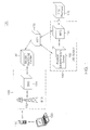
- FIG. 1 is a block diagram sketching a monitoring system 100 for monitoring location determination performance of an A-GPS method.
- the monitoring system 100 includes a mobile communication terminal 110, a test device 120, a radio base station 130, a mobile switching center 140, a STP 150, a LBS system 160 and a LBS platform 170.
- the mobile communication terminal 110 which is equipped with a GPS antenna, a GPS receiver, a GPS chip set, etc., to thereby pick up GPS radio wave broadcast from orbiting GPS satellites (not shown), extracts navigation data from the GPS radio wave and transmits the navigation data to the LBS system 160.
- the mobile communication terminal 110 can be a PDA (Personal digital Assistant), a cellular phone, a PCS (Personal Communication Service) phone, a hand-held PC, a GSM (Global System for Mobile) phone, a W-CDMA phone, an EV-DO phone, a MBS (Mobile Broadband System) phone, a WLL (Wireless Local Loop) phone and a digital TRS (Trunked Radio System) phone.
- the MBS phone refers to a mobile phone which will be used in fourth-generation communication systems.
- the test device 120 procures various parameters defined in the IS-801-1 standard in relation to the position fix from the mobile communication terminal 110 through wired and/or radio link, analyzes and processes the parameters, and displays the result of the analysis and the process.
- the radio communication refers to, but not limited to, an infra-red communication, a bluetooth communication or a RF (Radio Frequency) communication.
- the test device 120 is loaded with a built-in LBS wireless network analysis program for performing analysis on the performance of the position determination and providing display of analysis results by using the parameters defined the IS-801-1 standard.
- the LBS wireless network analysis program procures the LBS messages defined in the IS-801-1 standard which the mobile communication terminal 110 collects from a position determination server 162, performs analysis on the LBS messages and displays analysis results.
- the LBS wireless network analysis program displays information on the wireless network to which the mobile communication terminal 110 is being currently connected, a pseudo random noise code of a radio base station which gathers and transmits the LBS messages from the position determination server 162 and the strength of the pseudo random noise code.
- the mobile communication network can be a CDMA (Code Division multiple Access), GSM (Global system for Mobile communication), CDMA2000 1X, 3X, EV-DO, EV-DV, WCDMA (Wideband CDMA), PI (Portable Internet), WLL (Wireless Local Loop) and Digital TRS (Trunked Radio System).
- CDMA Code Division multiple Access
- GSM Global system for Mobile communication
- CDMA2000 1X, 3X, EV-DO, EV-DV Code Division Multiple Access
- WCDMA Wideband CDMA
- PI Portable Internet
- WLL Wireless Local Loop
- Digital TRS Trusteked Radio System
- the radio base station 130 housed with a BTS (Base station Transceiver System) 132 and a BSC (Base Station Controller) 134, performs functions such as processing call request from the mobile communication terminal 110 and relaying the parameter messages defined IS-801-1 standard communicated between the mobile communication terminal 110 and the LBS system 160.
- BTS Base station Transceiver System
- BSC Base Station Controller
- the base station transceiver system 132 is a network endpoint equipment generally performing a base band signal processing, wired/radio conversion, transmission and reception of wireless signal, and especially in the preferred embodiment, performs communication with the test device 120 via the mobile communication terminal 110.
- the base station controller 134 which performs comprehensive control over the base station transceiver system 132 performs various functions such as a radio channel allocation and release with respect to the mobile communication terminal 110, transmission power control of the test device 120 and the base station transceiver system 132, decision of soft handoff or hard handoff, transcoding and vocoding, GPS clock distribution, operation and maintenance of the base station transceiver system 132.
- the mobile switching center 140 controls the radio base station to more effectively operate and communicate with an electronic switching system installed in a public telephone network.
- the mobile switching center 140 receives data or messages from the mobile communication terminal 110 through the radio base station 130 and transfers the received data or messages to the position determination server 162.
- the signal transfer point (STP) 150 is a signal relay station for relaying and exchanging signal messages in a common channel signaling system of ITU-T.
- a signal network formed using the STP 150 operates in a non-associated mode which does not associate a speech path with a signal path.
- Various signals are transferred via the STP 150 having a speech path, other than a switching center, thereby improving reliability and cost-effectiveness.
- the STP 150 converts a signal message. When it is not possible to relay a signal message, the STP 150 notifies the signal message to another switching center.
- the LBS system 160 includes a position determination server 162 and a MPC(Mobile Positioning Center) 164.
- the position determination server 162 calculates longitude and latitude coordinate values by using the navigation data received from the mobile communication terminal 110 through the wireless network. Further, the position determination server 162 transmits an aiding data for use in the position determination of the mobile communication terminal 110 and calculates distance between the GPS satellite and the mobile communication terminal 110.
- the aiding data is transmitted according to the TCP/IP protocol.
- the mobile positioning center 164 obtains the longitude and latitude coordinate values of the mobile communication terminal 110 calculated at the position determination server 162 and transmits the coordinate values to the LBS platforms 170 that provides various location based services.
- the LBS platform 170 comprehensively refers to an application server for providing the location based services for the mobile communication terminal 110.
- the LBS platform 170 obtains the longitude and latitude coordinate values of the mobile communication terminal 110, performs coordinate conversion and the like, and finally provides the location based services.
- the data exchange between the position determination server 162 or the position center 164 and the LBS platform 170 is executed based on the TCP/IP protocol.
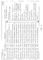
- FIG. 2 shows the LBS messages communicated between the mobile communication terminal 110 and the position determination server 162.
- a transmission time, message type and message name of the LBS message defined in the IS-801-1 standard are displayed. These messages transmitted and received between the mobile communication terminal 110 and the position determination server 162 and displayed on a real time basis on the screen of the test device 120. The user can easily rearrange the messages according to time and type of the messages and monitor rearranged messages displayed on the test device 120.
- the LBS wireless network analysis program classifies the LBS messages as forward channel messages versus reverse channel messages and distinctively displays the classified LBS messages, wherein the forward channel messages refer to LBS messages transmitted from the position determination server 162 toward the mobile communication terminal 110 whereas the reverse channel messages refer to LBS messages transmitted from the mobile communication terminal 110 toward the position determination server 162. Also the LBS wireless network analysis program classifies the LBS messages according to time of transmission or reception or according to a message type, e.g., a request type(Req_Type) and a response type(Resp_Type) to display distinctively each classified messages.
- a message type e.g., a request type(Req_Type) and a response type(Resp_Type)
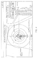
- FIG. 3 gives an exemplary two dimensional constellation of a multiple satellites about the true position of the mobile communication terminal 110.
- the position determination server 162 transmits the "Provide GPS Acquisition Assistance” message defined in the IS-801-1 standard to the mobile communication terminal 110.
- the mobile communication terminal 110 transmits the "Provide GPS Acquisition Assistance” message to the test device 120 which is connected to the mobile communication terminal 110 through wired cable link. Consequently, the LBS wireless network analysis program extracts an azimuth angle and an elevation angle for each satellite contained in the "Provide GPS Acquisition Assistance” message.
- the LBS wireless network analysis program displays at least one GPS satellite which is visible from the true position of the mobile communication terminal 110 on the two dimensional plane by using extracted azimuth angle and the elevation angle.
- the LBS wireless network analysis program indicates with a certain color the information of the GPS satellite(identification number of the GPS satellite) which the position determination server 162 provides for the mobile communication terminal 110 and extracts information on the GPS satellite that the mobile communication terminal 110 perceived from the "Provide Pseudorange Measurement" message.
- the LBS wireless network analysis program indicates the GPS satellite that the mobile communication terminal 110 perceived on the same screen but with a different color to thereby enable the user to acquire knowledge on which satellite the mobile communication terminal 110 perceives in true test environment.
- the concentric circles there are indicated an identification number of the GPS satellite(PRN number) included in the "Provide GPS Acquisition” message that the mobile communication terminal 110 receives from the position determination server 162 as well as an identification number of the GPS satellite that the mobile communication terminal 110 actually gained acquisition by using the "Provide GPS Acquisition” message.
- the concentric circles are indicated by reference to the elevation angle, the outermost circle being 0 degree, next being 30 degrees, the next being 60 degrees and the center being 90 degrees.
- the identification numbers of the GPS satellites 8, 10, 15, 17, 23, 26 and 29 are information included in the "Provide GPS Acquisition” message, whereas the identification numbers of the GPS satellites 6, 9, 18 and 24 are information that the mobile communication terminal 110 actually gained acquisition from the "Provide GPS Acquisition” message.
- the position determination performance is considered fine as the number of matching numbers between these two groups of identification numbers is large.
- the LBS wireless network analysis program renders the screen to display a C/No(Carrier to Noise) or the strength of the GPS radio wave transmitted from each GPS satellite that the mobile communication terminal 110 actually gained acquisition along with the relevant identification number of the GPS satellite.
- the C/No is a value presenting a reception sensitivity of the GPS radio wave broadcast from each GPS satellite.
- the C/No is a signal to noise ratio at 1 Hz bandwidth and is an important indicator in evaluation of capability of a GPS receiver. The larger the C/No value is the better the mobile communication terminal 110 receives GPS radio wave.
- the LBS wireless network analysis program displays the identification number of the GPs satellites and respective C/No values with a bar graph on the two dimensional coordinate along with the numeric C/No values.
- FIG. 4 is an exemplary screen displaying coordinate values of the mobile communication terminal 110 measured in accordance with the present disclosure about the concentric circles.
- the position determination server 162 transmits the "Provide Location Response "message that includes longitude and latitude values of the mobile communication terminal 110.
- the "Provide Location Response” message arrived at the mobile communication terminal 110 consequently forwarded to the test device 120 through the wired cable link, and finally the LBS wireless network analysis program extracts the longitude and the latitude values included in the "Provide Location Response” message and renders the values as a point on the map.
- the test device 120 is loaded with electronic map data.
- the electronic map data stored in the test device 120 has been made in WGS (World Geodetic System)-84 format.
- the map can also display concentric circles centering at a specific location with an interval of e. g., 50 meters as well as 4 directional intersections.
- the LBS wireless network analysis program is capable of zooming in or zooming out the map by the reference of the concentric circles or the 4 directional intersections and displaying the map zoomed in or zoomed out.
- the LBS wireless network analysis program extracts the longitude and latitude values of the mobile communication terminal 110 contained in the "Provide Location Response" message which has been received from the position determination server 162 and displays the position of the mobile communication terminal on the map.
- the LBS wireless network analysis program displays some area of the map around the coordinate values of the true position of the mobile communication terminal 110.
- the coordinate values of the true position can be determined as an average value of the measured positions(longitude and latitude values).
- At least one concentric circles having different radius each center of which is the coordinate values of the true position are displayed.
- the radius of the concentric circles may be 10 m, 20 m, 30 m, 50 m, 100 m, 150 m and the like.
- the LBS wireless network analysis program extracts the longitude and latitude values from the "Provide Location Response" message received from the mobile communication terminal 110 and displays the longitude and latitude values on the map.
- the measured position values are sequentially indicated on the map. Therefore, the measured values consecutively measured are indicated in each concentric circle as shown in FIG. 4 .
- the LBS wireless network analysis program supports both a fixed reference mode and a moving reference mode.
- the fixed reference mode refers to a map display method that the measured position is analyzed and indicated while the position of the mobile communication terminal 110 is fixed at a certain point
- the moving reference mode refers to another map display method that the measured position is analyzed and indicated while the position of the mobile communication terminal 110 is moving about on the map.
- the real time measured position of the mobile communication terminal 110 are set to be always located at the center of the map so that the map is made shifting according to the movement of the position of the mobile communication terminal 110.
- the horizontal axis(x-axis) represents a measurement sequence and the vertical axis(y-axis) represents a position error between the true position and the measured position.
- the position errors associated with the measurement sequence are indicated as dots on a real time basis and each neighboring dot is consecutively connected with a line so that the trend of the distant errors may be easily read.
- the LBS wireless network analysis program estimates and displays the number of total measurements; the number of measurements having position error whose radius is less than each of 10 m, 20 m, 30 m, 50 m, 100 m, 150 m, respectively; and/or the number of measurements having position error within up to 67% or 95% counting from the least position error among the total measured points.
- 67% of the measured points lie within the circle of radius 38.5 m and 95% of the measured points lie within the circle of radius 100.7 m, the center of each circle being the true position of the mobile communication terminal 110.
- the LBS wireless network analysis program is capable of calculating and displaying a so-called “bias east” or “bias north", wherein the bias east may be an average horizontal component of the position errors accumulated up to a certain time and the bias north may be an average vertical component of the position errors accumulated up to the certain time.
- the LBS wireless network analysis program can be stored in a computer-readable storage medium, wherein the storage medium can be any one out of a floppy disc, a hard disc, a ZIP disc, a JAZ disc, a compact disc, a DVD (Digital Versatile Disc).
- evaluation of the position determination performance can be promptly and effectively performed by using the method and system in accordance with the present disclosure.
- the wireless network operator can provide higher quality location based services to the users since the method and system provide prompt identification of the reasons for failure of the position determination when the position determination suffers.
Description
- The present disclosure relates to a method and a system for monitoring performance pertinent to a position determination of a mobile communication terminal, and more particularly to a method and system for monitoring performance pertinent to position determination of a mobile communication terminal by using various parameters defined in IS (Interim Standard) -801-1 in determining position of a mobile communication terminal in wireless/mobile communication network environment using an A-GPS scheme.
- Many companies are struggling to develop new wireless Internet technologies which can be used to provide various communication services, such as wireless Internet services, regardless of places. Wireless Internet refers to an environment or technology which allows a moving user to access the Internet through a wireless network. With the development of mobile communication technologies and the explosive increase in the use of mobile phones, the wireless Internet services have also been greatly developed.
- Among a variety of wireless Internet services provided to mobile terminals, such as cellular phones, PDAs or notebook computers, a LBS(Location Based Service) is being popularized more and more due to its wide applications and availability. The LBS can be used in various applications and conditions, such as emergency assistance, criminal tracking, GIS (Geographic Information System), difference of mobile communication fees according to locations, traffic information, vehicle navigation, logistics control and location-based CRM (Customer Relationship Management).
- In order to exploit the LBS, it is required to identify the location of a mobile communication terminal. A GPS(Global Positioning System) is generally used to track the location of a mobile communication terminal.
- The GPS is a worldwide navigation and positioning system which determines the location of an object on earth by using 24 GPS satellites orbiting the earth at an elevation of approximately 20,000 km. The GPS uses radio waves in a bandwidth of 1.5 GHz. Ground control stations which monitor the GPS satellites receive information transmitted from the satellites and synchronize transmission time. Users can monitor their locations by using GPS receivers. Generally, the GPS determines the location of an object by triangulation using four satellites. Three satellites are used for accurate triangulation, and a fourth satellite is in orbit to correct a timing error.
- To be more specific, in the GPS system, since position of 3 satellites are already known, a position fix is performed by measuring distance between the satellites and a GPS receiver. The distance between the satellites and the GPS receiver can be obtained by multiplying the light speed by a wave propagation time between the satellite and the GPS receiver, in which the wave propagation time can be obtained by calculating time difference between the transmission time at the satellite and the reception time at the GPS receiver equipped with an internal clock.
- In the meantime, the GPS has numerous advantages that, among others, it is open to anyone in the world, there is no constraint in the number of users, both a real-time position fix and a continuous tracking are possible and accuracy of position fix thereof is rather high enough for various applications.
- However, it is difficult to determine the location of an object in downtown areas surrounded by high-rise buildings due to so-called multi-path effects and the lack of visible satellites. Also, an accurate location determination can hardly be made in a tunnel, subway or in a basement of a building where satellites are not visible (where radio waves cannot reach). In addition, GPS receivers may require a TTFF (Time To First Fix) of several minutes to over ten minutes to initially determine their location, thereby causing inconvenience to the users of location-based wireless Internet services.
- A-GPS answers some of the inherent problems with GPS. The A-GPS determines the location of a mobile communication terminal by combining GPS with wireless communication network resources. A mobile communication terminal collects geolocation information from both the GPS satellites and the wireless communication network to determine its 3-dimensional location in geodetic coordinates (latitude, longitude and altitude) with high accuracy. The wireless network and the mobile communication terminal transmit and receive data or messages containing parameters defined in IS(Interim Standard)-801-1.
DocumentUS2002154058 discloses a terminal including a GPS section for receiving and a call processing section coupled to the GPS section via an interface. - Meanwhile, performance evaluation of the position determination in the position determination system for a mobile communication terminal is crucial to the communication network operator. Current performance evaluation in the A-GPS scheme, however, currently stays at the level of simply monitoring call flow messages defined in the IS-801-1 displayed on the monitor screen of a laptop computer. This bears such shortcomings that it cannot identify reasons for poor position fix performance while it only find the fact that normal position fix is suffering. In other words, the conventional position determination system cannot identify whether the poor position determination performance stems from the devices employed in the wireless communication network, from defects in the mobile communication terminal or from topography(for instance, high-rise building, mountain, trees, etc.), thereby hinders taking prompt measures thereto.
- Aspects and features of the present invention are set out in the appended claims.
- The present disclosure has been made to solve the above-mentioned problems occurring in the prior art, and an object of the present disclosure is to provide a method and system for monitoring performance pertinent to position determination of a mobile communication terminal by using various parameters defined in IS (Interim Standard) - 801-1 in determining position of a mobile communication terminal in wireless/mobile communication network environment using an A-GPS scheme.
- There is provided a system for monitoring performance of a position determination of a mobile communication terminal by using a wireless network and an A (Assisted) -GPS, the system comprising: the mobile communication terminal equipped with a GPS module for picking up GPS radio wave containing a navigation data from a GPS satellite and transmitting the navigation data to the wireless network; a test device, connected to the mobile communication terminal through wired/radio link, for being loaded with and running a LBS wireless network analysis program, wherein the LBS wireless network analysis program gathers, analyzes and processes data pertinent to the position determination and classifies processed data by at least one classification reference and displays classified data in the format of text or graph; and a position determination server for receiving the navigation data from the wireless network, converting the navigation data into longitude and latitude coordinate values, transmitting the longitude and latitude coordinate values to the mobile communication terminal and performs transmission and reception of the data pertinent to the position determination.
- In accordance with another example, there is provided a method for monitoring performance of position determination of a mobile communication terminal in a communication system including a mobile communication terminal by using a wireless network and an Assisted-GPS, the method comprising
at the mobile communication terminal, picking up GPS radio wave containing a navigation data from a GPS satellite and transmitting the navigation data to the wireless network;
loading and running a LBS wireless network analysis program at a test device connected to the mobile communication network through wired/radio link;
at a position determination server, receiving the navigation data from the wireless network, converting the navigation data into longitude and latitude coordinate values, transmitting the longitude and latitude coordinate values to the mobile communication terminal and exchanging data pertinent to the position determination with the mobile communication terminal, wherein the data pertinent to the position determination includes a first information on the GPS satellite which the position determination server is arranged to transmit to the mobile communication terminal for aiding position determination of the mobile communication terminal and a second information on the GPS satellite which the mobile communication terminal is arranged to perceive actually,
wherein running the LBS wireless network analysis program at the test device comprises receiving the data pertinent to the position determination from the mobile communication terminal, extracting the first information on the GPS satellite and the second information on GPS satellite, and analyzing and displaying the first information on the GPS satellite and the second information on GPS satellite. - The above and other features and advantages will be more apparent from the following detailed description taken in conjunction with the accompanying drawings, in which:
-
FIG. 1 is a block diagram sketching amonitoring system 100 for monitoring location determination performance of an A-GPS method; -
FIG. 2 shows the LBS messages communicated between themobile communication terminal 110 and theposition determination server 162; -
FIG. 3 gives an exemplary two dimensional constellation of multiple satellites about the true position of themobile communication terminal 110; and -
FIG. 4 is an exemplary screen displaying coordinate values of themobile communication terminal 110 measured in accordance with the present disclosure about the concentric circles. - Hereinafter, a preferred example will be described with reference to the accompanying drawings. In the drawings, the same element, although depicted in different drawings, will be designated by the same reference numeral or character. Also, in the following description, a detailed description of known functions and configurations incorporated herein will be omitted when it may make the subject matter unclear.
-
FIG. 1 is a block diagram sketching amonitoring system 100 for monitoring location determination performance of an A-GPS method. - The
monitoring system 100 includes amobile communication terminal 110, atest device 120, aradio base station 130, amobile switching center 140, aSTP 150, a LBS system 160 and aLBS platform 170. - The
mobile communication terminal 110 which is equipped with a GPS antenna, a GPS receiver, a GPS chip set, etc., to thereby pick up GPS radio wave broadcast from orbiting GPS satellites (not shown), extracts navigation data from the GPS radio wave and transmits the navigation data to the LBS system 160. - The
mobile communication terminal 110 can be a PDA (Personal digital Assistant), a cellular phone, a PCS (Personal Communication Service) phone, a hand-held PC, a GSM (Global System for Mobile) phone, a W-CDMA phone, an EV-DO phone, a MBS (Mobile Broadband System) phone, a WLL (Wireless Local Loop) phone and a digital TRS (Trunked Radio System) phone. Herein, the MBS phone refers to a mobile phone which will be used in fourth-generation communication systems. - The
test device 120 procures various parameters defined in the IS-801-1 standard in relation to the position fix from themobile communication terminal 110 through wired and/or radio link, analyzes and processes the parameters, and displays the result of the analysis and the process. Herein, the radio communication refers to, but not limited to, an infra-red communication, a bluetooth communication or a RF (Radio Frequency) communication. Thetest device 120 is loaded with a built-in LBS wireless network analysis program for performing analysis on the performance of the position determination and providing display of analysis results by using the parameters defined the IS-801-1 standard. - The LBS wireless network analysis program procures the LBS messages defined in the IS-801-1 standard which the
mobile communication terminal 110 collects from aposition determination server 162, performs analysis on the LBS messages and displays analysis results. In addition, the LBS wireless network analysis program displays information on the wireless network to which themobile communication terminal 110 is being currently connected, a pseudo random noise code of a radio base station which gathers and transmits the LBS messages from theposition determination server 162 and the strength of the pseudo random noise code. - The mobile communication network can be a CDMA (Code Division multiple Access), GSM (Global system for Mobile communication), CDMA2000 1X, 3X, EV-DO, EV-DV, WCDMA (Wideband CDMA), PI (Portable Internet), WLL (Wireless Local Loop) and Digital TRS (Trunked Radio System).
- The
radio base station 130, housed with a BTS (Base station Transceiver System) 132 and a BSC (Base Station Controller) 134, performs functions such as processing call request from themobile communication terminal 110 and relaying the parameter messages defined IS-801-1 standard communicated between themobile communication terminal 110 and the LBS system 160. - The base station transceiver system 132 is a network endpoint equipment generally performing a base band signal processing, wired/radio conversion, transmission and reception of wireless signal, and especially in the preferred embodiment, performs communication with the
test device 120 via themobile communication terminal 110. - The
base station controller 134 which performs comprehensive control over the base station transceiver system 132 performs various functions such as a radio channel allocation and release with respect to themobile communication terminal 110, transmission power control of thetest device 120 and the base station transceiver system 132, decision of soft handoff or hard handoff, transcoding and vocoding, GPS clock distribution, operation and maintenance of the base station transceiver system 132. - The
mobile switching center 140 controls the radio base station to more effectively operate and communicate with an electronic switching system installed in a public telephone network. Themobile switching center 140 receives data or messages from themobile communication terminal 110 through theradio base station 130 and transfers the received data or messages to theposition determination server 162. - The signal transfer point (STP) 150 is a signal relay station for relaying and exchanging signal messages in a common channel signaling system of ITU-T. A signal network formed using the
STP 150 operates in a non-associated mode which does not associate a speech path with a signal path. Various signals are transferred via theSTP 150 having a speech path, other than a switching center, thereby improving reliability and cost-effectiveness. Also, theSTP 150 converts a signal message. When it is not possible to relay a signal message, theSTP 150 notifies the signal message to another switching center. - The LBS system 160 includes a
position determination server 162 and a MPC(Mobile Positioning Center) 164. Theposition determination server 162 calculates longitude and latitude coordinate values by using the navigation data received from themobile communication terminal 110 through the wireless network. Further, theposition determination server 162 transmits an aiding data for use in the position determination of themobile communication terminal 110 and calculates distance between the GPS satellite and themobile communication terminal 110. Herein, the aiding data is transmitted according to the TCP/IP protocol. - The
mobile positioning center 164 obtains the longitude and latitude coordinate values of themobile communication terminal 110 calculated at theposition determination server 162 and transmits the coordinate values to theLBS platforms 170 that provides various location based services. - The
LBS platform 170 comprehensively refers to an application server for providing the location based services for themobile communication terminal 110. TheLBS platform 170 obtains the longitude and latitude coordinate values of themobile communication terminal 110, performs coordinate conversion and the like, and finally provides the location based services. The data exchange between theposition determination server 162 or theposition center 164 and theLBS platform 170 is executed based on the TCP/IP protocol. -
FIG. 2 shows the LBS messages communicated between themobile communication terminal 110 and theposition determination server 162. - Referring to the exemplary screen of
FIG. 2 , a transmission time, message type and message name of the LBS message defined in the IS-801-1 standard are displayed. These messages transmitted and received between themobile communication terminal 110 and theposition determination server 162 and displayed on a real time basis on the screen of thetest device 120. The user can easily rearrange the messages according to time and type of the messages and monitor rearranged messages displayed on thetest device 120. - Kinds of messages analyzed and displayed by the LBS wireless network analysis program, as shown in
FIG. 2 , "Request MS Information", "Request Pilot Phase Measurement", "Provide MS Information", "Provide Pilot Phase Measurement", "Request Pseudorange Measurement", "Provide Pseudorange Measurement", "Provide GPS Acquisition Assistance", "Provide GPS Sensitivity Assistance", "Request Location response", etc. - The LBS wireless network analysis program classifies the LBS messages as forward channel messages versus reverse channel messages and distinctively displays the classified LBS messages, wherein the forward channel messages refer to LBS messages transmitted from the
position determination server 162 toward themobile communication terminal 110 whereas the reverse channel messages refer to LBS messages transmitted from themobile communication terminal 110 toward theposition determination server 162. Also the LBS wireless network analysis program classifies the LBS messages according to time of transmission or reception or according to a message type, e.g., a request type(Req_Type) and a response type(Resp_Type) to display distinctively each classified messages. - Turning back to
FIG. 2 , detailed information on the "Provide MS Information" message which is highlighted on the third row of the left hand side of the screen is being displayed on the right hand side of the screen. On the right hand side of the screen, information on auxiliary data for use in the mobile communication terminal's reception of the GPS radio wave such as a GPS Acquisition Assistance, GPS Sensitivity Assistance, GPS Almanac, GPS Ephemeris, GPS Navigation Message Bits, GPS Almanac Correction and GPS Autonomous Acquisition Capable are being displayed. - Herein, the message "Provide MS Information" is well known from the IS-801-1 standard as such will not be discussed in great detail.
-
FIG. 3 gives an exemplary two dimensional constellation of a multiple satellites about the true position of themobile communication terminal 110. - Description will now be given in conjunction with
FIG. 1 andFIG. 3 . Theposition determination server 162 transmits the "Provide GPS Acquisition Assistance" message defined in the IS-801-1 standard to themobile communication terminal 110. Themobile communication terminal 110 transmits the "Provide GPS Acquisition Assistance" message to thetest device 120 which is connected to themobile communication terminal 110 through wired cable link. Consequently, the LBS wireless network analysis program extracts an azimuth angle and an elevation angle for each satellite contained in the "Provide GPS Acquisition Assistance" message. The LBS wireless network analysis program displays at least one GPS satellite which is visible from the true position of themobile communication terminal 110 on the two dimensional plane by using extracted azimuth angle and the elevation angle. - Meanwhile, the LBS wireless network analysis program indicates with a certain color the information of the GPS satellite(identification number of the GPS satellite) which the
position determination server 162 provides for themobile communication terminal 110 and extracts information on the GPS satellite that themobile communication terminal 110 perceived from the "Provide Pseudorange Measurement" message. Next, the LBS wireless network analysis program indicates the GPS satellite that themobile communication terminal 110 perceived on the same screen but with a different color to thereby enable the user to acquire knowledge on which satellite themobile communication terminal 110 perceives in true test environment. - Turning back to
FIG. 3 , around the concentric circles, there are indicated an identification number of the GPS satellite(PRN number) included in the "Provide GPS Acquisition" message that themobile communication terminal 110 receives from theposition determination server 162 as well as an identification number of the GPS satellite that themobile communication terminal 110 actually gained acquisition by using the "Provide GPS Acquisition" message. Herein, the concentric circles are indicated by reference to the elevation angle, the outermost circle being 0 degree, next being 30 degrees, the next being 60 degrees and the center being 90 degrees. - In the concentric circles of
FIG. 3 , the identification numbers of theGPS satellites GPS satellites mobile communication terminal 110 actually gained acquisition from the "Provide GPS Acquisition" message. The position determination performance is considered fine as the number of matching numbers between these two groups of identification numbers is large. - The LBS wireless network analysis program renders the screen to display a C/No(Carrier to Noise) or the strength of the GPS radio wave transmitted from each GPS satellite that the
mobile communication terminal 110 actually gained acquisition along with the relevant identification number of the GPS satellite. Herein the C/No is a value presenting a reception sensitivity of the GPS radio wave broadcast from each GPS satellite. In other words, the C/No is a signal to noise ratio at 1 Hz bandwidth and is an important indicator in evaluation of capability of a GPS receiver. The larger the C/No value is the better themobile communication terminal 110 receives GPS radio wave. The LBS wireless network analysis program, as shown in lower part ofFIG. 3 , displays the identification number of the GPs satellites and respective C/No values with a bar graph on the two dimensional coordinate along with the numeric C/No values. -
FIG. 4 is an exemplary screen displaying coordinate values of themobile communication terminal 110 measured in accordance with the present disclosure about the concentric circles. - Describing in conjunction with
FIG. 1 andFIG. 4 , theposition determination server 162 transmits the "Provide Location Response "message that includes longitude and latitude values of themobile communication terminal 110. The "Provide Location Response" message arrived at themobile communication terminal 110 consequently forwarded to thetest device 120 through the wired cable link, and finally the LBS wireless network analysis program extracts the longitude and the latitude values included in the "Provide Location Response" message and renders the values as a point on the map. To display the map on the screen, thetest device 120 is loaded with electronic map data. - Herein, the electronic map data stored in the
test device 120 has been made in WGS (World Geodetic System)-84 format. The map can also display concentric circles centering at a specific location with an interval of e. g., 50 meters as well as 4 directional intersections. In addition, the LBS wireless network analysis program is capable of zooming in or zooming out the map by the reference of the concentric circles or the 4 directional intersections and displaying the map zoomed in or zoomed out. - The LBS wireless network analysis program extracts the longitude and latitude values of the
mobile communication terminal 110 contained in the "Provide Location Response" message which has been received from theposition determination server 162 and displays the position of the mobile communication terminal on the map. - To be more specific, the LBS wireless network analysis program displays some area of the map around the coordinate values of the true position of the
mobile communication terminal 110. Herein, the coordinate values of the true position can be determined as an average value of the measured positions(longitude and latitude values). At least one concentric circles having different radius each center of which is the coordinate values of the true position are displayed. For instance, the radius of the concentric circles may be 10 m, 20 m, 30 m, 50 m, 100 m, 150 m and the like. - Next, the LBS wireless network analysis program extracts the longitude and latitude values from the "Provide Location Response" message received from the
mobile communication terminal 110 and displays the longitude and latitude values on the map. In case the positions of themobile communication terminal 110 are consecutively determined, the measured position values are sequentially indicated on the map. Therefore, the measured values consecutively measured are indicated in each concentric circle as shown inFIG. 4 . - In the meantime, the LBS wireless network analysis program supports both a fixed reference mode and a moving reference mode. The fixed reference mode refers to a map display method that the measured position is analyzed and indicated while the position of the
mobile communication terminal 110 is fixed at a certain point, while the moving reference mode refers to another map display method that the measured position is analyzed and indicated while the position of themobile communication terminal 110 is moving about on the map. In case of the moving reference mode, the real time measured position of themobile communication terminal 110 are set to be always located at the center of the map so that the map is made shifting according to the movement of the position of themobile communication terminal 110. - The horizontal axis(x-axis) represents a measurement sequence and the vertical axis(y-axis) represents a position error between the true position and the measured position. The position errors associated with the measurement sequence are indicated as dots on a real time basis and each neighboring dot is consecutively connected with a line so that the trend of the distant errors may be easily read.
- The LBS wireless network analysis program estimates and displays the number of total measurements; the number of measurements having position error whose radius is less than each of 10 m, 20 m, 30 m, 50 m, 100 m, 150 m, respectively; and/or the number of measurements having position error within up to 67% or 95% counting from the least position error among the total measured points. Referring to
FIG. 4 , it can be known that 67% of the measured points lie within the circle of radius 38.5 m and 95% of the measured points lie within the circle of radius 100.7 m, the center of each circle being the true position of themobile communication terminal 110. - Certainly, the scale or range of the position errors can vary. In addition to the above, the LBS wireless network analysis program is capable of calculating and displaying a so-called "bias east" or "bias north", wherein the bias east may be an average horizontal component of the position errors accumulated up to a certain time and the bias north may be an average vertical component of the position errors accumulated up to the certain time.
- Meanwhile, the LBS wireless network analysis program can be stored in a computer-readable storage medium, wherein the storage medium can be any one out of a floppy disc, a hard disc, a ZIP disc, a JAZ disc, a compact disc, a DVD (Digital Versatile Disc).
- As described above, evaluation of the position determination performance can be promptly and effectively performed by using the method and system in accordance with the present disclosure.
- In addition, the wireless network operator can provide higher quality location based services to the users since the method and system provide prompt identification of the reasons for failure of the position determination when the position determination suffers.
Claims (8)
- A system for monitoring performance of a position determination of a mobile communication terminal (110) by using a wireless network and an Assisted-GPS, the system comprising:the mobile communication terminal (110) equipped with a GPS module for picking up GPS radio wave containing a navigation data from a GPS satellite and transmitting the navigation data to the wireless network;a test device (120), connected to the mobile communication terminal (110) through wired/radio link, for being loaded with and running a LBS wireless network analysis program; anda position determination server (162) for receiving the navigation data from the wireless network, converting the navigation data into longitude and latitude coordinate values, transmitting the longitude and latitude coordinate values to the mobile communication terminal (110) and exchanging data pertinent to the position determination with the mobile communication terminal (110), wherein the data pertinent to the position determination includes a first information on the GPS satellite which the position determination server (162) is arranged to transmit to the mobile communication terminal (110) for aiding position determination of the mobile communication terminal (110) and a second information on the GPS satellite which the mobile communication terminal (110) is arranged to perceive actually,wherein the LBS wireless network analysis program in the test device (120) is arranged to receive the data pertinent to the position determination from the mobile communication terminal (110), extract the first information on the GPS satellite and the second information on GPS satellite, and analyze and display the first information on the GPS satellite and the second information on GPS satellite.
- The system of claim 1, wherein the data pertinent to the position determination is a LBS message that the mobile communication terminal acquires from the position determination server, the LBS message being defined in the IS-801-1 standard, and the LBS wireless network communication network analyzes the LBS message and consequently indicates the time information of transmission or reception of the LBS message, the name of the LBS message, and a type of message, wherein the type of message is whether the LBS message is a forward channel message, a reverse channel message, a request message or a response message.
- The system of claim 1 or 2, wherein the LBS wireless network analysis program analyzes and displays information on the GPS satellite, wherein the information on the GPS satellite is more than one out of an azimuth angle, an elevation angle, a total number of the GPS satellites and an identification number of each satellite included in a "Provide GPS Acquisition" message, or a "Provide Pseudorange Measurement" message.
- The system of claim 2, wherein the LBS wireless communication analysis program extracts and displays information on the wireless network, a pseudo random noise code of a radio base station which transmits the LBS message and strength of the pseudo random noise code, from the LBS message.
- A method for monitoring performance of position determination of a mobile communication terminal in a communication system including a mobile communication terminal by using a wireless network and an Assisted-GPS, the method comprising
at the mobile communication terminal, picking up GPS radio wave containing a navigation data from a GPS satellite and transmitting the navigation data to the wireless network;
loading and running a LBS wireless network analysis program at a test device connected to the mobile communication network through wired/radio link;
at a position determination server, receiving the navigation data from the wireless network, converting the navigation data into longitude and latitude coordinate values, transmitting the longitude and latitude coordinate values to the mobile communication terminal and exchanging data pertinent to the position determination with the mobile communication terminal, wherein the data pertinent to the position determination includes a first information on the GPS satellite which the position determination server is arranged to transmit to the mobile communication terminal for aiding position determination of the mobile communication terminal and a second information on the GPS satellite which the mobile communication terminal is arranged to perceive actually,
wherein running the LBS wireless network analysis program at the test device comprises receiving the data pertinent to the position determination from the mobile communication terminal, extracting the first information on the GPS satellite and the second information on GPS satellite, and analyzing and displaying the first information on the GPS satellite and the second information on GPS satellite. - The method of claim 5, wherein the data pertinent to the position determination is a LBS message that the mobile communication terminal acquires from the position determination server, the LBS message being defined in the IS-801-1 standard, and the LBS wireless network communication network analyzes the LBS message and consequently indicates the time information of transmission or reception of the LBS message, the name of the LBS message, and a type of message, wherein the type of message is whether the LBS message is a forward channel message, a reverse channel message, a request message or a response message.
- The method of claim 5 or 6, wherein the LBS wireless network analysis program analyzes and displays information on the GPS satellite, wherein the information on the GPS satellite is more than one out of an azimuth angle, an elevation angle, a total number of the GPS satellites and an identification number of each satellite included in a "Provide GPS Acquisition" message, or a "Provide Pseudorange Measurement" message.
- The method of claim 6, wherein the LBS wireless communication analysis program extracts and displays information on the wireless network, a pseudo random noise code of a radio base station which transmits the LBS message and strength of the pseudo random noise code, from the LBS message.
Applications Claiming Priority (5)
| Application Number | Priority Date | Filing Date | Title |
|---|---|---|---|
| KR20030007036 | 2003-02-04 | ||
| KR2003007036 | 2003-02-04 | ||
| KR2004006781 | 2004-02-02 | ||
| KR1020040006781A KR100441048B1 (en) | 2003-02-04 | 2004-02-02 | Method and System for Accessing Mobile Communication Terminal Position Determination Performance of Mobile Terminal by Using Wireless Communication Network and A-GPS |
| PCT/KR2004/000198 WO2004070513A2 (en) | 2003-02-04 | 2004-02-04 | Method and system for monitoring mobile communication terminal position determination performance by using wireless communication network and a-gps |
Publications (3)
| Publication Number | Publication Date |
|---|---|
| EP1597841A2 EP1597841A2 (en) | 2005-11-23 |
| EP1597841A4 EP1597841A4 (en) | 2010-04-07 |
| EP1597841B1 true EP1597841B1 (en) | 2014-10-01 |
Family
ID=32852792
Family Applications (1)
| Application Number | Title | Priority Date | Filing Date |
|---|---|---|---|
| EP04708079.1A Expired - Lifetime EP1597841B1 (en) | 2003-02-04 | 2004-02-04 | Method and system for monitoring mobile communication terminal position determination performance by using wireless communication network and a-gps |
Country Status (4)
| Country | Link |
|---|---|
| US (1) | US20060258365A1 (en) |
| EP (1) | EP1597841B1 (en) |
| JP (1) | JP2006524443A (en) |
| WO (1) | WO2004070513A2 (en) |
Families Citing this family (32)
| Publication number | Priority date | Publication date | Assignee | Title |
|---|---|---|---|---|
| KR20050101505A (en) * | 2004-04-19 | 2005-10-24 | 삼성전자주식회사 | Method and device for monitering of multi sessions in wireless communication systems |
| KR100617787B1 (en) * | 2004-06-29 | 2006-08-28 | 삼성전자주식회사 | Gps receiver for detecting jammer using fast fourier transform and therefor method |
| US7747258B2 (en) | 2005-02-04 | 2010-06-29 | Qualcomm Incorporated | Method and apparatus for performing position determination with pre-session action |
| CN100454850C (en) * | 2005-09-27 | 2009-01-21 | 华为技术有限公司 | System and method for carrying out monitoring on mobile IP user |
| KR100754662B1 (en) | 2005-10-06 | 2007-09-03 | 삼성전자주식회사 | Method of acquiring initial gps signal in broadcasting system and system using the metho |
| EP1938488B1 (en) | 2005-10-21 | 2015-09-09 | T-Mobile, USA, Inc | System and method for determining device location in an ip-based wireless telecommunications network |
| US20070184851A1 (en) * | 2005-12-30 | 2007-08-09 | Pango Networks, Inc. | Methods and apparatus for location synthesis in a wireless network environment |
| US9008682B2 (en) | 2006-02-10 | 2015-04-14 | Telefonaktiebolaget L M Ericsson (Publ) | Performance monitoring of location-based service in a mobile telecommunications network |
| CA2619648C (en) | 2006-04-13 | 2013-12-31 | T-Mobile Usa, Inc. | Mobile computing device geographic location determination |
| WO2008049132A2 (en) | 2006-10-20 | 2008-04-24 | T-Mobile Usa, Inc. | System and method for determining a subscriber's zone information |
| US8953567B2 (en) | 2006-10-20 | 2015-02-10 | T—Mobile USA, Inc. | System and method for utilizing IP-based wireless telecommunications client location data |
| WO2008049131A2 (en) * | 2006-10-20 | 2008-04-24 | T-Mobile Usa, Inc. | Two stage mobile device geographic location determination |
| TW200842591A (en) * | 2007-04-20 | 2008-11-01 | Genesys Logic Inc | OTG device for multi-directional transmitting GPS data and controlling method of same |
| US20090005970A1 (en) * | 2007-06-27 | 2009-01-01 | Raytheon Company | System and Method for Displaying Geographical Information |
| US7889888B2 (en) * | 2007-06-27 | 2011-02-15 | Raytheon Company | System and method for grouping and visualizing data |
| US20090006323A1 (en) * | 2007-06-27 | 2009-01-01 | Raytheon Company | System and Method for Analyzing Intelligence Information |
| KR100963544B1 (en) * | 2008-03-17 | 2010-06-15 | 에스케이 텔레콤주식회사 | Method And Smart Card for Providing Location Based Service |
| US7970414B1 (en) | 2008-04-24 | 2011-06-28 | Cellco Partnership | System and method for providing assisted GPS location service to dual mode mobile station |
| US8718592B2 (en) | 2009-05-15 | 2014-05-06 | T-Mobile Usa, Inc. | Mobile device location determination using micronetworks |
| US8311557B2 (en) * | 2009-05-15 | 2012-11-13 | T-Mobile Usa, Inc. | Facility for selecting a mobile device location determination technique |
| US9094927B2 (en) | 2010-04-28 | 2015-07-28 | T-Mobile Usa, Inc. | Location continuity service for locating mobile devices using multiple access networks including wireless telecommunication networks |
| US8472974B2 (en) | 2010-04-28 | 2013-06-25 | T-Mobile Usa, Inc. | Location continuity service for locating mobile devices using multiple access networks including wireless telecommunication networks |
| US8966555B2 (en) | 2010-09-15 | 2015-02-24 | At&T Intellectual Property I, L.P. | Method and system for performance monitoring of network terminal devices |
| KR101822183B1 (en) | 2011-02-09 | 2018-01-26 | 삼성전자주식회사 | Apparatus and method for integrated positioning |
| US8897807B2 (en) * | 2011-11-15 | 2014-11-25 | Cellco Partnership | Using mobile messaging service message(s) as bearer for location related communications during voice call |
| CN102724632B (en) * | 2012-06-29 | 2014-11-12 | 武汉钢铁(集团)公司 | Method for acquiring geographical location data |
| KR102034082B1 (en) | 2015-05-13 | 2019-10-18 | 한국전자통신연구원 | Positioning environment analysis apparatus, positioning performance projection method and system of terminal using the same |
| US20170357411A1 (en) | 2016-06-11 | 2017-12-14 | Apple Inc. | User interface for initiating a telephone call |
| US11765114B2 (en) | 2017-05-16 | 2023-09-19 | Apple Inc. | Voice communication method |
| CN112649822A (en) * | 2020-09-16 | 2021-04-13 | 桂林电子科技大学 | Navigation positioning method based on electronic information |
| CN113347566B (en) * | 2021-05-31 | 2023-05-23 | 国能朔黄铁路发展有限责任公司 | Locomotive communication equipment monitoring method, device and system |
| US20230063173A1 (en) * | 2021-08-31 | 2023-03-02 | Apple Inc. | Methods and interfaces for initiating communications |
Family Cites Families (8)
| Publication number | Priority date | Publication date | Assignee | Title |
|---|---|---|---|---|
| US6453237B1 (en) * | 1999-04-23 | 2002-09-17 | Global Locate, Inc. | Method and apparatus for locating and providing services to mobile devices |
| US6703971B2 (en) * | 2001-02-21 | 2004-03-09 | Sirf Technologies, Inc. | Mode determination for mobile GPS terminals |
| DE10110136B4 (en) * | 2001-03-08 | 2013-01-24 | Harman Becker Automotive Systems Gmbh | Method and arrangement for testing GPS receivers |
| US6773311B2 (en) * | 2002-02-06 | 2004-08-10 | Fci Americas Technology, Inc. | Electrical splice connector |
| JP2003255039A (en) * | 2002-02-28 | 2003-09-10 | Japan Radio Co Ltd | Method and apparatus for testing network assist-type gps receiver |
| JP2004056604A (en) * | 2002-07-23 | 2004-02-19 | Fujitsu Ltd | Network operation supervisory device |
| US6911918B2 (en) * | 2002-12-19 | 2005-06-28 | Shawfu Chen | Traffic flow and route selection display system for routing vehicles |
| US20040193373A1 (en) * | 2003-03-25 | 2004-09-30 | The Boeing Company | Autonomous navigation error correction |
-
2004
- 2004-02-04 US US10/544,890 patent/US20060258365A1/en not_active Abandoned
- 2004-02-04 WO PCT/KR2004/000198 patent/WO2004070513A2/en active Application Filing
- 2004-02-04 EP EP04708079.1A patent/EP1597841B1/en not_active Expired - Lifetime
- 2004-02-04 JP JP2005518447A patent/JP2006524443A/en active Pending
Also Published As
| Publication number | Publication date |
|---|---|
| EP1597841A4 (en) | 2010-04-07 |
| WO2004070513A3 (en) | 2004-11-18 |
| EP1597841A2 (en) | 2005-11-23 |
| US20060258365A1 (en) | 2006-11-16 |
| JP2006524443A (en) | 2006-10-26 |
| WO2004070513A2 (en) | 2004-08-19 |
Similar Documents
| Publication | Publication Date | Title |
|---|---|---|
| EP1597841B1 (en) | Method and system for monitoring mobile communication terminal position determination performance by using wireless communication network and a-gps | |
| EP2144079B1 (en) | Method and system for using altitude information in a satellite positioning system | |
| CN1898975B (en) | TDOA/GPS hybrid wireless location system | |
| US8103289B2 (en) | System of utilizing cell information to locate a wireless device | |
| EP1986017B1 (en) | Method and apparatus for improving radio location accuracy with measurements | |
| KR100553305B1 (en) | Method and system for validating a mobile station location fix | |
| US6570529B2 (en) | Autonomous calibration of a wireless-global positioning system | |
| EP1450179B1 (en) | Test apparatus and control method for a wireless communication network | |
| KR100581290B1 (en) | Base station and mobile terminal for location detecting, its method for location detecting | |
| US7262731B2 (en) | Method and system for optimizing location-based service by adjusting maximum antenna range | |
| US20160003949A1 (en) | Systems and methods for estimating whether a receiver is inside or outside a building | |
| EP1903349A1 (en) | Mobile communication terminal for receiving position information service and method thereof | |
| Sahoo et al. | Integrating GPS, GSM and cellular phone for location tracking and monitoring | |
| CN112904390B (en) | Positioning method, positioning device, computer equipment and storage medium | |
| KR100441048B1 (en) | Method and System for Accessing Mobile Communication Terminal Position Determination Performance of Mobile Terminal by Using Wireless Communication Network and A-GPS | |
| Resch et al. | Global positioning in harsh environments | |
| Kim et al. | Performance analysis of position location methods based on IS-801 Standard | |
| Chen | Integration of satellite and cellular positioning technologies | |
| KR20050098511A (en) | Apparatus and method for displaying receiving signal sensitivity of global positioning system |
Legal Events
| Date | Code | Title | Description |
|---|---|---|---|
| PUAI | Public reference made under article 153(3) epc to a published international application that has entered the european phase |
Free format text: ORIGINAL CODE: 0009012 |
|
| 17P | Request for examination filed |
Effective date: 20050902 |
|
| AK | Designated contracting states |
Kind code of ref document: A2 Designated state(s): AT BE BG CH CY CZ DE DK EE ES FI FR GB GR HU IE IT LI LU MC NL PT RO SE SI SK TR |
|
| AX | Request for extension of the european patent |
Extension state: AL LT LV MK |
|
| DAX | Request for extension of the european patent (deleted) | ||
| A4 | Supplementary search report drawn up and despatched |
Effective date: 20100308 |
|
| 17Q | First examination report despatched |
Effective date: 20110727 |
|
| REG | Reference to a national code |
Ref country code: DE Ref legal event code: R079 Ref document number: 602004045899 Country of ref document: DE Free format text: PREVIOUS MAIN CLASS: H04B0007260000 Ipc: G01S0005020000 |
|
| RIC1 | Information provided on ipc code assigned before grant |
Ipc: H04W 64/00 20090101ALI20140228BHEP Ipc: G01S 5/02 20100101AFI20140228BHEP |
|
| GRAP | Despatch of communication of intention to grant a patent |
Free format text: ORIGINAL CODE: EPIDOSNIGR1 |
|
| INTG | Intention to grant announced |
Effective date: 20140428 |
|
| GRAS | Grant fee paid |
Free format text: ORIGINAL CODE: EPIDOSNIGR3 |
|
| GRAA | (expected) grant |
Free format text: ORIGINAL CODE: 0009210 |
|
| AK | Designated contracting states |
Kind code of ref document: B1 Designated state(s): AT BE BG CH CY CZ DE DK EE ES FI FR GB GR HU IE IT LI LU MC NL PT RO SE SI SK TR |
|
| REG | Reference to a national code |
Ref country code: GB Ref legal event code: FG4D |
|
| REG | Reference to a national code |
Ref country code: CH Ref legal event code: EP Ref country code: AT Ref legal event code: REF Ref document number: 689785 Country of ref document: AT Kind code of ref document: T Effective date: 20141015 |
|
| REG | Reference to a national code |
Ref country code: IE Ref legal event code: FG4D |
|
| REG | Reference to a national code |
Ref country code: DE Ref legal event code: R096 Ref document number: 602004045899 Country of ref document: DE Effective date: 20141113 |
|
| REG | Reference to a national code |
Ref country code: NL Ref legal event code: VDEP Effective date: 20141001 |
|
| REG | Reference to a national code |
Ref country code: AT Ref legal event code: MK05 Ref document number: 689785 Country of ref document: AT Kind code of ref document: T Effective date: 20141001 |
|
| PG25 | Lapsed in a contracting state [announced via postgrant information from national office to epo] |
Ref country code: NL Free format text: LAPSE BECAUSE OF FAILURE TO SUBMIT A TRANSLATION OF THE DESCRIPTION OR TO PAY THE FEE WITHIN THE PRESCRIBED TIME-LIMIT Effective date: 20141001 |
|
| PG25 | Lapsed in a contracting state [announced via postgrant information from national office to epo] |
Ref country code: ES Free format text: LAPSE BECAUSE OF FAILURE TO SUBMIT A TRANSLATION OF THE DESCRIPTION OR TO PAY THE FEE WITHIN THE PRESCRIBED TIME-LIMIT Effective date: 20141001 Ref country code: PT Free format text: LAPSE BECAUSE OF FAILURE TO SUBMIT A TRANSLATION OF THE DESCRIPTION OR TO PAY THE FEE WITHIN THE PRESCRIBED TIME-LIMIT Effective date: 20150202 Ref country code: FI Free format text: LAPSE BECAUSE OF FAILURE TO SUBMIT A TRANSLATION OF THE DESCRIPTION OR TO PAY THE FEE WITHIN THE PRESCRIBED TIME-LIMIT Effective date: 20141001 Ref country code: CZ Free format text: LAPSE BECAUSE OF FAILURE TO SUBMIT A TRANSLATION OF THE DESCRIPTION OR TO PAY THE FEE WITHIN THE PRESCRIBED TIME-LIMIT Effective date: 20141001 |
|
| PG25 | Lapsed in a contracting state [announced via postgrant information from national office to epo] |
Ref country code: GR Free format text: LAPSE BECAUSE OF FAILURE TO SUBMIT A TRANSLATION OF THE DESCRIPTION OR TO PAY THE FEE WITHIN THE PRESCRIBED TIME-LIMIT Effective date: 20150102 Ref country code: CY Free format text: LAPSE BECAUSE OF FAILURE TO SUBMIT A TRANSLATION OF THE DESCRIPTION OR TO PAY THE FEE WITHIN THE PRESCRIBED TIME-LIMIT Effective date: 20141001 Ref country code: AT Free format text: LAPSE BECAUSE OF FAILURE TO SUBMIT A TRANSLATION OF THE DESCRIPTION OR TO PAY THE FEE WITHIN THE PRESCRIBED TIME-LIMIT Effective date: 20141001 Ref country code: SE Free format text: LAPSE BECAUSE OF FAILURE TO SUBMIT A TRANSLATION OF THE DESCRIPTION OR TO PAY THE FEE WITHIN THE PRESCRIBED TIME-LIMIT Effective date: 20141001 |
|
| PG25 | Lapsed in a contracting state [announced via postgrant information from national office to epo] |
Ref country code: BE Free format text: LAPSE BECAUSE OF NON-PAYMENT OF DUE FEES Effective date: 20150228 |
|
| REG | Reference to a national code |
Ref country code: DE Ref legal event code: R097 Ref document number: 602004045899 Country of ref document: DE |
|
| PG25 | Lapsed in a contracting state [announced via postgrant information from national office to epo] |
Ref country code: SK Free format text: LAPSE BECAUSE OF FAILURE TO SUBMIT A TRANSLATION OF THE DESCRIPTION OR TO PAY THE FEE WITHIN THE PRESCRIBED TIME-LIMIT Effective date: 20141001 Ref country code: RO Free format text: LAPSE BECAUSE OF FAILURE TO SUBMIT A TRANSLATION OF THE DESCRIPTION OR TO PAY THE FEE WITHIN THE PRESCRIBED TIME-LIMIT Effective date: 20141001 Ref country code: EE Free format text: LAPSE BECAUSE OF FAILURE TO SUBMIT A TRANSLATION OF THE DESCRIPTION OR TO PAY THE FEE WITHIN THE PRESCRIBED TIME-LIMIT Effective date: 20141001 Ref country code: DK Free format text: LAPSE BECAUSE OF FAILURE TO SUBMIT A TRANSLATION OF THE DESCRIPTION OR TO PAY THE FEE WITHIN THE PRESCRIBED TIME-LIMIT Effective date: 20141001 |
|
| PLBE | No opposition filed within time limit |
Free format text: ORIGINAL CODE: 0009261 |
|
| STAA | Information on the status of an ep patent application or granted ep patent |
Free format text: STATUS: NO OPPOSITION FILED WITHIN TIME LIMIT |
|
| PG25 | Lapsed in a contracting state [announced via postgrant information from national office to epo] |
Ref country code: IT Free format text: LAPSE BECAUSE OF FAILURE TO SUBMIT A TRANSLATION OF THE DESCRIPTION OR TO PAY THE FEE WITHIN THE PRESCRIBED TIME-LIMIT Effective date: 20141001 |
|
| 26N | No opposition filed |
Effective date: 20150702 |
|
| PG25 | Lapsed in a contracting state [announced via postgrant information from national office to epo] |
Ref country code: LU Free format text: LAPSE BECAUSE OF FAILURE TO SUBMIT A TRANSLATION OF THE DESCRIPTION OR TO PAY THE FEE WITHIN THE PRESCRIBED TIME-LIMIT Effective date: 20150204 |
|
| REG | Reference to a national code |
Ref country code: CH Ref legal event code: PL |
|
| GBPC | Gb: european patent ceased through non-payment of renewal fee |
Effective date: 20150204 |
|
| PG25 | Lapsed in a contracting state [announced via postgrant information from national office to epo] |
Ref country code: CH Free format text: LAPSE BECAUSE OF NON-PAYMENT OF DUE FEES Effective date: 20150228 Ref country code: MC Free format text: LAPSE BECAUSE OF FAILURE TO SUBMIT A TRANSLATION OF THE DESCRIPTION OR TO PAY THE FEE WITHIN THE PRESCRIBED TIME-LIMIT Effective date: 20141001 Ref country code: LI Free format text: LAPSE BECAUSE OF NON-PAYMENT OF DUE FEES Effective date: 20150228 |
|
| REG | Reference to a national code |
Ref country code: IE Ref legal event code: MM4A |
|
| REG | Reference to a national code |
Ref country code: FR Ref legal event code: PLFP Year of fee payment: 13 |
|
| PG25 | Lapsed in a contracting state [announced via postgrant information from national office to epo] |
Ref country code: IE Free format text: LAPSE BECAUSE OF NON-PAYMENT OF DUE FEES Effective date: 20150204 Ref country code: GB Free format text: LAPSE BECAUSE OF NON-PAYMENT OF DUE FEES Effective date: 20150204 |
|
| PG25 | Lapsed in a contracting state [announced via postgrant information from national office to epo] |
Ref country code: SI Free format text: LAPSE BECAUSE OF FAILURE TO SUBMIT A TRANSLATION OF THE DESCRIPTION OR TO PAY THE FEE WITHIN THE PRESCRIBED TIME-LIMIT Effective date: 20141001 |
|
| REG | Reference to a national code |
Ref country code: FR Ref legal event code: PLFP Year of fee payment: 14 |
|
| PGFP | Annual fee paid to national office [announced via postgrant information from national office to epo] |
Ref country code: FR Payment date: 20170112 Year of fee payment: 14 Ref country code: DE Payment date: 20170131 Year of fee payment: 14 |
|
| PG25 | Lapsed in a contracting state [announced via postgrant information from national office to epo] |
Ref country code: BG Free format text: LAPSE BECAUSE OF FAILURE TO SUBMIT A TRANSLATION OF THE DESCRIPTION OR TO PAY THE FEE WITHIN THE PRESCRIBED TIME-LIMIT Effective date: 20141001 Ref country code: HU Free format text: LAPSE BECAUSE OF FAILURE TO SUBMIT A TRANSLATION OF THE DESCRIPTION OR TO PAY THE FEE WITHIN THE PRESCRIBED TIME-LIMIT; INVALID AB INITIO Effective date: 20040204 |
|
| PG25 | Lapsed in a contracting state [announced via postgrant information from national office to epo] |
Ref country code: TR Free format text: LAPSE BECAUSE OF FAILURE TO SUBMIT A TRANSLATION OF THE DESCRIPTION OR TO PAY THE FEE WITHIN THE PRESCRIBED TIME-LIMIT Effective date: 20141001 |
|
| REG | Reference to a national code |
Ref country code: DE Ref legal event code: R119 Ref document number: 602004045899 Country of ref document: DE |
|
| REG | Reference to a national code |
Ref country code: FR Ref legal event code: ST Effective date: 20181031 |
|
| PG25 | Lapsed in a contracting state [announced via postgrant information from national office to epo] |
Ref country code: DE Free format text: LAPSE BECAUSE OF NON-PAYMENT OF DUE FEES Effective date: 20180901 |
|
| PG25 | Lapsed in a contracting state [announced via postgrant information from national office to epo] |
Ref country code: FR Free format text: LAPSE BECAUSE OF NON-PAYMENT OF DUE FEES Effective date: 20180228 |