EP1323317B1 - Distributed location system - Google Patents
Distributed location system Download PDFInfo
- Publication number
- EP1323317B1 EP1323317B1 EP01910783A EP01910783A EP1323317B1 EP 1323317 B1 EP1323317 B1 EP 1323317B1 EP 01910783 A EP01910783 A EP 01910783A EP 01910783 A EP01910783 A EP 01910783A EP 1323317 B1 EP1323317 B1 EP 1323317B1
- Authority
- EP
- European Patent Office
- Prior art keywords
- mobile unit
- location
- cellular network
- signals
- satellite
- Prior art date
- Legal status (The legal status is an assumption and is not a legal conclusion. Google has not performed a legal analysis and makes no representation as to the accuracy of the status listed.)
- Expired - Lifetime
Links
- 230000001413 cellular effect Effects 0.000 claims abstract description 23
- 238000000034 method Methods 0.000 claims description 19
- 238000005259 measurement Methods 0.000 claims description 18
- 230000001360 synchronised effect Effects 0.000 abstract description 4
- 230000005540 biological transmission Effects 0.000 description 3
- 102100031629 COP9 signalosome complex subunit 1 Human genes 0.000 description 2
- 102100022148 G protein pathway suppressor 2 Human genes 0.000 description 2
- 101000940485 Homo sapiens COP9 signalosome complex subunit 1 Proteins 0.000 description 2
- 101000900320 Homo sapiens G protein pathway suppressor 2 Proteins 0.000 description 2
- 101150080339 BTS1 gene Proteins 0.000 description 1
- 241000053227 Themus Species 0.000 description 1
- 239000000284 extract Substances 0.000 description 1
- 230000003068 static effect Effects 0.000 description 1
Images


Classifications
-
- H—ELECTRICITY
- H04—ELECTRIC COMMUNICATION TECHNIQUE
- H04W—WIRELESS COMMUNICATION NETWORKS
- H04W64/00—Locating users or terminals or network equipment for network management purposes, e.g. mobility management
-
- G—PHYSICS
- G01—MEASURING; TESTING
- G01S—RADIO DIRECTION-FINDING; RADIO NAVIGATION; DETERMINING DISTANCE OR VELOCITY BY USE OF RADIO WAVES; LOCATING OR PRESENCE-DETECTING BY USE OF THE REFLECTION OR RERADIATION OF RADIO WAVES; ANALOGOUS ARRANGEMENTS USING OTHER WAVES
- G01S19/00—Satellite radio beacon positioning systems; Determining position, velocity or attitude using signals transmitted by such systems
- G01S19/38—Determining a navigation solution using signals transmitted by a satellite radio beacon positioning system
- G01S19/39—Determining a navigation solution using signals transmitted by a satellite radio beacon positioning system the satellite radio beacon positioning system transmitting time-stamped messages, e.g. GPS [Global Positioning System], GLONASS [Global Orbiting Navigation Satellite System] or GALILEO
- G01S19/42—Determining position
- G01S19/45—Determining position by combining measurements of signals from the satellite radio beacon positioning system with a supplementary measurement
- G01S19/46—Determining position by combining measurements of signals from the satellite radio beacon positioning system with a supplementary measurement the supplementary measurement being of a radio-wave signal type
-
- G—PHYSICS
- G01—MEASURING; TESTING
- G01S—RADIO DIRECTION-FINDING; RADIO NAVIGATION; DETERMINING DISTANCE OR VELOCITY BY USE OF RADIO WAVES; LOCATING OR PRESENCE-DETECTING BY USE OF THE REFLECTION OR RERADIATION OF RADIO WAVES; ANALOGOUS ARRANGEMENTS USING OTHER WAVES
- G01S5/00—Position-fixing by co-ordinating two or more direction or position line determinations; Position-fixing by co-ordinating two or more distance determinations
- G01S5/02—Position-fixing by co-ordinating two or more direction or position line determinations; Position-fixing by co-ordinating two or more distance determinations using radio waves
- G01S5/0205—Details
- G01S5/021—Calibration, monitoring or correction
-
- G—PHYSICS
- G01—MEASURING; TESTING
- G01S—RADIO DIRECTION-FINDING; RADIO NAVIGATION; DETERMINING DISTANCE OR VELOCITY BY USE OF RADIO WAVES; LOCATING OR PRESENCE-DETECTING BY USE OF THE REFLECTION OR RERADIATION OF RADIO WAVES; ANALOGOUS ARRANGEMENTS USING OTHER WAVES
- G01S2205/00—Position-fixing by co-ordinating two or more direction or position line determinations; Position-fixing by co-ordinating two or more distance determinations
- G01S2205/001—Transmission of position information to remote stations
- G01S2205/008—Transmission of position information to remote stations using a mobile telephone network
-
- G—PHYSICS
- G01—MEASURING; TESTING
- G01S—RADIO DIRECTION-FINDING; RADIO NAVIGATION; DETERMINING DISTANCE OR VELOCITY BY USE OF RADIO WAVES; LOCATING OR PRESENCE-DETECTING BY USE OF THE REFLECTION OR RERADIATION OF RADIO WAVES; ANALOGOUS ARRANGEMENTS USING OTHER WAVES
- G01S5/00—Position-fixing by co-ordinating two or more direction or position line determinations; Position-fixing by co-ordinating two or more distance determinations
- G01S5/02—Position-fixing by co-ordinating two or more direction or position line determinations; Position-fixing by co-ordinating two or more distance determinations using radio waves
- G01S5/14—Determining absolute distances from a plurality of spaced points of known location
Definitions
- the present invention relates generally to methods for locating mobile units of unsynchronized cellular network systems. More particularly the present invention deals with location methods based on signals of cellular base stations and navigation satellites.
- the travel time of a signal from a radio source to a receiver of the source is used for ranging purposes.
- the travel time of the signal from the radio source having a known geographic location, to a receiver having an unknown location is measured, and multiplied by the speed of light to determine the distance between the radio source and the receiver.
- Common commercial navigation methods employ navigation satellites, typically of the GPS system, as radio sources. In the case of satellites however, the range between the receiver and a number of satellites is not enough for calculating geographical position of the receiver. Once the ranges to various satellites become known, the exact position of the satellites with respect to the earth at the exact time of range measurement must be taken into consideration and used as an input for calculating the geographical location of the receiver.
- base stations In location systems that employ the signals of cellular networks as radio sources for navigation purposes, base stations (BTSs) are used as radio sources.
- the base stations are static and their geographic location are registered once, and loaded to a memory of the system.
- BTSs base transceiver stations
- Another receiver, of unknown location receives the same signals and by calculating the time offsets between the respective reception times in each receiver, location is determined.
- Another method utilizes transmitted downlink signals of BTSs of a cellular network, utilizing them as ranging measurements.
- This invention also uses the signal of GPS satellites in combination with the cellular network based ranging approach. In this invention both signal sources are used to determine location of a mobile transceiver of the network.
- WO 00/10028 discloses a system for aiding GPS receivers via an unsynchronized mobile network.
- a fixed Timing Measurement Unit placed at a known coordinate, is operative to time stamp BTS transmissions with GPS time and to transmit the resulting relationships to a Mobile Location Center.
- An object of the present invention is to provide a ranging system for determining a location of a mobile unit of a cellular system in which at least one other mobile unit is assigned for a reference unit of the network.
- a further object of the present invention is to provide a method for using assigned mobile units for determining a location of other mobile units of the same unsynchronized cellular network.
- the required synchronization of the respective signals of the cellular BTSs (base stations) is achieved in a common assigned mobile unit by first receiving each signal by that mobile unit.
- the received signals bear each identifiable timing references which enable a synchronization to be made between each of the respective signals, all referenced to the clock of the receiving MU.
- One or more navigation satellite signals can be used as well as the BTS signals. If enough satellites are received, the geographical position of the assigned mobile unit can be determined independently and be sent to the location processing unit of the network together with the synchronization information of the BTSs signals.
- Another object of the present invention is to provide a method for determining the location of a mobile receiver, by exploring information provided by an assigned mobile receiver. Such information is combined with the information obtained by a mobile unit in a calculation center to determine the location of the mobile unit.
- receivers of cellular network systems are located by using ranging methods which employ transmitted signals of radio sources.
- MUs mobile units
- AMU allocated MU
- RMU reference mobile unit
- the present invention also provides for conditions in which a full set of satellites required by any or all the MUs involved is not available.
- the RMU extracts from the navigation satellite system at least satellite system time and makes it available for synchronizing signals of a cellular network.
- Fig. 1 describes schematically a minimal setup in which the present invention is implemented.
- Signals of a navigation satellite 10, typically a GPS satellite, are received by a MU 12 and by an RMU 14.
- the two mobile units also receive signals of BTSs (base stations) 16 and 18 .
- Fig. 2A to which reference is now made, describes a sequence of events in accordance with a preferred embodiment of the invention that are carried out for the purpose of updating the location parameters of a RMU.
- the RMU attempts to locate itself by GPS only reference. These attempts are repeated until the RMU is located. Such an approach is especially suitable for mobile units situated in open areas or moving units with a portion of their path located in open places.
- the RMU measures the reception times of identifiable frames of available BTSs of a local cellular network, relative to the satellite system time signal.
- step 24 This will synchronize the transmission timing of the available BTSs with the satellite system time.
- the updated synchronization information is sent to a processing unit in a central location server of the network, as well as the location parameters of the RMU, in step 24.
- satellite location determination is not necessarily performed.
- step 30 an attempt is made at the RMU to determine the location referring to satellite signals only. If such is made possible, the sequence continues through steps 32, in measuring the reception times of identifiable timing references of available BTSs of a local cellular network, relative to the satellite system time signal.
- the reception times of the BTSs and satellites signals are then used as input data for ranging purposes, and will therefore be referred to generally as location data if they are not used for locating the RMU singly.
- the updated synchronization data and the location parameters of the RMU are sent to a location server of the network, to be processed by a processing unit.
- the synchronization between the BTSs and the satellite system time cannot be used for periods longer than a few tens of seconds because of the drift in the BTS clocks with respect to that of the satellite system. This drift is non linear and cannot be predicted, so that repeated synchronizations must be performed.
- the various BTSs are not synchronized among themselves so that a separate matching must be performed for each base station.
- the clocks of the mobile units are of relative inferior stability and their respective offsets require extra measurements to be made in order to solve range equations, as is the case with regular GPS - based range finding. If no satellite location has been successfully made, the RMU locks on to at least one satellite to obtain at least system time in step 34. Consequently, in step 36 the reception time of available BTSs are measured by the local RMU clock, using satellite system time as reference. In step 38, synchronization data and RMU location data are sent to the central processing server for further location processing.
- the mobile unit requesting location determination may achieve the task by full satellite location procedure, which in such a case renders the mutual synchronization of BTSs redundant.
- downloading system time from one satellite sufficiently represents all the satellites of a navigation constellation a timing download of any other satellites because they are mutually synchronized.
- a RMU remains immobile, it is not necessary to do a full satellite location process constantly, even if all the required satellites for the task are available.
- the system time measurement from one satellite is sufficient for use as a reference unit for the cellular system, and the RMU location should be reaffirmed at the location server.
- a request to locate a MU is received in the location server of the network.
- the database is searched for updated RMU data. If no such updated data exists, in step 44 the server sends a request, such as by cell - broadcast or by SMS (short messaging service) to the AMUs for location and synchronization data.
- the location data and synchronization data is passed on to the location server. If RMU data is found in step 42, the updated synchronization and location data are collected in step 48. In each case, synchronization data and location data are sent to a location server in step 50.
- the actual location processing may be performed in a server of the network system, or it may be performed in the MU.
- R [ Time of reception of BTS 1 signal in GPS terms ( or synchronized BTS signal ) in MU ⁇ time of transmission of BTS signal in GPS terms ⁇ MU clock bias ] ⁇ C ( speed of light ) .
- R [ Time of reception of BTS 1 signal in GPS terms ( or synchronized BTS signal ) in MU ⁇ time of transmission of BTS signal in GPS terms ⁇ MU clock bias ] ⁇ C ( speed of light ) .
- the assignment of MUs for provisional synchronization elements of the network raises issues of protection of privacy.
- Upon updating of the AMU location parameters in the location server's database a potential violation of privacy is committed.
- the implementation of the present invention implies therefore the application of special measures to protect privacy.
- the information sent to the location server's database would not contain the respective telephone numbers of the associated receivers.
Landscapes
- Engineering & Computer Science (AREA)
- Radar, Positioning & Navigation (AREA)
- Remote Sensing (AREA)
- Computer Networks & Wireless Communication (AREA)
- Physics & Mathematics (AREA)
- General Physics & Mathematics (AREA)
- Signal Processing (AREA)
- Position Fixing By Use Of Radio Waves (AREA)
- Mobile Radio Communication Systems (AREA)
- Supply And Distribution Of Alternating Current (AREA)
- Maintenance And Management Of Digital Transmission (AREA)
- Selective Calling Equipment (AREA)
Abstract
Description
- The present invention relates generally to methods for locating mobile units of unsynchronized cellular network systems. More particularly the present invention deals with location methods based on signals of cellular base stations and navigation satellites.
- The travel time of a signal from a radio source to a receiver of the source is used for ranging purposes. The travel time of the signal from the radio source having a known geographic location, to a receiver having an unknown location is measured, and multiplied by the speed of light to determine the distance between the radio source and the receiver. Common commercial navigation methods employ navigation satellites, typically of the GPS system, as radio sources. In the case of satellites however, the range between the receiver and a number of satellites is not enough for calculating geographical position of the receiver. Once the ranges to various satellites become known, the exact position of the satellites with respect to the earth at the exact time of range measurement must be taken into consideration and used as an input for calculating the geographical location of the receiver. In location systems that employ the signals of cellular networks as radio sources for navigation purposes, base stations (BTSs) are used as radio sources. The base stations are static and their geographic location are registered once, and loaded to a memory of the system. In WO- 99 - 21028 a method is disclosed for locating a mobile unit of a digital telephone system, in which a reference receiver positioned at a known location receives signals of BTSs (base transceiver stations) of the telephone system, each having a known location. Another receiver, of unknown location receives the same signals and by calculating the time offsets between the respective reception times in each receiver, location is determined. Another method, disclosed in WO - 99 - 61834 utilizes transmitted downlink signals of BTSs of a cellular network, utilizing them as ranging measurements. This invention also uses the signal of GPS satellites in combination with the cellular network based ranging approach. In this invention both signal sources are used to determine location of a mobile transceiver of the network.
- WO 00/10028 discloses a system for aiding GPS receivers via an unsynchronized mobile network. A fixed Timing Measurement Unit, placed at a known coordinate, is operative to time stamp BTS transmissions with GPS time and to transmit the resulting relationships to a Mobile Location Center.
- An object of the present invention is to provide a ranging system for determining a location of a mobile unit of a cellular system in which at least one other mobile unit is assigned for a reference unit of the network.
- A further object of the present invention is to provide a method for using assigned mobile units for determining a location of other mobile units of the same unsynchronized cellular network. The required synchronization of the respective signals of the cellular BTSs (base stations) is achieved in a common assigned mobile unit by first receiving each signal by that mobile unit. The received signals bear each identifiable timing references which enable a synchronization to be made between each of the respective signals, all referenced to the clock of the receiving MU. One or more navigation satellite signals can be used as well as the BTS signals. If enough satellites are received, the geographical position of the assigned mobile unit can be determined independently and be sent to the location processing unit of the network together with the synchronization information of the BTSs signals.
- Another object of the present invention is to provide a method for determining the location of a mobile receiver, by exploring information provided by an assigned mobile receiver. Such information is combined with the information obtained by a mobile unit in a calculation center to determine the location of the mobile unit.
The above objects are achieved by the system of claim 1 and the method of claim 4. -
- Fig. 1 is a schematic layout of the components of a system within which the present invention is implemented;
- Fig. 2A is a flow chart describing the sequence of events taking place in the updating of a location server according to a preferred embodiment of the present invention;
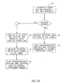
- Fig. 2B is a flow chart describing the sequence of events taking place in the updating of a location server, without reference unit being able to find enough satellites to fully determine its location;
- Fig. 3 is a flow chart describing the sequence of events taking place further to the issuance of a request to locate a mobile unit.
- In accordance with the present invention, receivers of cellular network systems are located by using ranging methods which employ transmitted signals of radio sources.
- In a system of the present invention, MUs (mobile units) are allocated for use as provisional synchronizing elements of the network. Thus, an AMU (allocated MU), according to a preferred embodiment of the present invention, when active, becomes a RMU (reference mobile unit) which constantly updates its position preferably by regular GPS oriented measurements. The present invention also provides for conditions in which a full set of satellites required by any or all the MUs involved is not available. According to an embodiment of the present invention, the RMU extracts from the navigation satellite system at least satellite system time and makes it available for synchronizing signals of a cellular network. Fig. 1 describes schematically a minimal setup in which the present invention is implemented. Signals of a
navigation satellite 10, typically a GPS satellite, are received by a MU 12 and by an RMU 14. The two mobile units also receive signals of BTSs (base stations) 16 and 18. Fig. 2A to which reference is now made, describes a sequence of events in accordance with a preferred embodiment of the invention that are carried out for the purpose of updating the location parameters of a RMU. Instep 20 the RMU attempts to locate itself by GPS only reference. These attempts are repeated until the RMU is located. Such an approach is especially suitable for mobile units situated in open areas or moving units with a portion of their path located in open places. Instep 22. The RMU measures the reception times of identifiable frames of available BTSs of a local cellular network, relative to the satellite system time signal. This will synchronize the transmission timing of the available BTSs with the satellite system time. The updated synchronization information is sent to a processing unit in a central location server of the network, as well as the location parameters of the RMU, instep 24. In another embodiment of the invention, described in Fig. 2B to which reference is now made, satellite location determination is not necessarily performed. Instep 30 an attempt is made at the RMU to determine the location referring to satellite signals only. If such is made possible, the sequence continues throughsteps 32, in measuring the reception times of identifiable timing references of available BTSs of a local cellular network, relative to the satellite system time signal. The reception times of the BTSs and satellites signals are then used as input data for ranging purposes, and will therefore be referred to generally as location data if they are not used for locating the RMU singly. Instep 33, the updated synchronization data and the location parameters of the RMU are sent to a location server of the network, to be processed by a processing unit. The synchronization between the BTSs and the satellite system time cannot be used for periods longer than a few tens of seconds because of the drift in the BTS clocks with respect to that of the satellite system. This drift is non linear and cannot be predicted, so that repeated synchronizations must be performed. For GSM systems, the various BTSs are not synchronized among themselves so that a separate matching must be performed for each base station. The clocks of the mobile units are of relative inferior stability and their respective offsets require extra measurements to be made in order to solve range equations, as is the case with regular GPS - based range finding. If no satellite location has been successfully made, the RMU locks on to at least one satellite to obtain at least system time instep 34. Consequently, instep 36 the reception time of available BTSs are measured by the local RMU clock, using satellite system time as reference. Instep 38, synchronization data and RMU location data are sent to the central processing server for further location processing. - In extreme cases in which not even one satellite can be received well enough to obtain at least system timing, it is still possible to use a AMU according to the invention. In such cases, a margin is left for exclusive use of BTSs as radio sources for ranging and for time synchronization, along the lines of the implementation of the invention disclosed in WO-99 - 21028, the contents of which are incorporated herewith by reference. In other extreme cases of the framework of the invention, the mobile unit requesting location determination may achieve the task by full satellite location procedure, which in such a case renders the mutual synchronization of BTSs redundant.
- As regards navigation satellites, downloading system time from one satellite sufficiently represents all the satellites of a navigation constellation a timing download of any other satellites because they are mutually synchronized. In the case that a RMU remains immobile, it is not necessary to do a full satellite location process constantly, even if all the required satellites for the task are available. In such a case, the system time measurement from one satellite is sufficient for use as a reference unit for the cellular system, and the RMU location should be reaffirmed at the location server.
- Upon receiving a request for location, the location server of the network sets off a sequence of steps in which new and old data are used. Fig. 3 to which reference is now made illustrates a sequence according to an embodiment of the invention. In step 40 a request to locate a MU is received in the location server of the network. In
step 42 the database is searched for updated RMU data. If no such updated data exists, instep 44 the server sends a request, such as by cell - broadcast or by SMS (short messaging service) to the AMUs for location and synchronization data. Instep 46 the location data and synchronization data is passed on to the location server. If RMU data is found instep 42, the updated synchronization and location data are collected instep 48. In each case, synchronization data and location data are sent to a location server instep 50. The actual location processing may be performed in a server of the network system, or it may be performed in the MU. - In the case that two satellites are available for the MU and a RMU, two BSTs are required for location of the MU. The satellites need not be the same satellites for the two MUs. The equation for the range (R) between MU and BTS1 is as follows:

- 1.

- 2.

- 3.

- 4.

- Four more measurements to the two satellites complete the set.
- 5.

- 6.

- 7.

- 8.

- In this set of equations there are unknown variables: two clock offsets (one for each MU), TtransBTS1, TtransBTS2 , R (AMU - GPS2), R (AMU - GPS1), R (MU - GPS2), R (MU - GPS1).
- The assignment of MUs for provisional synchronization elements of the network raises issues of protection of privacy. Upon updating of the AMU location parameters in the location server's database, a potential violation of privacy is committed. The implementation of the present invention implies therefore the application of special measures to protect privacy. As a possible remedy for the problem, the information sent to the location server's database would not contain the respective telephone numbers of the associated receivers.
Claims (11)
- A system for determining location in an unsynchronized cellular network comprising:(a) a plurality of radio sources (10, 16, 18) for sending timing references;(b) a plurality of mobile units (12, 14) of the unsynchronized cellular network, each said mobile unit capable of receiving both cellular network signals and navigation satellite signals; and(c) a location processing unit of the cellular network,said plurality of mobile units comprising:at least one first mobile unit (12) adapted to perform a first measurement of respective reception times of a plurality of radio signals bearing identifiable timing references received from said radio sources (10, 16, 18) including at least one Base Transceiver Station BTS (16, 18), andat least one second mobile unit (14) adapted to perform downloading of satellite system time and a second measurement of respective reception times of said cellular network signals, to calculate synchronization information from said second measurements and said satellite system time, and to calculate parameters related to its own location;said location processing unit being adapted to calculate a location of said first mobile unit (12) from said first measurement, said second measurement and said location parameters.
- The system of claim 1 wherein said location processing unit is a component of said first mobile unit (12).
- The system of claim 1, wherein said location processing unit is a component of a central location server.
- A method for determining location of a first mobile unit (12) in an unsynchronized cellular network comprising:a) effecting with the first mobile unit (12) first measurements of respective reception times of a plurality of radio signals bearing identifiable timing references received from a plurality of radio sources (10, 16, 18) including at least one base transceiver station BTS (16, 18);
and characterized in further comprising:b) providing a second mobile unit (14) capable of receiving both cellular network signals and navigation satellite signals;c) downloading (34) satellite system time by said second mobile unit (14);d) effecting (36) with said second mobile unit a second measurement of respective reception times of said cellular network signals;e) calculating synchronization information from said second measurements and said satellite system time;f) calculating parameters related to the location of said second mobile unit (14); andg) calculating a location of said first mobile unit (12) from said first measurements, said second measurements, and said location parameters. - The method of claim 4, wherein one of said plurality of radio sources received by said second mobile unit is a navigation satellite (10).
- The method of claim 4, wherein two of said plurality of radio sources received by said second mobile unit is a navigation satellite (10).
- The method of claim 4, wherein said parameters related to the location of said second mobile unit (14) are obtained exclusively by satellite navigation methods (30).
- The system of claim 1 wherein said second mobile unit (14) is further operative to transfer (38) said synchronization information to said location processing unit.
- The method of claim 4 further comprising:h) transferring (38) by said second mobile unit (14) to a location processing unit at least one of said satellite system time, said second measurements, said synchronization information, said location parameters and location data.
- The method of claim 4 wherein said first mobile unit (12) receives signals of at least one base station (16) received by said second mobile unit.
- The method of claim 4 wherein said calculating synchronization information is performed in at least one of said first mobile unit (12) and a server in the cellular network.
Applications Claiming Priority (3)
| Application Number | Priority Date | Filing Date | Title |
|---|---|---|---|
| US19403500P | 2000-04-03 | 2000-04-03 | |
| US194035P | 2000-04-03 | ||
| PCT/US2001/004961 WO2001076284A1 (en) | 2000-04-03 | 2001-02-16 | Distributed location system |
Publications (3)
| Publication Number | Publication Date |
|---|---|
| EP1323317A1 EP1323317A1 (en) | 2003-07-02 |
| EP1323317A4 EP1323317A4 (en) | 2004-09-08 |
| EP1323317B1 true EP1323317B1 (en) | 2006-08-23 |
Family
ID=22716037
Family Applications (1)
| Application Number | Title | Priority Date | Filing Date |
|---|---|---|---|
| EP01910783A Expired - Lifetime EP1323317B1 (en) | 2000-04-03 | 2001-02-16 | Distributed location system |
Country Status (6)
| Country | Link |
|---|---|
| US (1) | US20040005899A1 (en) |
| EP (1) | EP1323317B1 (en) |
| AT (1) | ATE337688T1 (en) |
| AU (1) | AU2001238352A1 (en) |
| DE (1) | DE60122544T2 (en) |
| WO (1) | WO2001076284A1 (en) |
Cited By (1)
| Publication number | Priority date | Publication date | Assignee | Title |
|---|---|---|---|---|
| CN104090286A (en) * | 2014-07-15 | 2014-10-08 | 江苏艾倍科科技有限公司 | Beidou Satellite search locating method and device |
Families Citing this family (8)
| Publication number | Priority date | Publication date | Assignee | Title |
|---|---|---|---|---|
| GB9722324D0 (en) * | 1997-10-22 | 1997-12-17 | Cambridge Positioning Sys Ltd | Positioning system for digital telephone networks |
| FR2841087A1 (en) * | 2002-06-18 | 2003-12-19 | Cegetel Groupe | Mobile telephone management distance placed equipment having first step providing time slot division attributes with second step server synchronization third step terminal storing specified time slots each terminal. |
| US6996403B2 (en) * | 2003-12-19 | 2006-02-07 | Motorola, Inc. | Method and apparatus for locating a remote unit |
| US7574224B2 (en) * | 2005-06-13 | 2009-08-11 | Qualcomm Incorporated | Methods and apparatus for performing timing synchronization with base stations |
| EP1901088A1 (en) * | 2006-09-18 | 2008-03-19 | Cambridge Positioning Systems Limited | Integrated mobile-terminal navigation |
| US20080254810A1 (en) * | 2006-12-05 | 2008-10-16 | Kenny Fok | Methods and Apparatus for Location Determination In A Wireless Communication Device |
| US11065021B2 (en) | 2018-10-03 | 2021-07-20 | Daniel Ezra Walzman | Osteotomy device |
| DE102021207759B4 (en) | 2021-07-20 | 2023-06-15 | Continental Automotive Technologies GmbH | Method for forwarding synchronization information in a communication device, communication device and vehicle |
Family Cites Families (12)
| Publication number | Priority date | Publication date | Assignee | Title |
|---|---|---|---|---|
| AUPN733395A0 (en) * | 1995-12-22 | 1996-01-25 | University Of Technology, Sydney | Location and tracking system |
| US5960355A (en) * | 1996-02-16 | 1999-09-28 | Telefonaktiebolaget Lm Ericsson | Method and an arrangement relating to telecommunication systems |
| US6185427B1 (en) * | 1996-09-06 | 2001-02-06 | Snaptrack, Inc. | Distributed satellite position system processing and application network |
| US5983109A (en) * | 1997-02-03 | 1999-11-09 | Northern Telecom Limited | Method and apparatus for using advanced positioning systems in cellular communications networks |
| US5973643A (en) * | 1997-04-11 | 1999-10-26 | Corsair Communications, Inc. | Method and apparatus for mobile emitter location |
| US6070078A (en) * | 1997-10-15 | 2000-05-30 | Ericsson Inc. | Reduced global positioning system receiver code shift search space for a cellular telephone system |
| EA002006B1 (en) * | 1997-10-22 | 2001-10-22 | Кэмбридж Позишнинг Системз Лтд. | Positioning system for digital telephone networks |
| US6252543B1 (en) * | 1998-05-28 | 2001-06-26 | Ericsson Inc. | Location system combining ranging measurements from GPS and cellular networks |
| GB2338374A (en) * | 1998-06-10 | 1999-12-15 | Motorola Ltd | Locating a mobile telephone using time of arrival measurements |
| US6204808B1 (en) * | 1998-08-13 | 2001-03-20 | Ericsson Inc. | Method and system for aiding GPS receivers via a cellular or PCS network |
| US6188351B1 (en) * | 1998-08-13 | 2001-02-13 | Ericsson Inc. | Method for improving signal acquistion in a global positioning system receiver |
| US6453168B1 (en) * | 1999-08-02 | 2002-09-17 | Itt Manufacturing Enterprises, Inc | Method and apparatus for determining the position of a mobile communication device using low accuracy clocks |
-
2001
- 2001-02-16 AT AT01910783T patent/ATE337688T1/en not_active IP Right Cessation
- 2001-02-16 WO PCT/US2001/004961 patent/WO2001076284A1/en not_active Ceased
- 2001-02-16 DE DE60122544T patent/DE60122544T2/en not_active Expired - Lifetime
- 2001-02-16 US US10/221,477 patent/US20040005899A1/en not_active Abandoned
- 2001-02-16 AU AU2001238352A patent/AU2001238352A1/en not_active Abandoned
- 2001-02-16 EP EP01910783A patent/EP1323317B1/en not_active Expired - Lifetime
Cited By (1)
| Publication number | Priority date | Publication date | Assignee | Title |
|---|---|---|---|---|
| CN104090286A (en) * | 2014-07-15 | 2014-10-08 | 江苏艾倍科科技有限公司 | Beidou Satellite search locating method and device |
Also Published As
| Publication number | Publication date |
|---|---|
| US20040005899A1 (en) | 2004-01-08 |
| WO2001076284A1 (en) | 2001-10-11 |
| EP1323317A4 (en) | 2004-09-08 |
| ATE337688T1 (en) | 2006-09-15 |
| AU2001238352A1 (en) | 2001-10-15 |
| DE60122544D1 (en) | 2006-10-05 |
| EP1323317A1 (en) | 2003-07-02 |
| DE60122544T2 (en) | 2007-10-04 |
Similar Documents
| Publication | Publication Date | Title |
|---|---|---|
| EP1709460B1 (en) | Transfer of calibrated time information in a mobile terminal | |
| JP5791968B2 (en) | Method and apparatus for determining position using a small number of GPS satellites and synchronous and asynchronous base stations | |
| US6433739B1 (en) | Method and apparatus for synchronizing base stations using remote synchronizing stations | |
| EP2078966B1 (en) | Satellite positioning system augmentation with wireless communication signals | |
| US6574478B1 (en) | System and method for locating mobile devices | |
| EP1279312B1 (en) | Calibration of positioning systems | |
| EP1506686B1 (en) | Improved position determination in wireless communication systems | |
| US5929806A (en) | Method for estimating a location of a mobile unit based on at least two fixed transceivers | |
| EP1717596A1 (en) | Transfer of position information to a mobile terminal | |
| US6983160B2 (en) | Base site and method for GPS-based regional time synchronization | |
| JPH10300835A (en) | Quick and accurate specification of geographical position for cellular telephone using gps satellite system | |
| KR20010041950A (en) | System and method for determining the position of a wireless cdma transceiver | |
| RU2004133331A (en) | METHOD AND DEVICE FOR MEASURING THE FREQUENCY OF A BASE STATION IN CELLULAR NETWORKS USING GSP MOBILE RECEIVERS | |
| KR20020008200A (en) | Improvements in radio positioning systems | |
| JP2004515766A (en) | Position-determination method and apparatus | |
| US8472971B2 (en) | Method and apparatus for determining whether a mobile terminal has moved outside a given locale | |
| KR20080032193A (en) | Synchronization of End User Wireless Terminal and Wireless Network | |
| US6819286B2 (en) | Location determination for mobile units | |
| US20250253968A1 (en) | Broadcast positioning system supporting location services through over-the-air television (tv) signals | |
| US20040005899A1 (en) | Distributed location system | |
| US5610615A (en) | Method and device for mobile station positioning by means of a satellite, and associated transmission method | |
| CN1507710A (en) | Method and apparatus for synchronizing base stations with mobile GPS stations | |
| EP1296467B1 (en) | Method for synchronizing terrestrial nodes equipped with GNSS receivers and belonging to a terrestrial network | |
| WO2010127681A1 (en) | Method and apparatus for determination of the positioning of an apparatus or an user from satellite signaling | |
| US6091357A (en) | Communication system and method for determining a reliability of a signal |
Legal Events
| Date | Code | Title | Description |
|---|---|---|---|
| PUAI | Public reference made under article 153(3) epc to a published international application that has entered the european phase |
Free format text: ORIGINAL CODE: 0009012 |
|
| 17P | Request for examination filed |
Effective date: 20030204 |
|
| AK | Designated contracting states |
Designated state(s): AT BE CH CY DE DK ES FI FR GB GR IE IT LI LU MC NL PT SE TR |
|
| AX | Request for extension of the european patent |
Extension state: AL LT LV MK RO SI |
|
| A4 | Supplementary search report drawn up and despatched |
Effective date: 20040727 |
|
| RIC1 | Information provided on ipc code assigned before grant |
Ipc: 7G 01S 5/14 A Ipc: 7H 04Q 7/38 B Ipc: 7G 01S 1/00 B |
|
| 17Q | First examination report despatched |
Effective date: 20041025 |
|
| GRAP | Despatch of communication of intention to grant a patent |
Free format text: ORIGINAL CODE: EPIDOSNIGR1 |
|
| RIC1 | Information provided on ipc code assigned before grant |
Ipc: H04Q 7/38 20060101ALI20060216BHEP Ipc: G01S 5/14 20060101ALI20060216BHEP Ipc: H04Q 7/20 20060101AFI20060216BHEP Ipc: G01S 1/00 20060101ALI20060216BHEP |
|
| GRAS | Grant fee paid |
Free format text: ORIGINAL CODE: EPIDOSNIGR3 |
|
| GRAA | (expected) grant |
Free format text: ORIGINAL CODE: 0009210 |
|
| AK | Designated contracting states |
Kind code of ref document: B1 Designated state(s): AT BE CH CY DE DK ES FI FR GB GR IE IT LI LU MC NL PT SE TR |
|
| PG25 | Lapsed in a contracting state [announced via postgrant information from national office to epo] |
Ref country code: NL Free format text: LAPSE BECAUSE OF FAILURE TO SUBMIT A TRANSLATION OF THE DESCRIPTION OR TO PAY THE FEE WITHIN THE PRESCRIBED TIME-LIMIT Effective date: 20060823 Ref country code: IT Free format text: LAPSE BECAUSE OF FAILURE TO SUBMIT A TRANSLATION OF THE DESCRIPTION OR TO PAY THE FEE WITHIN THE PRESCRIBED TIME-LIMIT;WARNING: LAPSES OF ITALIAN PATENTS WITH EFFECTIVE DATE BEFORE 2007 MAY HAVE OCCURRED AT ANY TIME BEFORE 2007. THE CORRECT EFFECTIVE DATE MAY BE DIFFERENT FROM THE ONE RECORDED. Effective date: 20060823 Ref country code: LI Free format text: LAPSE BECAUSE OF FAILURE TO SUBMIT A TRANSLATION OF THE DESCRIPTION OR TO PAY THE FEE WITHIN THE PRESCRIBED TIME-LIMIT Effective date: 20060823 Ref country code: CH Free format text: LAPSE BECAUSE OF FAILURE TO SUBMIT A TRANSLATION OF THE DESCRIPTION OR TO PAY THE FEE WITHIN THE PRESCRIBED TIME-LIMIT Effective date: 20060823 Ref country code: AT Free format text: LAPSE BECAUSE OF FAILURE TO SUBMIT A TRANSLATION OF THE DESCRIPTION OR TO PAY THE FEE WITHIN THE PRESCRIBED TIME-LIMIT Effective date: 20060823 Ref country code: BE Free format text: LAPSE BECAUSE OF FAILURE TO SUBMIT A TRANSLATION OF THE DESCRIPTION OR TO PAY THE FEE WITHIN THE PRESCRIBED TIME-LIMIT Effective date: 20060823 Ref country code: FI Free format text: LAPSE BECAUSE OF FAILURE TO SUBMIT A TRANSLATION OF THE DESCRIPTION OR TO PAY THE FEE WITHIN THE PRESCRIBED TIME-LIMIT Effective date: 20060823 |
|
| REG | Reference to a national code |
Ref country code: GB Ref legal event code: FG4D |
|
| REG | Reference to a national code |
Ref country code: CH Ref legal event code: EP |
|
| REG | Reference to a national code |
Ref country code: IE Ref legal event code: FG4D |
|
| REF | Corresponds to: |
Ref document number: 60122544 Country of ref document: DE Date of ref document: 20061005 Kind code of ref document: P |
|
| PG25 | Lapsed in a contracting state [announced via postgrant information from national office to epo] |
Ref country code: DK Free format text: LAPSE BECAUSE OF FAILURE TO SUBMIT A TRANSLATION OF THE DESCRIPTION OR TO PAY THE FEE WITHIN THE PRESCRIBED TIME-LIMIT Effective date: 20061123 Ref country code: SE Free format text: LAPSE BECAUSE OF FAILURE TO SUBMIT A TRANSLATION OF THE DESCRIPTION OR TO PAY THE FEE WITHIN THE PRESCRIBED TIME-LIMIT Effective date: 20061123 |
|
| PG25 | Lapsed in a contracting state [announced via postgrant information from national office to epo] |
Ref country code: ES Free format text: LAPSE BECAUSE OF FAILURE TO SUBMIT A TRANSLATION OF THE DESCRIPTION OR TO PAY THE FEE WITHIN THE PRESCRIBED TIME-LIMIT Effective date: 20061204 |
|
| PG25 | Lapsed in a contracting state [announced via postgrant information from national office to epo] |
Ref country code: PT Free format text: LAPSE BECAUSE OF FAILURE TO SUBMIT A TRANSLATION OF THE DESCRIPTION OR TO PAY THE FEE WITHIN THE PRESCRIBED TIME-LIMIT Effective date: 20070124 |
|
| NLV1 | Nl: lapsed or annulled due to failure to fulfill the requirements of art. 29p and 29m of the patents act | ||
| ET | Fr: translation filed | ||
| PG25 | Lapsed in a contracting state [announced via postgrant information from national office to epo] |
Ref country code: MC Free format text: LAPSE BECAUSE OF NON-PAYMENT OF DUE FEES Effective date: 20070228 |
|
| REG | Reference to a national code |
Ref country code: CH Ref legal event code: PL |
|
| PLBE | No opposition filed within time limit |
Free format text: ORIGINAL CODE: 0009261 |
|
| STAA | Information on the status of an ep patent application or granted ep patent |
Free format text: STATUS: NO OPPOSITION FILED WITHIN TIME LIMIT |
|
| 26N | No opposition filed |
Effective date: 20070524 |
|
| PG25 | Lapsed in a contracting state [announced via postgrant information from national office to epo] |
Ref country code: IE Free format text: LAPSE BECAUSE OF NON-PAYMENT OF DUE FEES Effective date: 20070216 |
|
| PG25 | Lapsed in a contracting state [announced via postgrant information from national office to epo] |
Ref country code: GR Free format text: LAPSE BECAUSE OF FAILURE TO SUBMIT A TRANSLATION OF THE DESCRIPTION OR TO PAY THE FEE WITHIN THE PRESCRIBED TIME-LIMIT Effective date: 20061124 |
|
| PG25 | Lapsed in a contracting state [announced via postgrant information from national office to epo] |
Ref country code: LU Free format text: LAPSE BECAUSE OF NON-PAYMENT OF DUE FEES Effective date: 20070216 Ref country code: CY Free format text: LAPSE BECAUSE OF FAILURE TO SUBMIT A TRANSLATION OF THE DESCRIPTION OR TO PAY THE FEE WITHIN THE PRESCRIBED TIME-LIMIT Effective date: 20060823 |
|
| PG25 | Lapsed in a contracting state [announced via postgrant information from national office to epo] |
Ref country code: TR Free format text: LAPSE BECAUSE OF FAILURE TO SUBMIT A TRANSLATION OF THE DESCRIPTION OR TO PAY THE FEE WITHIN THE PRESCRIBED TIME-LIMIT Effective date: 20060823 |
|
| PGFP | Annual fee paid to national office [announced via postgrant information from national office to epo] |
Ref country code: FR Payment date: 20130321 Year of fee payment: 13 Ref country code: GB Payment date: 20130222 Year of fee payment: 13 Ref country code: DE Payment date: 20130221 Year of fee payment: 13 |
|
| REG | Reference to a national code |
Ref country code: DE Ref legal event code: R119 Ref document number: 60122544 Country of ref document: DE |
|
| REG | Reference to a national code |
Ref country code: DE Ref legal event code: R079 Ref document number: 60122544 Country of ref document: DE Free format text: PREVIOUS MAIN CLASS: H04Q0007200000 Ipc: H04W0084000000 |
|
| GBPC | Gb: european patent ceased through non-payment of renewal fee |
Effective date: 20140216 |
|
| REG | Reference to a national code |
Ref country code: FR Ref legal event code: ST Effective date: 20141031 |
|
| REG | Reference to a national code |
Ref country code: DE Ref legal event code: R079 Ref document number: 60122544 Country of ref document: DE Free format text: PREVIOUS MAIN CLASS: H04Q0007200000 Ipc: H04W0084000000 Effective date: 20141022 Ref country code: DE Ref legal event code: R119 Ref document number: 60122544 Country of ref document: DE Effective date: 20140902 |
|
| PG25 | Lapsed in a contracting state [announced via postgrant information from national office to epo] |
Ref country code: DE Free format text: LAPSE BECAUSE OF NON-PAYMENT OF DUE FEES Effective date: 20140902 Ref country code: FR Free format text: LAPSE BECAUSE OF NON-PAYMENT OF DUE FEES Effective date: 20140228 Ref country code: GB Free format text: LAPSE BECAUSE OF NON-PAYMENT OF DUE FEES Effective date: 20140216 |