EP1279924A2 - Method for calculating distance using piece-wise linear interpolation - Google Patents
Method for calculating distance using piece-wise linear interpolation Download PDFInfo
- Publication number
- EP1279924A2 EP1279924A2 EP02254654A EP02254654A EP1279924A2 EP 1279924 A2 EP1279924 A2 EP 1279924A2 EP 02254654 A EP02254654 A EP 02254654A EP 02254654 A EP02254654 A EP 02254654A EP 1279924 A2 EP1279924 A2 EP 1279924A2
- Authority
- EP
- European Patent Office
- Prior art keywords
- latitude
- point
- value
- radius
- curvature
- Prior art date
- Legal status (The legal status is an assumption and is not a legal conclusion. Google has not performed a legal analysis and makes no representation as to the accuracy of the status listed.)
- Withdrawn
Links
- 238000000034 method Methods 0.000 title claims abstract description 43
- 238000011156 evaluation Methods 0.000 abstract description 6
- 238000012886 linear function Methods 0.000 abstract description 4
- 238000004364 calculation method Methods 0.000 description 8
- 238000007620 mathematical function Methods 0.000 description 3
- 238000010586 diagram Methods 0.000 description 2
- 238000012986 modification Methods 0.000 description 1
- 230000004048 modification Effects 0.000 description 1
- 230000000007 visual effect Effects 0.000 description 1
Images

Classifications
-
- G—PHYSICS
- G01—MEASURING; TESTING
- G01C—MEASURING DISTANCES, LEVELS OR BEARINGS; SURVEYING; NAVIGATION; GYROSCOPIC INSTRUMENTS; PHOTOGRAMMETRY OR VIDEOGRAMMETRY
- G01C21/00—Navigation; Navigational instruments not provided for in groups G01C1/00 - G01C19/00
- G01C21/20—Instruments for performing navigational calculations
Definitions
- the present application relates generally to a method for calculating the distance between two points.
- the method is particularly useful to the field of navigation systems wherein the accurate and efficient calculation of distances is required.
- Navigation systems are available for vehicles (such as automobiles, trucks, buses, etc.) that travel on roads. These in-vehicle navigation systems provide end users (such as drivers and/or passengers of the vehicles in which the navigation systems are installed) with various useful navigation features. For example, some navigation systems are able to determine an optimum route to be traveled by roads between locations in a geographic region. Using input from an end user and optionally from equipment that can determine one's physical location (such as a GPS system), programming in the navigation system can examine various routes between two locations to determine an optimum route to travel from a starting location to a destination location in a geographic region.
- the navigation system may then provide the end user with information about the optimum route in the form of instructions that identify the driving maneuvers required to be taken by the end user to travel from the starting location to the destination location.
- the instructions may take the form of visual and/or audio instructions that are provided along the way as the end user is travelling the route.
- navigation systems are able to show detailed maps highlighting routes to destinations, the types of maneuvers to be taken along various locations along the routes, the location of certain types of establishments and/or features, etc.
- the geographic data may be in the form of one or more databases that include data that represent physical features in a geographic region.
- the geographic databases include data representing the roads and intersections in a geographic region and also include information relating to the represented roads and intersections, such as turn restrictions at intersections, speed limits along the roads, street name of various roads, address ranges along the roads, etc.
- navigation systems provide many useful and important features, there continues to be room for improvements in these features.
- One such area in which there is room for improvement is to use a simplified method of determining the distance between two points accurately and consistently. Difficulties arise in calculating the distance between two points because the earth is not spherical in shape, but instead has an ellipsoidal geometry upon which the navigation databases are based.
- Conventional distance calculation techniques include utilizing geodetic formulas that can provide an accurate distance calculation between two points.
- certain data representing roads and intersections may be expressed in angular units in the WGS84 ellipsoidal coordinates system.
- accuracy in distance of the order of a few millimeters for a line length as long as 200 kilometers can be obtained using the equations 1-12 listed below, and which can be found in the following publication: Geometric Geodesy I, Richard H. Rapp, The Ohio State University, April 1991, pp.114-115. Equation 12 yields the desired distance between two points after evaluating different quantities as shown in equations 1-11.
- notation “a” refers to the semi-major axis of the ellipsoid
- notation “e” refers to the eccentricity of the ellipsoid, wherein the remainder of the notations are self-explanatory.
- the equations 1-12 require the evaluation of many non-linear mathematical functions to compute the distance between points. It may not be feasible to perform the evaluation of these non-linear mathematical functions repeatedly where the latitude and longitude of points are constantly changing in certain applications, such as in navigation systems. Also, it is typically not necessary to calculate the distance between points within a few millimeters of accuracy in such applications. Instead, the only requirement is that the distance should be sufficiently accurate for navigation system applications, and that the calculation of such distance should be efficient.
- D E and D N are east and north components of the distance D between the two points ( ⁇ 1 , ⁇ 1 ), and ( ⁇ 2 , ⁇ 2 ), ⁇ ⁇ is the difference in the latitude given in equation 6 above, and ⁇ is the difference in the longitude given in equation 7 above.
- the prime vertical radius of curvature (N) and the meridian radius of curvature (M) are obtained from equations 17 and 18 and, as a result, it is assumed that the earth has an ellipsoidal geometry for the latitude and longitude values in the above formulas. This is required because the latitude and longitude values for a given set of points are based upon the earth having an ellipsoidal geometry.
- an evaluation for cosine also has to be done, as its value is necessary to determine the east component of the distance between the two points. These values are needed every time the latitude coordinate changes, and a floating-point operation is required to compute these quantities, which is a very time consuming operation that must be performed in the computer of the navigation system a large number of times.
- one embodiment of the invention provides a method for calculating a distance between a first point and a second point using linear interpolation.
- the first point and the second point are located between a first latitude and a second latitude.
- An interpolated prime vertical radius of curvature value for a point between the first point and the second point is calculated based on a predetermined first prime vertical radius of curvature value for the first latitude and a second predetermined prime vertical radius of curvature value for the second latitude.
- An interpolated meridian radius of curvature value for the point between the first point and the second point is calculated based on a predetermined first meridian radius of curvature value for the first latitude and a second predetermined meridian radius of curvature value for the second latitude.
- an interpolated cosine value for the point between the first point and the second point is calculated based on a predetermined value representing a cosine of the first latitude and a predetermined value representing a cosine of the second latitude.
- the interpolated prime vertical radius of curvature value, the interpolated meridian radius of curvature value, and the interpolated cosine value can then be used in linear equations to determine the distance between the two points. This method eliminates the evaluation of non-linear functions thereby increasing efficiency and also maintaining accuracy.
- Another embodiment of the invention provides a computer readable medium including a program for calculating a distance between a first point and a second point using linear interpolation.
- the first point and the second point are located between a first latitude and a second latitude.
- the program includes computer readable program code that calculates an interpolated prime vertical radius of curvature value for a point between the first point and the second point based on a first prime vertical radius of curvature value for the first latitude and a second prime vertical radius of curvature value for the second latitude.
- the program also includes computer readable program code that calculates an interpolated meridian radius of curvature value for the point between the first point and the second point based on a first meridian radius of curvature value for the first latitude and a second meridian radius of curvature value for the second latitude.
- the program includes computer readable program code that calculates an interpolated cosine value for the point between the first point and the second point based on a value representing a cosine of the first latitude and a value representing a cosine of the second latitude.
- the program includes computer readable program code that calculates the distance between the first point and the second point based on the interpolated prime vertical radius of curvature value, the interpolated meridian radius of curvature value, and the interpolated cosine value.
- an embodiment of the present invention is directed to providing a method for determining the distance D between the two points ( ⁇ 1 , ⁇ 1 ) and ( ⁇ 2 , ⁇ 2 ) without having to calculate non-linear parameters for each and every distance calculation.
- This is accomplished by piece-wise linear interpolation, which is defined herein as estimating values of a particular parameter between two known values of that parameter.
- the prime vertical radius of curvature (N), the meridian radius of curvature (M), and the cosine function are calculated by means of linear interpolation.
- the values for the prime vertical radius of curvature (N), the meridian radius of curvature (M), and the cosine function are calculated for different interval of latitude (for example each full degree of latitude from 0 to 90 degrees). These numbers are tabulated and then stored in any suitable format such as, for example, a look-up table. These stored numbers can then be used in the linear equations discussed below to calculate the interpolated values for the prime vertical radius of curvature (N), the meridian radius of curvature (M), and the cosine function for the required point.
- FIG. 2 illustrates the relative position of a first point having an associated latitude and longitude ( ⁇ 1 , ⁇ 1 ) and a second point having an associated latitude and longitude ( ⁇ 2 , ⁇ 2 ).
- the two points ( ⁇ 1 , ⁇ 1 ), ( ⁇ 2 , ⁇ 2 ) are positioned above a first latitude ⁇ 1 and below second latitude ⁇ 2 .
- ⁇ 1 refers to the latitude south of ⁇ 1 .
- ⁇ 2 refers to the latitude north of ⁇ 2 .
- the two points ( ⁇ 1 , ⁇ 1 ), ( ⁇ 2 , ⁇ 2 ) also are positioned between a first longitude ⁇ 1 and a second longitude ⁇ 2 .
- ⁇ 1 refers to the longitude to the west of ⁇ 1 .
- ⁇ 2 refers to the longitude east of ⁇ 2 .
- D E is the east components of the distance D between points ( ⁇ 1 , ⁇ 1) and ( ⁇ 2 , ⁇ 2 ) and D N is the north component of the distance D between points ( ⁇ 1 , ⁇ 1 ) and ( ⁇ 2 , ⁇ 2 ).
- the distance D between points 12 and 14 can then be calculated using the Pythagorean theorem as follows.
- equations 19-21 are the same as equations 13-15 described above, except that equations 19-21 utilize interpolated values for the prime vertical radius of curvature (N), the meridian radius of curvature (M), and the cosine function, as will be more fully described below.
- the interpolated values are indicated in equations 19-21 as N ⁇ , M ⁇ and Cos ⁇ .
- the ⁇ symbol represents the difference between the longitude ⁇ 2 of the second point ( ⁇ 2 , ⁇ 2 ) and the longitude ⁇ 1 of the first point ( ⁇ 1 , ⁇ 1 ).
- ⁇ represents the difference between the latitude ⁇ 2 of the second point ( ⁇ 2 , ⁇ 2 ) and the latitude ⁇ 1 of the first point ( ⁇ 1 , ⁇ 1 ).
- the values for the prime radius of curvature (N), the meridian radius of curvature (M), and the cosine function are calculated for each full degree of latitude from 0 to 90 degrees and are stored in any suitable format such as, for example, a look-up table. Although in the preferred embodiment the values for (N), (M), and the cosine function are evaluated at each full degree, it should be appreciated that these values may be calculated at any suitable interval of latitude.
- N ⁇ 2 , N ⁇ 1 , M ⁇ 2 , M ⁇ 1, Cos ⁇ 2 , and Cos ⁇ 1 can be used in the following simple equations to interpolate the respective values for the required point ( ⁇ , ⁇ ), thereby avoiding evaluating non-linear functions every time for accuracy and efficiency.
- d ⁇ ⁇ 1 - ⁇ 1
- d ⁇ is equal to the difference between the latitude ⁇ 1 of the first point ( ⁇ 1, ⁇ 1 ) and the latitude ⁇ 1 south of ⁇ 1 .
- These interpolated values N ⁇ , M ⁇ , and Cos ⁇ can then be used to calculate required distance by plugging them in the simple equations 19-21 above.
- the equations 19-21 are same as equations 13-15 above, except that equations 19-21 use interpolated values for N, M, and the cosine function.
- the various symbols used in equations 19-25 are illustrated and shown in Figure 2.
- a long route may preferably be a set of segments of small length as is the case in the navigation database.
- the length of each of the segments may be determined using the linear interpolation method described above.
- the total length of the route may then be obtained by simply adding together the lengths of each of the segments. This will achieve both accuracy and efficiency.
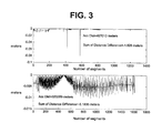
- FIG. 3 The accuracy of the linear interpolation method described in equations 19-25 as compared to the geodetic formula given above in equations 1-12 is illustrated in FIG. 3.
- Two sample set of points were evaluated as tests. Each set of points represented a line having a number of individual segments. Distances were calculated for each individual line using the geodetic formula given above (equations 1-12) and the linear interpolation formula (equations 19-25). Differences of calculated distance between the two methods for individual segments were derived. These results are shown in the top and bottom panels of Figure 3. The results show that the differences between the distances using the geodetic formula given above (equations 1-12) and the linear interpolation formula (equations 19-25) are very small.
- the present embodiment eliminates computation of all non-linear functions by using tabulated values for N ⁇ 2, N ⁇ 1 , M ⁇ 2, M ⁇ 1 , Cos ⁇ 2 , and Cos ⁇ 1 and a simple linear interpolation method to get the values for N ⁇ , M ⁇ , and Cos ⁇ for required point ( ⁇ , ⁇ ) (see FIG. 2).
- Required accuracy for distance calculations for use in a navigation system can be maintained using this method.
- the values for N ⁇ , M ⁇ , and the Cos ⁇ function for required point ( ⁇ , ⁇ ) can be obtained with sufficient accuracy using the linear interpolation method described above from the tabulated values for N, M, and cosine based on whole number of degrees of latitude from 0 to 90 degrees.
- the cosine values may preferably be truncated to an appropriate number such as, for example, 4, 5, or 6 numbers after the decimal point.
- the linear interpolation method described above may preferably use the parameters of WGS84 ellipsoid to calculate radii of curvature values for M and N.
- Use of integer arithmetic can also be applied by multiplying the tabulated cosine values by 1000000 when cosine values are truncated to the 6 th decimal place.
Landscapes
- Engineering & Computer Science (AREA)
- Radar, Positioning & Navigation (AREA)
- Remote Sensing (AREA)
- Automation & Control Theory (AREA)
- Physics & Mathematics (AREA)
- General Physics & Mathematics (AREA)
- Navigation (AREA)
- Traffic Control Systems (AREA)
- Complex Calculations (AREA)
- Image Generation (AREA)
Abstract
Description
- The present application relates generally to a method for calculating the distance between two points. The method is particularly useful to the field of navigation systems wherein the accurate and efficient calculation of distances is required.
- Navigation systems are available for vehicles (such as automobiles, trucks, buses, etc.) that travel on roads. These in-vehicle navigation systems provide end users (such as drivers and/or passengers of the vehicles in which the navigation systems are installed) with various useful navigation features. For example, some navigation systems are able to determine an optimum route to be traveled by roads between locations in a geographic region. Using input from an end user and optionally from equipment that can determine one's physical location (such as a GPS system), programming in the navigation system can examine various routes between two locations to determine an optimum route to travel from a starting location to a destination location in a geographic region. The navigation system may then provide the end user with information about the optimum route in the form of instructions that identify the driving maneuvers required to be taken by the end user to travel from the starting location to the destination location. The instructions may take the form of visual and/or audio instructions that are provided along the way as the end user is travelling the route.
- On computer displays that are part of the navigation system hardware, some navigation systems are able to show detailed maps highlighting routes to destinations, the types of maneuvers to be taken along various locations along the routes, the location of certain types of establishments and/or features, etc.
- In order to provide these types of features, navigation systems use geographic data. The geographic data may be in the form of one or more databases that include data that represent physical features in a geographic region. The geographic databases include data representing the roads and intersections in a geographic region and also include information relating to the represented roads and intersections, such as turn restrictions at intersections, speed limits along the roads, street name of various roads, address ranges along the roads, etc.
- Although navigation systems provide many useful and important features, there continues to be room for improvements in these features. One such area in which there is room for improvement is to use a simplified method of determining the distance between two points accurately and consistently. Difficulties arise in calculating the distance between two points because the earth is not spherical in shape, but instead has an ellipsoidal geometry upon which the navigation databases are based.
- Conventional distance calculation techniques include utilizing geodetic formulas that can provide an accurate distance calculation between two points. For example, certain data representing roads and intersections may be expressed in angular units in the WGS84 ellipsoidal coordinates system. Given the latitude and longitude of two points (φ1, λ1), and (φ2, λ2), accuracy in distance of the order of a few millimeters for a line length as long as 200 kilometers can be obtained using the equations 1-12 listed below, and which can be found in the following publication: Geometric Geodesy I, Richard H. Rapp, The Ohio State University, April 1991, pp.114-115. Equation 12 yields the desired distance between two points after evaluating different quantities as shown in equations 1-11. The notation "a" refers to the semi-major axis of the ellipsoid, while notation "e" refers to the eccentricity of the ellipsoid, wherein the remainder of the notations are self-explanatory.


- As shown above, the equations 1-12 require the evaluation of many non-linear mathematical functions to compute the distance between points. It may not be feasible to perform the evaluation of these non-linear mathematical functions repeatedly where the latitude and longitude of points are constantly changing in certain applications, such as in navigation systems. Also, it is typically not necessary to calculate the distance between points within a few millimeters of accuracy in such applications. Instead, the only requirement is that the distance should be sufficiently accurate for navigation system applications, and that the calculation of such distance should be efficient.
- For efficiency, it is necessary to reduce the use of non-linear mathematical functions to the extent possible. As the distances to be determined in conventional navigational system applications are typically not very long, the use of simple formulas and the Pythagorean theorem have been and can be used and still maintain the required level of efficiency and accuracy. Such simple formulas are given below in equations 13-15, although there are certain drawbacks to using these equations as well, which will be discussed below.


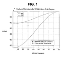
- DE and DN are east and north components of the distance D between the two points (φ1, λ1), and (φ2, λ2), Δφ is the difference in the latitude given in equation 6 above, and Δλ is the difference in the longitude given in equation 7 above. The prime vertical radius of curvature (N) and the meridian radius of curvature (M) are obtained from equations 17 and 18 and, as a result, it is assumed that the earth has an ellipsoidal geometry for the latitude and longitude values in the above formulas. This is required because the latitude and longitude values for a given set of points are based upon the earth having an ellipsoidal geometry. Evaluations of radii of curvature for prime vertical (N) and meridian (M) therefore are performed for the given points in the above formulas. Again, the notation "a" refers to the semi-major axis of the ellipsoid, while notation "e" refers to the eccentricity of the ellipsoid. The prime vertical radius of curvature (N) and the meridian radius of curvature (M) are a function of latitude, and their variations from 0 to 90 degrees is shown in Figure 1. As a result, equations 13 and 14 cannot be replaced with a model of the earth having a spherical geometry. Moreover, as shown in equation 13, an evaluation for cosine also has to be done, as its value is necessary to determine the east component of the distance between the two points. These values are needed every time the latitude coordinate changes, and a floating-point operation is required to compute these quantities, which is a very time consuming operation that must be performed in the computer of the navigation system a large number of times.
- Accordingly, it would be desirable to have a method for calculating the distance between two points for use in navigation system that overcomes the disadvantages described above.
- In order to provide an improved method of calculating the distance between two points for use in a navigation system that overcomes the above-stated disadvantages, one embodiment of the invention provides a method for calculating a distance between a first point and a second point using linear interpolation. The first point and the second point are located between a first latitude and a second latitude. An interpolated prime vertical radius of curvature value for a point between the first point and the second point is calculated based on a predetermined first prime vertical radius of curvature value for the first latitude and a second predetermined prime vertical radius of curvature value for the second latitude. An interpolated meridian radius of curvature value for the point between the first point and the second point is calculated based on a predetermined first meridian radius of curvature value for the first latitude and a second predetermined meridian radius of curvature value for the second latitude. Finally, an interpolated cosine value for the point between the first point and the second point is calculated based on a predetermined value representing a cosine of the first latitude and a predetermined value representing a cosine of the second latitude. The interpolated prime vertical radius of curvature value, the interpolated meridian radius of curvature value, and the interpolated cosine value can then be used in linear equations to determine the distance between the two points. This method eliminates the evaluation of non-linear functions thereby increasing efficiency and also maintaining accuracy.
- Another embodiment of the invention provides a computer readable medium including a program for calculating a distance between a first point and a second point using linear interpolation. The first point and the second point are located between a first latitude and a second latitude. The program includes computer readable program code that calculates an interpolated prime vertical radius of curvature value for a point between the first point and the second point based on a first prime vertical radius of curvature value for the first latitude and a second prime vertical radius of curvature value for the second latitude. The program also includes computer readable program code that calculates an interpolated meridian radius of curvature value for the point between the first point and the second point based on a first meridian radius of curvature value for the first latitude and a second meridian radius of curvature value for the second latitude. In addition, the program includes computer readable program code that calculates an interpolated cosine value for the point between the first point and the second point based on a value representing a cosine of the first latitude and a value representing a cosine of the second latitude. Finally, the program includes computer readable program code that calculates the distance between the first point and the second point based on the interpolated prime vertical radius of curvature value, the interpolated meridian radius of curvature value, and the interpolated cosine value.
- The invention provides the foregoing and other features, and the advantages of the invention will become further apparent from the following detailed description of the presently preferred embodiments, read in conjunction with the accompanying drawings. The detailed description and drawings are merely illustrative of the invention and do not limit the scope of the invention, which is defined by the appended claims and equivalents thereof.
-
- FIG. 1 is a graph illustrating the variation between the prime vertical radius of curvature (N) and the meridian radius of curvature (M) from 0-90 degrees;
- FIG. 2 is a diagram illustrating the various quantities used to calculate the distance between two points using linear interpolation in accordance with the present invention; and
- FIG. 3 is a diagram illustrating the difference in accuracy between the distance calculation using conventional geodetic formula set forth in equations 1-12 and the distance calculation using linear interpolation in accordance with the present invention (equations 19-25 below).
- As discussed above, one major drawback to calculating the distance between two points by evaluating equations 13-18 above is that the prime vertical radius of curvature (N), the meridian radius of curvature (M), and the cosine function are non-linear parameters that must be calculated via a time consuming floating point operation every time the latitude coordinate changes. As a result, evaluating equations 13-18 may not provide an efficient means to calculate distances for use in navigation systems.
- Referring now to FIG. 2, an embodiment of the present invention is directed to providing a method for determining the distance D between the two points (φ1, λ1) and (φ2, λ2) without having to calculate non-linear parameters for each and every distance calculation. This is accomplished by piece-wise linear interpolation, which is defined herein as estimating values of a particular parameter between two known values of that parameter. In a preferred embodiment, the prime vertical radius of curvature (N), the meridian radius of curvature (M), and the cosine function are calculated by means of linear interpolation. In order to accomplish this, the values for the prime vertical radius of curvature (N), the meridian radius of curvature (M), and the cosine function are calculated for different interval of latitude (for example each full degree of latitude from 0 to 90 degrees). These numbers are tabulated and then stored in any suitable format such as, for example, a look-up table. These stored numbers can then be used in the linear equations discussed below to calculate the interpolated values for the prime vertical radius of curvature (N), the meridian radius of curvature (M), and the cosine function for the required point.
- FIG. 2 illustrates the relative position of a first point having an associated latitude and longitude (φ1, λ1) and a second point having an associated latitude and longitude (φ2, λ2). In the embodiment shown, for example, the two points (φ1, λ1), (φ2, λ2) are positioned above a first latitude Φ1 and below second latitude Φ2. In particular, Φ1 refers to the latitude south of φ1. Similarly, Φ2 refers to the latitude north of φ2. The two points (φ1,λ1), (φ2,λ2) also are positioned between a first longitude Λ1 and a second longitude Λ2. In particular, Λ1 refers to the longitude to the west of λ1. Similarly, Λ2 refers to the longitude east of λ2. DE is the east components of the distance D between points (φ1,λ1) and (φ2,λ2) and DN is the north component of the distance D between points (φ1,λ1) and (φ2, λ2). A preferred embodiment of the present invention utilizes the following equations to calculate the distances DE and DN shown in FIG. 2:


- As stated above, the values for the prime radius of curvature (N), the meridian radius of curvature (M), and the cosine function are calculated for each full degree of latitude from 0 to 90 degrees and are stored in any suitable format such as, for example, a look-up table. Although in the preferred embodiment the values for (N), (M), and the cosine function are evaluated at each full degree, it should be appreciated that these values may be calculated at any suitable interval of latitude. These tabulated values, referred to below as N Φ 2, N Φ 1, M Φ 2, M Φ 1, Cos Φ 2, and Cos Φ 1, can be used in the following simple equations to interpolate the respective values for the required point (Φ, Λ), thereby avoiding evaluating non-linear functions every time for accuracy and efficiency.


- As shown FIG. 2, d Φ is equal to the difference between the latitude φ1 of the first point (φ1,λ1) and the latitude Φ1 south of φ1. These interpolated values N Φ, M Φ, and Cos Φ can then be used to calculate required distance by plugging them in the simple equations 19-21 above. As noted above, the equations 19-21 are same as equations 13-15 above, except that equations 19-21 use interpolated values for N, M, and the cosine function. The various symbols used in equations 19-25 are illustrated and shown in Figure 2.
- Those of ordinary skill in the art will appreciate that the method of calculating the distance between two points using the linear interpolation method described above could be used to calculate the distance of very long routes. In particular, a long route may preferably be a set of segments of small length as is the case in the navigation database. The length of each of the segments may be determined using the linear interpolation method described above. The total length of the route may then be obtained by simply adding together the lengths of each of the segments. This will achieve both accuracy and efficiency.
- The accuracy of the linear interpolation method described in equations 19-25 as compared to the geodetic formula given above in equations 1-12 is illustrated in FIG. 3. Two sample set of points were evaluated as tests. Each set of points represented a line having a number of individual segments. Distances were calculated for each individual line using the geodetic formula given above (equations 1-12) and the linear interpolation formula (equations 19-25). Differences of calculated distance between the two methods for individual segments were derived. These results are shown in the top and bottom panels of Figure 3. The results show that the differences between the distances using the geodetic formula given above (equations 1-12) and the linear interpolation formula (equations 19-25) are very small. The sum of all the distances was also obtained from both methods, which is also shown in Figure 3 in text. The distance between the two methods is within a few meters in distance for a total line length of more than 300 kilometers in both cases. The results show that it is possible to obtain a very accurate distance using the present linear interpolation method.
- As demonstrated above, the present embodiment eliminates computation of all non-linear functions by using tabulated values for N Φ 2, N Φ 1, M Φ 2, M Φ 1, Cos Φ 2, and Cos Φ 1 and a simple linear interpolation method to get the values for N Φ , M Φ , and Cos Φ for required point (Φ, Λ) (see FIG. 2). Required accuracy for distance calculations for use in a navigation system can be maintained using this method. The values for N Φ, M Φ, and the Cos Φ function for required point (Φ, Λ) can be obtained with sufficient accuracy using the linear interpolation method described above from the tabulated values for N, M, and cosine based on whole number of degrees of latitude from 0 to 90 degrees. To keep the table of the cosine values accurate enough and relatively manageable in size, the cosine values may preferably be truncated to an appropriate number such as, for example, 4, 5, or 6 numbers after the decimal point.
- The linear interpolation method described above may preferably use the parameters of WGS84 ellipsoid to calculate radii of curvature values for M and N. Use of integer arithmetic can also be applied by multiplying the tabulated cosine values by 1000000 when cosine values are truncated to the 6th decimal place.
- While the embodiments of the invention disclosed herein are presently considered to be preferred, various changes and modifications can be made without departing from the spirit and scope of the invention. The scope of the invention is indicated in the appended claims, and all changes that come within the meaning and range of equivalents are intended to be embraced therein.
Claims (36)
- A method for calculating a distance between a first point and a second point using linear interpolation, the first point and the second point located between a first latitude and a second latitude comprising:calculating an interpolated prime vertical radius of curvature value for a point between the first point and the second point based on a first prime vertical radius of curvature value for the first latitude and a second prime vertical radius of curvature value for the second latitude;calculating an interpolated meridian radius of curvature value for the point between the first point and the second point based on a first meridian radius of curvature value for the first latitude and a second meridian radius of curvature value for the second latitude;calculating an interpolated cosine value for the point between the first point and the second point based on a value representing a cosine of the first latitude and a value representing a cosine of the second latitude; andcalculating the distance between the first point and the second point based on the interpolated prime vertical radius of curvature value, the interpolated meridian radius of curvature value, and the interpolated cosine value.
- The method of claim 1 further comprising:determining the first prime vertical radius of curvature value for the first latitude;determining the second prime vertical radius of curvature value for the second latitude;determining the first meridian radius of curvature value for the first latitude;determining the second meridian radius of curvature value for the second latitude;determining the value representing the cosine of the first latitude; anddetermining the value representing the cosine of the second latitude.
- The method of claim 2 further comprising:storing the first prime vertical radius of curvature value for the first latitude;storing the second prime vertical radius of curvature value for the second latitude;storing the first meridian radius of curvature value for the first latitude;storing the second meridian radius of curvature value for the second latitude;storing the value representing the cosine of the first latitude; andstoring the value representing the cosine of the second latitude.
- The method of claim 1 wherein the first point has an associated latitude and longitude and the second point has an associated latitude and longitude and further comprising:calculating the difference between the latitude of the first point and the first latitude.
- The method of claim 4 further comprising:calculating the difference between the second prime vertical radius of curvature value for the second latitude and the first prime vertical radius of curvature value for the first latitude;multiplying the difference between the second prime vertical radius of curvature value for the second latitude and the first prime vertical radius of curvature value for the first latitude by the difference between the latitude of the first point and the first latitude to obtain a first value; andadding the first prime vertical radius of curvature value for the first latitude to the first value to obtain the interpolated prime vertical radius of curvature value.
- The method of claim 4 further comprising;calculating the difference between the second meridian radius of curvature value for the second latitude and the first meridian radius of curvature value for the first latitude;multiplying the difference between the second meridian radius of curvature value for the second latitude and the first meridian radius of curvature value for the first latitude by the difference between the latitude of the first point and the first latitude to obtain a second value; andadding the first meridian radius of curvature value for the first latitude to the second value to obtain the interpolated meridian radius of curvature value.
- The method of claim 4 further comprising:calculating the difference between the value representing the cosine of the second latitude and the value representing the cosine of the first latitude;multiplying the difference between the value representing the cosine of the second latitude and the value representing the cosine of the first latitude by the difference between the latitude of the first point and the first latitude to obtain a third value; andadding the value representing the cosine of the first latitude to the third value to obtain the interpolated cosine value.
- The method of claim 1 further comprising:calculating an east component of the distance between the first and second points based on the interpolated prime vertical radius of curvature value and the interpolated cosine value.
- The method of claim 8 further comprising:calculating the difference between the longitude of the second point and the longitude of the first point; andmultiplying the difference between longitude of the second point and the longitude of the first point by the interpolated cosine value and by the interpolated prime vertical radius of curvature value to obtain the east component of the distance between the first and second points.
- The method of claim 9 further comprising:calculating a north component of the distance between the first and second points based on the interpolated meridian radius of curvature value.
- The method of claim 10 further comprising:calculating the difference between the latitude of the second point and the latitude of the first point; andmultiplying the difference between latitude of the second point and the latitude of the first point by the interpolated meridian radius of curvature value to obtain the north component of the distance between the first and second points.
- The method of claim 11 further comprising;calculating the square of the east component of the distance between the first and second points;calculating the square of the north component of the distance between the first and second points;adding the square of the east component of the distance between the first and second points to the square of the north component of the distance between the first and second points to obtain a sum of the east and north components;calculating the square root of the sum of the east and north components to obtain the distance between the first and second points.
- The method of claim 1 wherein the point between the first point and the second point is a midpoint between the first and second points.
- The method of claim 1 wherein the first latitude and the second latitude and separated by an integer multiple of approximately one degree.
- The method of claim 1 further comprising:providing a navigation system wherein the distance between the first point and the second point is calculated by the navigation system.
- A computer readable medium including a program for calculating a distance between a first point and a second point using linear interpolation, the first point and the second point located between a first latitude and a second latitude, the program comprising:computer readable program code that calculates an interpolated prime vertical radius of curvature value for a point between the first point and the second point based on a first prime vertical radius of curvature value for the first latitude and a second prime vertical radius of curvature value for the second latitude;computer readable program code that calculates an interpolated meridian radius of curvature value for the point between the first point and the second point based on a first meridian radius of curvature value for the first latitude and a second meridian radius of curvature value for the second latitude;computer readable program code that calculates an interpolated cosine value for the point between the first point and the second point based on a value representing a cosine of the first latitude and a value representing a cosine of the second latitude; andcomputer readable program code that calculates the distance between the first point and the second point based on the interpolated prime vertical radius of curvature value, the interpolated meridian radius of curvature value, and the interpolated cosine value.
- The program of claim 16 further comprising computer readable program code that:determines the first prime vertical radius of curvature value for the first latitude;determines the second prime vertical radius of curvature value for the second latitude;determines the first meridian radius of curvature value for the first latitude;determines the second meridian radius of curvature value for the second latitude;determines the value representing the cosine of the first latitude; anddetermines the value representing the cosine of the second latitude.
- The program of claim 17 further comprising computer readable program code that:stores the first prime vertical radius of curvature value for the first latitude;stores the second prime vertical radius of curvature value for the second latitude;stores the first meridian radius of curvature value for the first latitude;stores the second meridian radius of curvature value for the second latitude;stores the value representing the cosine of the first latitude; andstores the value representing the cosine of the second latitude.
- The program claim 16 wherein the first point has an associated latitude and longitude and the second point has an associated latitude and longitude and further comprising computer readable program code that calculates the difference between the latitude of the first point and the first latitude.
- The program of claim 19 further comprising computer readable program code that:calculates the difference between the second prime vertical radius of curvature value for the second latitude and the first prime vertical radius of curvature value for the first latitude;multiplies the difference between the second prime vertical radius of curvature value for the second latitude and the first prime vertical radius of curvature value for the first latitude by the difference between the latitude of the first point and the first latitude to obtain a first value; andadds the first prime vertical radius of curvature value for the first latitude to the first value to obtain the interpolated prime vertical radius of curvature value.
- The program of claim 19 further comprising computer readable program code that:calculates the difference between the second meridian radius of curvature value for the second latitude and the first meridian radius of curvature value for the first latitude;multiplies the difference between the second meridian radius of curvature value for the second latitude and the first meridian radius of curvature value for the first latitude by the difference between the latitude of the first point and the first latitude to obtain a second value; andadds the first meridian radius of curvature value for the first latitude to the second value to obtain the interpolated meridian radius of curvature value.
- The program of claim 19 further comprising computer readable program code that:calculates the difference between the value representing the cosine of the second latitude and the value representing the cosine of the first latitude;multiplies the difference between the value representing the cosine of the second latitude and the value representing the cosine of the first latitude by the difference between the latitude of the first point and the first latitude to obtain a third value; andadds the value representing the cosine of the first latitude to the third value to obtain the interpolated cosine value.
- The program of claim 16 further comprising computer readable program code that calculates an east component of the distance between the first and second points based on the interpolated prime vertical radius of curvature value and the interpolated cosine value.
- The program of claim 23 further comprising computer readable program code that:calculates the difference between the longitude of the second point and the longitude of the first point; andmultiplies the difference between longitude of the second point and the longitude of the first point by the interpolated cosine value and by the interpolated prime vertical radius of curvature value to obtain the east component of the distance between the first and second points.
- The program of claim 24 further comprising computer readable program code that calculates a north component of the distance between the first and second points based on the interpolated meridian radius of curvature value.
- The program of claim 25 further comprising computer readable program code that:calculates the difference between the latitude of the second point and the latitude of the first point; andmultiplies the difference between latitude of the second point and the latitude of the first point by the interpolated meridian radius of curvature value to obtain the north component of the distance between the first and second points.
- The program of claim 26 further comprising computer readable program code that:calculates the square of the east component of the distance between the first and second points;calculates the square of the north component of the distance between the first and second points;adds the square of the east component of the distance between the first and second points to the square of the north component of the distance between the first and second points to obtain a sum of the east and north components;calculates the square root of the sum of the east and north components to obtain the distance between the first and second points.
- The program of claim 16 wherein the point between the first point and the second point is a midpoint between the first and second points.
- The program of claim 16 wherein the first latitude and the second latitude and separated by an integer multiple of approximately one degree.
- A method for calculating a distance between a first point and a second point, the first point and the second point located between a first latitude and a second latitude comprising:calculating an estimated prime vertical radius of curvature value for a point between the first point and the second point based on a first prime vertical radius of curvature value for the first latitude and a second prime vertical radius of curvature value for the second latitude;calculating an estimated meridian radius of curvature value for the point between the first point and the second point based on a first meridian radius of curvature value for the first latitude and a second meridian radius of curvature value for the second latitude;calculating an estimated cosine value for the point between the first point and the second point based on a value representing a cosine of the first latitude and a value representing a cosine of the second latitude; andcalculating the distance between the first point and the second point based on the estimated prime vertical radius of curvature value, the estimated meridian radius of curvature value, and the estimated cosine value.
- A method for calculating a distance between a first point and a second point using linear interpolation comprising:preparing a lookup table of stored values, the stored values including prime vertical radius of curvature values for a selected interval of latitude, meridian radius of curvature values for the selected interval of latitude, and cosine function values for the selected interval of latitude wherein the stored values are used to calculate the distance between the first point and the second point using linear interpolation.
- A method for calculating a distance between a first point and a second point using linear interpolation comprising:providing a navigation system;providing a lookup table of stored values, the stored values including prime vertical radius of curvature values for a selected interval of latitude, meridian radius of curvature values for the selected interval of latitude, and cosine function values for the selected interval of latitude; andstoring the lookup table in the navigation system to allow the navigation system to calculate the distance between the first point and the second point using linear interpolation.
- A navigation system for calculating a distance between a first point and a second point using linear interpolation comprising:a lookup table of stored values, the stored values including prime vertical radius of curvature values for a selected interval of latitude, meridian radius of curvature values for the selected interval of latitude, and cosine function values for the selected interval of latitude wherein the navigation system uses the lookup table of stored values to calculate the distance between the first point and the second point using linear interpolation.
- A computer readable medium for use in calculating a distance between a first point and a second point using linear interpolation comprising:a lookup table of stored values, the stored values including prime vertical radius of curvature values for a selected interval of latitude, meridian radius of curvature values for the selected interval of latitude, and cosine function values for the selected interval of latitude, to allow a navigation system to use the lookup table of stored values to calculate the distance between the first point and the second point using linear interpolation.
- A method for calculating a distance between a first point and a second point using linear interpolation comprising:providing a lookup table of stored values, the stored values including prime vertical radius of curvature values for a selected interval of latitude, meridian radius of curvature values for the selected interval of latitude, and cosine function values for the selected interval of latitude; andcompiling a geographic database that includes stored values for distances between points using the lookup table of stored values.
- The invention of claim 31, 32, 33, 34, or 35 wherein the selected interval of latitude is approximately 1 degree.
Applications Claiming Priority (2)
| Application Number | Priority Date | Filing Date | Title |
|---|---|---|---|
| US911890 | 1992-07-10 | ||
| US09/911,890 US6571195B2 (en) | 2001-07-24 | 2001-07-24 | Method for calculating distance using piece-wise linear interpolation |
Publications (2)
| Publication Number | Publication Date |
|---|---|
| EP1279924A2 true EP1279924A2 (en) | 2003-01-29 |
| EP1279924A3 EP1279924A3 (en) | 2012-02-15 |
Family
ID=25431054
Family Applications (1)
| Application Number | Title | Priority Date | Filing Date |
|---|---|---|---|
| EP02254654A Withdrawn EP1279924A3 (en) | 2001-07-24 | 2002-07-02 | Method for calculating distance using piece-wise linear interpolation |
Country Status (3)
| Country | Link |
|---|---|
| US (1) | US6571195B2 (en) |
| EP (1) | EP1279924A3 (en) |
| JP (2) | JP4287626B2 (en) |
Families Citing this family (6)
| Publication number | Priority date | Publication date | Assignee | Title |
|---|---|---|---|---|
| JP4610968B2 (en) * | 2004-08-26 | 2011-01-12 | 有限会社長谷川商事 | Position calculation apparatus, position calculation method, position calculation program, and storage medium for position calculation program |
| US20080094278A1 (en) * | 2006-10-19 | 2008-04-24 | International Business Machines Corporation | Method and system for distance estimation |
| JP5132731B2 (en) * | 2010-08-16 | 2013-01-30 | 有限会社長谷川商事 | Position calculation apparatus, position calculation method, position calculation program, and storage medium for position calculation program |
| JP5565513B1 (en) | 2013-01-08 | 2014-08-06 | 日本電気株式会社 | Coordinate transformation device, coordinate transformation program, and coordinate transformation method |
| US10814842B2 (en) * | 2016-12-28 | 2020-10-27 | Hydro-Aire, Inc. | System and method for simplified aircraft brake distance estimation |
| CN118758251B (en) * | 2024-06-11 | 2025-08-29 | 北京全路通信信号研究设计院集团有限公司 | Method and device for determining distance based on longitude and latitude |
Citations (1)
| Publication number | Priority date | Publication date | Assignee | Title |
|---|---|---|---|---|
| WO1997014933A2 (en) | 1995-10-18 | 1997-04-24 | The Charles Machine Works, Inc. | Electronic compass |
Family Cites Families (5)
| Publication number | Priority date | Publication date | Assignee | Title |
|---|---|---|---|---|
| JP3640433B2 (en) * | 1995-06-01 | 2005-04-20 | 池上通信機株式会社 | ANTENNA DIRECTION DIRECTION CALCULATION METHOD AND ANTENNA DIRECTION DIRECTION CONTROL DEVICE |
| US5614913A (en) | 1995-06-07 | 1997-03-25 | Trimble Navigation | Optimization of survey coordinate transformations |
| US6092022A (en) | 1997-02-28 | 2000-07-18 | Trimble Navigation | Optimal survey map projection system |
| US5978744A (en) | 1998-04-27 | 1999-11-02 | Trimble Navigation Ltd. | Interpolation of survey coordinate differences |
| JP3473510B2 (en) | 1999-07-21 | 2003-12-08 | 株式会社デンソー | Map display device |
-
2001
- 2001-07-24 US US09/911,890 patent/US6571195B2/en not_active Expired - Fee Related
-
2002
- 2002-07-02 EP EP02254654A patent/EP1279924A3/en not_active Withdrawn
- 2002-07-24 JP JP2002214712A patent/JP4287626B2/en not_active Expired - Fee Related
-
2009
- 2009-01-05 JP JP2009000448A patent/JP4684333B2/en not_active Expired - Fee Related
Patent Citations (1)
| Publication number | Priority date | Publication date | Assignee | Title |
|---|---|---|---|---|
| WO1997014933A2 (en) | 1995-10-18 | 1997-04-24 | The Charles Machine Works, Inc. | Electronic compass |
Also Published As
| Publication number | Publication date |
|---|---|
| US6571195B2 (en) | 2003-05-27 |
| JP4684333B2 (en) | 2011-05-18 |
| JP4287626B2 (en) | 2009-07-01 |
| JP2003065787A (en) | 2003-03-05 |
| JP2009080136A (en) | 2009-04-16 |
| US20030036880A1 (en) | 2003-02-20 |
| EP1279924A3 (en) | 2012-02-15 |
Similar Documents
| Publication | Publication Date | Title |
|---|---|---|
| EP2261606B1 (en) | Navigation map creation system | |
| US6175801B1 (en) | Navigation system map panning directional indicator | |
| EP1445583B1 (en) | Navigation system with progression indication | |
| US5902350A (en) | Generating a maneuver at the intersection through a turn lane | |
| US5471393A (en) | Driver's associate: a system for vehicle navigation and driving assistance | |
| US4403291A (en) | Self-sufficient navigation device for street vehicles | |
| JP3217754B2 (en) | Method and apparatus for indicating current vehicle position | |
| EP1078222B1 (en) | Method for displaying a current vehicle location using a navigation system | |
| US10677598B2 (en) | Map-centric map matching method and apparatus | |
| US20120245849A1 (en) | Digital map signpost system | |
| EP2045793A1 (en) | Map display system | |
| EP1367368B1 (en) | Bearing data for route guidance | |
| JP4684333B2 (en) | Distance calculation method using piecewise linear interpolation | |
| US20020169546A1 (en) | Apparatus and method for creating a navigation map | |
| US12607469B2 (en) | Method, apparatus, and computer program product for estimating a time-of-arrival at a destination | |
| JP2003254768A (en) | Navigation device and navigation method | |
| Claussen | Vehicle navigation systems | |
| KR100545925B1 (en) | Surveying method of facility around the road using a GPS receiver and a vehicle equipped with a laser measuring instrument | |
| AU3863299A (en) | A navigation system map panning directional indicator |
Legal Events
| Date | Code | Title | Description |
|---|---|---|---|
| PUAI | Public reference made under article 153(3) epc to a published international application that has entered the european phase |
Free format text: ORIGINAL CODE: 0009012 |
|
| AK | Designated contracting states |
Designated state(s): AT BE BG CH CY CZ DE DK EE ES FI FR GB GR IE IT LI LU MC NL PT SE SK TR |
|
| AX | Request for extension of the european patent |
Extension state: AL LT LV MK RO SI |
|
| RAP1 | Party data changed (applicant data changed or rights of an application transferred) |
Owner name: NAVTEQ NORTH AMERICA, LLC |
|
| RAP1 | Party data changed (applicant data changed or rights of an application transferred) |
Owner name: NAVTEQ NORTH AMERICA, LLC |
|
| PUAL | Search report despatched |
Free format text: ORIGINAL CODE: 0009013 |
|
| RIC1 | Information provided on ipc code assigned before grant |
Ipc: G01C 21/20 20060101AFI20111228BHEP |
|
| AK | Designated contracting states |
Kind code of ref document: A3 Designated state(s): AT BE BG CH CY CZ DE DK EE ES FI FR GB GR IE IT LI LU MC NL PT SE SK TR |
|
| AX | Request for extension of the european patent |
Extension state: AL LT LV MK RO SI |
|
| RIC1 | Information provided on ipc code assigned before grant |
Ipc: G01C 21/20 20060101AFI20120111BHEP |
|
| 17P | Request for examination filed |
Effective date: 20120718 |
|
| AKX | Designation fees paid |
Designated state(s): AT BE BG CH CY CZ DE DK EE ES FI FR GB GR IE IT LI LU MC NL PT SE SK TR |
|
| 17Q | First examination report despatched |
Effective date: 20121010 |
|
| GRAP | Despatch of communication of intention to grant a patent |
Free format text: ORIGINAL CODE: EPIDOSNIGR1 |
|
| RAP1 | Party data changed (applicant data changed or rights of an application transferred) |
Owner name: NAVTEQ B.V. |
|
| RAP1 | Party data changed (applicant data changed or rights of an application transferred) |
Owner name: HERE GLOBAL B.V. |
|
| GRAP | Despatch of communication of intention to grant a patent |
Free format text: ORIGINAL CODE: EPIDOSNIGR1 |
|
| INTG | Intention to grant announced |
Effective date: 20130910 |
|
| STAA | Information on the status of an ep patent application or granted ep patent |
Free format text: STATUS: THE APPLICATION IS DEEMED TO BE WITHDRAWN |
|
| 18D | Application deemed to be withdrawn |
Effective date: 20140121 |