EP1260829A1 - Autonome Kalibrierung einer drahtlosen globalen Navigationsanlage - Google Patents
Autonome Kalibrierung einer drahtlosen globalen Navigationsanlage Download PDFInfo
- Publication number
- EP1260829A1 EP1260829A1 EP01310535A EP01310535A EP1260829A1 EP 1260829 A1 EP1260829 A1 EP 1260829A1 EP 01310535 A EP01310535 A EP 01310535A EP 01310535 A EP01310535 A EP 01310535A EP 1260829 A1 EP1260829 A1 EP 1260829A1
- Authority
- EP
- European Patent Office
- Prior art keywords
- communication device
- mobile communication
- signals
- database
- wireless mobile
- Prior art date
- Legal status (The legal status is an assumption and is not a legal conclusion. Google has not performed a legal analysis and makes no representation as to the accuracy of the status listed.)
- Ceased
Links
Images


Classifications
-
- H—ELECTRICITY
- H04—ELECTRIC COMMUNICATION TECHNIQUE
- H04W—WIRELESS COMMUNICATION NETWORKS
- H04W24/00—Supervisory, monitoring or testing arrangements
-
- G—PHYSICS
- G01—MEASURING; TESTING
- G01S—RADIO DIRECTION-FINDING; RADIO NAVIGATION; DETERMINING DISTANCE OR VELOCITY BY USE OF RADIO WAVES; LOCATING OR PRESENCE-DETECTING BY USE OF THE REFLECTION OR RERADIATION OF RADIO WAVES; ANALOGOUS ARRANGEMENTS USING OTHER WAVES
- G01S5/00—Position-fixing by co-ordinating two or more direction or position line determinations; Position-fixing by co-ordinating two or more distance determinations
- G01S5/02—Position-fixing by co-ordinating two or more direction or position line determinations; Position-fixing by co-ordinating two or more distance determinations using radio waves
- G01S5/0252—Radio frequency fingerprinting
- G01S5/02521—Radio frequency fingerprinting using a radio-map
- G01S5/02524—Creating or updating the radio-map
- G01S5/02527—Detecting or resolving anomalies in the radio frequency fingerprints of the radio-map
-
- G—PHYSICS
- G01—MEASURING; TESTING
- G01S—RADIO DIRECTION-FINDING; RADIO NAVIGATION; DETERMINING DISTANCE OR VELOCITY BY USE OF RADIO WAVES; LOCATING OR PRESENCE-DETECTING BY USE OF THE REFLECTION OR RERADIATION OF RADIO WAVES; ANALOGOUS ARRANGEMENTS USING OTHER WAVES
- G01S5/00—Position-fixing by co-ordinating two or more direction or position line determinations; Position-fixing by co-ordinating two or more distance determinations
- G01S5/02—Position-fixing by co-ordinating two or more direction or position line determinations; Position-fixing by co-ordinating two or more distance determinations using radio waves
- G01S5/0257—Hybrid positioning
- G01S5/0268—Hybrid positioning by deriving positions from different combinations of signals or of estimated positions in a single positioning system
-
- G—PHYSICS
- G01—MEASURING; TESTING
- G01S—RADIO DIRECTION-FINDING; RADIO NAVIGATION; DETERMINING DISTANCE OR VELOCITY BY USE OF RADIO WAVES; LOCATING OR PRESENCE-DETECTING BY USE OF THE REFLECTION OR RERADIATION OF RADIO WAVES; ANALOGOUS ARRANGEMENTS USING OTHER WAVES
- G01S19/00—Satellite radio beacon positioning systems; Determining position, velocity or attitude using signals transmitted by such systems
- G01S19/38—Determining a navigation solution using signals transmitted by a satellite radio beacon positioning system
- G01S19/39—Determining a navigation solution using signals transmitted by a satellite radio beacon positioning system the satellite radio beacon positioning system transmitting time-stamped messages, e.g. GPS [Global Positioning System], GLONASS [Global Orbiting Navigation Satellite System] or GALILEO
- G01S19/42—Determining position
Definitions
- the present invention relates generally to determining the location of wireless mobile communication devices. More particularly, it relates to techniques for wireless location in an integrated system.
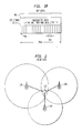
- FIG. 1a depicts a global positioning system (GPS) 10.
- Each satellite 12- j orbits the earth at a known speed ⁇ j and is separated by a known distance from the other satellites 12- j .
- Each satellite 12- j transmits a global position signal 11 -j which includes a carrier signal with a known frequency f modulated with a unique pseudo-random noise (PN- j ) code and navigational data (ND- j ) associated with the particular satellite 12- j .
- the PN- j code includes a unique sequence of PN chips and navigation data ND- j which includes a satellite identifier, timing information and orbital data, such as elevation angle ⁇ j and azimuth angle ⁇ j .
- FIG. 1b depicts a typical 20 ms frame of the GPS signal 11- j which comprises twenty full sequences of a PN- j code in addition to a sequence of navigation data ND- j .
- GPS receiver 14 replicates carrier signals to match the frequencies of the GPS signals 11- j as they arrive at GPS receiver 14.
- the frequency f at which GPS signals 11- j are transmitted changes an unknown amount ⁇ f j before the signal 11- j arrives at the GPS receiver 14.
- each GPS signal 11- j will have a frequency f + ⁇ f j when it arrives at the GPS receiver 14.
- GPS receiver 14 replicates the carrier signals across a frequency spectrum f spec ranging from f + ⁇ f min to f + ⁇ f max until the frequency of the replicated carrier signal matches the frequency of the received GPS signal 11- j , wherein ⁇ f min and ⁇ f max are a minimum and maximum change in the frequency the GPS signals 11- j will undergo due to the Doppler effect as they travel from satellites 12- j to GPS receiver 14, i.e., ⁇ f min ⁇ ⁇ f j ⁇ ⁇ f max .
- GPS receiver 14 replicates the unique PN- j codes associated with each satellite 12- j .
- the phases of the replicated PN- j codes are shifted across code phase spectrums R j (spec) until the replicated carrier signals modulated with the replicated PN- j codes correlate, if at all, with the GPS signals 11- j being received by the GPS receiver 14, where each code phase spectrum R j (spec) includes every possible phase shift for the associated PN- j code.
- GPS receiver 14 extracts the navigation data ND- j from the detected GPS signals 11- j and uses the navigation data ND- j to determine a location for the GPS receiver 14.
- a GPS enables a ground based receiver to determine its position by measuring the time difference required for GPS signals initiated from two or more satellites to be received by the GPS receiver 14.
- the pseudorange is defined as this time difference times the speed of light.
- the pseudorange is not the real range because it contains errors caused by the receiver clock offset.
- To determine a two-dimensional position usually entails receiving signals from at least three satellites.
- To determine a three-dimensional position usually entails requires receiving pseudoranges from four or more satellites. This precondition, however, may not always be satisfied, especially when the direct satellite signals are obstructed, such as when a wireless terminal is inside a building.
- GPS receivers such as GPS receiver 14 are now being incorporated into wireless mobile communication devices (including mobile telephones, PDAs, pagers, portable computers, etc.). However, these devices do not always have a clear view of the sky. In this situation, the signal-to-noise ratios of GPS signals 11- j received by GPS receiver 14 are typically much lower than when GPS receiver 14 does have a clear view of the sky, thus making it more difficult for GPS receiver 14 to detect the GPS signals 11- j .
- Integrated wireless-global positioning (WGP) systems were developed to facilitate the detection of GPS signals by GPS receivers in wireless mobile communication devices.
- the WGP system facilitates detection of GPS signals by reducing the number of integrations to be performed by correlators searching for GPS signals. The number of integrations is reduced by narrowing the frequency range and code phase ranges to be searched.
- the WGP system limits the search for GPS signals to a specific frequency or frequencies and to a range of code phases less than the code phase spectrum R j (spec).
- R j code phase spectrum
- problems of obstructed signals still exist.
- an even greater problem involves the fact that many wireless mobile communication devices do not include any type of GPS receiver. These type of "legacy" devices, therefore, need to be located by some other measure.
- Another known way of determining the position of a wireless mobile communication device is to utilize information obtained from a wireless network.
- One such method of geolocation uses signal strength measurements.
- signal strengths are extensively used for so-called MAHO (mobile-assisted handoff) process.
- the MAHO measurement contains signal strength information, which reflects the distance between the wireless terminal and a base station (BS).
- MAHO measurement lists are routinely delivered by wireless mobile communication devices for handoff purposes and form the basis of a low-accuracy geolocation system based on either, or a combination, of two techniques: "triangulation" and "contour matching".
- Fig. 2 illustrates a known method for determining a location from which a mobile caller originates a call on a wireless mobile 102. Specifically, a signal originating from at least one base station, such as base station 104, reaches the wireless mobile 102 with a particular signal strength at a particular time. Similarly, signals from base stations 106 and 108 send similar signals, which arrive at wireless mobile 102 at the same time but with varying signal strengths.
- the wireless system receives MAHO measurements and compares these relative signal strength measurements to a specifically-developed database of stored positions (grid locations) and relative signal strength measurements within the cell serving the call. The wireless system can then determine the location of the wireless mobile communication device by matching its signal strength measurements to the corresponding signal strength measurements of one of these grid locations in the database.
- An improvement on the grid system was to establish contours between grid points using interpolation and in some cases prediction from simulations or propagation models. Once the database is established, received signals can be matched to the contours, thus the name "contour matching.”
- An alternative to the MAHO technique discussed is the so-called Enhanced Cell Global Identity (ECGI) method.
- ECGI Enhanced Cell Global Identity
- CGI is a standardized technique for geolocation in the Global System for Mobile communications (GSM), and involves enhancing CGI by database matching techniques described previously.
- GSM Global System for Mobile communications
- MAHO Timing Advance
- TA measurements like MAHO measurements, are made at the mobile terminal (wireless mobile communication device) and can determine, albeit with low precision, the location of a wireless mobile communication device.
- TA measurements differ fundamentally from MAHO measurements in that TA is time-based and MAHO is strength-based, but both can be used as indicators of distance, and thus be applied to location finding.
- a database technique can be used to locate wireless mobile communication devices.
- the database technique can use direct (grid based) data matching or a contour matching technique.
- the underlying data populating the database always contains geographic coordinates (e.g., latitude/longitude data), and also may contain either signal strength data (such as MAHO data), TA data, both or other data types. Other data types may be used as well.
- Integrated wireless-global positioning (WGP) systems rely on both the satellite navigation system and the wireless communication system to determine the location of a wireless terminal.
- An integrated wireless-global positioning system combines the data from both the wireless network and the satellite navigation system to obtain an integrated position solution. By combining information from both the global positioning system and the wireless network, it is possible to increase the positioning accuracy and, at the same time, overcome the requirement of having at least three measurements from a single source type.
- WGP wireless-global positioning
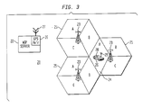
- FIG. 3 depicts an integrated wireless global positioning system 20 comprising a WGP server 22, a plurality of base stations 23 and at least one WGP client 24.
- WGP server 22 includes a GPS receiver 26 having an antenna 27 installed in a known stationary location with a clear view of the sky.
- WGP server 22 is operable to communicate with base stations 23 either via a wired or wireless interface.
- Each base station 23 is at a known location and provides communication services to WGP clients located within a geographical area or cell 25 associated with the base station 23, wherein each cell 25 is a known size and may be divided into a plurality of sectors.
- WGP client 24 includes a GPS receiver 28 and perhaps a wireless terminal such as a wireless telephone 29, and is typically in motion and/or at an unknown location with or without a clear view of the sky.
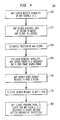
- FIG. 4 is a flowchart 300 illustrating the operation of WGP system 20.
- WGP server 22 detects a plurality of satellites 12- j via their GPS signals 11- j using its GPS receiver 26.
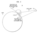
- WGP server 22 acquires the following information from each detected satellite 12- j : the identity of satellite 12- j and frequency f j , code phase, elevation angle ⁇ j and azimuth angle ⁇ j associated with the detected satellite 12- j , wherein the elevation angle ⁇ j is defined as the angle between the line of sight from WGP server 22 or client 24 to a satellite 12- j and a projection of the line of sight on the horizontal plane, and the azimuth angle ⁇ j is defined as the angle between the projection of the line of sight on the horizontal plane and a projection of the north direction on the horizontal plane.
- FIG. 5 depicts an elevation angle ⁇ j and an azimuth angle ⁇ j corresponding to a satellite 12- j and a WGP server 22 or WGP client 24.
- WGP server 22 receives sector information from base station 23 currently in communication with or serving WGP client 24, wherein the sector information indicates the sector WGP client 24 is currently located.
- WGP server 22 makes an initial estimate of WGP client's position based on the known location of the serving base station, the cell size associated with the serving base station, and the sector in which WGP client 24 is currently located. In one embodiment, WGP server 22 initially estimates that WGP client 24 is located at a reference point within the sector, e.g., point at approximate center of sector. In another embodiment, WGP server 22 initially estimates WGP client 24's position using known forward link triangulation techniques.
- step 330 for each detected satellite 12- j , WGP server 22 uses the information acquired from the detected GPS signals 11- j to predict a frequency f j (r) at the reference point and a code phase search range R j (sect) which includes all possible code phases for GPS signal 11- j arriving anywhere within the sector where WGP client 24 is currently located.
- step 340 WGP server 22 transmits a search message to the serving base station 23, where the search message includes, for each detected satellite 12- j , information regarding the associated PN- j code, predicted frequency f j (r) and code phase search range R j (sect).
- serving base station 23 transmits the search message to WGP client 24 which, in step 360, begins a parallel search for the satellites 12- j indicated in the search message.
- WGP client 24 uses its correlators to simultaneously search for each of the GPS signals 11- j at the predicted frequency f j (r) within the limitations of the code phase search range R j (sect) indicated in the search message.
- a system and method of the present application involves calibration or population of a position locating system, with reliable position information (from GPS signals, position signals derived from enhanced based position techniques, etc.). Thereafter, both downlink network information and reliable position information are associated together.
- network downlink information (MAHO data for signal strength/TA data, etc.) is associated with accurate position information to accurately populate a database, and can thereafter be used to determine position based on triangulation, contour matching, etc.
- Such an accurate location system can thereafter be used to locate a wireless mobile communication device, such as in E911 situations, for example.
- the present application involves associating together, both downlink information and reliable position information, to populate and calibrate a position location system.
- the system and method of the present application involve receiving reliable position information (from GPS signals, position signals derived from enhanced based position techniques (EOTD), etc.), at a plurality of locations, by at least one wireless mobile communication device; determining downlink information from signals received by at least one wireless mobile communication device, at each of the plurality of locations; and associating location information, obtained from received global position signals, with downlink information determined at each of the plurality of locations, to thereby calibrate the position location system.
- reliable position information from GPS signals, position signals derived from enhanced based position techniques (EOTD), etc.
- a system is first preferably established to determine when reliable position data, such as GPS data, are received. These data are then assumed to be "ground truth”. Thereafter, downlink information (such as MAHO or TA) from wireless mobile communication devices receiving the reliable GPS data and needed for subsequent contour matching, are associated with the reliable GPS data to populate a position location database. Once the database of associated reliable GPS data and downlink information is established, it can then be used to assist in determining the location of wireless mobile communication devices whose positions are not known and/or cannot easily be determined.
- reliable position data such as GPS data
- downlink information such as MAHO or TA
- EOTD is a mobile-assisted positioning method used by Global System for Mobile (GSM) Communication networks to accurately fix the latitude and longitude of a mobile device. While GPS, because of its accuracy, is the preferred embodiment, the description herein does not preclude the use of other mobile-assisted positioning methods such as EOTD.
- GSM Global System for Mobile
- the position location system is preferably an integrated wireless-global positioning (WGP) system, which can determine the location of a wireless mobile communication device ("mobile”) from associated satellite measurements and wireless network measurements.
- WGP wireless-global positioning
- the accuracy of the location identified for legacy mobiles and mobiles with poor or no GPS reception depends on the quality of a contour matching database, which must be established and maintained. Database quality is important for the success of the WGP system.
- the WGP system is used to automatically build and maintain the required database based upon reliable GPS data. The method does not require that a particular system be set up for the calibration, and it does not require a team of technical experts to perform field calibrations. With this method, the wireless mobile communication devices that have unobstructed reception of GPS signals are assumed to provide "ground truth" (reliable GPS data). Thereafter, network-derived downlink data (such as MAHO signal strength or TA timing information, etc.) can be taken at the same place, and can then be used to populate a contour matching database.
- ground truth reliable GPS data
- a mobile with TDMA capability could make MAHO measurements. If that mobile were equipped with GSM-GPS capability, it could be used to calibrate the TDMA database. Accordingly, based upon received reliable GPS data, different types of mobiles can provide different types of calibration data for subsequent use in locating the position of other mobiles.
- the calibration approach outlined above has the advantage of allowing ordinary calls to be used for calibration, as the class of new mobiles with enhanced geolocation capability are used to automate the process of calibrating the network for future calls, both from newly equipped, and (perhaps more importantly) for legacy mobiles.
- a satellite navigation system such as the global positioning system, typically comprises a constellation of satellites that transmit satellite signals that can be used by a wireless mobile communication device ("wireless mobile") to determine the position of the wireless mobile.
- the position of a wireless mobile on earth is determined by the time differences required for global positioning system (GPS) signals initiated at the various satellites to be received by the wireless mobile.
- GPS global positioning system
- To determine a two dimensional position usually entails receiving signals from at least three satellites.
- To determine a three dimensional position usually entails receiving signals from four or more satellites. This precondition, however, may not always be satisfied, especially when the satellite signals are obstructed and cannot be received directly by a wireless terminal such as when the wireless terminal is in a building.
- the position of a wireless mobile may also be determined by the use of contour matching or similar techniques that use readily available information from a wireless network.
- Contour matching compares a signature (for example, from MAHO data in a TDMA system, Timing Advance (TA) in a GSM system, or generically any "downlink" information, etc.) with a database containing geographic locations and signatures. Populating and maintaining the database is achieved using information from mobiles receiving reliable GPS data as will be explained hereafter.
- FIG. 6 illustrates a plurality of wireless mobile communication devices, also called Mobile Stations (MS). These devices send information to, and receive information from a plurality of base stations (BS).
- BS base stations
- MS wireless mobile communication devices
- MS wireless mobile communication devices
- BS base stations
- FIG. 6 illustrates a plurality of wireless mobile communication devices, also called Mobile Stations (MS). These devices send information to, and receive information from a plurality of base stations (BS).
- BS base stations
- BS base stations
- Some of the wireless mobile communication devices have excellent reception of global positioning system (GPS) signals and wireless network signals, while others may be located where the GPS signals are partially or completely blocked by obstructions. For those wireless mobile communication devices that have excellent GPS reception, there may be no need to use the other parameters of the wireless network for position computation.
- GPS global positioning system
- the accuracy obtained by using the GPS signals received directly from the satellites is usually better than 10 meters for each position fix.
- the downlink information (MAHO/ TA/ etc.) obtained by these wireless mobile communication devices that have excellent GPS reception can be used in autonomous calibration of database parameters 670, through Position Determining Entity (PDE) processor 650, of a database of geolocation parameters 660 as shown in Figure 6.
- PDE Position Determining Entity
- the method recognizes that many mobiles, and many types of mobiles, are served by most practical wireless systems.
- highly accurate mobile location technologies such as Assisted GPS (A-GPS) are deployed, some of the mobiles 610, 620, etc. may be mobiles equipped for this highly accurate method.
- mobiles 610, 620, etc. are so equipped and are located outdoors with a clear view of the sky, they will receive GPS signals clearly and be located accurately.
- A-GPS processes run in a networkbased Position Determining Entity (PDE) 650
- PDE Position Determining Entity
- the location of A-GPS equipped mobiles can be examined periodically for mobiles being located that are reporting signals of high carrier-to-noise ratios from say, 6 or 7 satellites.
- PDE 650 When PDE 650 runs the process of locating mobile 610, 620, etc., it can also record the downlink information (signal strength, timing, etc.); assuming that the criteria for declaring a given location process as having found ground truth has been met.
- Base Stations 640, etc. would normally serve to transfer the necessary signals between the PDE 650 and the mobiles 610, 620, etc., although the PDE 650 may alternately be located within the Base Stations 640.
- the PDE 650 which normally locates the mobiles, is the entity in which the processes for autonomous calibration of database parameters 670 are run.
- the autonomous calibration of database parameters 670 can occur in a separate entity, outside of PDE 650.
- the PDE 650 preferably further includes a memory maintaining a database of geolocation parameters 660, that reflects downlink timing and/or signal strength data associated with grid points of latitude/longitude. These grid points can be associated with geographic cells (small cells for location, not to be confused with cells or cellular communications).
- this database 660 can also be maintained in a separate memory entity, along with or separate from the autonomous calibration 670.
- legacy mobiles can subsequently be located using a controller 665 of PDE 650 performing a look-up process in the database 660 (involving grid point pattern matching or contour matching , for example).
- look-up and matching schemes are discussed in one or more of application U.S application serial number 09/294,997 filed 4/20/99, entitled " A Bayesian-Update Based Location Prediction Method for CDMA Systems" to Kirk Chang et. al; U.S.
- the look-up process is enhanced by forming contours (contour matching) of consistent parameters, instead of grid points.
- the process for locating mobiles via such controller/database processes is the subject of one or more of the U.S. applications mentioned above, and will not be further described for the sake of brevity, except to note that it may involve a process of initially populating the database 660, checking the quality of the resulting data, and updating the data periodically or as needed/indicated by the quality checks. Issues of granularity of the database, speed of look-ups, and even how many parameters to associate with a given grid point (i.e., how many parameters constitute an optimal signature, for example 5 timing and 4 strength measurements) are discussed in the aforementioned U.S. patent applications and will not be further discussed for the sake of brevity.
- lookup process is enhanced by mechanisms which allow a network operator to selectively flush data from selected gridpoints, as would be necessary in the event of a change in network operating parameters in basestations with signals visible from the selected area, or in the event a new basestation is brought online.
- database update techniques may be employed which give greater weight to the most recent position estimates.
- the controller 665 within the PDE 650 can check the mobile type 680 or simply examine the data arriving to see whether a process of A-GPS or of contour matching should be pursued.
- the PDE 650 can advantageously host several geolocation processes 690, reflecting various technologies such as A-GPS, contour matching, and/or others, in a common solution engine. If reliable GPS data is received by the wireless mobile communication device and A-GPS can be used, a position of the mobile is determined based on this data. However, if the mobile has no capability to receive GPS/A-GPS signals or such signals are blocked or otherwise cannot be received, the contour matching process is pursued based upon stored downlink information and that received by the mobile. As such, any mobile can be easily located.
- the appropriate parts of the solution engine are engaged according to data type, and as described above, synergies between technologies, as illustrated above with A-GPS and contour matching, are exploited.
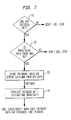
- FIG. 7 is a flowchart illustrating the method for populating a position location system database, or for calibrating the position location system, using signal strength information of wireless mobile communication devices receiving reliable GPS/A-GPS signals.
- step S1 it is first determined whether or not global positioning signals received by a wireless mobile communication device are reliable, based upon signal characteristics of the received global positioning signals (whether or not certain GPS/A-GPS criteria are met); i.e. the suitability of A-GPS data for being declared ground truth is tested.
- the signal characteristics can include carrier to noise ratios, RMS measurement errors, etc. If it is determined that the received GPS/A-GPS signals are not reliable and/or that the specified GPS/A-GPS criteria has not been met, then these signals will not be used. Only signals from wireless mobile communication devices receiving reliable GPS/A-GPS signals are used for populating the database.
- step S2 the downlink timing and/or signal strength measurements are checked to see whether or not enough data are present. The reliability of those data available are also measured, i.e., whether or not the wireless mobile communication device has enough accurate signal strength/timing data corresponding to that GPS confirmed position. If for some reason the wireless mobile communication device did not have such signal strength information at the confirmed GPS position, then the process would again stop. However, assuming that enough accurate data was present, then the method would proceed to step S3.
- step S3 the corresponding downlink or "network" data is then stored in association with the GPS/A-GPS position data. More preferably, positional latitude and longitude information is derived from the GPS/A-GPS data, and the corresponding downlink data is stored in association therewith.
- step S4 the database of the position location system is populated with the downlink information (such as the signal strength/timing, etc.) and associated latitude and longitude information. Accordingly, the derived latitude/longitude data, along with downlink timing and/or signal strength data can be considered an acceptable signature of a grid area, and will be stored in database 660; otherwise, those data are discarded.
- the downlink information such as the signal strength/timing, etc.
- a database is established for a position location system, from which position information can be derived (via "contour matching" of signal strength data, for example) for wireless mobile communication devices that do not receive reliable GPS/A-GPS data (including "legacy" mobiles which have no capabilities to receive any GPS/A-GPS data and/or mobile which do not receive accurate GPS/A-GPS data).
- the calibrated position location system is useable to determine a location of a wireless mobile communication device by correlating its received downlink information (including MAHO/TA/etc.) with stored downlink information (including MAHO/TA/etc.), and by determining a location associated with the stored downlink information. From this populated database 660, contour matching or GPS/A-GPS data can be used to locate the position of any type of mobile.
Applications Claiming Priority (2)
| Application Number | Priority Date | Filing Date | Title |
|---|---|---|---|
| US863438 | 1986-05-15 | ||
| US09/863,438 US6570529B2 (en) | 2001-05-24 | 2001-05-24 | Autonomous calibration of a wireless-global positioning system |
Publications (1)
| Publication Number | Publication Date |
|---|---|
| EP1260829A1 true EP1260829A1 (de) | 2002-11-27 |
Family
ID=25341093
Family Applications (1)
| Application Number | Title | Priority Date | Filing Date |
|---|---|---|---|
| EP01310535A Ceased EP1260829A1 (de) | 2001-05-24 | 2001-12-17 | Autonome Kalibrierung einer drahtlosen globalen Navigationsanlage |
Country Status (3)
| Country | Link |
|---|---|
| US (1) | US6570529B2 (de) |
| EP (1) | EP1260829A1 (de) |
| JP (1) | JP4527930B2 (de) |
Cited By (10)
| Publication number | Priority date | Publication date | Assignee | Title |
|---|---|---|---|---|
| EP1450574A2 (de) | 2003-02-19 | 2004-08-25 | SK Telecom Co., Ltd. | Verfahren und System zur Optimierung ortsabhängiger Dienste durch Anpassen der maximalen Antennenreichweite |
| EP1500947A1 (de) * | 2003-07-22 | 2005-01-26 | Microsoft Corporation | System zur Bestimmung der annähernden Position einer Vorrichtung mittels Umgebungssignalen |
| EP1500948A1 (de) | 2003-07-22 | 2005-01-26 | Microsoft Corporation | Benutzung der ungefähren Position einer von Umgebungssignalen bestimmten Vorrichtung |
| EP1500949A1 (de) | 2003-07-22 | 2005-01-26 | Microsoft Corporation | Verfahren zur Bestimmung der annähernden Position einer Vorrichtung mittels Umgebungssignalen |
| EP1555845A1 (de) * | 2004-01-15 | 2005-07-20 | Siemens Aktiengesellschaft | Verfahren zur Positionsbestimmung von Teilnehmerstationen eines Funkkommunikationssystems |
| WO2006118494A1 (en) * | 2005-04-29 | 2006-11-09 | Telefonaktiebolaget Lm Ericsson (Publ) | Method and arrangements relating to satellite-based positioning |
| EP1865335A1 (de) * | 2006-06-07 | 2007-12-12 | Siemens Aktiengesellschaft | Hybride Lokalisierung in einem Funkkommunikationssystem |
| RU2446415C1 (ru) * | 2011-01-19 | 2012-03-27 | Виктор Михайлович Царев | Способ оценки точности определения координат, обеспечиваемой при помощи аппаратуры, принимающей сигналы глобальных навигационных спутниковых систем |
| CN103549740A (zh) * | 2013-11-15 | 2014-02-05 | 黑龙江大学 | Gps防盗钱包及其防盗定位方法 |
| CN109471134A (zh) * | 2017-09-08 | 2019-03-15 | 网络搜索系统公司 | 地理定位分析系统和运营商网络装备参数的自动校准 |
Families Citing this family (59)
| Publication number | Priority date | Publication date | Assignee | Title |
|---|---|---|---|---|
| FI108372B (fi) | 2000-06-30 | 2002-01-15 | Nokia Corp | Menetelmõ ja laite paikanmõõritykseen |
| US6701153B1 (en) * | 2000-07-28 | 2004-03-02 | Lucent Technologies Inc. | Methods and systems for determining the location of mobiles in a UMTS telecommunications system |
| US7254402B2 (en) * | 2000-10-12 | 2007-08-07 | Qualcomm Incorporated | GPS satellite signal acquisition assistance system and method in a wireless communications network |
| US6826162B2 (en) * | 2001-09-28 | 2004-11-30 | Hewlett-Packard Development Company, L.P. | Locating and mapping wireless network devices via wireless gateways |
| US7383049B2 (en) * | 2001-12-27 | 2008-06-03 | Qualcomm Incorporated | Automation of maintenance and improvement of location service parameters in a data base of a wireless mobile communication system |
| US6950664B2 (en) * | 2002-01-24 | 2005-09-27 | Lucent Technologies Inc. | Geolocation using enhanced timing advance techniques |
| US7363044B2 (en) * | 2002-09-30 | 2008-04-22 | Motorola, Inc. | System and method for aiding a location determination in a positioning system |
| WO2004036924A2 (en) * | 2002-10-16 | 2004-04-29 | Andrew Corporation | Enhancing the accuracy of a location estimate |
| TWI229564B (en) * | 2003-02-19 | 2005-03-11 | Sk Telecom Co Ltd | Test apparatus and control method thereof for use with location based service system capable of optimizing location based service by adjusting maximum antenna range |
| US6993342B2 (en) * | 2003-05-07 | 2006-01-31 | Motorola, Inc. | Buffer occupancy used in uplink scheduling for a communication device |
| US8971913B2 (en) * | 2003-06-27 | 2015-03-03 | Qualcomm Incorporated | Method and apparatus for wireless network hybrid positioning |
| US8483717B2 (en) | 2003-06-27 | 2013-07-09 | Qualcomm Incorporated | Local area network assisted positioning |
| US7123928B2 (en) * | 2003-07-21 | 2006-10-17 | Qualcomm Incorporated | Method and apparatus for creating and using a base station almanac for position determination |
| US7773985B2 (en) | 2003-09-22 | 2010-08-10 | United Parcel Service Of America, Inc. | Symbiotic system for testing electromagnetic signal coverage in areas near transport routes |
| US7660577B2 (en) * | 2003-09-22 | 2010-02-09 | United Parcel Service Of America, Inc. | Network testing systems and methods |
| DE10345511B4 (de) * | 2003-09-30 | 2005-11-17 | Siemens Ag | Verfahren zur Ermittlung der Ortsposition mindestens eines mobilen Funkkommunikationsgeräts, zugehöriges Funkkommunikationsgerät sowie Funkkommunikationssystem |
| US20050143090A1 (en) * | 2003-12-29 | 2005-06-30 | Interdigital Technology Corporation | Location aided wireless signal characteristic adjustment |
| US9137771B2 (en) | 2004-04-02 | 2015-09-15 | Qualcomm Incorporated | Methods and apparatuses for beacon assisted position determination systems |
| US20050227689A1 (en) * | 2004-04-13 | 2005-10-13 | Jewett David T | Method and apparatus for automatic calibration of positioning system base stations |
| US7209077B2 (en) * | 2004-06-29 | 2007-04-24 | Andrew Corporation | Global positioning system signal acquisition assistance |
| EP1783929A4 (de) * | 2004-08-26 | 2012-03-21 | Vodafone Plc | Korrekturverfahren für referenzpositionsinformationen, serversystem und korrektursystem für referenzpositionsinformationen |
| US7920544B2 (en) | 2005-03-28 | 2011-04-05 | Qualcomm Incorporated | Method and apparatus for enhancing signal-to-noise ratio of position location measurements |
| US8054924B2 (en) * | 2005-05-17 | 2011-11-08 | General Motors Llc | Data transmission method with phase shift error correction |
| CA2558341C (en) * | 2005-09-01 | 2016-04-19 | Radio Ip Software Inc. | Gps data management module for use in location-based service systems |
| US8194526B2 (en) * | 2005-10-24 | 2012-06-05 | General Motors Llc | Method for data communication via a voice channel of a wireless communication network |
| US8194779B2 (en) * | 2005-10-24 | 2012-06-05 | General Motors Llc | Method for data communication via a voice channel of a wireless communication network |
| US8259840B2 (en) | 2005-10-24 | 2012-09-04 | General Motors Llc | Data communication via a voice channel of a wireless communication network using discontinuities |
| US7705775B2 (en) * | 2005-12-30 | 2010-04-27 | General Motors Llc | Method of improving a vehicle emergency call network |
| US20070190950A1 (en) * | 2006-02-15 | 2007-08-16 | General Motors Corporation | Method of configuring voice and data communication over a voice channel |
| US7554440B2 (en) * | 2006-07-25 | 2009-06-30 | United Parcel Service Of America, Inc. | Systems and methods for monitoring travel conditions |
| US7974633B2 (en) * | 2006-08-18 | 2011-07-05 | Andrew, Llc | System and method for single sensor geolocation |
| US7899006B2 (en) | 2006-12-05 | 2011-03-01 | Zebra Enterprise Solutions Corp. | Location system for wireless local area network (WLAN) using RSSI and time difference of arrival (TDOA) processing |
| US9048784B2 (en) | 2007-04-03 | 2015-06-02 | General Motors Llc | Method for data communication via a voice channel of a wireless communication network using continuous signal modulation |
| US7912149B2 (en) * | 2007-05-03 | 2011-03-22 | General Motors Llc | Synchronization and segment type detection method for data transmission via an audio communication system |
| TWI345068B (en) * | 2007-07-20 | 2011-07-11 | Mitac Int Corp | Method, device and system for high-speed positioning |
| US20090191897A1 (en) * | 2008-01-24 | 2009-07-30 | Cortxt, Inc. | Environment Characterization for Mobile Devices |
| US8213955B2 (en) * | 2008-05-01 | 2012-07-03 | Andrew, Llc | Network measurement report caching for location of mobile devices |
| US11482058B2 (en) | 2008-09-09 | 2022-10-25 | United Parcel Service Of America, Inc. | Systems and methods for utilizing telematics data to improve fleet management operations |
| CA2736168C (en) | 2008-09-09 | 2018-04-10 | United Parcel Service Of America, Inc. | Systems and methods of utilizing telematics data to improve fleet management operations |
| US8478228B2 (en) | 2008-10-20 | 2013-07-02 | Qualcomm Incorporated | Mobile receiver with location services capability |
| TWI394976B (zh) * | 2008-12-24 | 2013-05-01 | Mstar Semiconductor Inc | 定位輔助方法以及使用該方法之定位輔助裝置 |
| US8600297B2 (en) | 2009-07-28 | 2013-12-03 | Qualcomm Incorporated | Method and system for femto cell self-timing and self-locating |
| US8873524B2 (en) | 2009-10-27 | 2014-10-28 | At&T Intellectual Property I, L.P. | Method and apparatus for providing channel sharing among white space networks |
| US8416134B2 (en) * | 2009-12-01 | 2013-04-09 | At&T Mobility Ii Llc | Systems and methods for providing geolocation using wireless signals |
| CN101915933A (zh) * | 2010-08-17 | 2010-12-15 | 中兴通讯股份有限公司 | 辅助全球卫星定位系统定位的方法及装置 |
| FR2966627B1 (fr) * | 2010-10-26 | 2012-12-21 | Somfy Sas | Procede de fonctionnement d'une unite mobile de commande d'une installation domotique. |
| US8543688B1 (en) | 2010-12-08 | 2013-09-24 | Sprint Communications Company L.P. | Generating correlation codes for location information |
| US9953468B2 (en) | 2011-03-31 | 2018-04-24 | United Parcel Service Of America, Inc. | Segmenting operational data |
| US9208626B2 (en) | 2011-03-31 | 2015-12-08 | United Parcel Service Of America, Inc. | Systems and methods for segmenting operational data |
| CN102271397A (zh) * | 2011-09-09 | 2011-12-07 | 上海聚美物联网科技有限公司 | 基于wifi网络的定位系统与方法 |
| US9188668B2 (en) | 2012-11-27 | 2015-11-17 | At&T Intellectual Property I, L.P. | Electromagnetic reflection profiles |
| US9805521B1 (en) | 2013-12-03 | 2017-10-31 | United Parcel Service Of America, Inc. | Systems and methods for assessing turns made by a vehicle |
| CN105182389A (zh) * | 2014-03-26 | 2015-12-23 | 马维尔国际有限公司 | 利用用户设备收集定位数据的方法和用户设备 |
| US10309788B2 (en) | 2015-05-11 | 2019-06-04 | United Parcel Service Of America, Inc. | Determining street segment headings |
| CN105022030A (zh) * | 2015-07-06 | 2015-11-04 | 苏州金立方通讯科技有限公司 | 一种无线定位系统 |
| CN105652242B (zh) * | 2016-03-29 | 2018-07-06 | 天津工业大学 | 基于ZigBee技术的室内定位系统 |
| CN106228847B (zh) * | 2016-09-28 | 2019-06-28 | 深圳市豪位科技有限公司 | 一种停车场车辆导航系统及导航方法 |
| DE102018209258A1 (de) * | 2018-06-11 | 2019-12-12 | Bayerische Motoren Werke Aktiengesellschaft | Verfahren und anordnung zum bestimmen eines aufenthalsbereichs einer funkvorrichtung, und fahrzeug mit einer solchen anordnung |
| CN109084793B (zh) * | 2018-07-27 | 2020-09-01 | 北京航空航天大学 | 一种基于北斗的网格增强自动驾驶多级告警方法 |
Citations (7)
| Publication number | Priority date | Publication date | Assignee | Title |
|---|---|---|---|---|
| EP0631453A2 (de) * | 1993-06-21 | 1994-12-28 | Telia Ab | Verfahren zur Aufenthaltsortbestimmung von mobil Stationen in einem digitalen Telefonnetzwerk |
| WO1998010538A1 (en) * | 1996-09-09 | 1998-03-12 | Leblanc Frederick W | Location of a mobile station using a plurality of commercial wireless infrastructures |
| US5948043A (en) * | 1996-11-08 | 1999-09-07 | Etak, Inc. | Navigation system using GPS data |
| US5982324A (en) * | 1998-05-14 | 1999-11-09 | Nortel Networks Corporation | Combining GPS with TOA/TDOA of cellular signals to locate terminal |
| US6002936A (en) * | 1998-03-09 | 1999-12-14 | Ericsson Inc. | System and method for informing network of terminal-based positioning method capabilities |
| US6026304A (en) * | 1997-01-08 | 2000-02-15 | U.S. Wireless Corporation | Radio transmitter location finding for wireless communication network services and management |
| WO2001028272A1 (en) * | 1999-10-13 | 2001-04-19 | Koninklijke Kpn N.V. | Method and system for finding the position of mobile terminals |
Family Cites Families (10)
| Publication number | Priority date | Publication date | Assignee | Title |
|---|---|---|---|---|
| US4463357A (en) * | 1981-11-17 | 1984-07-31 | The United States Of America As Represented By The Administrator Of The National Aeronautics And Space Administration | Method and apparatus for calibrating the ionosphere and application to surveillance of geophysical events |
| US4965586A (en) * | 1984-08-16 | 1990-10-23 | Geostar Corporation | Position determination and message transfer system employing satellites and stored terrain map |
| US5365447A (en) * | 1991-09-20 | 1994-11-15 | Dennis Arthur R | GPS and satelite navigation system |
| US6353406B1 (en) * | 1996-10-17 | 2002-03-05 | R.F. Technologies, Inc. | Dual mode tracking system |
| CA2283904C (en) * | 1997-03-21 | 2007-01-09 | The Board Of Trustees Of The Leland Stanford Junior University | A system using leo satellites for centimeter-level navigation |
| US6256483B1 (en) * | 1998-10-28 | 2001-07-03 | Tachyon, Inc. | Method and apparatus for calibration of a wireless transmitter |
| EP1058855A4 (de) * | 1998-12-04 | 2004-09-01 | Trafficmaster Usa Inc | Funkstanortsbestimmung mittels räumlicher signaturinformation |
| JP2000244967A (ja) * | 1999-02-24 | 2000-09-08 | Mitsubishi Electric Corp | 移動体通信システム、該システムを構成する移動機および基地局、並びに該システムにおける移動機の位置検出方法 |
| US6369754B1 (en) * | 1999-04-02 | 2002-04-09 | Qualcomm Inc. | Fine positioning of a user terminal in a satellite communication system |
| WO2001084862A2 (en) * | 2000-05-03 | 2001-11-08 | Telefonaktiebolaget Lm Ericsson (Publ) | Calibration of positioning systems |
-
2001
- 2001-05-24 US US09/863,438 patent/US6570529B2/en not_active Expired - Lifetime
- 2001-12-17 EP EP01310535A patent/EP1260829A1/de not_active Ceased
-
2002
- 2002-05-22 JP JP2002147973A patent/JP4527930B2/ja not_active Expired - Fee Related
Patent Citations (7)
| Publication number | Priority date | Publication date | Assignee | Title |
|---|---|---|---|---|
| EP0631453A2 (de) * | 1993-06-21 | 1994-12-28 | Telia Ab | Verfahren zur Aufenthaltsortbestimmung von mobil Stationen in einem digitalen Telefonnetzwerk |
| WO1998010538A1 (en) * | 1996-09-09 | 1998-03-12 | Leblanc Frederick W | Location of a mobile station using a plurality of commercial wireless infrastructures |
| US5948043A (en) * | 1996-11-08 | 1999-09-07 | Etak, Inc. | Navigation system using GPS data |
| US6026304A (en) * | 1997-01-08 | 2000-02-15 | U.S. Wireless Corporation | Radio transmitter location finding for wireless communication network services and management |
| US6002936A (en) * | 1998-03-09 | 1999-12-14 | Ericsson Inc. | System and method for informing network of terminal-based positioning method capabilities |
| US5982324A (en) * | 1998-05-14 | 1999-11-09 | Nortel Networks Corporation | Combining GPS with TOA/TDOA of cellular signals to locate terminal |
| WO2001028272A1 (en) * | 1999-10-13 | 2001-04-19 | Koninklijke Kpn N.V. | Method and system for finding the position of mobile terminals |
Cited By (20)
| Publication number | Priority date | Publication date | Assignee | Title |
|---|---|---|---|---|
| EP1450574A2 (de) | 2003-02-19 | 2004-08-25 | SK Telecom Co., Ltd. | Verfahren und System zur Optimierung ortsabhängiger Dienste durch Anpassen der maximalen Antennenreichweite |
| EP1450574A3 (de) * | 2003-02-19 | 2007-12-19 | SK Telecom Co., Ltd. | Verfahren und System zur Optimierung ortsabhängiger Dienste durch Anpassen der maximalen Antennenreichweite |
| CN1607400B (zh) * | 2003-07-22 | 2010-10-13 | 微软公司 | 根据周围信号确定装置的近似位置的方法 |
| EP1500947A1 (de) * | 2003-07-22 | 2005-01-26 | Microsoft Corporation | System zur Bestimmung der annähernden Position einer Vorrichtung mittels Umgebungssignalen |
| EP1500948A1 (de) | 2003-07-22 | 2005-01-26 | Microsoft Corporation | Benutzung der ungefähren Position einer von Umgebungssignalen bestimmten Vorrichtung |
| EP1500949A1 (de) | 2003-07-22 | 2005-01-26 | Microsoft Corporation | Verfahren zur Bestimmung der annähernden Position einer Vorrichtung mittels Umgebungssignalen |
| US7202816B2 (en) | 2003-07-22 | 2007-04-10 | Microsoft Corporation | Utilization of the approximate location of a device determined from ambient signals |
| KR101099204B1 (ko) | 2003-07-22 | 2011-12-27 | 마이크로소프트 코포레이션 | 주변 신호들로부터 장치의 근사 위치를 결정하는 시스템 |
| US7319877B2 (en) | 2003-07-22 | 2008-01-15 | Microsoft Corporation | Methods for determining the approximate location of a device from ambient signals |
| CN1607399B (zh) * | 2003-07-22 | 2011-08-17 | 微软公司 | 由环境信号确定的设备的近似位置的使用 |
| US7738881B2 (en) | 2003-07-22 | 2010-06-15 | Microsoft Corporation | Systems for determining the approximate location of a device from ambient signals |
| EP1555845A1 (de) * | 2004-01-15 | 2005-07-20 | Siemens Aktiengesellschaft | Verfahren zur Positionsbestimmung von Teilnehmerstationen eines Funkkommunikationssystems |
| WO2006118494A1 (en) * | 2005-04-29 | 2006-11-09 | Telefonaktiebolaget Lm Ericsson (Publ) | Method and arrangements relating to satellite-based positioning |
| CN101213855B (zh) * | 2005-04-29 | 2011-05-04 | 艾利森电话股份有限公司 | 与基于卫星的定位有关的方法和装置 |
| US7692582B2 (en) | 2005-04-29 | 2010-04-06 | Telefonaktiebolaget L M Ericsson (Publ) | Method and arrangements relating to satellite-based positioning |
| EP1865335A1 (de) * | 2006-06-07 | 2007-12-12 | Siemens Aktiengesellschaft | Hybride Lokalisierung in einem Funkkommunikationssystem |
| RU2446415C1 (ru) * | 2011-01-19 | 2012-03-27 | Виктор Михайлович Царев | Способ оценки точности определения координат, обеспечиваемой при помощи аппаратуры, принимающей сигналы глобальных навигационных спутниковых систем |
| CN103549740A (zh) * | 2013-11-15 | 2014-02-05 | 黑龙江大学 | Gps防盗钱包及其防盗定位方法 |
| CN109471134A (zh) * | 2017-09-08 | 2019-03-15 | 网络搜索系统公司 | 地理定位分析系统和运营商网络装备参数的自动校准 |
| CN109471134B (zh) * | 2017-09-08 | 2023-09-29 | 网络搜索系统公司 | 地理定位分析系统和运营商网络装备参数的自动校准 |
Also Published As
| Publication number | Publication date |
|---|---|
| US20020175855A1 (en) | 2002-11-28 |
| JP2003087849A (ja) | 2003-03-20 |
| US6570529B2 (en) | 2003-05-27 |
| JP4527930B2 (ja) | 2010-08-18 |
Similar Documents
| Publication | Publication Date | Title |
|---|---|---|
| US6570529B2 (en) | Autonomous calibration of a wireless-global positioning system | |
| RU2365933C2 (ru) | Система и способ получения данных для помощи в обнаружении сигнала | |
| EP3293539B1 (de) | Verwendung von mobilstationen zur bestimmung von basisstationstandortparametern in einem drahtlosen mobilen kommunikationssystem | |
| JP5518914B2 (ja) | 無線位置決定精度を改善するための方法及び装置 | |
| KR100829666B1 (ko) | 혼성 위치 결정 시스템내에서 에러 추정치를 결정하는방법 및 장치 | |
| US7440762B2 (en) | TDOA/GPS hybrid wireless location system | |
| US7383049B2 (en) | Automation of maintenance and improvement of location service parameters in a data base of a wireless mobile communication system | |
| KR100684541B1 (ko) | Gps 지상 하이브리드 위치 시스템 방정식에 대한대수적 해답을 결정하는 방법 및 장치 | |
| US20100093377A1 (en) | Creating And Using Base Station Almanac Information In A Wireless Communication System Having A Position Location Capability | |
| US20050288033A1 (en) | System and method for location determination | |
| EP1148344A1 (de) | Positionsbestimmung eines drahtlosen Terminals mit Satelliten-Positionierungssignalen oder Bassistationssignalen | |
| KR20000062203A (ko) | 로컬 위치 결정 시스템 | |
| KR20030070920A (ko) | 이동국 위치 픽스를 유효화하는 방법 및 시스템 | |
| WO2003058986A2 (en) | Creating and using base station almanac information in a wireless communication system having a position location capability | |
| JP2002006027A (ja) | 無線網グローバルポジショニング一体化(wgp)システムの無線端末に対する往復遅延時間(rtd)パラメータを得るための方法。 |
Legal Events
| Date | Code | Title | Description |
|---|---|---|---|
| PUAI | Public reference made under article 153(3) epc to a published international application that has entered the european phase |
Free format text: ORIGINAL CODE: 0009012 |
|
| 17P | Request for examination filed |
Effective date: 20020103 |
|
| AK | Designated contracting states |
Kind code of ref document: A1 Designated state(s): AT BE CH CY DE DK ES FI FR GB GR IE IT LI LU MC NL PT SE TR |
|
| AX | Request for extension of the european patent |
Free format text: AL;LT;LV;MK;RO;SI |
|
| 17Q | First examination report despatched |
Effective date: 20030513 |
|
| AKX | Designation fees paid |
Designated state(s): DE FR GB IT SE |
|
| APBN | Date of receipt of notice of appeal recorded |
Free format text: ORIGINAL CODE: EPIDOSNNOA2E |
|
| APBR | Date of receipt of statement of grounds of appeal recorded |
Free format text: ORIGINAL CODE: EPIDOSNNOA3E |
|
| APAA | Appeal reference recorded |
Free format text: ORIGINAL CODE: EPIDOS REFN |
|
| APAF | Appeal reference modified |
Free format text: ORIGINAL CODE: EPIDOSCREFNE |
|
| APAF | Appeal reference modified |
Free format text: ORIGINAL CODE: EPIDOSCREFNE |
|
| APBT | Appeal procedure closed |
Free format text: ORIGINAL CODE: EPIDOSNNOA9E |
|
| STAA | Information on the status of an ep patent application or granted ep patent |
Free format text: STATUS: THE APPLICATION HAS BEEN REFUSED |
|
| 18R | Application refused |
Effective date: 20071224 |