EP1203966A2 - Position determination - Google Patents
Position determination Download PDFInfo
- Publication number
- EP1203966A2 EP1203966A2 EP01308596A EP01308596A EP1203966A2 EP 1203966 A2 EP1203966 A2 EP 1203966A2 EP 01308596 A EP01308596 A EP 01308596A EP 01308596 A EP01308596 A EP 01308596A EP 1203966 A2 EP1203966 A2 EP 1203966A2
- Authority
- EP
- European Patent Office
- Prior art keywords
- receiver
- gps
- positioning system
- positional information
- route
- Prior art date
- Legal status (The legal status is an assumption and is not a legal conclusion. Google has not performed a legal analysis and makes no representation as to the accuracy of the status listed.)
- Withdrawn
Links
- 238000000034 method Methods 0.000 claims description 11
- 238000010586 diagram Methods 0.000 description 5
- 238000004891 communication Methods 0.000 description 2
- 238000005516 engineering process Methods 0.000 description 1
- 238000005259 measurement Methods 0.000 description 1
Images


Classifications
-
- G—PHYSICS
- G01—MEASURING; TESTING
- G01S—RADIO DIRECTION-FINDING; RADIO NAVIGATION; DETERMINING DISTANCE OR VELOCITY BY USE OF RADIO WAVES; LOCATING OR PRESENCE-DETECTING BY USE OF THE REFLECTION OR RERADIATION OF RADIO WAVES; ANALOGOUS ARRANGEMENTS USING OTHER WAVES
- G01S19/00—Satellite radio beacon positioning systems; Determining position, velocity or attitude using signals transmitted by such systems
- G01S19/38—Determining a navigation solution using signals transmitted by a satellite radio beacon positioning system
- G01S19/39—Determining a navigation solution using signals transmitted by a satellite radio beacon positioning system the satellite radio beacon positioning system transmitting time-stamped messages, e.g. GPS [Global Positioning System], GLONASS [Global Orbiting Navigation Satellite System] or GALILEO
- G01S19/42—Determining position
- G01S19/48—Determining position by combining or switching between position solutions derived from the satellite radio beacon positioning system and position solutions derived from a further system
- G01S19/49—Determining position by combining or switching between position solutions derived from the satellite radio beacon positioning system and position solutions derived from a further system whereby the further system is an inertial position system, e.g. loosely-coupled
Definitions
- the present invention relates to position determination, particularly but not exclusively to a method and device for permitting a user to find a location which is not within the coverage of the Global Positioning System (GPS).
- GPS Global Positioning System
- GPS Global Positioning System
- GPS receivers for example the commercially available GarminTM range of GPS receivers.
- GPS is especially suitable for use in wide open areas, but, due to the nature of satellite communications, its availability is limited in highly built-up areas and underground, for example in an underground car park.
- other techniques are used to interpolate during the periods when the user is out of range of the GPS system. Such interpolation is performed by systems which are commonly referred to as dead reckoning systems, which involve estimating the current location by tracking movements from the last known GPS position, using sensors such as gyros, accelerometers, compasses and so on.
- FIG. 1 illustrates a conventional interpolation system.
- a vehicle 1 equipped with a GPS receiver 2 and a dead reckoning system 3 travels between areas with GPS coverage 4, 5 through an area without GPS coverage 6.
- the position 7 of the vehicle 1 just before it enters the area without GPS coverage 6 is known from GPS data.
- the dead reckoning system 3 estimates the position of the vehicle 1 based on its initial position 7 and its subsequent movements, using direction and speed detectors.
- the GPS receiver 2 On re-entry into an area with GPS coverage 5, the GPS receiver 2 once again takes over to provide accurate positional data 8.
- a vehicle position detector which uses a combination of GPS receiver and dead reckoner is described in US Patent No. 5,257,195.
- the present invention aims to address this problem.
- a method of providing positional information to a receiver which is arranged to receive a positioning system signal, the signal providing information relating to the receiver's current position, comprising the steps of tracking the receiver's route from a first position at which the positioning system signal is not available to a second position at which the positioning system signal is available, determining positional information defining the first position from the positioning system signal at the second position and the receiver's route between the first and second positions, and storing the positional information at the receiver.
- the positional information defining the first position can be determined by back tracking from the second position along the route taken by the receiver between the first and second positions.
- a positioning system signal for example a GPS signal
- the user can be provided with information relating to his starting position once he has reached the position at which the GPS signal is available. This enables the user to return to his starting position from any other known position.
- a device for providing positional information to a user the device being arranged to receive a positioning system signal, the signal providing information relating to the current position of the device, comprising means for tracking the route of the device from a first position at which the positioning system signal is not available to a second position at which the positioning system signal is available, means for determining positional information defining the first position from the positioning system signal at the second position and the receiver's route between the first and second positions, and means for storing the positional information.
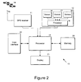
- a locating device 10 includes a GPS receiver 11, a dead reckoning system 12 and a processor 13.
- the GPS receiver 11 receives GPS signals from a GPS satellite constellation 14, via an antenna 15, in a manner which is well-known per se.
- the GPS receiver 11 calculates the positional information from the GPS signals and feeds this information to the processor 13.
- the dead reckoning system 12 comprises a plurality of sensors 16, 17, 18 feeding a local processor 19.
- the sensors 16, 17, 18 comprise devices such as accelerometers, odometers, gyroscopes and other conventional types of inertial navigation system. Reference is directed to Modern Inertial Navigation Technology and its Application, Electronics & Communication Engineering Journal April 2000, pages 49 to 64, for a detailed description of various types of inertial navigation system devices.
- the locating device 10 also includes memory 20, a display 21 and a user interface 22.
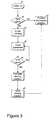
- step s1 when a user switches on the locating device 10 (step s1), the device searches for a GPS signal (step s2). If a GPS signal is found, then the device processes that signal and displays the user's position in an entirely conventional manner (step s3).
- the device marks the user's current position as the starting position for tracking and initiates tracking (step s4).
- the device 10 only initiates tracking on receiving instructions from the user, for example by the user entering an appropriate command at the user interface 22. Tracking is initiated by enabling the dead reckoning system 12.
- any movements made by the user away from the marked starting position are tracked by the dead reckoning system 12.
- an appropriate combination of inertial navigation devices tracks the distance and direction travelled by the user away from the starting location.
- the distance by which the user ascends or descends from the starting level is also determined (step s5).
- the processor 13 checks for the availability of a GPS signal (step s6). Tracking continues while a GPS signal is not available (step s5).
- step s6 determines that a GPS signal has become available (step s6)
- step s7 the input from the dead reckoning system is stopped and the starting position is calculated based on the current GPS position information and the dead reckoning information (step s7), as will be described in more detail below.
- step s8 the starting position is stored in the memory 20 (step s8) and the location device 10 resumes its normal position indicating operation (step s3).
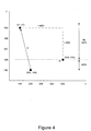
- step s7 The process of calculating the starting position from the GPS position and dead reckoning information (step s7) will now be described by reference to Figure 4.
- Figure 4 shows a user U starting from an unknown starting position (x1, y1) in a region where there is no GPS coverage.
- the locating device 10 tracks his movements by means of a dead reckoning system 12 (step s5).
- the starting position is therefore calculated (step s7) as (100, 500). While the mechanism for calculating starting position has been illustrated for a simple case in two dimensions, it will be appreciated by the skilled person that the starting position can be calculated for any complexity of route in a three dimensional co-ordinate system, as long as accurate values for the distances and directions taken by the user from the starting location to the GPS contact location are maintained.
- the user can return to that position from any other known position by recalling the stored position on his location device 10 (step s10).
- the device 10 determines its current position from current GPS data (step s11), calculates a route to the starting position (step s12) and gives directions to the user to return to the starting position (step s13).
- step s11 determines its current position from current GPS data
- step s12 calculates a route to the starting position
- step s13 For example, referring again to Figure 4, from a new starting position at co-ordinates (200, 100), the user is given a direct route R which results in him returning to the stored starting position.
- GPS signals can be used to update the route while the user remains in the GPS region (step s14).
- the dead reckoning system can be used to keep the user appraised of his position relative to the starting position.
Landscapes
- Engineering & Computer Science (AREA)
- Radar, Positioning & Navigation (AREA)
- Remote Sensing (AREA)
- Computer Networks & Wireless Communication (AREA)
- Physics & Mathematics (AREA)
- General Physics & Mathematics (AREA)
- Navigation (AREA)
- Position Fixing By Use Of Radio Waves (AREA)
Abstract
Description
Claims (10)
- A method of providing positional information to a receiver which is arranged to receive a positioning system signal, the signal providing information relating to the receiver's current position, comprising the steps of:tracking the receiver's route from a first position at which the positioning system signal is not available to a second position at which the positioning system signal is available;determining positional information defining the first position from the positioning system signal at the second position and the receiver's route between the first and second positions; andstoring the positional information at the receiver.
- A method according to claim 1, including determining the positional information defining the first position by back-tracking from the second position along the route taken by the receiver between the first and second positions.
- A method according to claim 1 or 2, including using dead reckoning to track the receiver's route between the first and second positions.
- A method according to any one of the preceding claims, comprising recalling the stored positional information from the receiver to define the first position relative to a known third position.
- A method according to any one of the preceding claims, wherein the positioning system comprises the Global Positioning System (GPS).
- A device for providing positional information to a user, the device being arranged to receive a positioning system signal, the signal providing information relating to the current position of the device, comprising:means for tracking the route of the device from a first position at which the positioning system signal is not available to a second position at which the positioning system signal is available;means for determining positional information defining the first position from the positioning system signal at the second position and the receiver's route between the first and second positions; andmeans for storing the positional information.
- A device according to claim 6, wherein the determining means comprise means for back-tracking from the second position along the route taken by the device between the first and second positions.
- A device according to claim 6 or 7, wherein the tracking means comprises a dead reckoning system.
- A device according to any one of claims 6 to 8, wherein the device uses the stored positional information to define the first position relative to a known third position.
- A device according to any one of claims 6 to 9, comprising a Global Positioning System (GPS) receiver.
Applications Claiming Priority (2)
| Application Number | Priority Date | Filing Date | Title |
|---|---|---|---|
| US2671300P | 2000-11-01 | 2000-11-01 | |
| US26713 | 2000-11-01 |
Publications (2)
| Publication Number | Publication Date |
|---|---|
| EP1203966A2 true EP1203966A2 (en) | 2002-05-08 |
| EP1203966A3 EP1203966A3 (en) | 2003-01-29 |
Family
ID=21833395
Family Applications (1)
| Application Number | Title | Priority Date | Filing Date |
|---|---|---|---|
| EP01308596A Withdrawn EP1203966A3 (en) | 2000-11-01 | 2001-10-09 | Position determination |
Country Status (1)
| Country | Link |
|---|---|
| EP (1) | EP1203966A3 (en) |
Cited By (9)
| Publication number | Priority date | Publication date | Assignee | Title |
|---|---|---|---|---|
| EP1884753A1 (en) * | 2006-08-04 | 2008-02-06 | Seiko Epson Corporation | Electronic device and time adjustment method |
| WO2011153370A3 (en) * | 2010-06-02 | 2013-04-04 | Qualcomm Incorporated | Position determination using measurements from past and present epochs |
| EP2360490A3 (en) * | 2010-01-26 | 2013-07-24 | Hewlett-Packard Development Company, L.P. | Using relative position data in a mobile device |
| US9074897B2 (en) | 2009-06-15 | 2015-07-07 | Qualcomm Incorporated | Real-time data with post-processing |
| US20160054438A1 (en) * | 2014-08-25 | 2016-02-25 | Texas Instruments Incorporated | Vibration parameters monitoring using fmcw radar |
| US9354321B2 (en) | 2006-03-06 | 2016-05-31 | Qualcomm Incorporated | Method for position determination with measurement stitching |
| WO2018104584A1 (en) * | 2016-12-07 | 2018-06-14 | Pehutec Oy | Apparatus, method and computer program improving emergency communication |
| CN110136200A (en) * | 2014-04-25 | 2019-08-16 | 谷歌技术控股有限责任公司 | Electronic equipment positioning based on image |
| CN113155120A (en) * | 2021-03-10 | 2021-07-23 | 中石化管道技术服务有限公司 | Underwater pipeline position coordinate measuring method |
Family Cites Families (5)
| Publication number | Priority date | Publication date | Assignee | Title |
|---|---|---|---|---|
| KR940009235B1 (en) * | 1990-09-12 | 1994-10-01 | 미쯔비시 덴끼 가부시끼가이샤 | On-board vehicle position detector |
| US5644317A (en) * | 1995-03-27 | 1997-07-01 | Motorola, Inc. | Dual positioning location system |
| US5745868A (en) * | 1995-12-26 | 1998-04-28 | Motorola, Inc. | Method for rapid recovery from dead reckoning system heading loss |
| US5890090A (en) * | 1996-11-20 | 1999-03-30 | Trimble Navigation Limited | Half-dead-reckoning capable GPS navigation receiver |
| US6091359A (en) * | 1997-07-14 | 2000-07-18 | Motorola, Inc. | Portable dead reckoning system for extending GPS coverage |
-
2001
- 2001-10-09 EP EP01308596A patent/EP1203966A3/en not_active Withdrawn
Cited By (20)
| Publication number | Priority date | Publication date | Assignee | Title |
|---|---|---|---|---|
| US9354321B2 (en) | 2006-03-06 | 2016-05-31 | Qualcomm Incorporated | Method for position determination with measurement stitching |
| US7616153B2 (en) | 2006-08-04 | 2009-11-10 | Seiko Epson Corporation | Electronic device and time adjustment method |
| EP1884753A1 (en) * | 2006-08-04 | 2008-02-06 | Seiko Epson Corporation | Electronic device and time adjustment method |
| US9074897B2 (en) | 2009-06-15 | 2015-07-07 | Qualcomm Incorporated | Real-time data with post-processing |
| EP2360490A3 (en) * | 2010-01-26 | 2013-07-24 | Hewlett-Packard Development Company, L.P. | Using relative position data in a mobile device |
| CN106707315A (en) * | 2010-06-02 | 2017-05-24 | 高通股份有限公司 | Position determination using measurements from past and present epochs |
| US10247828B2 (en) * | 2010-06-02 | 2019-04-02 | Qualcomm Incorporated | Position determination using measurements from past and present epochs |
| US8704707B2 (en) | 2010-06-02 | 2014-04-22 | Qualcomm Incorporated | Position determination using measurements from past and present epochs |
| CN106707315B (en) * | 2010-06-02 | 2020-12-25 | 高通股份有限公司 | Position determination using measurements from past and current epochs |
| CN103180754A (en) * | 2010-06-02 | 2013-06-26 | 高通股份有限公司 | Position determination using measurements from past and current epochs |
| WO2011153370A3 (en) * | 2010-06-02 | 2013-04-04 | Qualcomm Incorporated | Position determination using measurements from past and present epochs |
| EP2988147B1 (en) * | 2010-06-02 | 2020-02-26 | Qualcomm Incorporated | Position determination using measurements from past and present epochs |
| KR101499366B1 (en) * | 2010-06-02 | 2015-03-05 | 퀄컴 인코포레이티드 | A method, apparatus and computer-readable medium for position determination using measurements from past and present epochs |
| CN110136200A (en) * | 2014-04-25 | 2019-08-16 | 谷歌技术控股有限责任公司 | Electronic equipment positioning based on image |
| EP3624063A1 (en) * | 2014-04-25 | 2020-03-18 | Google Technology Holdings LLC | Electronic device localization based on imagery |
| US11195049B2 (en) | 2014-04-25 | 2021-12-07 | Google Llc | Electronic device localization based on imagery |
| US10809365B2 (en) * | 2014-08-25 | 2020-10-20 | Texas Instruments Incorporated | Vibration parameters monitoring using FMCW radar |
| US20160054438A1 (en) * | 2014-08-25 | 2016-02-25 | Texas Instruments Incorporated | Vibration parameters monitoring using fmcw radar |
| WO2018104584A1 (en) * | 2016-12-07 | 2018-06-14 | Pehutec Oy | Apparatus, method and computer program improving emergency communication |
| CN113155120A (en) * | 2021-03-10 | 2021-07-23 | 中石化管道技术服务有限公司 | Underwater pipeline position coordinate measuring method |
Also Published As
| Publication number | Publication date |
|---|---|
| EP1203966A3 (en) | 2003-01-29 |
Similar Documents
| Publication | Publication Date | Title |
|---|---|---|
| US6545638B2 (en) | Correcting a prior dead reckoning determined position measurement using GPS when GPS is later acquired | |
| KR910004416B1 (en) | Navigator | |
| CN101785039B (en) | Method and system for navigation using GPS velocity vectors | |
| KR100713459B1 (en) | Determination of Path Deviation of Moving Object in Navigation System and Navigation System | |
| EP1818682B1 (en) | Position calculating apparatus | |
| KR100498987B1 (en) | Method for estimating location of vehicle in Global Positioning System Data's poor region | |
| EP1571460B1 (en) | Satellite positioning apparatus and current position determining method | |
| EP1510832A1 (en) | GPS/dead reckoning combination system and operating method thereof | |
| EP1586859A1 (en) | Walker navigation device and program | |
| JPH04369424A (en) | Position detecting apparatus | |
| EP1079355A2 (en) | Navigation apparatus and information generating apparatus | |
| KR100526571B1 (en) | Off-board navigation system and method for calibrating error using the same | |
| KR100948089B1 (en) | Vehicle Positioning Method Using Pseudo Inference Navigation and Automobile Navigation System Using the Same | |
| GB2402482A (en) | Vehicle navigation apparatus | |
| EP1203966A2 (en) | Position determination | |
| EP1096228B1 (en) | Navigation device | |
| JP2008232771A (en) | Positioning device | |
| JP2003279361A (en) | Car navigation system and method and program for navigation | |
| JP2007256041A (en) | Position calculation device by gps positioning | |
| JP3569015B2 (en) | GPS navigation device | |
| US7184882B2 (en) | Vehicle navigation system | |
| JP4848931B2 (en) | Signal correction device for angular velocity sensor | |
| JP3019719B2 (en) | Position measurement method | |
| JP4646720B2 (en) | Navigation device | |
| EP1243939B1 (en) | Method and apparatus for reducing vehicle position data based upon data accuracy estimation |
Legal Events
| Date | Code | Title | Description |
|---|---|---|---|
| PUAI | Public reference made under article 153(3) epc to a published international application that has entered the european phase |
Free format text: ORIGINAL CODE: 0009012 |
|
| AK | Designated contracting states |
Kind code of ref document: A2 Designated state(s): AT BE CH CY DE DK ES FI FR GB GR IE IT LI LU MC NL PT SE TR |
|
| AX | Request for extension of the european patent |
Free format text: AL;LT;LV;MK;RO;SI |
|
| PUAL | Search report despatched |
Free format text: ORIGINAL CODE: 0009013 |
|
| STAA | Information on the status of an ep patent application or granted ep patent |
Free format text: STATUS: THE APPLICATION HAS BEEN WITHDRAWN |
|
| 18W | Application withdrawn |
Effective date: 20021021 |
|
| AK | Designated contracting states |
Designated state(s): AT BE CH CY DE DK ES FI FR GB GR IE IT LI LU MC NL PT SE TR |
|
| AX | Request for extension of the european patent |
Extension state: AL LT LV MK RO SI |