EP0554596B1 - Interactive multidimensional data interpretation tool - Google Patents
Interactive multidimensional data interpretation tool Download PDFInfo
- Publication number
- EP0554596B1 EP0554596B1 EP19920301044 EP92301044A EP0554596B1 EP 0554596 B1 EP0554596 B1 EP 0554596B1 EP 19920301044 EP19920301044 EP 19920301044 EP 92301044 A EP92301044 A EP 92301044A EP 0554596 B1 EP0554596 B1 EP 0554596B1
- Authority
- EP
- European Patent Office
- Prior art keywords
- slice
- data interpretation
- displayed
- feature
- interpretation tool
- Prior art date
- Legal status (The legal status is an assumption and is not a legal conclusion. Google has not performed a legal analysis and makes no representation as to the accuracy of the status listed.)
- Expired - Lifetime
Links
Images

Classifications
-
- G—PHYSICS
- G06—COMPUTING OR CALCULATING; COUNTING
- G06T—IMAGE DATA PROCESSING OR GENERATION, IN GENERAL
- G06T17/00—Three-dimensional [3D] modelling for computer graphics
Definitions
- the invention relates to data interpretation tools.
- this task is carried out by using a computer display system to display 2-dimensional "slices" of the data set, one at a time.
- the intersection of the surface or horizon is identified by the operator and marked on each slice in turn.
- a suitably modified dataset is then saved for use in subsequent visualisation of the identified surface as a separate process.
- a major problem with this technique is that considerable effort is required to constantly check backwards and forwards between the displayed slices to ensure consistency between the marked locations of the intersections of the surface in the different slices. This problem is particularly acute in cases where there is considerable scope for error in the location of the intersection, its identification being largely a matter of judgement on the part of the operator of the device.
- One known solution to the problem is to transfer the user identified signature of data features between slices and to edit the signature in the newly displayed slice. While this does reduce the movement between slices, visualisation of the identified surface is still required as a separate step.
- This invention solves this problem by providing an interactive data interpretation tool as claimed in claim 1 for enabling the identification of the positions of features in a multidimensional data set.
- a series of slices can be "stepped through” and the development of an identified feature running through the surfaces can be monitored by the user and influence the identification of the feature in the currently displayed slice.
- the predetermined user input operation is the pressing of a mouse button or a key on a keyboard when the display cursor is positioned over a predetermined area of the display, which could be either the whole of the display surface or a small area upon which an icon representing, for example, an arrow is displayed.
- the invention is implemented in the form of a computer graphics workstation with a mouse-driven user interface.
- the invention finds particular, though not exclusive, application to the interpretation of seismological data sets, for example, for the identification of oil reservoirs.
- Other applications include oceanographic and medical imaging data sets.
- the invention is most conveniently put into practice using a suitable computer program running on a conventional general purpose graphics workstation using a graphics subroutine "package" to provide the function necessary to drive the display.
- a diagram of such a workstation is shown in Figure 1. It comprises display device 10; system unit 20; and user input devices, mouse 30 and keyboard 40.
- the system unit 20 includes a disk storage device 60.
- a multidimensional data set is stored in disk storage device 60 in an appropriate format.
- the workstation is programmed to enable the display of 2-D slices of the data set as images 50 on display 10.
- the slices are displayed as projections of surfaces of a 3-D volume of interest which is generally cuboid.
- the data contained in the slice can be presented in any suitable manner, for example by colour mapping or texture mapping or any other of the conventional 2-D data visualisation techniques.
- More than one slice may be displayed as, for example, the back and sides of the cuboid volume.
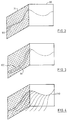
- Such a displayed image is shown in Fig. 1.
- two slices are shown as the left side surface 70 and back surface 80 of the projected cuboid.
- the system is arranged so that if a feature such as the intersection of a surface with the slice displayed on the left face is identifiable by the user, the user can register the position of this intersection and cause it to be displayed on the screen by "drawing in” the intersection using mouse 30.
- the registered position is the position of the cursor on the 2-D slice. This "drawn-in" line is indicated on Figure 1 at 90.
- the user can cause the display of a neighbouring slice in the data set by a user input operation.
- the user clicks on a mouse button and the co-ordinate of the displayed slice in the third dimension of the cuboid is incremented.
- the previously drawn line is retained in the image, but is displaced in the cuboid.
- Figure 3 The user can then proceed to identify the intersection of the surface with the newly displayed slice and draw in its position in a similar manner as displayed line 100.
- the user input operation could be the operation of the mouse when the cursor is positioned over a suitable icon.
- a representation 110 of the surface may be extruded from the volume as shown in Figure 4.
- the positions of the identified intersections, and thus of the surface, are at the same time stored in an appropriate form in disk storage unit 60.
Landscapes
- Physics & Mathematics (AREA)
- Engineering & Computer Science (AREA)
- Computer Graphics (AREA)
- Geometry (AREA)
- Software Systems (AREA)
- General Physics & Mathematics (AREA)
- Theoretical Computer Science (AREA)
- Processing Or Creating Images (AREA)
- Apparatus For Radiation Diagnosis (AREA)
Description
Claims (6)
- Interactive data interpretation tool for enabling the identification of the position of a feature in a three multidimensional image data set, the tool comprising:means for displaying an image representing a first 2-D slice of the data set whereby the 2-D slice corresponds to a 2-D subset of said 3-D data set for which the coordinate of one of said three dimensions is constant;user input means for causing the storage of the position of a feature in the displayed image;means operable in response to a predetermined user input operation to cause the co-ordinate of the currently displayed 2-D slice in the said one of said three dimensions of the 3-D image to be incremented whereby said means for displaying displays an incremental 2-D slice of said 3-D data set corresponding to the incremented co-ordinate; andmeans for indicating the position of the feature for said first 2-D slice so as to provide an indication to the user of the position of the feature in said incremental slice.
- Interactive data interpretation tool as claimed in Claim 1 wherein the predetermined user input operation is the pressing of a mouse button or a key on a keyboard when the display cursor is positioned over a predetermined area of the display.
- Interactive data interpretation tool as claimed in claim 1 or claim 2 wherein the user input means is operable when the display cursor is positioned over the displayed 2-D slice to cause the storage of the position on the 2-D slice of the display cursor as the position of the feature.
- Interactive data interpretation tool as claimed in any preceding claim wherein the features to be identified are the intersection of a surface with the displayed 2-D slice wherein the means for indicating causes the display of a line at the position in the 3-D image of previously identified such intersections.
- Interactive data interpretation tool as claimed in any preceding claim including storage means for storing the multidimensional data set and the positions of the identified features.
- Interactive data interpretation tool as claimed in any preceding claim in the form of a computer graphics workstation.
Priority Applications (2)
| Application Number | Priority Date | Filing Date | Title |
|---|---|---|---|
| EP19920301044 EP0554596B1 (en) | 1992-02-07 | 1992-02-07 | Interactive multidimensional data interpretation tool |
| DE1992625789 DE69225789T2 (en) | 1992-02-07 | 1992-02-07 | Interactive device for evaluating multidimensional data |
Applications Claiming Priority (1)
| Application Number | Priority Date | Filing Date | Title |
|---|---|---|---|
| EP19920301044 EP0554596B1 (en) | 1992-02-07 | 1992-02-07 | Interactive multidimensional data interpretation tool |
Publications (2)
| Publication Number | Publication Date |
|---|---|
| EP0554596A1 EP0554596A1 (en) | 1993-08-11 |
| EP0554596B1 true EP0554596B1 (en) | 1998-06-03 |
Family
ID=8211264
Family Applications (1)
| Application Number | Title | Priority Date | Filing Date |
|---|---|---|---|
| EP19920301044 Expired - Lifetime EP0554596B1 (en) | 1992-02-07 | 1992-02-07 | Interactive multidimensional data interpretation tool |
Country Status (2)
| Country | Link |
|---|---|
| EP (1) | EP0554596B1 (en) |
| DE (1) | DE69225789T2 (en) |
Families Citing this family (1)
| Publication number | Priority date | Publication date | Assignee | Title |
|---|---|---|---|---|
| CN114663432B (en) * | 2022-05-24 | 2022-08-16 | 武汉泰乐奇信息科技有限公司 | Skeleton model correction method and device |
Family Cites Families (1)
| Publication number | Priority date | Publication date | Assignee | Title |
|---|---|---|---|---|
| US5150457A (en) * | 1990-05-02 | 1992-09-22 | International Business Machines Corporation | Enhanced visualization using translucent contour surfaces |
-
1992
- 1992-02-07 EP EP19920301044 patent/EP0554596B1/en not_active Expired - Lifetime
- 1992-02-07 DE DE1992625789 patent/DE69225789T2/en not_active Expired - Lifetime
Also Published As
| Publication number | Publication date |
|---|---|
| EP0554596A1 (en) | 1993-08-11 |
| DE69225789T2 (en) | 1999-02-25 |
| DE69225789D1 (en) | 1998-07-09 |
Similar Documents
| Publication | Publication Date | Title |
|---|---|---|
| US5546529A (en) | Method and apparatus for visualization of database search results | |
| US5463726A (en) | Method and apparatus for graphic accessing of multiple software applications | |
| EP0752640B1 (en) | Representation of inter-relationships between graphical objects in a computer display device | |
| US6259458B1 (en) | Method of generating and navigating a 3-D representation of a hierarchical data structure | |
| US5473747A (en) | Method and apparatus for identifying features in a multidimensional data set | |
| CA2299896C (en) | Selection navigator | |
| US20030098881A1 (en) | System and method for implementing a three-dimensional graphic user interface | |
| US5412775A (en) | Display control method and apparatus determining corresponding validity of windows or operations | |
| CN103814398B (en) | The positioning indicator of the daughter for multidimensional image in the GUI used in image procossing | |
| US20120287121A1 (en) | Method for designing a geometrical three-dimensional modeled object | |
| KR20090007623A (en) | Geographic Information System and Related Methods for Representing Images in 3D Geospatial with Reference Markers | |
| EP0455439A2 (en) | Computer method and system for analysing real or simulated physical systems | |
| EP0595746A1 (en) | Method and system for input device pressure indication in a data processing system | |
| EP0316144B1 (en) | Method and apparatus for classifying graphics segments to facilitate pick and display operation | |
| US7620638B2 (en) | Process for selecting an object in a PLM database and apparatus implementing this process | |
| US20070168392A1 (en) | Process for displaying objects of a PLM database and apparatus implementing this process | |
| US7420556B2 (en) | Information processing method and information processing apparatus | |
| EP0714057B1 (en) | Method and apparatus for displaying a cursor along a two dimensional representation of a computer generated three dimensional surface | |
| US7502027B1 (en) | Electronic drawing viewer | |
| US20040135974A1 (en) | System and architecture for displaying three dimensional data | |
| EP0554596A1 (en) | Interactive multidimensional data interpretation tool | |
| CA2128578C (en) | Method and system for producing a table image having focus and context areas showing direct and indirect data representations | |
| GB2238215A (en) | Computer display system with a three dimensional cursor shadow | |
| US20060085733A1 (en) | Document display device, method, and program product | |
| Ropinski et al. | Interactive volume visualization techniques for subsurface data |
Legal Events
| Date | Code | Title | Description |
|---|---|---|---|
| PUAI | Public reference made under article 153(3) epc to a published international application that has entered the european phase |
Free format text: ORIGINAL CODE: 0009012 |
|
| AK | Designated contracting states |
Kind code of ref document: A1 Designated state(s): DE FR GB |
|
| 17P | Request for examination filed |
Effective date: 19931221 |
|
| GRAG | Despatch of communication of intention to grant |
Free format text: ORIGINAL CODE: EPIDOS AGRA |
|
| 17Q | First examination report despatched |
Effective date: 19970825 |
|
| GRAG | Despatch of communication of intention to grant |
Free format text: ORIGINAL CODE: EPIDOS AGRA |
|
| GRAH | Despatch of communication of intention to grant a patent |
Free format text: ORIGINAL CODE: EPIDOS IGRA |
|
| GRAH | Despatch of communication of intention to grant a patent |
Free format text: ORIGINAL CODE: EPIDOS IGRA |
|
| GRAA | (expected) grant |
Free format text: ORIGINAL CODE: 0009210 |
|
| AK | Designated contracting states |
Kind code of ref document: B1 Designated state(s): DE FR GB |
|
| REF | Corresponds to: |
Ref document number: 69225789 Country of ref document: DE Date of ref document: 19980709 |
|
| ET | Fr: translation filed | ||
| PLBE | No opposition filed within time limit |
Free format text: ORIGINAL CODE: 0009261 |
|
| 26N | No opposition filed | ||
| REG | Reference to a national code |
Ref country code: GB Ref legal event code: IF02 |
|
| PGFP | Annual fee paid to national office [announced via postgrant information from national office to epo] |
Ref country code: FR Payment date: 20030217 Year of fee payment: 12 |
|
| PG25 | Lapsed in a contracting state [announced via postgrant information from national office to epo] |
Ref country code: FR Free format text: LAPSE BECAUSE OF NON-PAYMENT OF DUE FEES Effective date: 20041029 |
|
| REG | Reference to a national code |
Ref country code: FR Ref legal event code: ST |
|
| REG | Reference to a national code |
Ref country code: GB Ref legal event code: 732E |
|
| PGFP | Annual fee paid to national office [announced via postgrant information from national office to epo] |
Ref country code: DE Payment date: 20110208 Year of fee payment: 20 |
|
| PGFP | Annual fee paid to national office [announced via postgrant information from national office to epo] |
Ref country code: GB Payment date: 20110209 Year of fee payment: 20 |
|
| REG | Reference to a national code |
Ref country code: DE Ref legal event code: R071 Ref document number: 69225789 Country of ref document: DE |
|
| REG | Reference to a national code |
Ref country code: DE Ref legal event code: R071 Ref document number: 69225789 Country of ref document: DE |
|
| REG | Reference to a national code |
Ref country code: GB Ref legal event code: PE20 Expiry date: 20120206 |
|
| PG25 | Lapsed in a contracting state [announced via postgrant information from national office to epo] |
Ref country code: DE Free format text: LAPSE BECAUSE OF EXPIRATION OF PROTECTION Effective date: 20120208 |
|
| PG25 | Lapsed in a contracting state [announced via postgrant information from national office to epo] |
Ref country code: GB Free format text: LAPSE BECAUSE OF EXPIRATION OF PROTECTION Effective date: 20120206 |