CN216896628U - Geographic information engineering survey and drawing cloud platform - Google Patents
Geographic information engineering survey and drawing cloud platform Download PDFInfo
- Publication number
- CN216896628U CN216896628U CN202123030321.0U CN202123030321U CN216896628U CN 216896628 U CN216896628 U CN 216896628U CN 202123030321 U CN202123030321 U CN 202123030321U CN 216896628 U CN216896628 U CN 216896628U
- Authority
- CN
- China
- Prior art keywords
- support rod
- support
- geographic information
- connecting frame
- information engineering
- Prior art date
- Legal status (The legal status is an assumption and is not a legal conclusion. Google has not performed a legal analysis and makes no representation as to the accuracy of the status listed.)
- Expired - Fee Related
Links
- 238000013507 mapping Methods 0.000 claims abstract description 29
- 238000009434 installation Methods 0.000 claims abstract description 6
- 238000010586 diagram Methods 0.000 description 2
- 230000009286 beneficial effect Effects 0.000 description 1
- 230000005540 biological transmission Effects 0.000 description 1
- 238000009435 building construction Methods 0.000 description 1
- 238000000034 method Methods 0.000 description 1
Images


Landscapes
- Sampling And Sample Adjustment (AREA)
Abstract
本实用新型提供一种地理信息工程测绘云台,属于测绘领域。包括支撑架、固定台,固定台置于支撑架上,支撑架包括上支撑结构、下支撑底座,上支撑结构铰接置于下支撑底座上,下支撑底座为三角支架结构,包括两个下支撑杆、连接架、前支撑杆,连接架上设置有两个铰接孔,前支撑杆一端插接置于连接架上,前支撑杆另一端向下折弯,前导轮通过安装套置于前支撑杆另一端上,两个下支撑杆的一端对应铰接置于连接架上,且和连接架上的铰接孔对应,下支撑杆之间通过间歇齿盘对应啮合,下支撑杆的另一端对应设置有下铰接端,下铰接端相对下支撑杆回转,能够进行折叠收纳,进行移动携带。
The utility model provides a geographic information engineering surveying and mapping cloud platform, which belongs to the field of surveying and mapping. It includes a support frame and a fixed platform. The fixed platform is placed on the support frame. The support frame includes an upper support structure and a lower support base. The upper support structure is hinged and placed on the lower support base. The lower support base is a triangular support structure, including two lower supports. Rod, connecting frame, front support rod, the connecting frame is provided with two hinge holes, one end of the front support rod is inserted on the connecting frame, the other end of the front support rod is bent downward, and the front guide wheel is placed on the front support through the installation sleeve On the other end of the rod, one end of the two lower support rods is correspondingly hinged on the connecting frame, and corresponds to the hinge hole on the connecting frame. There is a lower hinged end, and the lower hinged end is rotated relative to the lower support rod, and can be folded and stored for mobile carrying.
Description
技术领域technical field
本实用新型提供一种地理信息工程测绘云台,属于测绘领域。The utility model provides a geographic information engineering surveying and mapping cloud platform, which belongs to the field of surveying and mapping.
背景技术Background technique
目前,在进行地理信息测绘时,部分环境需要进行实地测绘,通过携带三脚架、测绘仪等设备进行测绘,现有的测绘三脚架结构为三根支杆形成支撑,不能够进行移动,且需要通过三个点进行支撑固定,不能够形成单点悬空测绘,尤其是在部分边缘位置是,上述结构不利于测绘仪的固定支撑。At present, when conducting geographic information surveying and mapping, some environments need to be surveyed and mapped on the spot, by carrying tripods, surveyors and other equipment for surveying and mapping. The existing surveying and mapping tripod structure is supported by three poles, which cannot be moved, and requires three Points are supported and fixed, and single-point suspended surveying and mapping cannot be formed, especially in some edge positions, the above structure is not conducive to the fixed support of the surveying and mapping instrument.
公开号CN213745862U公开了一种建筑施工用便携式测量仪,具体涉及测量仪器设备领域,包括固定台、测量仪主体和支架固定块,所述固定台底部一侧外壁固定设有竖直向下的固定柱,所述固定柱底部一端固定设有升降柱,所述升降柱底部一端和支架固定块顶部一端固定,所述升降柱底部一侧外壁套接有固定转动环,所述支架固定块一侧外壁开设有等距离分布的支架放置槽,上述公开结构中,采用三点支撑,不能够适用悬空结构的支撑测绘。Publication No. CN213745862U discloses a portable measuring instrument for building construction, in particular to the field of measuring instruments and equipment, including a fixing table, a measuring instrument main body and a bracket fixing block. One end of the bottom of the fixed column is fixed with a lifting column, one end of the bottom of the lifting column is fixed with one end of the top of the bracket fixing block, the outer wall of one side of the bottom of the lifting column is sleeved with a fixed rotating ring, and one side of the bracket fixing block The outer wall is provided with equidistant bracket placement slots. In the above disclosed structure, three-point support is adopted, which cannot be applied to the support surveying and mapping of the suspended structure.
实用新型内容Utility model content
本实用新型一种地理信息工程测绘云台,提供的一种通过杆体结构的铰接,进行扩展支撑,形成云台支撑的测绘云台。结构简单,使用方便。The utility model relates to a geographic information engineering surveying and mapping pan-tilt, which provides a surveying and mapping pan-tilt supported by the pan-tilt structure through the hinged connection of the rod body structure for extended support. Simple structure and convenient use.
本实用新型一种地理信息工程测绘云台是这样实现的,本实用新型一种地理信息工程测绘云台:包括支撑架、固定台,固定台置于支撑架上,支撑架包括上支撑结构、下支撑底座,上支撑结构铰接置于下支撑底座上,下支撑底座为三角支架结构,包括两个下支撑杆、连接架、前支撑杆,连接架上设置有两个铰接孔,前支撑杆一端插接置于连接架上,前支撑杆另一端向下折弯,前导轮通过安装套置于前支撑杆另一端上,两个下支撑杆的一端对应铰接置于连接架上,且和连接架上的铰接孔对应,下支撑杆之间通过间歇齿盘对应啮合,下支撑杆的另一端对应设置有下铰接端,下铰接端相对下支撑杆回转,上支撑结构对应铰接置于下铰接端上,上支撑结构包括两个上支撑杆,上支撑杆的低端设置有上铰接端,上铰接端和下铰接端对应铰接,上支撑杆的顶端设置有连接弯头,固定台对应置于连接弯头上,连接弯头上对应设置有第一间歇齿盘、第二间歇齿盘,第一间歇齿盘、第二间歇齿盘相对啮合,第一间歇齿盘、第二间歇齿盘对应铰接置于固定台上,固定台为环状结构,边缘设置有多个安装孔;A geographic information engineering surveying and mapping cloud platform of the present invention is realized in this way. The utility model provides a geographic information engineering surveying and mapping cloud platform: comprising a support frame and a fixed platform, the fixed platform is placed on the support frame, and the support frame includes an upper support structure, The lower support base, the upper support structure is hingedly placed on the lower support base, and the lower support base is a triangular bracket structure, including two lower support rods, a connecting frame, and a front support rod. The connecting frame is provided with two hinge holes, and the front support rod One end is inserted and placed on the connecting frame, the other end of the front support rod is bent downward, the front guide wheel is placed on the other end of the front support rod through the installation sleeve, and one end of the two lower support rods is correspondingly hinged on the connecting frame, and the The hinge holes on the connecting frame correspond to each other, the lower support rods are meshed correspondingly through intermittent toothed discs, the other end of the lower support rod is correspondingly provided with a lower hinge end, the lower hinge end rotates relative to the lower support rod, and the upper support structure is hinged and placed at the bottom correspondingly. On the hinged end, the upper support structure includes two upper support rods, the lower end of the upper support rod is provided with an upper hinged end, the upper hinged end and the lower hinged end are correspondingly hinged, the top of the upper support rod is provided with a connecting elbow, and the fixing table corresponds to It is placed on the connecting elbow, and the connecting elbow is correspondingly provided with a first intermittent toothed disc and a second intermittent toothed disc. The plate is correspondingly hinged on the fixing table, the fixing table is a ring structure, and the edge is provided with a plurality of installation holes;
所述上铰接端、下铰接端之间设置有回转限位组件,所述回转限位组件设置有一个固定盘,固定盘置于上铰接端上,固定盘内圈等角度设置有凹槽,下铰接端上设置有弹性端子,弹性端子对应凹槽,且底部设置有支撑弹簧;A rotation limit assembly is arranged between the upper hinge end and the lower hinge end, the rotation limit assembly is provided with a fixed plate, the fixed plate is placed on the upper hinge end, and the inner ring of the fixed plate is provided with grooves at equal angles, An elastic terminal is arranged on the lower hinge end, the elastic terminal corresponds to the groove, and a supporting spring is arranged at the bottom;
所述上铰接端和上支撑架之间设置有弹簧管,且通过弹簧管连接固定;A spring tube is arranged between the upper hinge end and the upper support frame, and is connected and fixed by the spring tube;
所述上支撑杆为伸缩杆,且中部设置有防滑套;The upper support rod is a telescopic rod, and the middle part is provided with a non-slip sleeve;
所述前导轮为万向轮;The front guide wheel is a universal wheel;
所述前支撑杆和连接架之间设置有插销,前支撑杆上设置有多个销孔;A latch is arranged between the front support rod and the connecting frame, and a plurality of pin holes are arranged on the front support rod;
所述连接弯头相对上支撑杆回转。The connecting elbow rotates relative to the upper support rod.
有益效果:Beneficial effects:
一、能够进行折叠收纳,进行移动携带;1. It can be folded and stored for mobile carrying;
二、支撑后,能够进行移动;2. After being supported, it can be moved;
三、结构简单,使用方便。Third, the structure is simple and easy to use.
附图说明Description of drawings
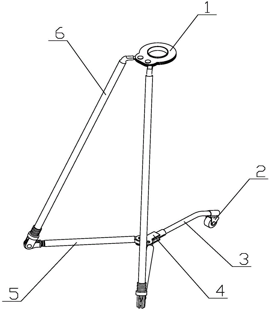
图1为本实用新型一种地理信息工程测绘云台的立体结构图。FIG. 1 is a three-dimensional structural diagram of a geographic information engineering surveying and mapping cloud platform of the present invention.
图2为本实用新型一种地理信息工程测绘云台的侧视图。FIG. 2 is a side view of a geographic information engineering surveying and mapping cloud platform of the present invention.
图3为本实用新型一种地理信息工程测绘云台的间歇齿盘的结构示意图。3 is a schematic structural diagram of an intermittent toothed disc of a geographic information engineering surveying and mapping head of the present invention.
图4为本实用新型一种地理信息工程测绘云台的仰视图。4 is a bottom view of a geographic information engineering surveying and mapping cloud platform of the present invention.
附图中:In the attached picture:
1、固定台;2、前导轮;3、前支撑杆;4、连接架;5、下支撑杆;6、上支撑杆;7、连接弯头;8、上铰接端;9、下铰接端;10、安装套;11、第一间歇齿盘;12、第二间歇齿盘;13、连接孔;14、连接轴。1. Fixed table; 2. Front guide wheel; 3. Front support rod; 4. Connecting frame; 5. Lower support rod; 6. Upper support rod; 7. Connecting elbow; 8. Upper hinged end; 9. Lower hinged
具体实施方式Detailed ways
下面结合附图对本实用新型进一步说明。The present utility model will be further described below in conjunction with the accompanying drawings.
根据图1-4所示:本实用新型一种地理信息工程测绘云台是这样实现的,本实用新型一种地理信息工程测绘云台:包括支撑架、固定台1,固定台1置于支撑架上,支撑架包括上支撑结构、下支撑底座,上支撑结构铰接置于下支撑底座上,下支撑底座为三角支架结构,包括两个下支撑杆5、连接架4、前支撑杆3,连接架4上设置有两个铰接孔,前支撑杆3一端插接置于连接架4上,前支撑杆3另一端向下折弯,前导轮2通过安装套10置于前支撑杆 3另一端上,两个下支撑杆5的一端对应铰接置于连接架4上,且和连接架4上的铰接孔对应,下支撑杆5之间通过间歇齿盘对应啮合,下支撑杆5的另一端对应设置有下铰接端9,下铰接端9相对下支撑杆回转,上支撑结构对应铰接置于下铰接端9上,上支撑结构包括两个上支撑杆6,上支撑杆6的低端设置有上铰接端8,上铰接端8和下铰接端9对应铰接,上支撑杆6的顶端设置有连接弯头7,固定台1对应置于连接弯头7上,连接弯头7上对应设置有第一间歇齿盘11、第二间歇齿盘12,第一间歇齿盘11、第二间歇齿盘12相对啮合,第一间歇齿盘11、第二间歇齿盘12对应铰接置于固定台1上,固定台1为环状结构,边缘设置有多个安装孔;As shown in Figure 1-4: a geographic information engineering surveying and mapping cloud platform of the present utility model is realized in this way, a geographic information engineering surveying and mapping cloud platform of the present utility model includes a support frame and a
所述上铰接端8、下铰接端9之间设置有回转限位组件,所述回转限位组件设置有一个固定盘,固定盘置于上铰接端8上,固定盘内圈等角度设置有凹槽,下铰接端9上设置有弹性端子,弹性端子对应凹槽,且底部设置有支撑弹簧;A rotation limit assembly is arranged between the
所述上铰接端8和上支撑架之间设置有弹簧管,且通过弹簧管连接固定;A spring tube is arranged between the
所述上支撑杆6为伸缩杆,且中部设置有防滑套;The
所述前导轮2为万向轮,能够形成调节移动;The
所述前支撑杆3和连接架4之间设置有插销,前支撑杆3上设置有多个销孔;A latch is provided between the
所述连接弯头7相对上支撑杆6回转,能够通过连接弯头7和上支撑杆6的回转,调节上支撑杆6的角度;The connecting
使用时,初始状态为上支撑杆6闭合,下支撑杆5闭合,且和上支撑杆6贴合,前支撑杆3竖直设置,前导轮2置于固定台1下方,通过将测绘仪安装在固定台1上,将前支撑杆3 翻转,通过连接架4带动下支撑杆5偏转,下支撑杆5通过上铰接端8、下铰接端9对应偏转,使得上支撑杆6、下支撑杆5之间形成夹角,然后通过将上支撑杆6、下支撑杆5对应打开,通过第一间歇齿盘11、第二间歇磁盘形成传动,进行偏转,形成支撑,通过调节固定台 1进行测绘,在移动时,通过将两个上支撑杆6上提,使得前导轮2和地面接触,并通过移动对测绘仪进行移动,使用完毕后进行折叠收纳,通过下支撑杆5和底面形成线性结构,通过两条不平行的线形成面支撑,能够满足第三点悬空支撑的场合,达到便于折叠收纳的目的。When in use, the initial state is that the
以上对本实用新型及其实施方式进行了描述,这种描述没有限制性,附图中所示的也只是本实用新型的实施方式之一,实际的结构并不局限于此。总而言之如果本领域的普通技术人员受其启示,在不脱离本实用新型创造宗旨的情况下,不经创造性的设计出与该技术方案相似的结构方式及实施例,均应属于本实用新型的保护范围。The present invention and the embodiments thereof have been described above, and the description is not restrictive, and what is shown in the accompanying drawings is only one of the embodiments of the present invention, and the actual structure is not limited thereto. All in all, if those of ordinary skill in the art are inspired by it, without departing from the purpose of the present invention, and without creatively designing the structure and embodiment similar to this technical scheme, all should belong to the protection of the present invention. scope.
Claims (7)
Priority Applications (1)
| Application Number | Priority Date | Filing Date | Title |
|---|---|---|---|
| CN202123030321.0U CN216896628U (en) | 2021-12-03 | 2021-12-03 | Geographic information engineering survey and drawing cloud platform |
Applications Claiming Priority (1)
| Application Number | Priority Date | Filing Date | Title |
|---|---|---|---|
| CN202123030321.0U CN216896628U (en) | 2021-12-03 | 2021-12-03 | Geographic information engineering survey and drawing cloud platform |
Publications (1)
| Publication Number | Publication Date |
|---|---|
| CN216896628U true CN216896628U (en) | 2022-07-05 |
Family
ID=82205278
Family Applications (1)
| Application Number | Title | Priority Date | Filing Date |
|---|---|---|---|
| CN202123030321.0U Expired - Fee Related CN216896628U (en) | 2021-12-03 | 2021-12-03 | Geographic information engineering survey and drawing cloud platform |
Country Status (1)
| Country | Link |
|---|---|
| CN (1) | CN216896628U (en) |
-
2021
- 2021-12-03 CN CN202123030321.0U patent/CN216896628U/en not_active Expired - Fee Related
Similar Documents
| Publication | Publication Date | Title |
|---|---|---|
| CN113217783B (en) | Drawing auxiliary instrument for archaeological measurement | |
| CN212747697U (en) | Three-dimensional laser scanner for supervision of construction engineering | |
| CN211083484U (en) | Mapping instrument positioning device for engineering mapping | |
| CN219346050U (en) | A stable support structure for engineering surveying equipment | |
| CN211651625U (en) | A surveying, mapping, and lofting device | |
| CN113431991A (en) | A mapping device for open-air survey engineering | |
| CN206450225U (en) | A kind of urban and rural planning mapping support meanss | |
| CN213118312U (en) | Centering rod support for surveying and mapping | |
| CN109520488A (en) | A kind of Multifunctional mapping instrument | |
| CN220416895U (en) | Surveying instrument with adjustable complicated topography | |
| CN219045679U (en) | A surveying and mapping device suitable for multi-terrain for land survey | |
| CN219013802U (en) | Vertical mapping device of geographical survey and drawing convenient to it is fixed | |
| CN210860402U (en) | An improved lifting device for geographic surveying and mapping instruments | |
| CN206369554U (en) | A kind of mapping support for being adapted to field mapping | |
| CN221974909U (en) | Be used for electric power engineering reconnaissance RTK measuring apparatu | |
| CN215569509U (en) | Adjustable all-dimensional surveying instrument | |
| CN221897544U (en) | A road surveying and mapping device for garden landscape | |
| CN211166131U (en) | Angle-automatically-adjustable surveying and mapping platform | |
| CN220488740U (en) | An on-site surveying and mapping device | |
| CN218845651U (en) | Supporting foot frame for engineering measurement | |
| CN222334974U (en) | Mapping device for geological survey | |
| CN219933612U (en) | Land surveying instrument | |
| CN213420467U (en) | Support device firm in placement | |
| CN214173369U (en) | Surveying instrument positioning device for surveying and mapping | |
| CN221526188U (en) | Installer for geographic information equipment |
Legal Events
| Date | Code | Title | Description |
|---|---|---|---|
| GR01 | Patent grant | ||
| GR01 | Patent grant | ||
| CF01 | Termination of patent right due to non-payment of annual fee |
Granted publication date: 20220705 |
|
| CF01 | Termination of patent right due to non-payment of annual fee |