CN115855006B - Geographic information mapping tool for power grid planning - Google Patents
Geographic information mapping tool for power grid planning Download PDFInfo
- Publication number
- CN115855006B CN115855006B CN202310141478.5A CN202310141478A CN115855006B CN 115855006 B CN115855006 B CN 115855006B CN 202310141478 A CN202310141478 A CN 202310141478A CN 115855006 B CN115855006 B CN 115855006B
- Authority
- CN
- China
- Prior art keywords
- frame
- power
- surveying
- mapping
- drilling
- Prior art date
- Legal status (The legal status is an assumption and is not a legal conclusion. Google has not performed a legal analysis and makes no representation as to the accuracy of the status listed.)
- Expired - Fee Related
Links
Images
Classifications
-
- Y—GENERAL TAGGING OF NEW TECHNOLOGICAL DEVELOPMENTS; GENERAL TAGGING OF CROSS-SECTIONAL TECHNOLOGIES SPANNING OVER SEVERAL SECTIONS OF THE IPC; TECHNICAL SUBJECTS COVERED BY FORMER USPC CROSS-REFERENCE ART COLLECTIONS [XRACs] AND DIGESTS
- Y04—INFORMATION OR COMMUNICATION TECHNOLOGIES HAVING AN IMPACT ON OTHER TECHNOLOGY AREAS
- Y04S—SYSTEMS INTEGRATING TECHNOLOGIES RELATED TO POWER NETWORK OPERATION, COMMUNICATION OR INFORMATION TECHNOLOGIES FOR IMPROVING THE ELECTRICAL POWER GENERATION, TRANSMISSION, DISTRIBUTION, MANAGEMENT OR USAGE, i.e. SMART GRIDS
- Y04S10/00—Systems supporting electrical power generation, transmission or distribution
- Y04S10/50—Systems or methods supporting the power network operation or management, involving a certain degree of interaction with the load-side end user applications
Landscapes
- Position Fixing By Use Of Radio Waves (AREA)
- Earth Drilling (AREA)
Abstract
本发明涉及地理信息测绘工具技术领域,提出了一种电网规划用地理信息测绘工具,其能够实时接入大数据,充分利用上云技术优化测绘数据的存储和处理,在实现地表信息测绘的同时可以实现地下信息和高空信息的测绘,从而实现多维信息的涵盖,地理信息测绘较为健全,为后续的电网规划提供的参考数据较为丰富,包括机箱,机箱内安装有测绘本体,还包括车架,车架上安装有机械臂,机械臂上安装有连接板,机箱与连接板连接,车架的顶端开设有钻探孔和方孔,钻探孔位于机械臂的后侧,方孔位于钻探孔的后侧,车架内安装有动力组件,动力组件上安装有动力筒,动力筒穿过钻探孔伸出至车架的上方,且动力筒内设置有钻探杆,钻探杆的顶端开设有顶螺纹槽。

The invention relates to the technical field of geographic information surveying and mapping tools, and proposes a geographic information surveying and mapping tool for power grid planning, which can access big data in real time, fully utilizes cloud technology to optimize the storage and processing of surveying and mapping data, and realizes surface information surveying and mapping at the same time It can realize the surveying and mapping of underground information and high-altitude information, so as to realize the coverage of multi-dimensional information. The geographic information surveying and mapping is relatively sound, and the reference data provided for subsequent power grid planning is relatively rich, including the chassis, which is equipped with a surveying and mapping body and a vehicle frame. A mechanical arm is installed on the frame, and a connection plate is installed on the mechanical arm. The chassis is connected to the connection plate. There are drilling holes and square holes on the top of the frame. On the side, a power assembly is installed in the frame, and a power cylinder is installed on the power assembly. The power cylinder extends to the top of the frame through the drilling hole, and a drilling rod is arranged in the power cylinder, and a top thread groove is opened on the top of the drilling rod. .
Description
技术领域technical field
本发明涉及地理信息测绘工具技术领域,具体涉及一种电网规划用地理信息测绘工具。The invention relates to the technical field of geographic information surveying and mapping tools, in particular to a geographic information surveying and mapping tool for grid planning.
背景技术Background technique
众所周知,在电网规划前为便于电网的设计和布局,通常需要对相应区域的地理信息进行测绘,以方便电网规划作业过程中线路经过地点的选取,而地理信息测绘过程中,通常会使用电网规划用地理信息测绘工具进行辅助测量。As we all know, in order to facilitate the design and layout of the power grid before power grid planning, it is usually necessary to survey and map the geographic information of the corresponding area, so as to facilitate the selection of the line passing location in the process of power grid planning. Auxiliary measurement with geographic information mapping tools.
经检索,2022年5月13日公开的,公开号为CN112212838B的中国专利专利公开了一种电网规划用地理信息测绘工具,其大致描述为,包括座板及设置于座板上端的机箱,机箱内设有测绘本体,座板下侧设有长度可调节的支柱,座板下侧设有若干连接转块,若干连接转块均分别与长度可调节的支架转动连接,其中一个支架上设有握把,座板内设有驱动支柱长度进行调节的双向电机,支柱周向转动连接有若干转杆,若干转杆均分别与移动块转动连接,移动块与支架滑动连接,支架上设有供移动块滑动和收纳转杆的移动槽,座板内设有水平检测器、控制面板和总控端,机箱内设有对测绘本体进行防震缓冲的缓冲组件,机箱上端通过若干第三弹簧与测绘本体连接,其在使用时,将整个装置上立柱与地面接触使其立在地面上,此时按动控制面板上的按钮使得总控端控制双向电机启动,双向电机的下输出端转动使得第一丝杠转动,第一丝杠转动使得与之螺纹连接的第一滑块沿其下移,进而使得与第一滑块固定连接的下柱下移,实现支柱的长度调节,在第一滑块下移时,通过转杆的连接作用,使得与转杆转动的连接转块在支架上的移动槽中移动,连接转块移动至极限位置时,通过转杆的支撑使得三个支架张开,直至三个支架将整个装置支撑,此时座板上的水平检测器工作对座板的水平平整度进行检测,进而通过总控端的无线传输模块发出信号,使得三个支架内的控制端的无线接收模块接受信号后控制第一电机启动,第一电机输出端转动使得与之固定连接的第二丝杠转动,第二丝杠转动使得与之螺纹连接的第二滑块沿其上下移动,进而使得上架和下架相互靠近和远离,上筒和下块相靠近和远离,实现支架的长度调节,进而度座板的水平度进行调节,设置于机箱内的测绘本体在进行工作时,通过机箱内的第一弹簧、第二弹簧和第三弹簧的弹力作用进行缓冲减震。After retrieval, the Chinese patent patent published on May 13, 2022 with the publication number CN112212838B discloses a geographical information surveying and mapping tool for power grid planning, which is roughly described as including a seat board and a chassis arranged on the top of the seat board. There is a surveying and mapping body inside. There are length-adjustable pillars on the underside of the seat plate. There are several connecting blocks on the underside of the seat plate. These connecting blocks are respectively connected to the brackets with adjustable length. One of the brackets has a The handle and the seat plate are provided with a two-way motor that drives the length of the pillar to adjust. The pillar is rotated in the circumferential direction and connected with a number of rotating rods. The moving block slides and accommodates the moving slot of the rotating rod. The seat plate is equipped with a level detector, a control panel and a master control terminal. The chassis is equipped with a buffer component for shockproof buffering of the surveying and mapping body. The upper end of the chassis passes through several third springs and surveying and mapping. The main body is connected. When in use, the upper column of the whole device is in contact with the ground to make it stand on the ground. At this time, press the button on the control panel to make the master control end control the two-way motor to start, and the lower output end of the two-way motor rotates to make the second The screw rotates, and the first screw rotates to make the first slider screwed with it move down along it, and then the lower column fixedly connected with the first slider moves down to realize the length adjustment of the column. When the block moves down, through the connection of the rotating rod, the connecting rotating block that rotates with the rotating rod moves in the moving groove on the bracket. When the connecting rotating block moves to the limit position, the three brackets are opened through the support of the rotating rod. Until the whole device is supported by the three brackets, the level detector on the seat board works to detect the level flatness of the seat board, and then sends a signal through the wireless transmission module of the master control terminal, so that the wireless reception of the control terminal in the three brackets After receiving the signal, the module controls the first motor to start, the output end of the first motor rotates to make the second lead screw fixedly connected to it rotate, and the second lead screw rotates to make the second slider screwed with it move up and down along it, thereby making the The upper frame and the lower frame are close to and far away from each other, and the upper cylinder and the lower block are close to and far away from each other to realize the adjustment of the length of the bracket, and then adjust the level of the seat plate. The elastic force of the first spring, the second spring and the third spring performs buffering and shock absorption.
上述的现有技术方案虽然能够用于电网规划前的地理信息的辅助测绘,但是伴随着大数据的成熟,如何充分利用大数据,实现测量数据的上云存储成为优化测量和后续数据处理的重要需求之一,而对此上述的技术方案中的对应功能较为薄弱,同时地理信息涵盖了地表、高空和地下多维信息,而上述的技术方案则较难实现多维信息的采集,实用性较差。Although the above existing technical solutions can be used for auxiliary surveying and mapping of geographic information before power grid planning, with the maturity of big data, how to make full use of big data and realize cloud storage of measurement data has become an important issue for optimizing measurement and subsequent data processing. One of the requirements, and the corresponding functions in the above-mentioned technical solutions are relatively weak. At the same time, geographic information covers multi-dimensional information on the surface, high-altitude and underground. However, the above-mentioned technical solutions are difficult to realize the collection of multi-dimensional information, and the practicability is poor.
发明内容Contents of the invention
(一)解决的技术问题(1) Solved technical problems
针对现有技术的不足,本发明提供了一种电网规划用地理信息测绘工具,其能够实时接入大数据,充分利用上云技术优化测绘数据的存储和处理,并且在实现地表信息测绘的同时可以实现地下信息和高空信息的测绘,从而实现多维信息的涵盖,地理信息测绘较为健全,为后续的电网规划提供的参考数据较为丰富。Aiming at the deficiencies of the prior art, the present invention provides a geographic information surveying and mapping tool for power grid planning, which can access big data in real time, fully utilize cloud technology to optimize the storage and processing of surveying and mapping data, and realize surface information surveying and mapping at the same time It can realize the surveying and mapping of underground information and high-altitude information, so as to realize the coverage of multi-dimensional information. The geographic information surveying and mapping is relatively sound, and the reference data provided for subsequent power grid planning is relatively rich.
(二)技术方案(2) Technical solution
为实现上述目的,本发明提供如下技术方案:一种电网规划用地理信息测绘工具,包括机箱,所述机箱内安装有测绘本体,还包括车架,所述车架的顶端安装有机械臂,所述机械臂上安装有连接板,所述机箱与所述连接板连接,车架的顶端开设有钻探孔和方孔,所述钻探孔位于机械臂的后侧,方孔位于钻探孔的后侧,车架内安装有动力组件,所述动力组件上安装有动力筒,所述动力筒穿过钻探孔伸出至车架的上方,且动力筒内设置有钻探杆,钻探杆的顶端开设有顶螺纹槽,所述钻探杆的底端设置有地质取样钻头,动力筒的上方设置有连接驱动筒,所述连接驱动筒通过龙门架安装在所述车架的顶端,且车架的顶端安装有用于连接驱动筒驱动的动力装置,连接驱动筒的顶端设置有磁性组件,车架的顶端固定连接有容纳架,所述容纳架内设置有多个钻孔杆,多个所述钻孔杆的一端开设有螺纹凹槽,多个钻孔杆的另一端固定连接有凸杆,多个钻孔杆上固定连接凸杆的一端安装有限位组件,所述方孔内设置有储藏箱,所述储藏箱内设置有圆气球和环气球,所述圆气球与环气球之间通过连接筒连接,所述连接筒上安装有测绘像机,所述连接筒固定连接有引线绳,所述引线绳连接在储藏箱内,车架的四角位置处均安装有减震架,四个所述减震架上均安装有动力轮,四个减震架上均连接有连接座,四个所述连接座上均安装有螺纹锚杆,车架的前侧安装有数据传输组件。In order to achieve the above object, the present invention provides the following technical solutions: a geographical information surveying and mapping tool for grid planning, including a chassis, a surveying and mapping body is installed in the chassis, and a vehicle frame, a mechanical arm is installed on the top of the vehicle frame, A connecting plate is installed on the mechanical arm, the chassis is connected with the connecting plate, and the top of the frame is provided with a drilling hole and a square hole, the drilling hole is located at the rear side of the mechanical arm, and the square hole is located at the rear of the drilling hole On the side, a power assembly is installed in the vehicle frame, and a power cylinder is installed on the power assembly. The power cylinder extends to the top of the vehicle frame through the drilling hole, and a drilling rod is arranged in the power cylinder, and the top end of the drilling rod is opened. There is a top thread groove, the bottom end of the drilling rod is provided with a geological sampling drill bit, and the top of the power cylinder is provided with a connecting drive cylinder, which is installed on the top of the vehicle frame through the gantry frame, and the top of the vehicle frame A power device for connecting to the driving cylinder is installed, a magnetic assembly is arranged on the top of the connecting driving cylinder, and a receiving frame is fixedly connected to the top of the vehicle frame, and a plurality of drilling rods are arranged in the receiving frame, and a plurality of the drilling holes One end of the rod is provided with a threaded groove, the other end of the plurality of drilling rods is fixedly connected with a protruding rod, and one end of the plurality of drilling rods is fixedly connected with the protruding rod to install a limit assembly, and a storage box is arranged in the square hole. A round balloon and a ring balloon are arranged in the storage box, and the round balloon and the ring balloon are connected through a connecting tube, and a surveying and mapping camera is installed on the connecting tube, and a lead rope is fixedly connected to the connecting tube. The lead ropes are connected in the storage box, shock absorbers are installed at the four corners of the vehicle frame, power wheels are installed on the four shock absorbers, and connecting seats are connected on the four shock absorbers. Threaded anchor rods are installed on the connecting seats, and a data transmission component is installed on the front side of the vehicle frame.
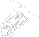
在前述方案的基础上,所述限位组件包括多个限位杆,多个钻孔杆上固定连接凸杆的一端均开设有多个储藏槽,多个所述限位杆分别设置在多个所述储藏槽内,且多个限位杆上均设置有磁吸块,多个钻孔杆上开设螺纹凹槽的一端和钻探杆的顶端均开设有多个限位槽,多个所述限位槽分别与多个限位杆匹配,多个钻孔杆均采用不能被磁性吸引的材质。On the basis of the foregoing solution, the limit assembly includes a plurality of limit rods, and one end of the plurality of drilling rods fixedly connected to the protruding rod is provided with a plurality of storage tanks, and the plurality of limit rods are respectively arranged on multiple In one of the storage tanks, and a plurality of limit rods are provided with a magnetic block, a plurality of drilling rods are provided with a threaded groove at one end and the top of the drilling rod are provided with a plurality of limit slots, and a plurality of limit slots are provided. The limiting grooves are respectively matched with a plurality of limiting rods, and the plurality of drilling rods are all made of materials that cannot be attracted by magnetism.
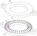
在前述方案的基础上优选的,所述磁性组件包括环形架,所述环形架固定连接在所述龙门架上,且环形架内设置有相互配合的导线和导体环。Preferably, on the basis of the foregoing solution, the magnetic assembly includes a ring frame, the ring frame is fixedly connected to the gantry frame, and a wire and a conductor ring that cooperate with each other are arranged in the ring frame.
在前述方案的基础上进一步的,所述数据传输组件包括控制箱,所述控制箱安装在所述车架上,且控制箱内安装有无线天线和控制面板,所述无线天线与控制面板配合,所述控制面板实现数据的处理和存储,所述无线天线用于控制面板内的数据上云传输,且无线天线可以实现测绘本体和测绘像机均与控制面板的数据传输。Further on the basis of the foregoing solution, the data transmission component includes a control box, the control box is installed on the vehicle frame, and a wireless antenna and a control panel are installed in the control box, and the wireless antenna cooperates with the control panel , the control panel implements data processing and storage, the wireless antenna is used for cloud transmission of data in the control panel, and the wireless antenna can realize data transmission between the surveying and mapping body and the surveying and mapping camera and the control panel.
在前述方案的基础上再进一步的,所述减震架包括轮架和转动架,所述转动架与所述轮架转动连接,转动架与所述车架转动连接,且轮架上固定连接有多个减震弓子板,多个所述减震弓子板均与车架固定连接,所述连接座与转动架固定连接。Further on the basis of the foregoing solution, the shock absorber includes a wheel frame and a turret, the turret is rotatably connected to the wheel frame, the turret is rotatably connected to the vehicle frame, and the wheel frame is fixedly connected There are a plurality of shock-absorbing bow sub-plates, and the plurality of shock-absorbing bow sub-plates are fixedly connected with the vehicle frame, and the connecting seat is fixedly connected with the turret.
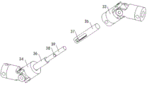
在前述方案的基础上更进一步的,所述动力轮包括山地轮和驱动电机,所述山地轮转动连接在所述轮架上,所述驱动电机安装在所述车架内,且驱动电机的输出端上通过第一万向节连接有伸缩管套,所述伸缩管套上连接有第二万向节,所述第二万向节与山地轮连接。Further on the basis of the foregoing solution, the power wheel includes a mountain wheel and a drive motor, the mountain wheel is rotatably connected to the wheel frame, the drive motor is installed in the frame, and the drive motor A telescopic sleeve is connected to the output end through a first universal joint, and a second universal joint is connected to the telescopic sleeve, and the second universal joint is connected to a mountain wheel.
作为上述方案进一步的,所述伸缩管套包括第一驱动筒和第二驱动筒,所述第一驱动筒与所述第一万向节连接,所述第二驱动筒与所述第二万向节连接,第一驱动筒上开设有调节条口,所述调节条口内设置有连接柱,所述连接柱固定连接有调节杆,所述调节杆与第二驱动筒固定连接,且调节杆滑动配合在所述第一驱动筒内。As a further embodiment of the above solution, the telescopic sleeve includes a first drive cylinder and a second drive cylinder, the first drive cylinder is connected to the first universal joint, and the second drive cylinder is connected to the second universal joint. Connected to the knuckle, the first drive cylinder is provided with an adjustment bar opening, and a connecting column is arranged in the adjustment bar opening, and the connecting column is fixedly connected with an adjustment rod, and the adjustment rod is fixedly connected with the second drive cylinder, and the adjustment rod Slip fit within said first drive barrel.
作为上述方案再进一步的,所述机械臂采用六个自由度的机械臂,且机箱的顶端安装有电动水平仪。As a further improvement of the above solution, the mechanical arm adopts a mechanical arm with six degrees of freedom, and an electric level is installed on the top of the chassis.
作为上述方案更进一步的,所述动力组件包括安装箱,所述安装箱内安装有扭矩电机,所述扭矩电机的输出轴上连接有驱动锥齿轮,所述驱动锥齿轮啮合有从动锥齿轮,所述从动锥齿轮连接在所述动力筒上。As a further embodiment of the above solution, the power assembly includes an installation box, a torque motor is installed in the installation box, a driving bevel gear is connected to the output shaft of the torque motor, and the driving bevel gear is meshed with a driven bevel gear , the driven bevel gear is connected to the power cylinder.
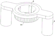
作为上述方案进一步的方案,所述动力装置包括伺服电机,所述伺服电机安装在所述车架的顶端,且伺服电机的输出轴上安装有驱动直齿轮,所述驱动直齿轮啮合有从动齿环,所述从动齿环与所述连接驱动筒连接。As a further solution of the above solution, the power device includes a servo motor, the servo motor is installed on the top of the frame, and the output shaft of the servo motor is installed with a driving spur gear, and the driving spur gear is meshed with a driven A gear ring, the driven gear ring is connected with the connecting drive cylinder.
(三)有益效果(3) Beneficial effects
与现有技术相比,本发明提供了一种电网规划用地理信息测绘工具,具备以下有益效果:Compared with the prior art, the present invention provides a geographic information surveying and mapping tool for grid planning, which has the following beneficial effects:
1.本发明中,通过数据传输组件的配备,形成数据处理中枢,能够实时接入大数据,充分利用上云技术优化测绘数据的存储和处理。1. In the present invention, through the configuration of data transmission components, a data processing center is formed, which can access big data in real time, and make full use of cloud technology to optimize the storage and processing of surveying and mapping data.
2.本发明中,通过机箱、测绘本体和机械臂的配合,形成地面测绘单元,方便实现地表上的测绘,通过圆气球、环气球、连接筒和测绘像机的配合,形成高空测绘单元,方便实现高空测绘,通过钻探杆、地质取样钻头和多个钻孔杆,方便相对于测绘地点,形成地下地质的取样测绘,从而实现多维信息的涵盖,地理信息测绘较为健全,为后续的电网规划提供的参考数据较为丰富。2. In the present invention, the ground surveying and mapping unit is formed through the cooperation of the chassis, the surveying and mapping body and the mechanical arm, which facilitates the surveying and mapping on the ground surface, and the high-altitude surveying and mapping unit is formed through the cooperation of the round balloon, the ring balloon, the connecting cylinder and the surveying and mapping camera. It is convenient to realize high-altitude surveying and mapping. Through drilling rods, geological sampling drill bits and multiple drilling rods, it is convenient to form underground geological sampling surveying and mapping relative to the surveying and mapping site, so as to realize the coverage of multi-dimensional information. The reference data provided are abundant.
3.本发明中,通过减震架和动力轮的配合,形成车架的支撑和动力行进系统,保证车架的运动行进,通过连接驱动筒的设计,方便多个钻孔杆的首尾连接,以及多个钻孔杆与钻探杆接触的一个钻孔杆与钻探杆的连接,通过磁性组件的安装,能够形成作用于限位组件的磁场,保证钻孔杆的安装和钻孔杆安装完成后的限位。3. In the present invention, through the cooperation of the shock absorber and the power wheel, the support and power travel system of the vehicle frame are formed to ensure the movement of the vehicle frame, and the design of the connecting drive cylinder facilitates the end-to-end connection of multiple drilling rods. And the connection between a drilling rod and the drilling rod in which multiple drilling rods are in contact with the drilling rod can form a magnetic field acting on the limit component through the installation of the magnetic component, ensuring that the installation of the drilling rod and the installation of the drilling rod are completed. limit.
附图说明Description of drawings
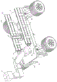
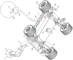
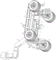
图1为本发明整体的立体结构示意图;Fig. 1 is a schematic diagram of the overall three-dimensional structure of the present invention;
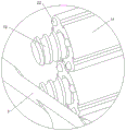
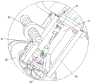
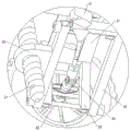
图2为本发明图1中A处的局部放大结构示意图;Fig. 2 is a schematic diagram of a partially enlarged structure at A in Fig. 1 of the present invention;
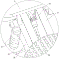
图3为本发明图1中B处的局部放大结构示意图;Fig. 3 is a schematic diagram of a partially enlarged structure at B in Fig. 1 of the present invention;
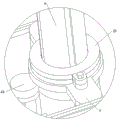
图4为本发明图1中C处的局部放大结构示意图;Fig. 4 is a schematic diagram of a partially enlarged structure at C in Fig. 1 of the present invention;
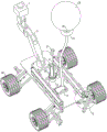
图5为本发明整体的圆气球充气展开后的仰视的立体结构示意图;Fig. 5 is a schematic diagram of the three-dimensional structure of the whole round balloon inflated and expanded according to the present invention;
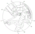
图6为本发明图5中D处的局部放大结构示意图;Fig. 6 is a schematic diagram of a partially enlarged structure at D in Fig. 5 of the present invention;
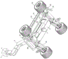
图7为本发明整体的局部剖视的仰视的立体结构示意图;Fig. 7 is the three-dimensional structural schematic diagram of the present invention's overall partial cross-sectional bottom view;
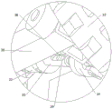
图8为本发明图7中E处的局部放大结构示意图;Fig. 8 is a schematic diagram of a partially enlarged structure at E in Fig. 7 of the present invention;
图9为本发明整体的另一种局部剖视的仰视的立体结构示意图;Fig. 9 is a perspective view of another partially cut-away bottom view of the whole of the present invention;
图10为本发明图9中F处的局部放大结构示意图;Fig. 10 is a schematic diagram of a partially enlarged structure at F in Fig. 9 of the present invention;
图11为本发明整体的俯视的立体结构示意图;Fig. 11 is a schematic three-dimensional structural schematic diagram of an overall top view of the present invention;
图12为本发明图11中G处的局部放大结构示意图;Fig. 12 is a schematic diagram of a partially enlarged structure at G in Fig. 11 of the present invention;
图13为本发明第一万向节、第二万向节和第一驱动筒等配合的分解的立体结构示意图;Fig. 13 is an exploded three-dimensional structural schematic diagram of the cooperation of the first universal joint, the second universal joint and the first drive cylinder of the present invention;
图14为本发明环形架、导线和导体环配合的分解的立体结构示意图;Fig. 14 is an exploded three-dimensional structural schematic diagram of the cooperation of the ring frame, the wire and the conductor ring of the present invention;
图15为本发明钻孔杆、限位杆和磁吸块等配合的局部剖视的立体结构示意图;Fig. 15 is a schematic diagram of a partially cut-away three-dimensional structure of the cooperation of the drilling rod, the limit rod and the magnetic block of the present invention;
图16为本发明连接驱动筒、龙门架和从动齿环配合的立体结构示意图。Fig. 16 is a three-dimensional schematic diagram of the cooperation of the connecting drive cylinder, the gantry frame and the driven gear ring according to the present invention.
图中:1、机箱;2、车架;3、机械臂;4、连接板;5、动力筒;6、钻探杆;7、地质取样钻头;8、连接驱动筒;9、龙门架;10、容纳架;11、钻孔杆;12、螺纹凹槽;13、凸杆;14、储藏箱;15、圆气球;16、环气球;17、连接筒;18、测绘像机;19、引线绳;20、连接座;21、螺纹锚杆;22、限位杆;23、磁吸块;24、限位槽;25、环形架;26、导线;27、导体环;28、控制箱;29、轮架;30、转动架;31、减震弓子板;32、山地轮;33、第一万向节;34、第二万向节;35、第一驱动筒;36、第二驱动筒;37、调节条口;38、连接柱;39、调节杆;40、安装箱;41、驱动锥齿轮;42、从动锥齿轮;43、驱动直齿轮;44、从动齿环。In the figure: 1. Chassis; 2. Vehicle frame; 3. Mechanical arm; 4. Connecting plate; 5. Power cylinder; 6. Drilling rod; 7. Geological sampling drill bit; 8. Connecting drive cylinder; , receiving frame; 11, drilling rod; 12, threaded groove; 13, protruding rod; 14, storage box; 15, round balloon; 16, ring balloon; 17, connecting cylinder; 18, surveying and mapping camera; Rope; 20, connecting seat; 21, threaded anchor rod; 22, limit rod; 23, magnetic block; 24, limit groove; 25, ring frame; 26, wire; 27, conductor ring; 28, control box; 29. Wheel frame; 30. Turret; 31. Shock-absorbing bow plate; 32. Mountain wheel; 33. The first universal joint; 34. The second universal joint; 35. The first drive cylinder; 36. The
具体实施方式Detailed ways
实施例:Example:
请参阅图1-图16,一种电网规划用地理信息测绘工具,包括机箱1,机箱1内安装有测绘本体,还包括车架2,车架2的顶端安装有机械臂3,机械臂3上安装有连接板4,机箱1与连接板4连接,通过机箱1、测绘本体和机械臂3的配合,形成地面测绘单元,方便实现地表上的测绘,机械臂3采用六个自由度的机械臂3,且机箱1的顶端安装有电动水平仪,保证机箱1调整所需求的足够自由度和机箱1的水平调控,车架2的顶端开设有钻探孔和方孔,钻探孔位于机械臂3的后侧,方孔位于钻探孔的后侧,车架2内安装有动力组件,动力组件包括安装箱40,安装箱40内安装有扭矩电机,扭矩电机的输出轴上连接有驱动锥齿轮41,驱动锥齿轮41啮合有从动锥齿轮42,从动锥齿轮42连接在动力筒5上,动力组件上安装有动力筒5,动力筒5穿过钻探孔伸出至车架2的上方,且动力筒5内设置有钻探杆6,钻探杆6的顶端开设有顶螺纹槽,钻探杆6的底端设置有地质取样钻头7,动力筒5的上方设置有连接驱动筒8,连接驱动筒8通过龙门架9安装在车架2的顶端,通过连接驱动筒8的设计,方便多个钻孔杆11的首尾连接,以及多个钻孔杆11与钻探杆6接触的一个钻孔杆11与钻探杆6的连接,且车架2的顶端安装有用于连接驱动筒8驱动的动力装置,动力装置包括伺服电机,伺服电机安装在车架2的顶端,且伺服电机的输出轴上安装有驱动直齿轮43,驱动直齿轮43啮合有从动齿环44,从动齿环44与连接驱动筒8连接。Please refer to Figures 1-16, a geographical information surveying and mapping tool for power grid planning, including a chassis 1, a surveying and mapping body is installed in the chassis 1, and a
还需进一步说明的是,连接驱动筒8的顶端设置有磁性组件,磁性组件包括环形架25,环形架25固定连接在龙门架9上,且环形架25内设置有相互配合的导线26和导体环27,通过磁性组件的安装,能够形成作用于限位组件的磁场,保证钻孔杆11的安装和钻孔杆11安装完成后的限位,车架2的顶端固定连接有容纳架10,容纳架10内设置有多个钻孔杆11,通过钻探杆6、地质取样钻头7和多个钻孔杆11,方便相对于测绘地点,形成地下地质的取样测绘,从而实现多维信息的涵盖,地理信息测绘较为健全,为后续的电网规划提供的参考数据较为丰富,多个钻孔杆11的一端开设有螺纹凹槽12,多个钻孔杆11的另一端固定连接有凸杆13,多个钻孔杆11上固定连接凸杆13的一端安装有限位组件,限位组件包括多个限位杆22,多个钻孔杆11上固定连接凸杆13的一端均开设有多个储藏槽,多个限位杆22分别设置在多个储藏槽内,且多个限位杆22上均设置有磁吸块23,多个钻孔杆11上开设螺纹凹槽12的一端和钻探杆6的顶端均开设有多个限位槽24,多个限位槽24分别与多个限位杆22匹配,多个钻孔杆11均采用不能被磁性吸引的材质,保证钻孔杆11的安装和钻孔杆11安装完成后的限位,方孔内设置有储藏箱14,储藏箱14内设置有圆气球15和环气球16,圆气球15与环气球16之间通过连接筒17连接,连接筒17上安装有测绘像机18,通过圆气球15、环气球16、连接筒17和测绘像机18的配合,形成高空测绘单元,方便实现高空测绘。It should be further explained that the top end of the
还需更进一步说明的是,连接筒17固定连接有引线绳19,引线绳19连接在储藏箱14内,车架2的四角位置处均安装有减震架,四个减震架上均安装有动力轮,四个减震架上均连接有连接座20,四个连接座20上均安装有螺纹锚杆21,减震架包括轮架29和转动架30,转动架30与轮架29转动连接,转动架30与车架2转动连接,且轮架29上固定连接有多个减震弓子板31,多个减震弓子板31均与车架2固定连接,连接座20与转动架30固定连接,动力轮包括山地轮32和驱动电机,山地轮32转动连接在轮架29上,驱动电机安装在车架2内,且驱动电机的输出端上通过第一万向节33连接有伸缩管套,伸缩管套上连接有第二万向节34,第二万向节34与山地轮32连接,通过减震架和动力轮的配合,形成车架2的支撑和动力行进系统,保证车架2的运动行进,伸缩管套包括第一驱动筒35和第二驱动筒36,第一驱动筒35与第一万向节33连接,第二驱动筒36与第二万向节34连接,第一驱动筒35上开设有调节条口37,调节条口37内设置有连接柱38,连接柱38固定连接有调节杆39,调节杆39与第二驱动筒36固定连接,且调节杆39滑动配合在第一驱动筒35内,保证驱动电机向山地轮32的动力输出,车架2的前侧安装有数据传输组件,数据传输组件包括控制箱28,控制箱28安装在车架2上,且控制箱28内安装有无线天线和控制面板,无线天线与控制面板配合,控制面板实现数据的处理和存储,无线天线用于控制面板内的数据上云传输,且无线天线可以实现测绘本体和测绘像机18均与控制面板的数据传输,通过数据传输组件的配备,形成数据处理中枢,能够实时接入大数据,充分利用上云技术优化测绘数据的存储和处理。It should be further explained that the connecting
该实施例中的机械臂3、地质取样钻头7、测绘像机18、驱动电机、电动水平仪、扭矩电机、伺服电机、无线天线和控制面板均为市面上购买的本领域技术人员公知的常规设备,也可以根据实际需要进行定制,本专利中我们只是对其进行使用,并未对其结构和功能进行改进,其设定方式、安装方式和电性连接方式,对于本领域的技术人员来说,只要按照其使用说明书的要求进行调试操作即可,在此不再对其进行赘述,且测绘本体在机箱1内的安装方式可以选用背景技术中公开号为CN112212838B的对比专利中的对应安装结构,同时车架2内配套有电力供应装置,电力供应装置可以是蓄电池也可以是发动机带动发电机的组合系统。
综上所述,该电网规划用地理信息测绘工具的工作过程为,在使用时,首先将该电网规划用地理信息测绘工具移动至所需测绘的地点,移动过程中通过驱动电机工作驱动山地轮32实现车架2的移动,然后根据测绘需要选取地表、高空和地下三种测绘方式中的一种或多种,当选取地表测绘时,机械臂3工作实现机箱1的位置的调整,同时机械臂3调整过程中配合电动水平仪工作实现对于机箱1的水平调整,从而保证测绘本体的水平测绘,当需要高空测绘时,人工将圆气球15和环气球16从储藏箱14内取出,然后为圆气球15和环气球16充入升空气体,升空气体选取比空气密度小的气体,然后将充气后的圆气球15和环气球16放开升空,升空后的测绘相机实现地理信息的高空测绘,当需要地下测绘时,首先将螺纹锚杆21插入地下,实现车架2的稳固,在通过扭矩电机实现钻探杆6的转动驱动,钻探杆6转动过程中其下方的地质取样钻头7协同工作实现相对于地面的钻孔,并且当钻探杆6的长度不够时可以将钻孔杆11配合钻探杆6使用,以提高地质取样钻头7钻入地下的深度,实现地下样本的取出,从而实现地下测绘的进行,当钻孔杆11与钻探杆6连接时,切断扭矩电机的电源使钻探杆6停止转动,将钻孔杆11插入连接驱动筒8,钻孔杆11会在自身重力的作用下相对于连接驱动筒8下落,伴随着钻孔杆11的下落,导线26通电使导线26和导体环27相互配合的结构产生电磁场,该电磁场作用于插入连接驱动筒8内的钻孔杆11内的磁吸块23,使磁吸块23在磁场作用下暂时不随钻孔杆11的下落而下落,即磁吸块23相对于钻孔杆11向上运动,使限位杆22完全被收入储藏槽,保持导线26内的电流,维持电磁场,伺服电机工作控制连接驱动筒8转动,连接驱动筒8转动实现钻孔杆11的转动驱动,钻孔杆11转动使其下方的凸杆13进入钻探杆6顶端的顶螺纹槽内,实现钻孔杆11与钻探杆6的连接,连接完成后切断导线26内的电流,电磁场消失,如此对于磁吸块23的磁力作用失效,然后磁吸块23和限位杆22在自身重力的作用下落入钻探杆6上的限位槽24内,从而保证凸杆13在顶螺纹槽的连接可靠性,同理当多个钻孔杆11首尾连接时,重复上述操作,将上下相互连接的上侧的钻孔杆11上的凸杆13螺纹连接在下侧的钻孔杆11上的螺纹凹槽12内即可。To sum up, the working process of the geographic information surveying and mapping tool for power grid planning is as follows. 32 to realize the movement of the
Claims (6)
Priority Applications (1)
| Application Number | Priority Date | Filing Date | Title |
|---|---|---|---|
| CN202310141478.5A CN115855006B (en) | 2023-02-21 | 2023-02-21 | Geographic information mapping tool for power grid planning |
Applications Claiming Priority (1)
| Application Number | Priority Date | Filing Date | Title |
|---|---|---|---|
| CN202310141478.5A CN115855006B (en) | 2023-02-21 | 2023-02-21 | Geographic information mapping tool for power grid planning |
Publications (2)
| Publication Number | Publication Date |
|---|---|
| CN115855006A CN115855006A (en) | 2023-03-28 |
| CN115855006B true CN115855006B (en) | 2023-05-12 |
Family
ID=85658497
Family Applications (1)
| Application Number | Title | Priority Date | Filing Date |
|---|---|---|---|
| CN202310141478.5A Expired - Fee Related CN115855006B (en) | 2023-02-21 | 2023-02-21 | Geographic information mapping tool for power grid planning |
Country Status (1)
| Country | Link |
|---|---|
| CN (1) | CN115855006B (en) |
Cited By (1)
| Publication number | Priority date | Publication date | Assignee | Title |
|---|---|---|---|---|
| US11955782B1 (en) | 2022-11-01 | 2024-04-09 | Typhon Technology Solutions (U.S.), Llc | System and method for fracturing of underground formations using electric grid power |
Citations (2)
| Publication number | Priority date | Publication date | Assignee | Title |
|---|---|---|---|---|
| JPH11270269A (en) * | 1998-03-25 | 1999-10-05 | East Japan Railway Co | Ground drilling extension detection device, ground drilling extension detection method, ground drilling extension management method, chemical injection drilling extension management method, chemical injection depth detection device, and chemical injection depth detection method |
| CN215632747U (en) * | 2021-08-13 | 2022-01-25 | 孙恺 | Novel geological planning is reconnaissance probing for design device |
Family Cites Families (11)
| Publication number | Priority date | Publication date | Assignee | Title |
|---|---|---|---|---|
| US7069124B1 (en) * | 2002-10-28 | 2006-06-27 | Workhorse Technologies, Llc | Robotic modeling of voids |
| CN108915604B (en) * | 2018-07-04 | 2020-08-11 | 武汉君泊天下网络科技有限公司 | Drilling mechanism for parking lot construction |
| CN111287169A (en) * | 2020-02-14 | 2020-06-16 | 王俊霞 | Auxiliary pressing device for chain type ground tamper of agricultural machine |
| CN111220136A (en) * | 2020-02-18 | 2020-06-02 | 山东省物化探勘查院 | Supplementary mapping device of multi-functional city three-dimensional topography |
| CN112197753B (en) * | 2020-09-11 | 2022-04-05 | 中冶集团武汉勘察研究院有限公司 | An Intelligent Geographic Information Measurement and Drawing System |
| CN113112218A (en) * | 2021-03-22 | 2021-07-13 | 福建升晖工程管理有限公司 | Landscape engineering measurement system |
| CN214732702U (en) * | 2021-05-05 | 2021-11-16 | 郑芷茜 | Plug-type electromagnetic adsorption device |
| CN113776507A (en) * | 2021-10-07 | 2021-12-10 | 叶丽 | Land planning measurer based on laser mapping |
| CN114018230B (en) * | 2021-12-15 | 2022-07-05 | 山东柏远复合材料科技股份有限公司 | Air-ground integrated three-dimensional surveying and mapping device |
| CN115248297A (en) * | 2022-01-13 | 2022-10-28 | 重庆工程职业技术学院 | System and method for comprehensive mapping and analysis of field geological remote sensing |
| CN115031711B (en) * | 2022-07-13 | 2023-10-31 | 山东省煤田地质局物探测量队 | Geographic information acquisition device for territorial space mapping |
-
2023
- 2023-02-21 CN CN202310141478.5A patent/CN115855006B/en not_active Expired - Fee Related
Patent Citations (2)
| Publication number | Priority date | Publication date | Assignee | Title |
|---|---|---|---|---|
| JPH11270269A (en) * | 1998-03-25 | 1999-10-05 | East Japan Railway Co | Ground drilling extension detection device, ground drilling extension detection method, ground drilling extension management method, chemical injection drilling extension management method, chemical injection depth detection device, and chemical injection depth detection method |
| CN215632747U (en) * | 2021-08-13 | 2022-01-25 | 孙恺 | Novel geological planning is reconnaissance probing for design device |
Cited By (2)
| Publication number | Priority date | Publication date | Assignee | Title |
|---|---|---|---|---|
| US11955782B1 (en) | 2022-11-01 | 2024-04-09 | Typhon Technology Solutions (U.S.), Llc | System and method for fracturing of underground formations using electric grid power |
| US12444910B2 (en) | 2022-11-01 | 2025-10-14 | Typhon Technology Solutions (U.S.), Llc | Method for accessing electric grids to power fracturing operations |
Also Published As
| Publication number | Publication date |
|---|---|
| CN115855006A (en) | 2023-03-28 |
Similar Documents
| Publication | Publication Date | Title |
|---|---|---|
| CN110824547A (en) | Seismic source geophone integrated device and method for seismic method exploration | |
| CN114001247A (en) | Mapping device for geographic information and using method thereof | |
| CN218759696U (en) | Portable drilling device for geotechnical engineering investigation | |
| CN115042964A (en) | A soil sampling unmanned aerial vehicle for land survey | |
| CN115855006A (en) | A Geographic Information Surveying and Mapping Tool for Grid Planning | |
| CN221032406U (en) | Drilling device for geotechnical engineering investigation | |
| CN111220136A (en) | Supplementary mapping device of multi-functional city three-dimensional topography | |
| CN117571368A (en) | Mine geological survey probing sampling device | |
| CN212079196U (en) | Combined drilling equipment for advance prediction of tunnel | |
| CN211314134U (en) | Oil drilling device with drill bit convenient to replace | |
| CN113586907A (en) | Acquisition, investigation and compilation comprehensive processing device for space-time data of natural resources | |
| CN212103583U (en) | Uneven road detection device convenient to remove | |
| CN220890112U (en) | Engineering geological investigation rig | |
| CN219475011U (en) | Core sampling device | |
| CN217655117U (en) | Coal mine tunnel country rock stability monitoring devices | |
| CN216847002U (en) | Be used for engineering geology reconnaissance sampling device | |
| CN223661729U (en) | Drilling mechanism for mine survey | |
| CN210858598U (en) | Quick geological exploration drilling machine | |
| CN207516071U (en) | A kind of boring and coring equipment for geological prospecting | |
| CN116733375A (en) | Drilling device for adjustable multi-angle coal mining | |
| CN211342767U (en) | Fixing frame convenient to install for geological exploration drilling machine | |
| CN222687864U (en) | Positioning marker post based on geological mapping | |
| CN113624541A (en) | Exploration sampling device for construction | |
| CN217233423U (en) | Drilling device for geological survey | |
| CN208921474U (en) | Novel geological engineering sampler |
Legal Events
| Date | Code | Title | Description |
|---|---|---|---|
| PB01 | Publication | ||
| PB01 | Publication | ||
| SE01 | Entry into force of request for substantive examination | ||
| SE01 | Entry into force of request for substantive examination | ||
| GR01 | Patent grant | ||
| GR01 | Patent grant | ||
| CF01 | Termination of patent right due to non-payment of annual fee |
Granted publication date: 20230512 |
|
| CF01 | Termination of patent right due to non-payment of annual fee |